wt360 Weather Brief 4 July '26: Heat Shifting West, Northeast Cooler/Wetter
Captain's Log
4 July 2026: Happy 250th Independence Day Weekend! :)
We're going to ask wt360 robot SUNNY everything from a summary of this July 4th weekend and the influence on seasonal sales to El Nino, fires, drought, dust, hurricanes... CLICK ON IMAGES FOR A LARGER VIEW
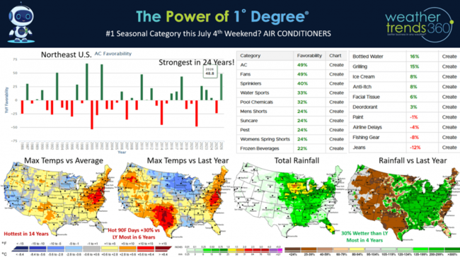
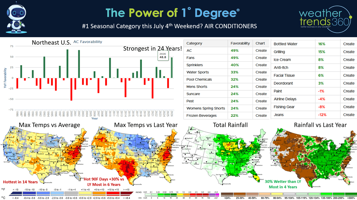
This 4th of July weekend (3-5 July) is obviously bringing scorching hot weather to the Northeast with 100F+ temperatures. Our AC category index shows a +50% increase in AC demand vs last year and the highest sales index value in 24 years! This is good news after the coldest last week of June in 22 years, so the demand surge is very significant. The U.S. overall is trending the hottest in 14 years, hot 90F days up +30% and the most in 6 years, while rainfall is also up +30% and the most in 4 years. These are very strong trends for hot Summer seasonal categories like AC, Pool Chemicals, Suncare, Cold Beverages, Frozen Beverages, etc. Not so good for Jeans, Fishing Gear (too hot too wet) and increased airline delays.
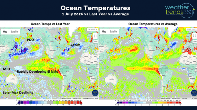
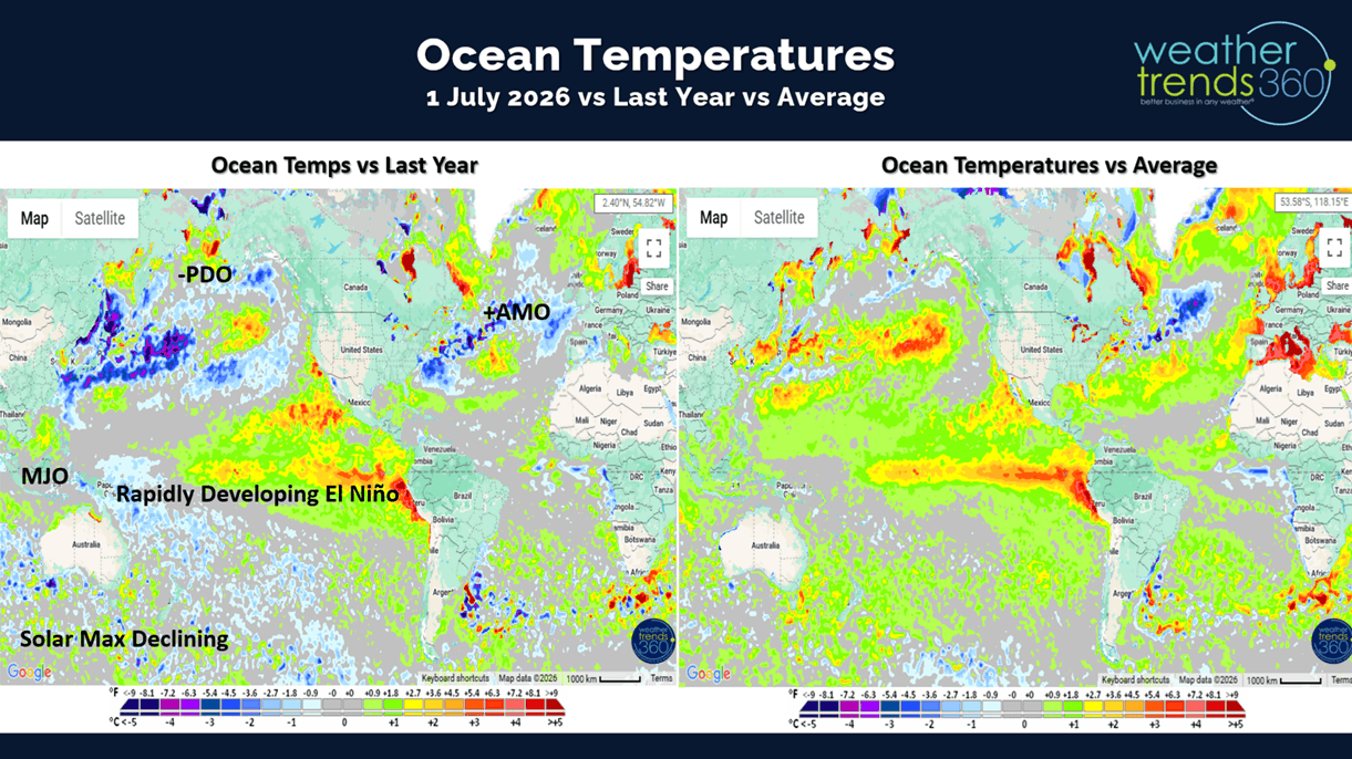
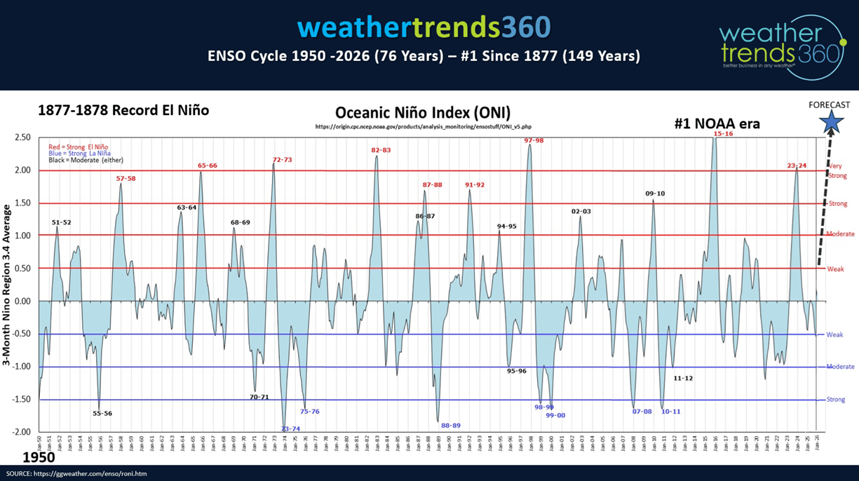
El Niño clearly headed for a near historic event with rapidly warming Equatorial Pacific Ocean temperatures. On par with the 2015-2016 #2 event and the #1 1877-1878 (149 years ago).
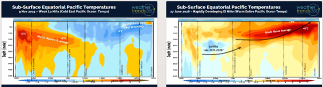
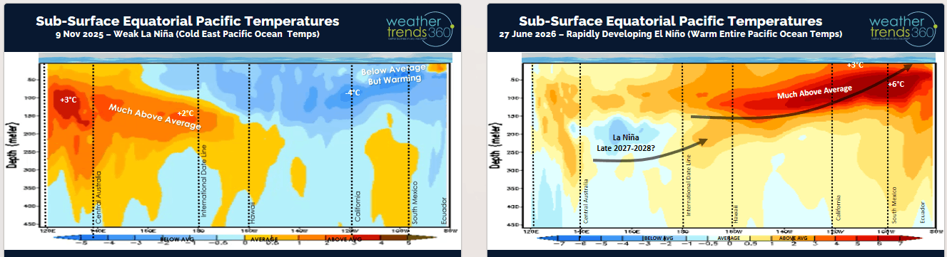
The sub-surface ocean temperatures show +6F above average water temperatures percolating to the surface, we only +2.5F to be in the historic level.
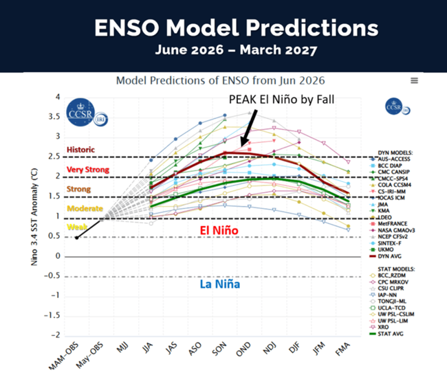
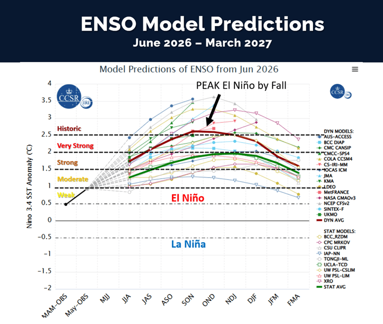
Models continue to show we'll top that level by Fall. Very likely this will start to dramatically increase the rainfall in the U.S. for late Summer, Fall and Winter into Spring 2027.
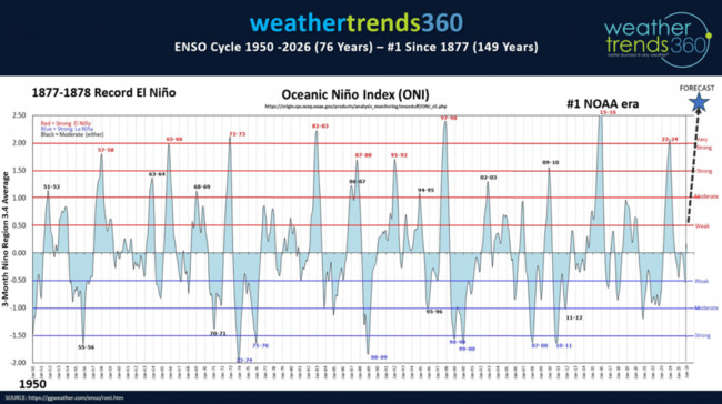
Data from 1950 when NOAA started actively monitoring El Niño shows 2015-2016 as #1, 1997-1998 #2 and 1982-1983 #3. This year likely to top them all.
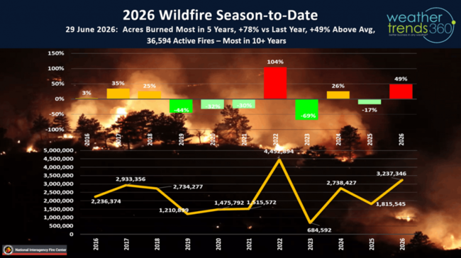
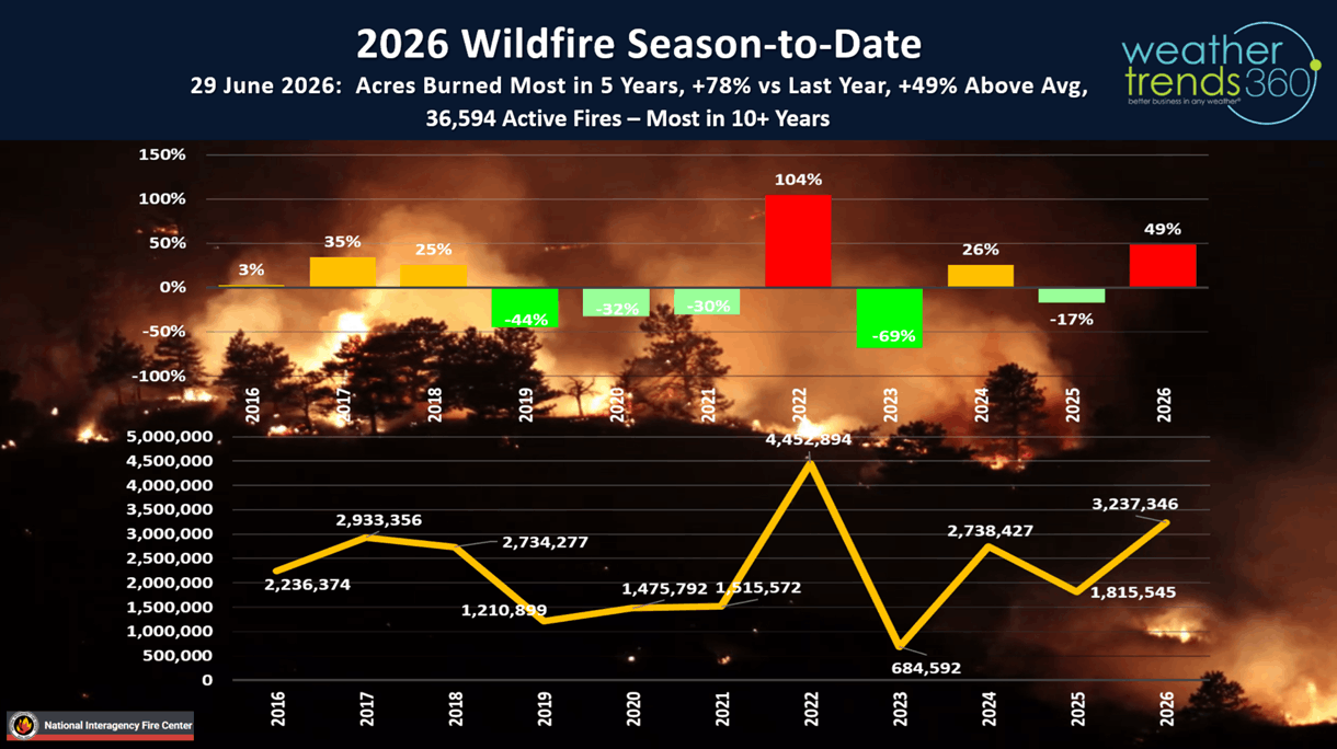
Before the floods, come the fires and they're off to a strong start in 2026 with the most acres burned in 5 years (3.2M), most active fires in 10+ years (36.5K), +78% above last year and +49% above average. This will be an increasing theme in the West this Fall as rains won't arrive until early Winter.
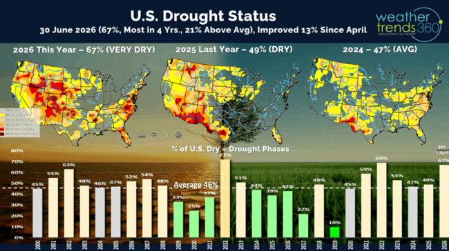
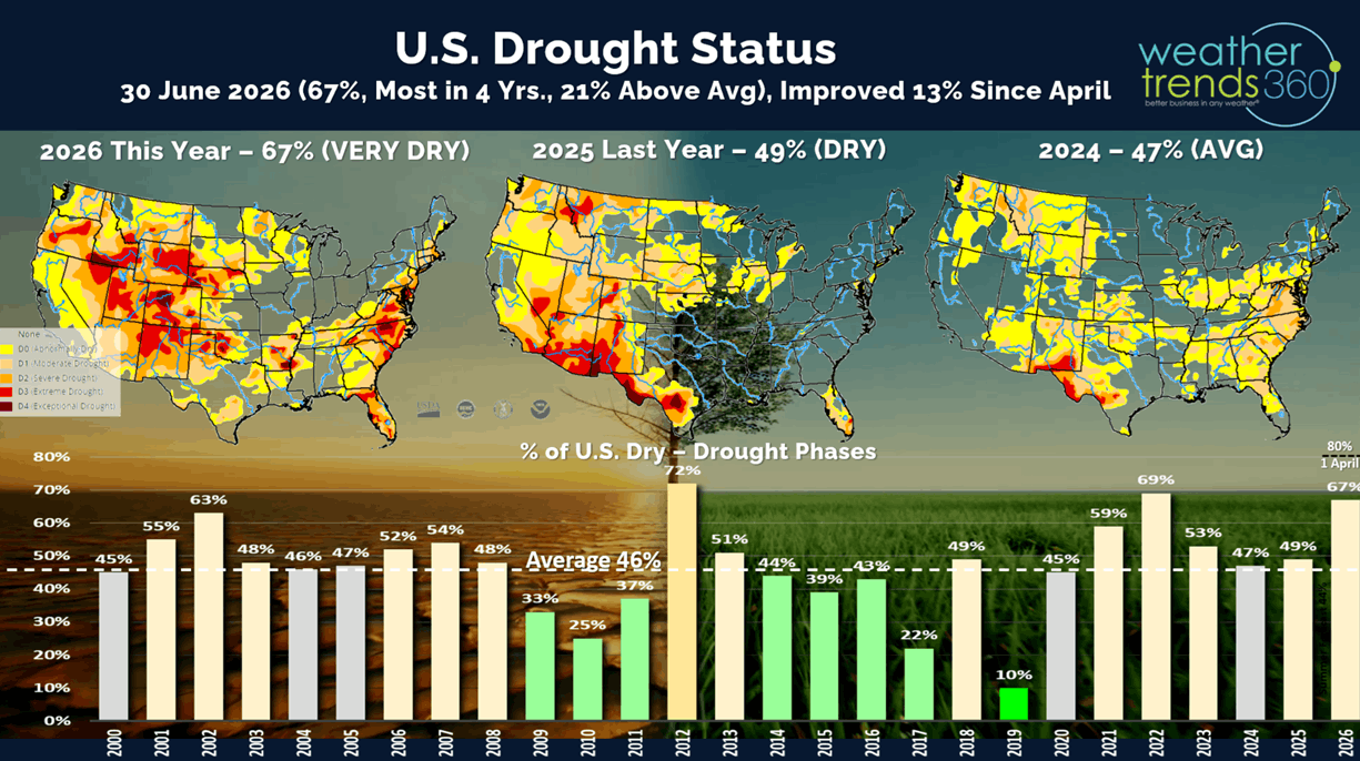
Drought has made some improvement after peaking at 80% of the U.S. in dry to drought phases back on 1 April and now down to 67% of the U.S. in drought phases. This is still the most in 4 years, +21% above average.
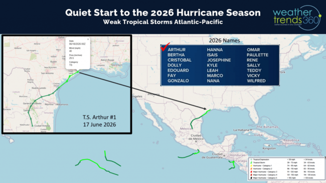
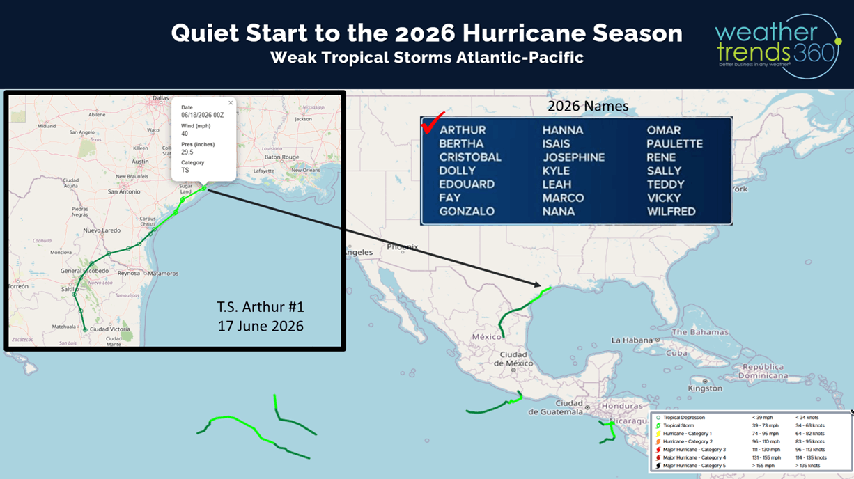
With El Niño, there are inhibiting factors like windshear that suppress tropical activity. So far that's the case with just one weak short-lived Tropical Storm Arthur in Texas and four week T.S. in the Eastern Pacific.
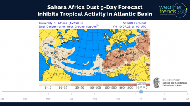
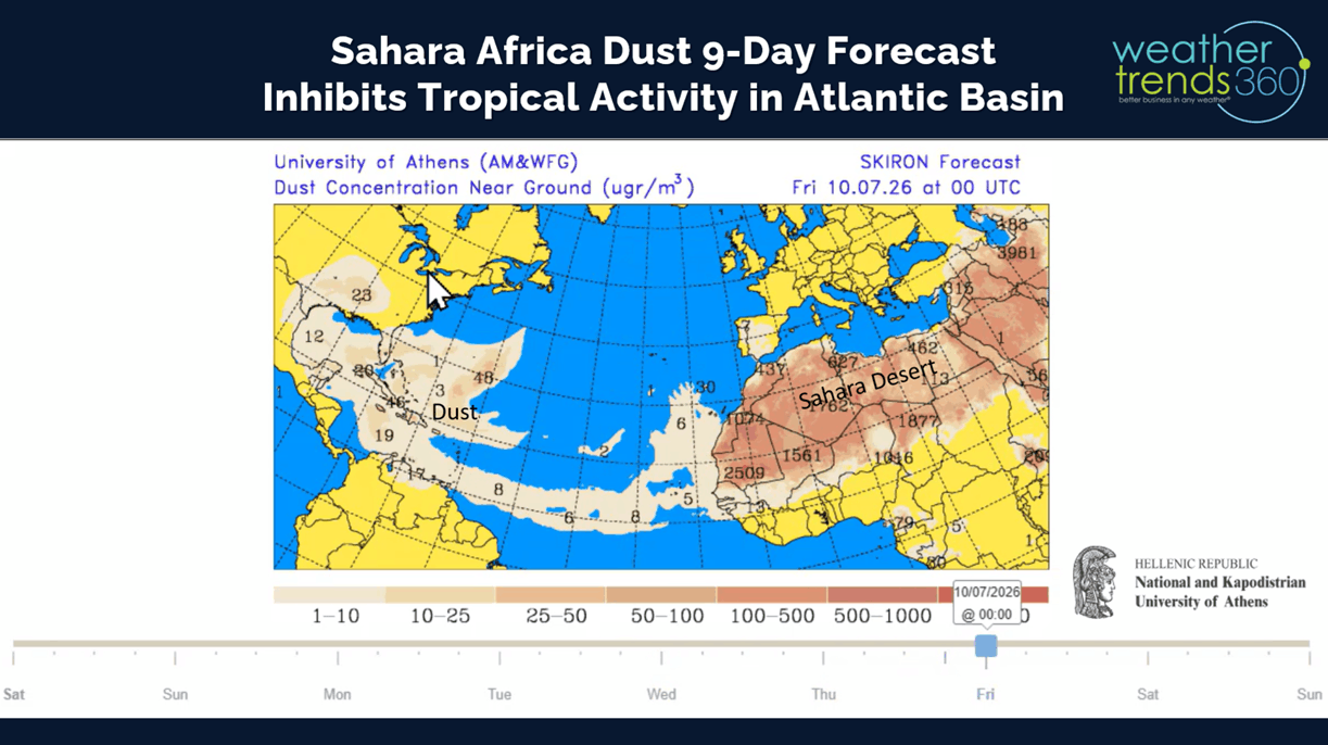
Sahara Dust coming off Africa is making its way to the Caribbean and Southeast U.S. which is another inhibiting factor for tropical development.
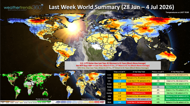
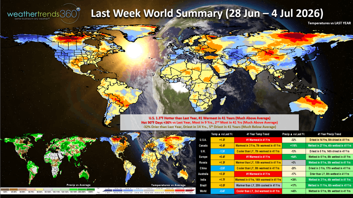
Last Week (28 Jun - 4 Jul) across the World shows the U.S. making a huge flip flop from the coolest end to June in 22 years to the #1 hottest start to July. National temperatures +1.3F warmer than last year and hot 90F days up +36% and most in 9 years. Rainfall -32% vs last year and driest in 14 years. These are very favorable trends for the really hot Summer seasonal categories like AC, Auto Batteries, Antifreeze, Pool Chemicals, Water Toys, Suncare, Cold Beverages, Frozen Treats, etc. West-Central Europe cooled off a bit after scorching heat in late June, but another heatwave on the way. Record warm Winter weather in Australia has FLU cases plummeting -65% vs last year suggesting a very late peak suppressed season down under.
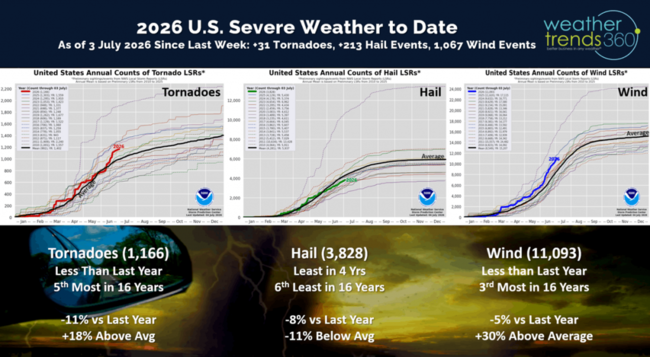
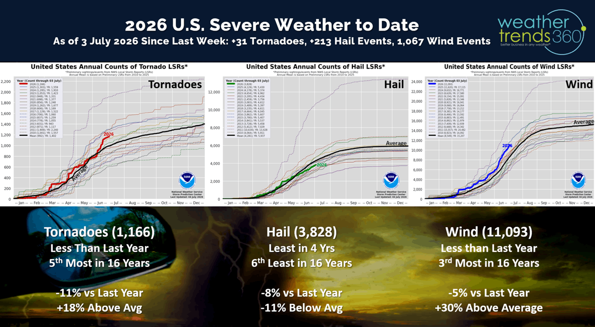
Severe Weather across the U.S. added 31 tornadoes, 213 hail events and a significant 1,067 wind events this past week. All metrics trending below last year's levels, but tornadoes and wind cases still well above average.
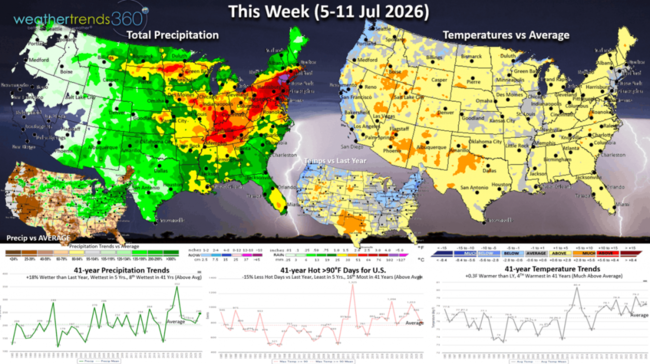
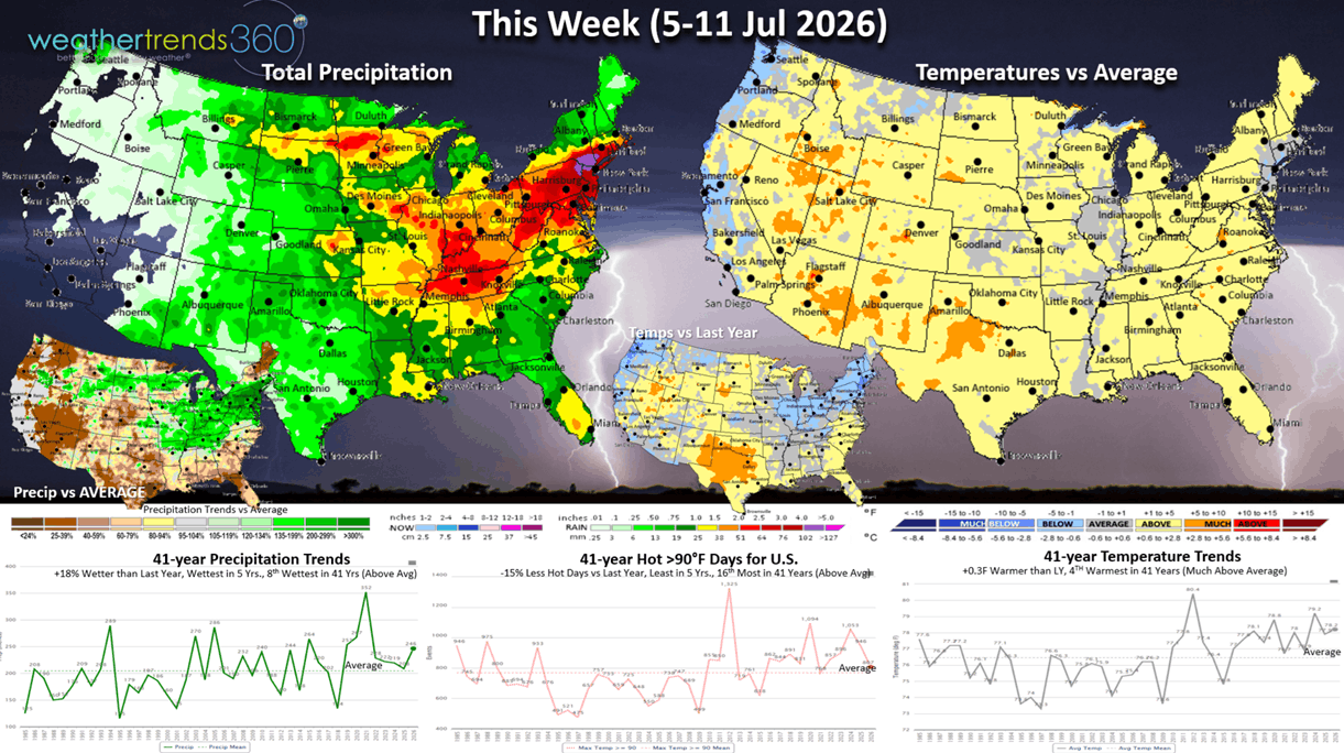
This week (5-11 July) shows a moderating trend with the extreme heatwave ending in the Northeast now with a 30 degree plunge in temperatures and much needed 3-5" rainfall totals. The heat will start to shift back to the West and Upper Plains. The U.S. overall trends +0.3F warmer than last year and 4th warmest of the past 41 years, but the HOT 90F index is down -15% vs last year, least in 5 years, while rainfall is up +18%, wettest in 5 years and 8th wettest of the past 41 years. Look for a big drop in seasonal sales after the peak week this past weekend.
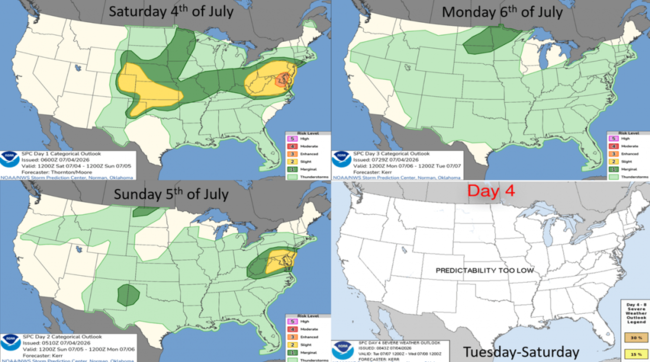
The week ahead severe weather outlook shows the risk for more severe weather this weekend in the Eastern U.S. and then abating a bit as we go into next week.
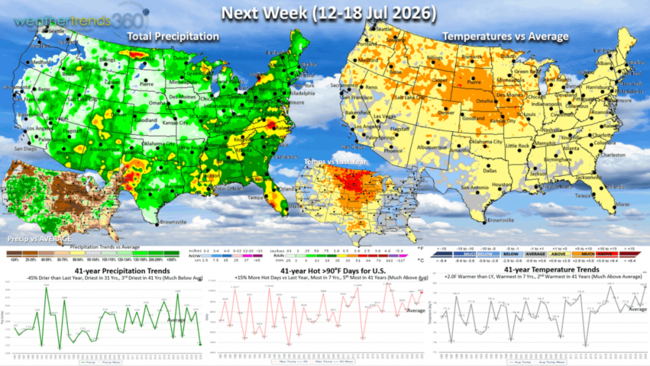
Next week (12-18 July) shows the heat dome setting up in the West and North Central U.S. with slightly above average temps in the East although cooler than last year. The East could trend cooler than depicted here. The U.S. overall trends +2F warmer than last year, warmest in 7 years and 2nd warmest in 41 years, with hot 90F days up +15%, most in 7 years and 5th most in 41 years. Rainfall way down -45% vs LY, least in 31 years and 3rd driest in 41 years. These are still favorable trends for consumable seasonal categories like cold beverages, fruits, suncare, etc.
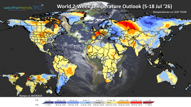
The World 2-week temperature outlook (5-18 July) shows the extreme heat coming back to West-Central Europe with more 100F+ temps, while the heat in the U.S. shifts to the North Central U.S.
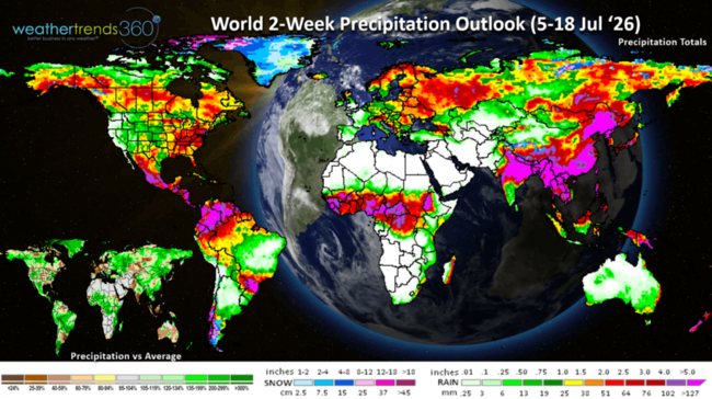
The World 2-week precipitation outlook (5-18 July) shows very dry conditions for the Southern U.S., U.K., Central Europe and Australia.
You can get this blog in your email inbox every weekend (FREE) via subscription.
Have a great week ahead, and don't forget to follow us on social media for updates: Facebook, Twitter(X), YouTube, Pinterest and Linkedin.
- Captain Kirk out (USAF Gulf War Veteran 1989-1999)
We're going to ask wt360 robot SUNNY everything from a summary of this July 4th weekend and the influence on seasonal sales to El Nino, fires, drought, dust, hurricanes... CLICK ON IMAGES FOR A LARGER VIEW
This 4th of July weekend (3-5 July) is obviously bringing scorching hot weather to the Northeast with 100F+ temperatures. Our AC category index shows a +50% increase in AC demand vs last year and the highest sales index value in 24 years! This is good news after the coldest last week of June in 22 years, so the demand surge is very significant. The U.S. overall is trending the hottest in 14 years, hot 90F days up +30% and the most in 6 years, while rainfall is also up +30% and the most in 4 years. These are very strong trends for hot Summer seasonal categories like AC, Pool Chemicals, Suncare, Cold Beverages, Frozen Beverages, etc. Not so good for Jeans, Fishing Gear (too hot too wet) and increased airline delays.
El Niño clearly headed for a near historic event with rapidly warming Equatorial Pacific Ocean temperatures. On par with the 2015-2016 #2 event and the #1 1877-1878 (149 years ago).
The sub-surface ocean temperatures show +6F above average water temperatures percolating to the surface, we only +2.5F to be in the historic level.
Models continue to show we'll top that level by Fall. Very likely this will start to dramatically increase the rainfall in the U.S. for late Summer, Fall and Winter into Spring 2027.
Data from 1950 when NOAA started actively monitoring El Niño shows 2015-2016 as #1, 1997-1998 #2 and 1982-1983 #3. This year likely to top them all.
Before the floods, come the fires and they're off to a strong start in 2026 with the most acres burned in 5 years (3.2M), most active fires in 10+ years (36.5K), +78% above last year and +49% above average. This will be an increasing theme in the West this Fall as rains won't arrive until early Winter.
Drought has made some improvement after peaking at 80% of the U.S. in dry to drought phases back on 1 April and now down to 67% of the U.S. in drought phases. This is still the most in 4 years, +21% above average.
With El Niño, there are inhibiting factors like windshear that suppress tropical activity. So far that's the case with just one weak short-lived Tropical Storm Arthur in Texas and four week T.S. in the Eastern Pacific.
Sahara Dust coming off Africa is making its way to the Caribbean and Southeast U.S. which is another inhibiting factor for tropical development.
Last Week (28 Jun - 4 Jul) across the World shows the U.S. making a huge flip flop from the coolest end to June in 22 years to the #1 hottest start to July. National temperatures +1.3F warmer than last year and hot 90F days up +36% and most in 9 years. Rainfall -32% vs last year and driest in 14 years. These are very favorable trends for the really hot Summer seasonal categories like AC, Auto Batteries, Antifreeze, Pool Chemicals, Water Toys, Suncare, Cold Beverages, Frozen Treats, etc. West-Central Europe cooled off a bit after scorching heat in late June, but another heatwave on the way. Record warm Winter weather in Australia has FLU cases plummeting -65% vs last year suggesting a very late peak suppressed season down under.
Severe Weather across the U.S. added 31 tornadoes, 213 hail events and a significant 1,067 wind events this past week. All metrics trending below last year's levels, but tornadoes and wind cases still well above average.
This week (5-11 July) shows a moderating trend with the extreme heatwave ending in the Northeast now with a 30 degree plunge in temperatures and much needed 3-5" rainfall totals. The heat will start to shift back to the West and Upper Plains. The U.S. overall trends +0.3F warmer than last year and 4th warmest of the past 41 years, but the HOT 90F index is down -15% vs last year, least in 5 years, while rainfall is up +18%, wettest in 5 years and 8th wettest of the past 41 years. Look for a big drop in seasonal sales after the peak week this past weekend.
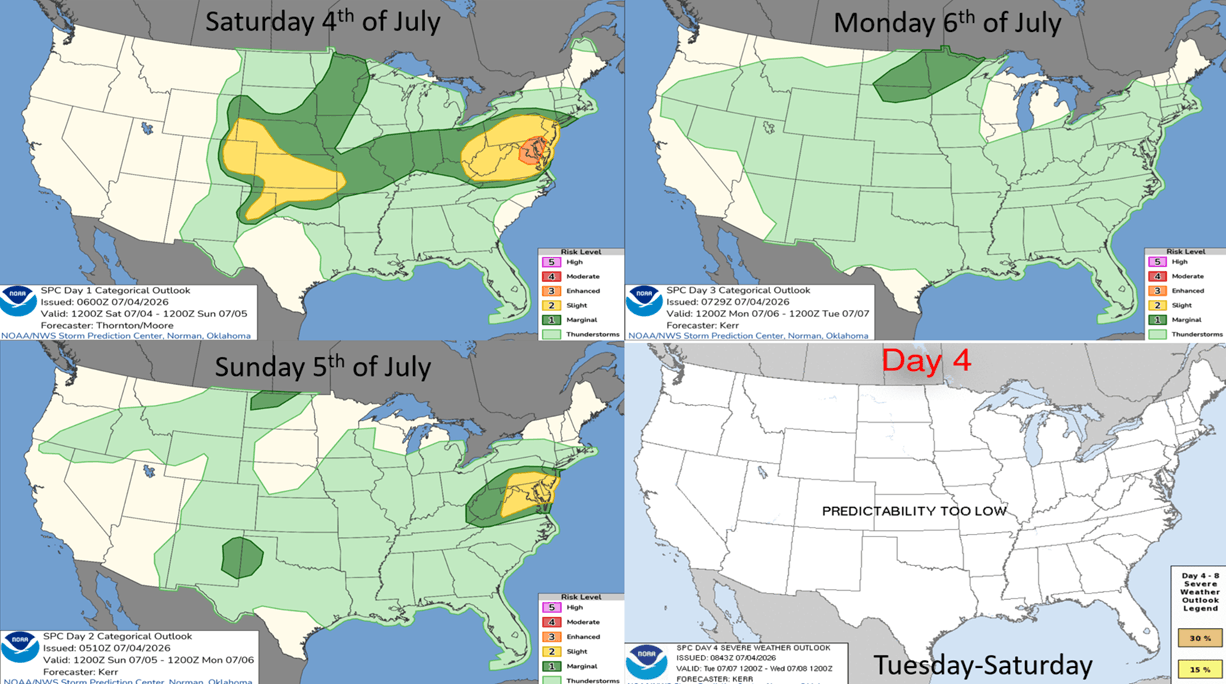
The week ahead severe weather outlook shows the risk for more severe weather this weekend in the Eastern U.S. and then abating a bit as we go into next week.
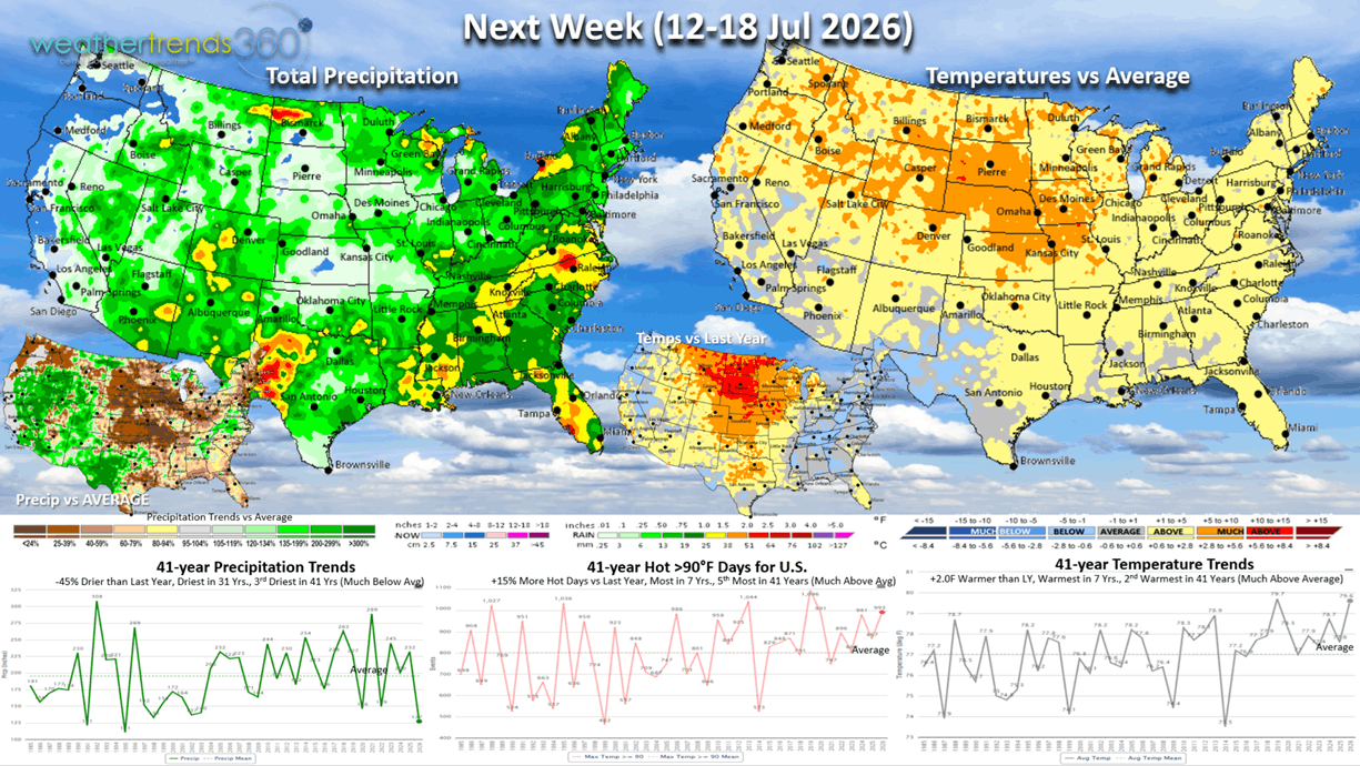
Next week (12-18 July) shows the heat dome setting up in the West and North Central U.S. with slightly above average temps in the East although cooler than last year. The East could trend cooler than depicted here. The U.S. overall trends +2F warmer than last year, warmest in 7 years and 2nd warmest in 41 years, with hot 90F days up +15%, most in 7 years and 5th most in 41 years. Rainfall way down -45% vs LY, least in 31 years and 3rd driest in 41 years. These are still favorable trends for consumable seasonal categories like cold beverages, fruits, suncare, etc.
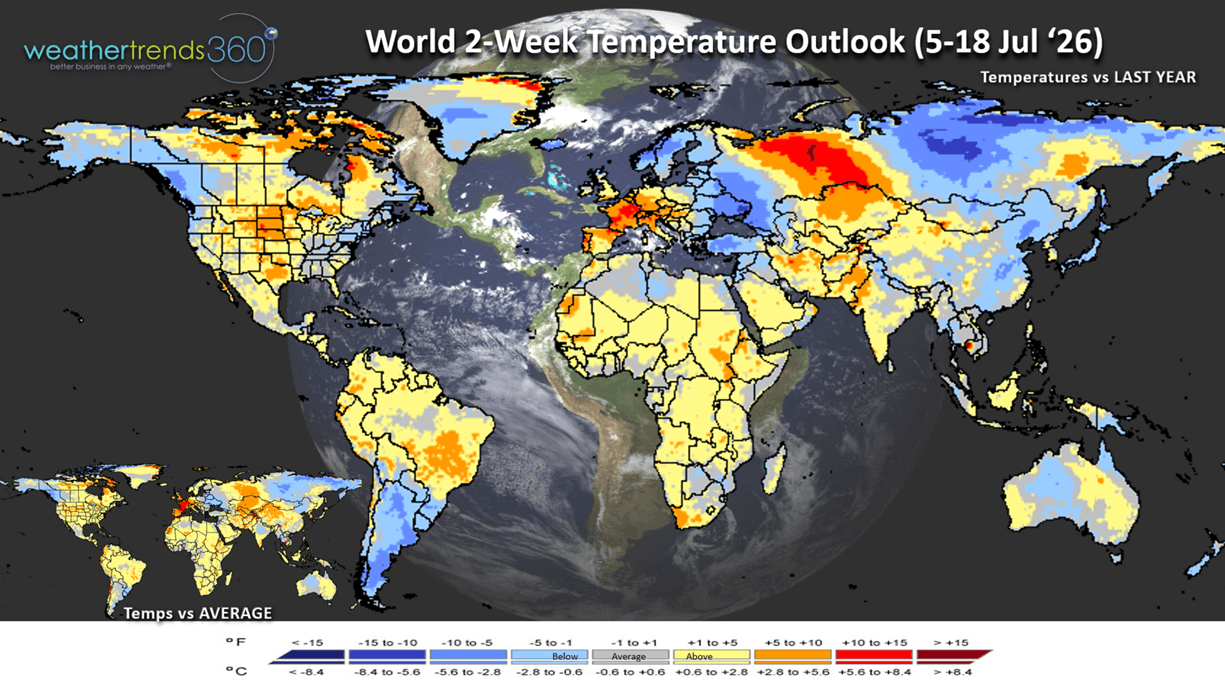
The World 2-week temperature outlook (5-18 July) shows the extreme heat coming back to West-Central Europe with more 100F+ temps, while the heat in the U.S. shifts to the North Central U.S.
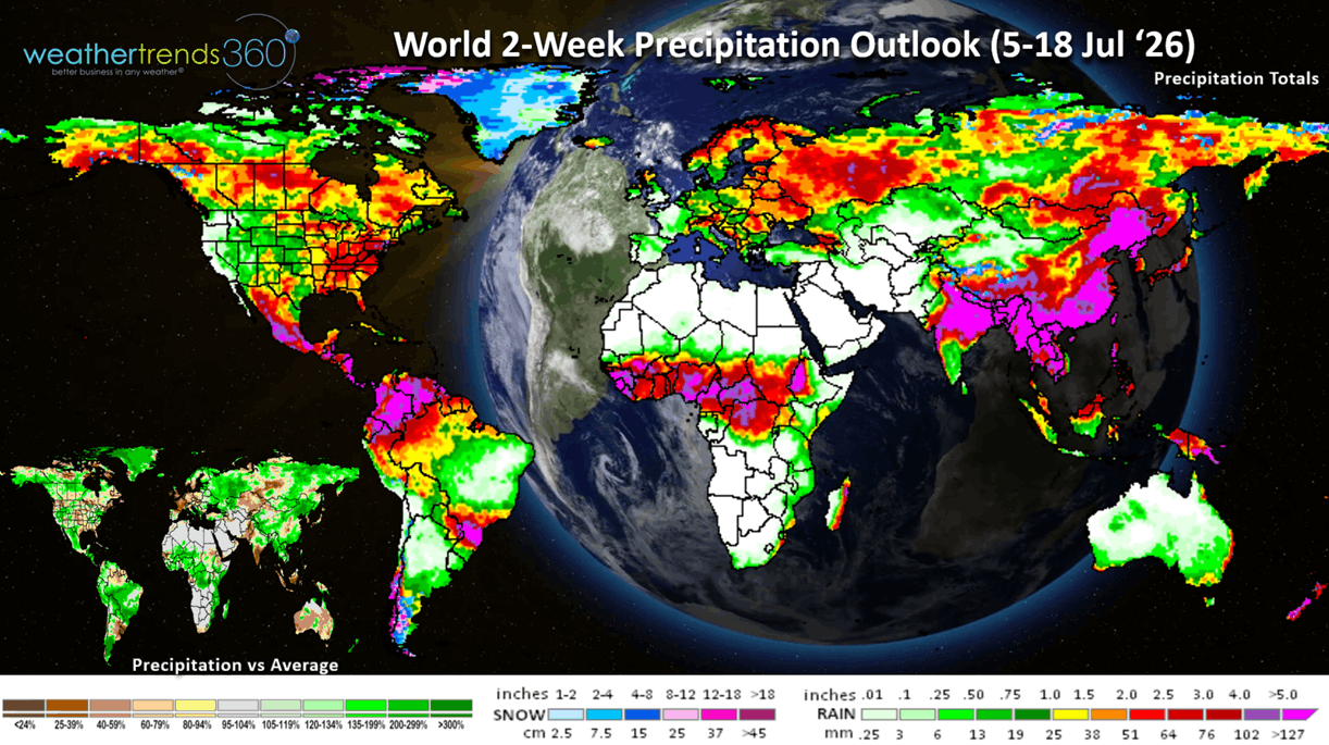
The World 2-week precipitation outlook (5-18 July) shows very dry conditions for the Southern U.S., U.K., Central Europe and Australia.
You can get this blog in your email inbox every weekend (FREE) via subscription.
Have a great week ahead, and don't forget to follow us on social media for updates: Facebook, Twitter(X), YouTube, Pinterest and Linkedin.
- Captain Kirk out (USAF Gulf War Veteran 1989-1999)