wt360 Weather Brief 4 Apr '26 - Wettest Front Half of April in 13 Years
Captain's Log
4 Apr '26: Happy Saturday! :)
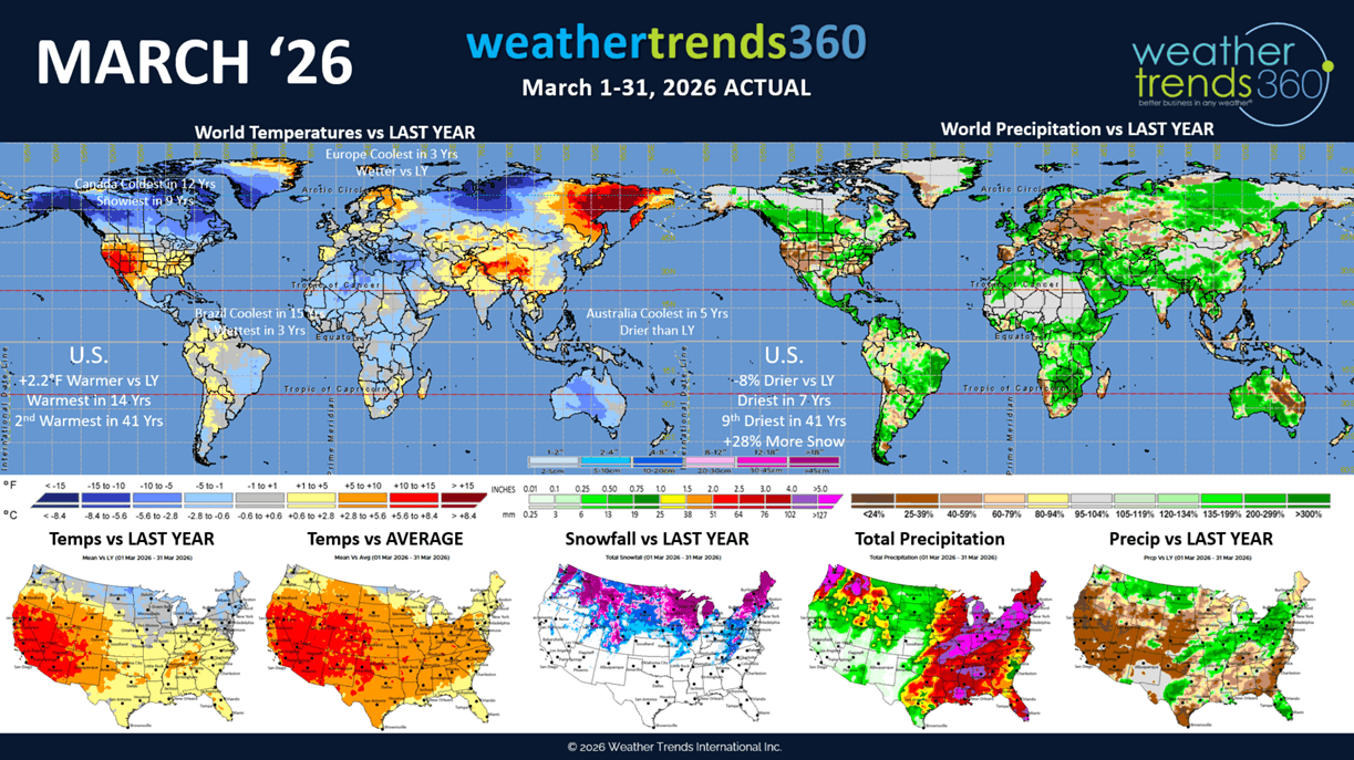
A recap of the calendar March 2026 shows the month trending +2.2F warmer than last year nationally, warmest in 14 years and 2nd warmest in 41 years. Very unusual because Canada was the coldest in 12 years and snowiest in 9 years. Rainfall was down -8% vs last year in the U.S., driest in 7 years and 9th driest in 41 years, while snowfall was up +28% vs last year. CLICK ON IMAGES FOR A LARGER VIEW

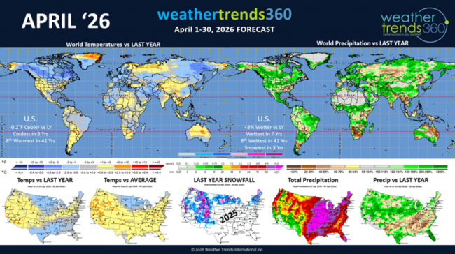
April 2026 shows the West remaining the warm spot with the North Central U.S. the cooler spot. Overall U.S. trends show temperatures slightly cooler -0.2F vs last year, coolest in 3 years, while rainfall is up +8% vs last year, wettest in 7 years and snowiest in 3 years.
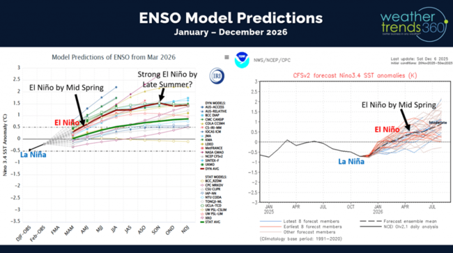
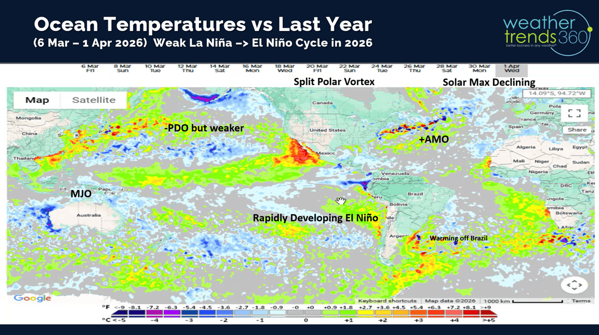
There are several major climate cycles shifting with the first being a transition to what could become a strong El Niño. This transition is very much a WET cycle approaching for the U.S.

Models show a moderate El Niño potential by Summer and borderline strong.
We've had 5 years of La Nina (colder than average Equatorial Pacific Ocean Temperatures) over the past 6 years which explains the widespread dry to drought phases across the U.S.
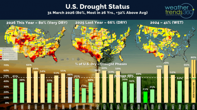
Currently a near record 80% of the U.S is in dry to drought phases, but already seeing signs that cycle is breaking down with April likely to start the wettest in 35 years.

Not surprising that wildfire acres burned are off to a very fast start trending +124% above average with 1.5M acres already burned this year. This will be a very common theme all Summer in the West until the El Niño rains quick in late Fall in the West.
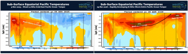
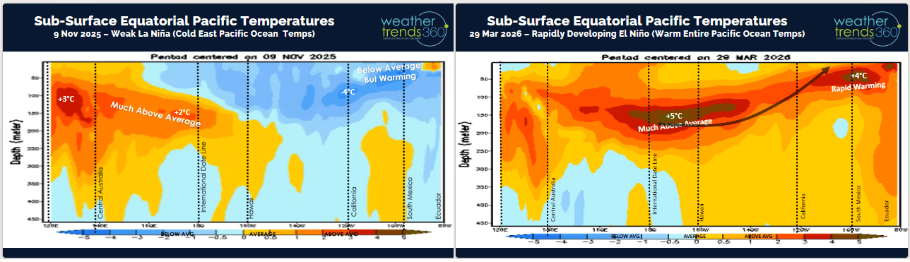
The risk of a stronger El Niño is evident by the sub-surface Equatorial Pacific Ocean temperatures that show sub-surface ocean temperatures +5C above average. This is the reason there is some buzz, maybe too much at this stage of a Super El Niño...TBD!

The other cycle shifting is the Solar Cycle 25 that has clearly peaked (2024) and now headed toward a Solar Minimum Cycle by 2030. Not uncommon after Solar Peaks to have warming oceans and wetter years. Despite the active Cycle 25, it was nowhere near as strong as the near record year in the late 1950s or way back in 1775.
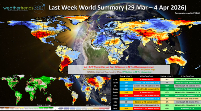
Last week (29 Mar - 4 Apr) across the World shows the U.S. trending +4.2F warmer than last year and #1 warmest in 41 years. Snowfall was -1% vs LY, least in 4 years, while rainfall was -42% drier than LY, least in 3 years, but still 8th wettest of the past 41 years. These are favorable trends for seasonal sales and store traffic, but the wet weather was a dampening factor in the Central U.S. and Northeast, the Southeast remains very dry. Canada continued to stay cold - 7th coldest in 41 years, while China was the hot spot trending 4th warmest in 41 years. Continued cool and wet in Brazil benefiting their 2nd season crops.
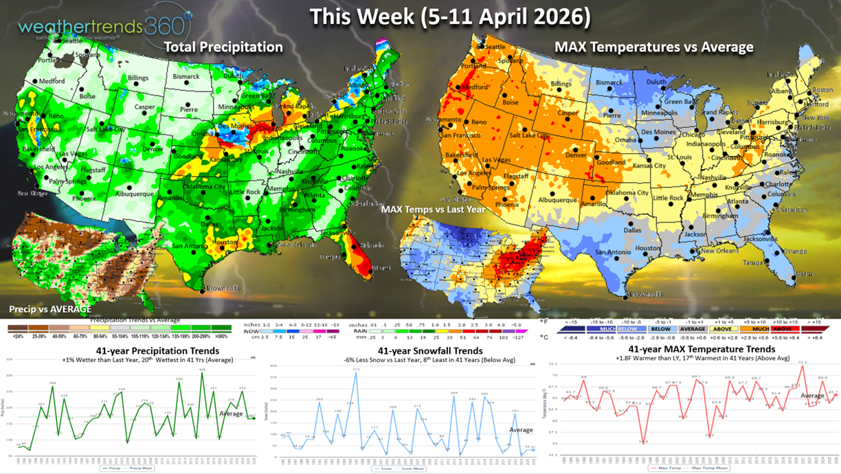
This week (5-11 Apr) across the U.S. shows a continued up and down pattern with bursts of very warm weather followed by a few days of colder weather. Overall the week trends +1.8F warmer than last year for the U.S. overall and 17th warmest of the past 41 years, so not as extreme as last week. Much colder in the North Central U.S. Rainfall up +1% with some much needed rain in the West.
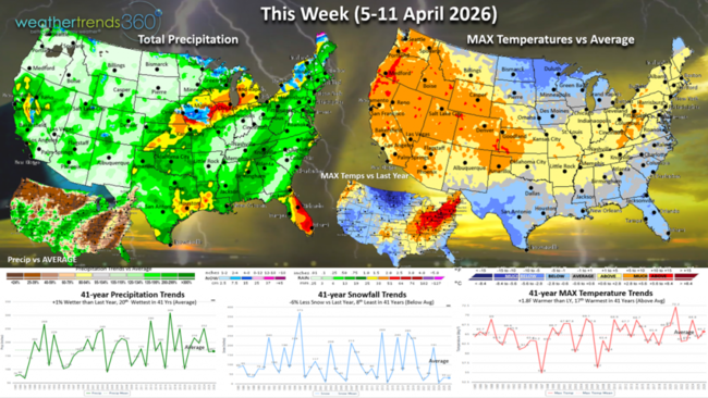
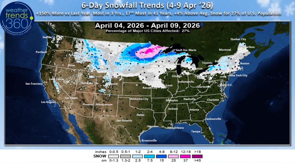
The 6-day snowfall outlook (4-9 Apr) shows Winter hanging on in the Upper Midwest and Northern Plains with more heavy snow early in the period. 27% of the U.S. will get some snow over the next 6-days.
 A strong cold front will sweep off the East Coast Easter Sunday ushering in much colder weather into the Midwest and Northeast early next week. The Polar Vortex is starting it's complete collapse, typical in Spring, but with one glancing shot for the U.S.
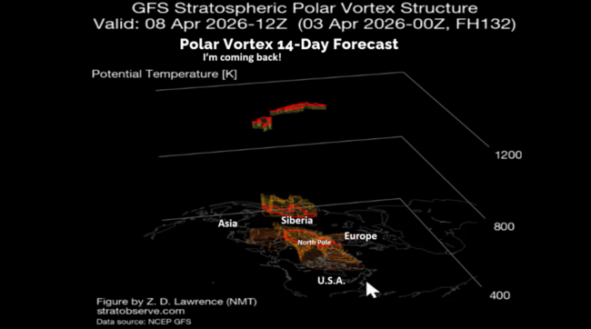
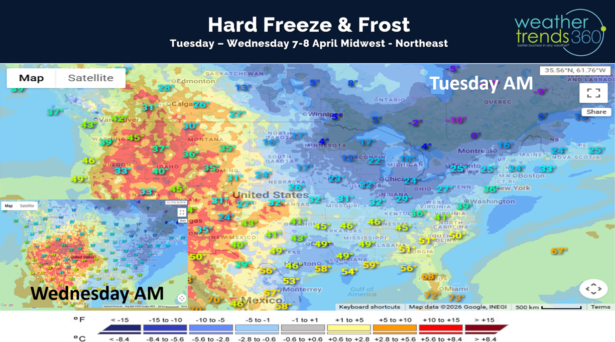
Widespread frost and hard freezes likely in these areas which will impact vegetation that has emerged too early due to the recent warm weather. Tuesday-Wednesday mornings will be the coldest days this week.

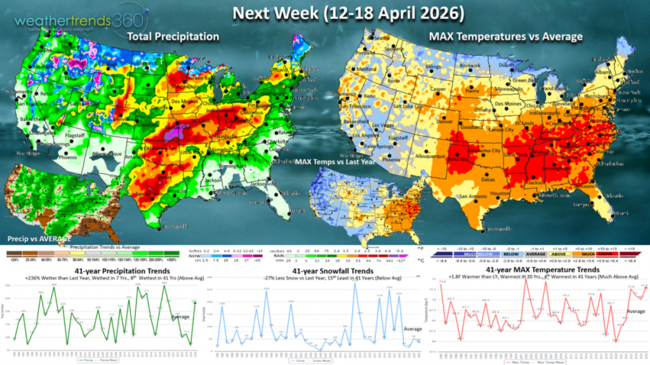
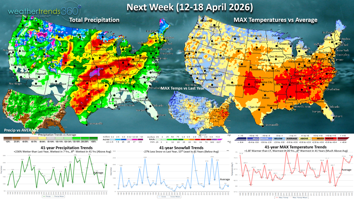
Next week (12-18 Apr) shows the heart of the warm weather shifting into the Southeast and some moderation in the West. The U.S. overall trends +1.8F warmer than last year, warmest in 20 years and 4th warmest in 41 years. Snowfall down -27% vs LY with snow mainly confined to the higher elevations of the Rockies. Rainfall way up +236% vs last year, wettest in 7 years and 8th wettest in 41 years. This is starting to show signs of the developing El Nino like pattern which will become increasingly wetter this Summer and Fall.
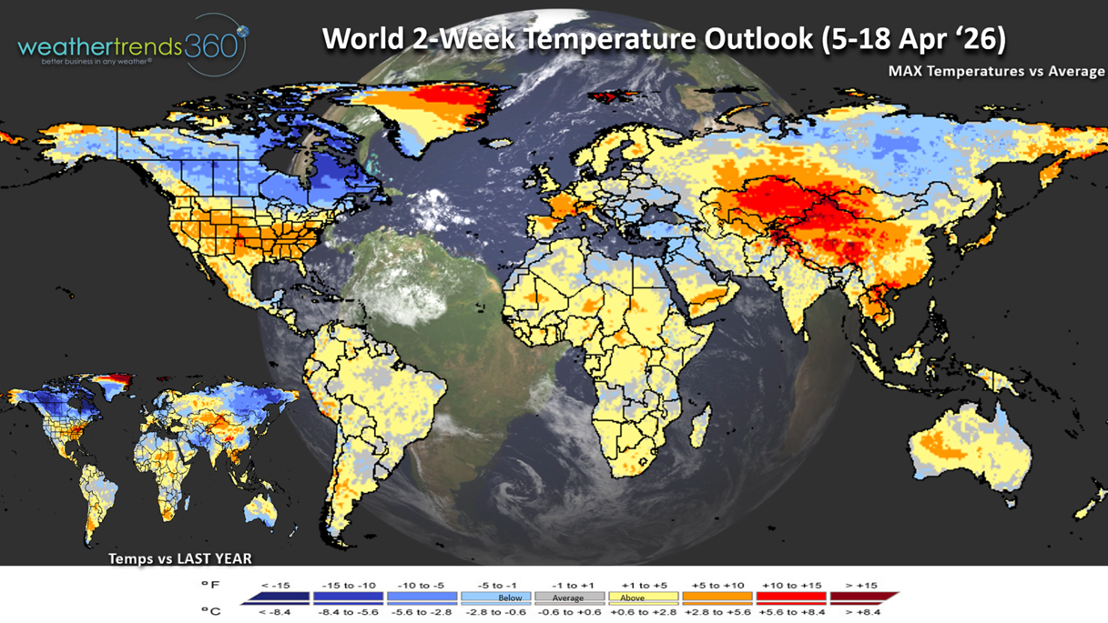
The World 2-week Temperature Outlook (5-18 Apr) shows continued warm weather in the U.S. while the cold weather stays bottled up in Canada. Central Europe and the U.K. is favorably warm, with cool conditions in the Middle East.

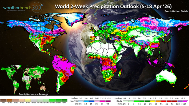
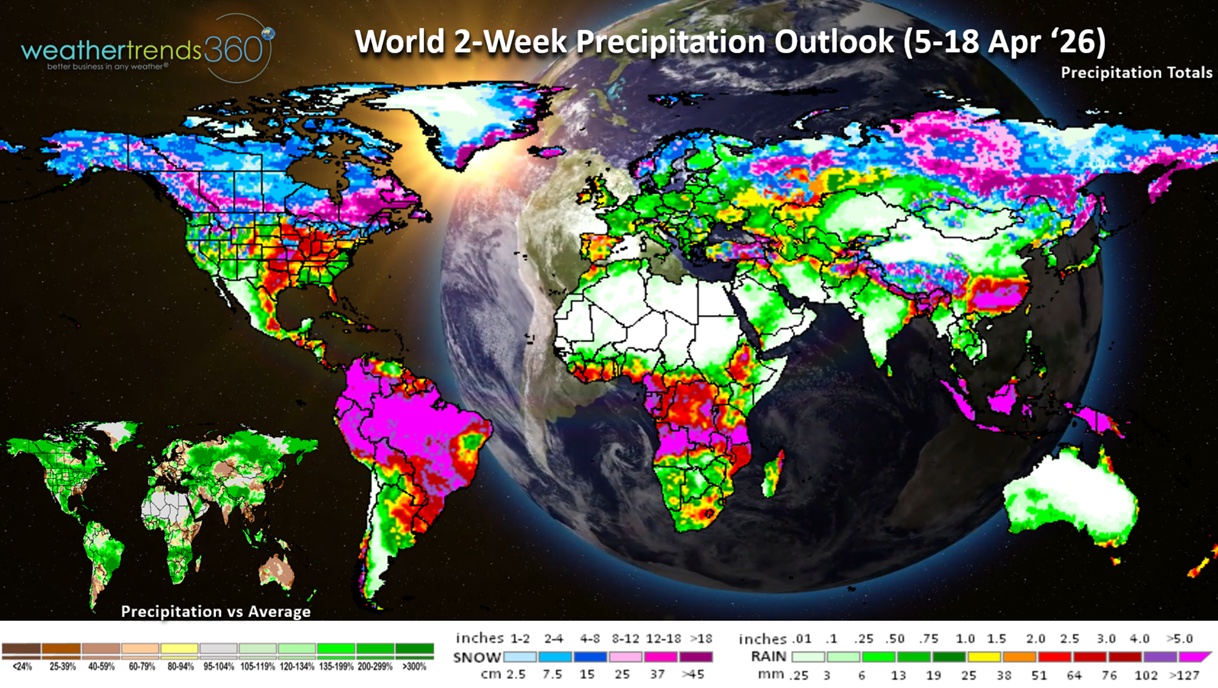
The World 2-week Precipitation Outlook (5-18 Apr) shows the stormier pattern across much of the U.S. with the Southeast remaining generally dry with expanding drought in that region. Continued very wet across Brazil benefiting their second crop which should bring near record yields.
You can get this blog/video in your email inbox every Saturday (FREE) via subscription.
Have a great week ahead, and don't forget to follow us on social media for updates: Facebook, Twitter(X), YouTube, Pinterest and Linkedin.
- Captain Kirk out (USAF Gulf War Veteran 1989-1999)
A recap of the calendar March 2026 shows the month trending +2.2F warmer than last year nationally, warmest in 14 years and 2nd warmest in 41 years. Very unusual because Canada was the coldest in 12 years and snowiest in 9 years. Rainfall was down -8% vs last year in the U.S., driest in 7 years and 9th driest in 41 years, while snowfall was up +28% vs last year. CLICK ON IMAGES FOR A LARGER VIEW
April 2026 shows the West remaining the warm spot with the North Central U.S. the cooler spot. Overall U.S. trends show temperatures slightly cooler -0.2F vs last year, coolest in 3 years, while rainfall is up +8% vs last year, wettest in 7 years and snowiest in 3 years.

There are several major climate cycles shifting with the first being a transition to what could become a strong El Niño. This transition is very much a WET cycle approaching for the U.S.
Models show a moderate El Niño potential by Summer and borderline strong.

We've had 5 years of La Nina (colder than average Equatorial Pacific Ocean Temperatures) over the past 6 years which explains the widespread dry to drought phases across the U.S.

Currently a near record 80% of the U.S is in dry to drought phases, but already seeing signs that cycle is breaking down with April likely to start the wettest in 35 years.
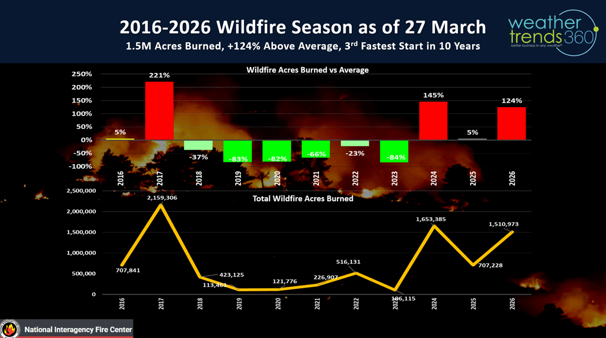
Not surprising that wildfire acres burned are off to a very fast start trending +124% above average with 1.5M acres already burned this year. This will be a very common theme all Summer in the West until the El Niño rains quick in late Fall in the West.
The risk of a stronger El Niño is evident by the sub-surface Equatorial Pacific Ocean temperatures that show sub-surface ocean temperatures +5C above average. This is the reason there is some buzz, maybe too much at this stage of a Super El Niño...TBD!
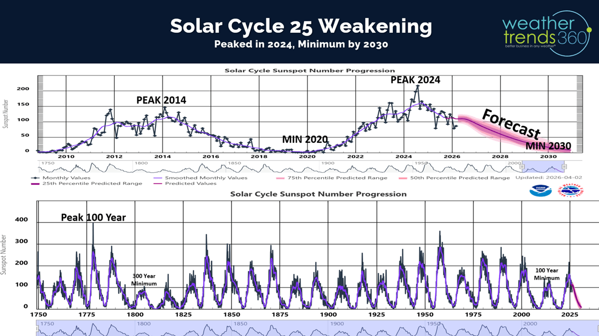
The other cycle shifting is the Solar Cycle 25 that has clearly peaked (2024) and now headed toward a Solar Minimum Cycle by 2030. Not uncommon after Solar Peaks to have warming oceans and wetter years. Despite the active Cycle 25, it was nowhere near as strong as the near record year in the late 1950s or way back in 1775.

Last week (29 Mar - 4 Apr) across the World shows the U.S. trending +4.2F warmer than last year and #1 warmest in 41 years. Snowfall was -1% vs LY, least in 4 years, while rainfall was -42% drier than LY, least in 3 years, but still 8th wettest of the past 41 years. These are favorable trends for seasonal sales and store traffic, but the wet weather was a dampening factor in the Central U.S. and Northeast, the Southeast remains very dry. Canada continued to stay cold - 7th coldest in 41 years, while China was the hot spot trending 4th warmest in 41 years. Continued cool and wet in Brazil benefiting their 2nd season crops.
This week (5-11 Apr) across the U.S. shows a continued up and down pattern with bursts of very warm weather followed by a few days of colder weather. Overall the week trends +1.8F warmer than last year for the U.S. overall and 17th warmest of the past 41 years, so not as extreme as last week. Much colder in the North Central U.S. Rainfall up +1% with some much needed rain in the West.
The 6-day snowfall outlook (4-9 Apr) shows Winter hanging on in the Upper Midwest and Northern Plains with more heavy snow early in the period. 27% of the U.S. will get some snow over the next 6-days.
A strong cold front will sweep off the East Coast Easter Sunday ushering in much colder weather into the Midwest and Northeast early next week. The Polar Vortex is starting it's complete collapse, typical in Spring, but with one glancing shot for the U.S.
Widespread frost and hard freezes likely in these areas which will impact vegetation that has emerged too early due to the recent warm weather. Tuesday-Wednesday mornings will be the coldest days this week.
Next week (12-18 Apr) shows the heart of the warm weather shifting into the Southeast and some moderation in the West. The U.S. overall trends +1.8F warmer than last year, warmest in 20 years and 4th warmest in 41 years. Snowfall down -27% vs LY with snow mainly confined to the higher elevations of the Rockies. Rainfall way up +236% vs last year, wettest in 7 years and 8th wettest in 41 years. This is starting to show signs of the developing El Nino like pattern which will become increasingly wetter this Summer and Fall.
The World 2-week Temperature Outlook (5-18 Apr) shows continued warm weather in the U.S. while the cold weather stays bottled up in Canada. Central Europe and the U.K. is favorably warm, with cool conditions in the Middle East.
The World 2-week Precipitation Outlook (5-18 Apr) shows the stormier pattern across much of the U.S. with the Southeast remaining generally dry with expanding drought in that region. Continued very wet across Brazil benefiting their second crop which should bring near record yields.
You can get this blog/video in your email inbox every Saturday (FREE) via subscription.
Have a great week ahead, and don't forget to follow us on social media for updates: Facebook, Twitter(X), YouTube, Pinterest and Linkedin.
- Captain Kirk out (USAF Gulf War Veteran 1989-1999)