wt360 Weather Brief 28 Jun '26 Coldest in 22 Year to the Hottest in 14 Years
Captain's Log
28 June '26: Happy Saturday!
No video this week.
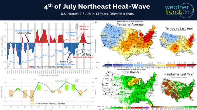
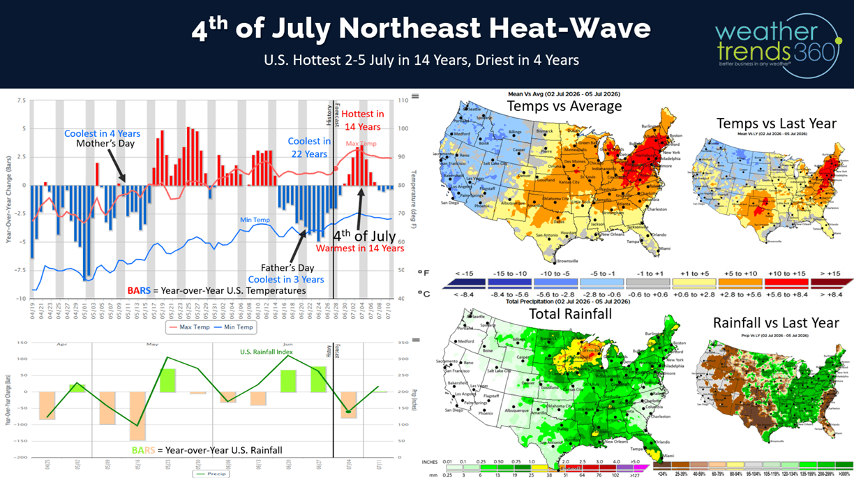
What an amazing change with the U.S. going from the coolest in 22 years last week to the hottest in 14 years this week of 4th of July. The Northeast will get a major heatwave with 100F temps for several days midweek with a gradual cooling trend next weekend. CLICK ON IMAGES FOR A LARGER VIEW.
Applying our Power of 1 Degree seasonal sales trends vs weather trends for the Northeast where it will trend +8F hotter than last year, categories like AC could see +120% YOY sales gains.
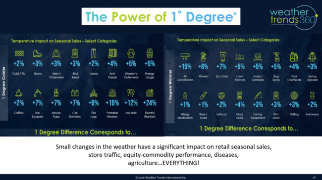
Auto Batteries fail in extreme heat with +56% YOY gains possible, Pool Chemicals up +32% and cold beverage sales up +8% to +16. The West will actually trend down with much cooler weather.
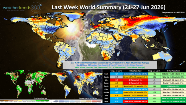
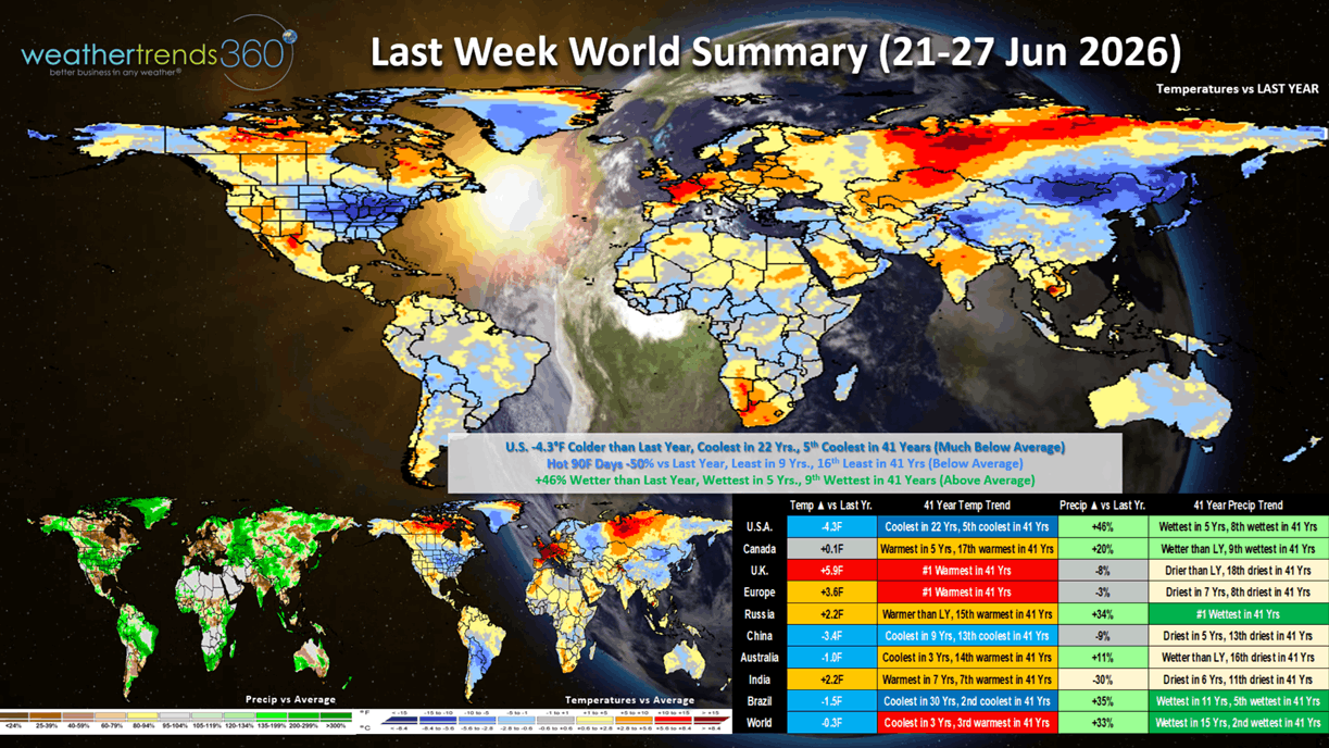
Last week (21-27 June) across the World shows the U.S. trending a very significant -4.3F cooler than last year, coolest in 22 years and 5th coolest in 41 years with much below average national temperatures. Hot 90F days were down -50% vs last year, least in 9 years and 16th least in 41 years, while rainfall was up +46% vs LY, wettest in 5 years and 9th wettest in 41 years. These were very negative trends for Summer seasonal merchandise. Not so in the U.K. and Europe where it was record #1 hottest in over 41 years and generally dry. Exceptionally cool and wet in Brazil trending the coolest in 30 years and wettest in 11 years favoring their seasonal crops.
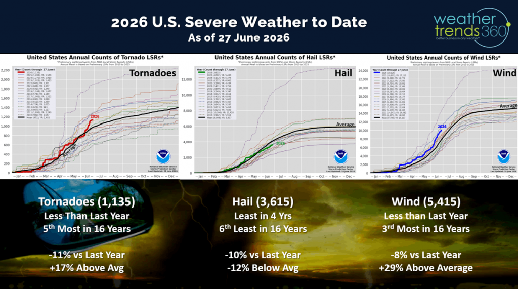
Severe weather, especially tornadoes, made a big jump with the cooler/wetter pattern and now trending +17% above average. That's still down -11% vs last year but 5th most in 16 years. Hail is trending least in 4 years, while high wind events are down vs last year but still 3rd most in 16 years.
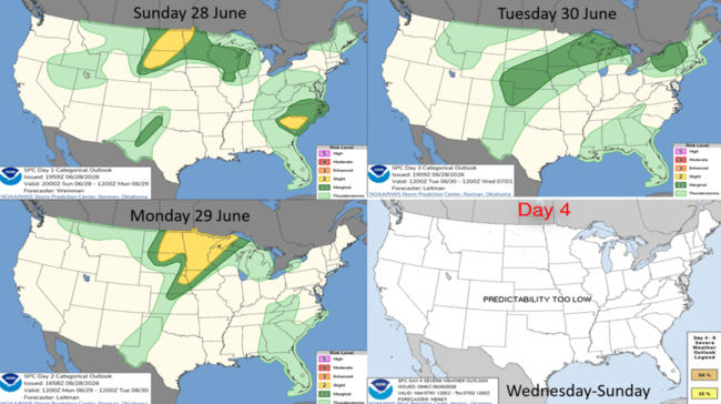
 The 4-day severe weather outlook shows the Upper Midwest the highest risk region for more severe weather.
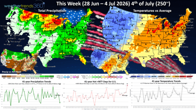
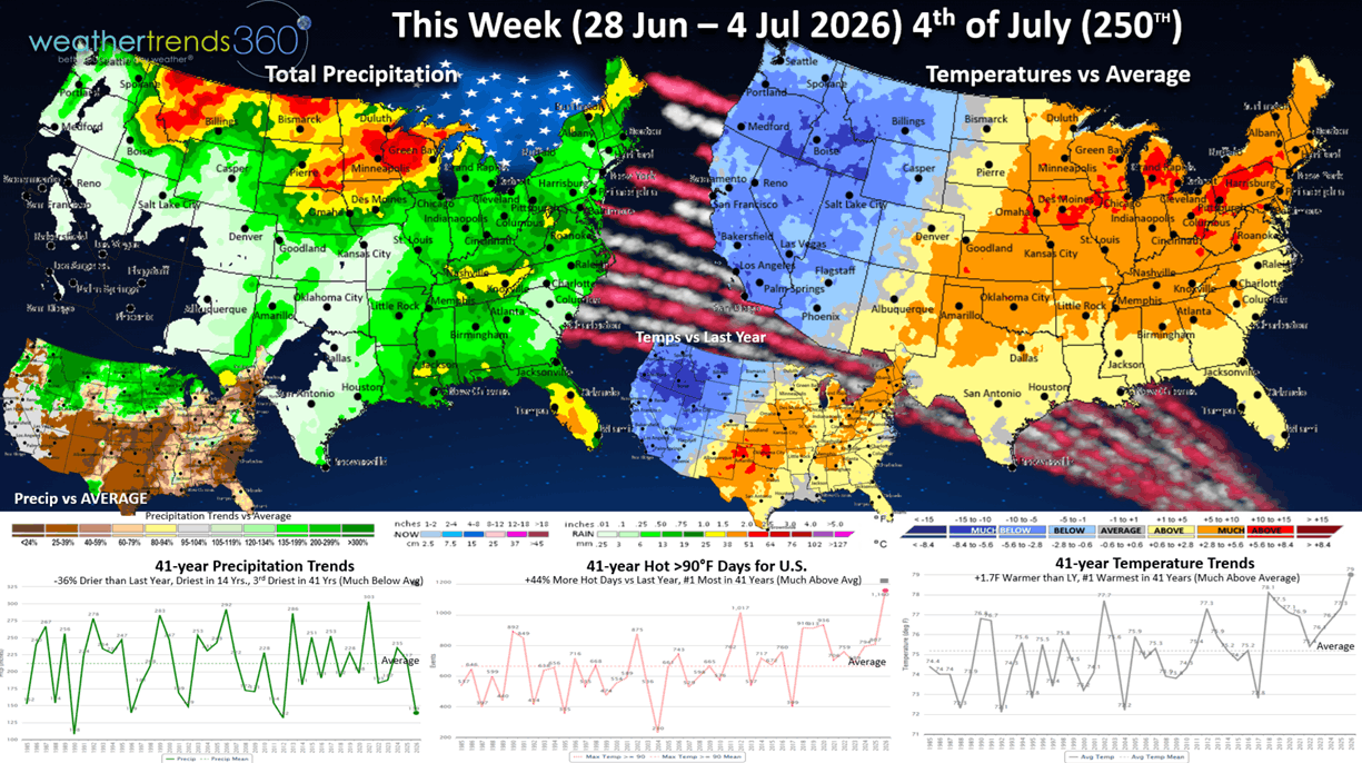
This Week (28 Jun - 4 Jul) - 250th Independence Day - is making a wholesale change from last week with the major heatwave surging U.S. temperatures +1.7F higher than last year but #1 hottest in over 41 years. Hot 90F days also surging +44% vs last year and #1 most in 41 years. Rainfall is down -36% vs LY, driest in 14 years and 3rd driest in 41 years. Expect a huge pent-up demand surge in almost all Summer seasonal categories, especially AC, fans, cold beverages, pool supplies, water toys, auto batteries and suncare.
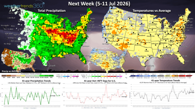
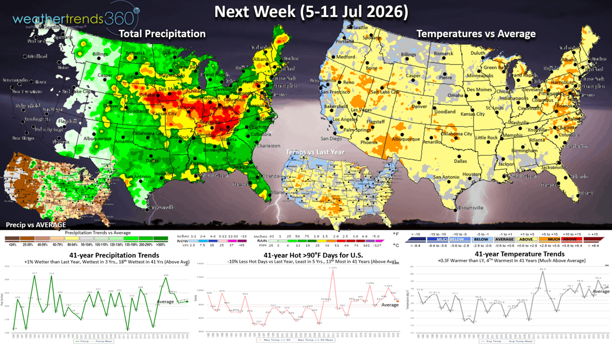
Next week (5-11 Jul) shows the extreme heat backing off, but the West will warm up dramatically. The U.S. overall trends +0.3F warmer than last year and 4th warmest of the past 41 years, but hot 90F days are down -10% vs LY, least in 5 years and 13th most in 41 years. Rainfall is up slightly +1% vs LY, wettest in 3 years and 18th wettest in 41 years with a stormier pattern. The U.S. Corn Belt has been the big winner for rain this year and likely to bring record crop yields over last year's record.
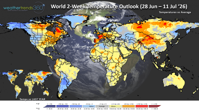
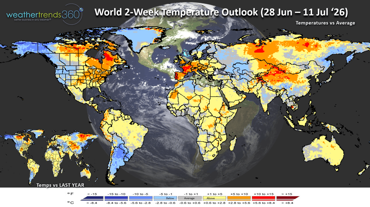
The World 2-week Temperature Outlook (28 Jun - 11 Jul) shows very hot conditions in Eastern Canada, Eastern U.S. and much of Europe. Cool for Western North America and the Southern half of South America.
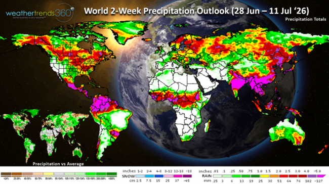
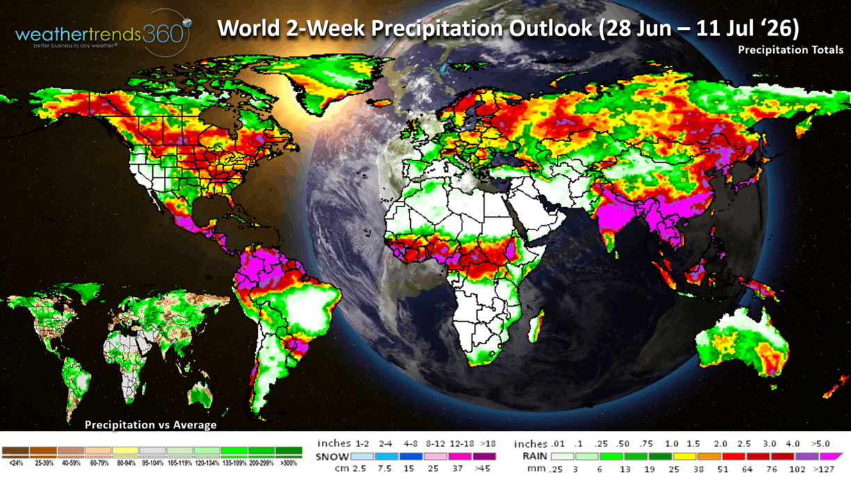
The World 2-week Precipitation Outlook (28 Jun - 11 Jul) is dry for the Southern half of the U.S. and wetter for the North. Generally wet across most of Canada. Continued very dry in Europe.
You can get this blog in your email inbox every weekend (FREE) via subscription.
Have a great week ahead, and don't forget to follow us on social media for updates: Facebook, Twitter(X), YouTube, Pinterest and Linkedin.
- Captain Kirk out (USAF Gulf War Veteran 1989-1999)
No video this week.
What an amazing change with the U.S. going from the coolest in 22 years last week to the hottest in 14 years this week of 4th of July. The Northeast will get a major heatwave with 100F temps for several days midweek with a gradual cooling trend next weekend. CLICK ON IMAGES FOR A LARGER VIEW.
Applying our Power of 1 Degree seasonal sales trends vs weather trends for the Northeast where it will trend +8F hotter than last year, categories like AC could see +120% YOY sales gains.
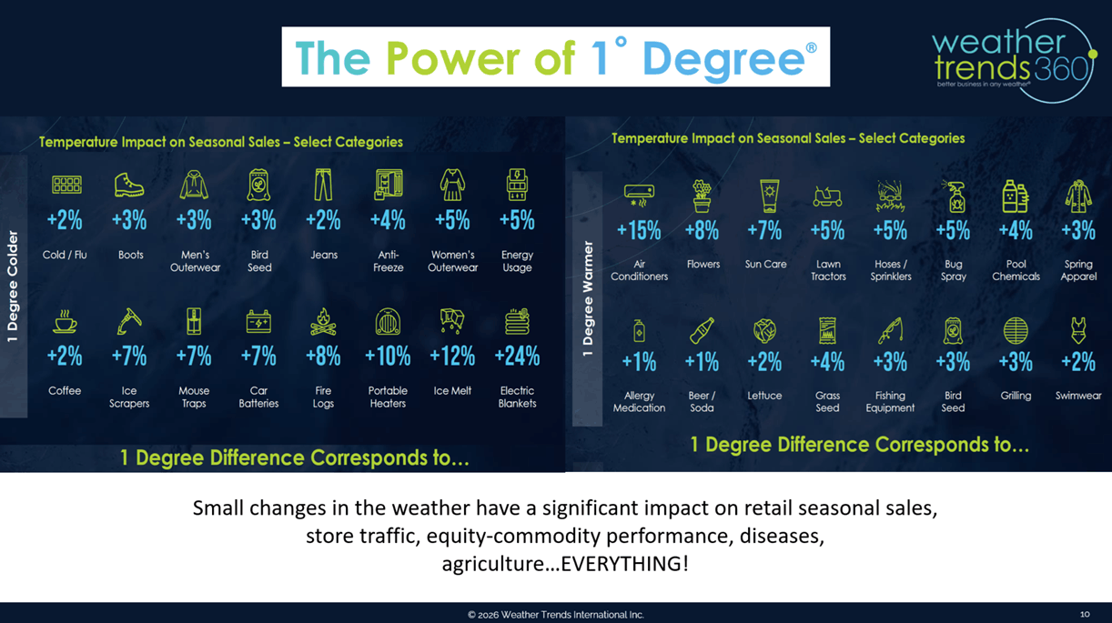
Auto Batteries fail in extreme heat with +56% YOY gains possible, Pool Chemicals up +32% and cold beverage sales up +8% to +16. The West will actually trend down with much cooler weather.
Last week (21-27 June) across the World shows the U.S. trending a very significant -4.3F cooler than last year, coolest in 22 years and 5th coolest in 41 years with much below average national temperatures. Hot 90F days were down -50% vs last year, least in 9 years and 16th least in 41 years, while rainfall was up +46% vs LY, wettest in 5 years and 9th wettest in 41 years. These were very negative trends for Summer seasonal merchandise. Not so in the U.K. and Europe where it was record #1 hottest in over 41 years and generally dry. Exceptionally cool and wet in Brazil trending the coolest in 30 years and wettest in 11 years favoring their seasonal crops.
Severe weather, especially tornadoes, made a big jump with the cooler/wetter pattern and now trending +17% above average. That's still down -11% vs last year but 5th most in 16 years. Hail is trending least in 4 years, while high wind events are down vs last year but still 3rd most in 16 years.
The 4-day severe weather outlook shows the Upper Midwest the highest risk region for more severe weather.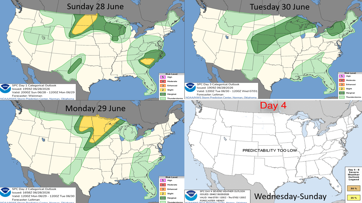
This Week (28 Jun - 4 Jul) - 250th Independence Day - is making a wholesale change from last week with the major heatwave surging U.S. temperatures +1.7F higher than last year but #1 hottest in over 41 years. Hot 90F days also surging +44% vs last year and #1 most in 41 years. Rainfall is down -36% vs LY, driest in 14 years and 3rd driest in 41 years. Expect a huge pent-up demand surge in almost all Summer seasonal categories, especially AC, fans, cold beverages, pool supplies, water toys, auto batteries and suncare.
Next week (5-11 Jul) shows the extreme heat backing off, but the West will warm up dramatically. The U.S. overall trends +0.3F warmer than last year and 4th warmest of the past 41 years, but hot 90F days are down -10% vs LY, least in 5 years and 13th most in 41 years. Rainfall is up slightly +1% vs LY, wettest in 3 years and 18th wettest in 41 years with a stormier pattern. The U.S. Corn Belt has been the big winner for rain this year and likely to bring record crop yields over last year's record.
The World 2-week Temperature Outlook (28 Jun - 11 Jul) shows very hot conditions in Eastern Canada, Eastern U.S. and much of Europe. Cool for Western North America and the Southern half of South America.
The World 2-week Precipitation Outlook (28 Jun - 11 Jul) is dry for the Southern half of the U.S. and wetter for the North. Generally wet across most of Canada. Continued very dry in Europe.
You can get this blog in your email inbox every weekend (FREE) via subscription.
Have a great week ahead, and don't forget to follow us on social media for updates: Facebook, Twitter(X), YouTube, Pinterest and Linkedin.
- Captain Kirk out (USAF Gulf War Veteran 1989-1999)