wt360 Weather Brief 28 Feb '26 Wettest Start to March in 41+ Years!
Captain's Log
28 Feb 2026: Happy Saturday from wt360 HQ in Bethlehem PA
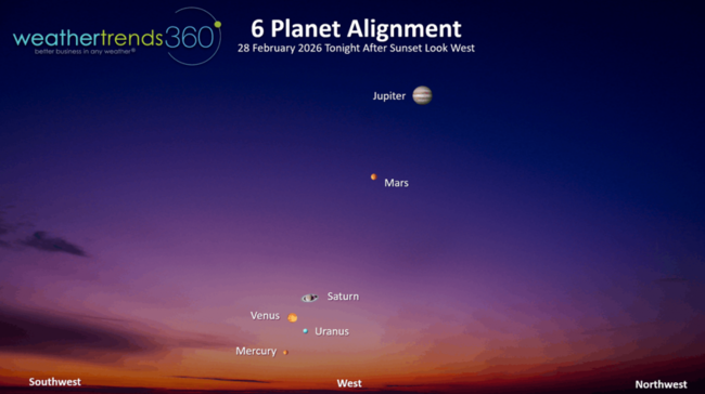
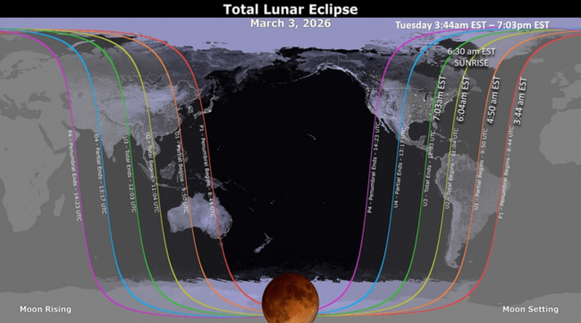
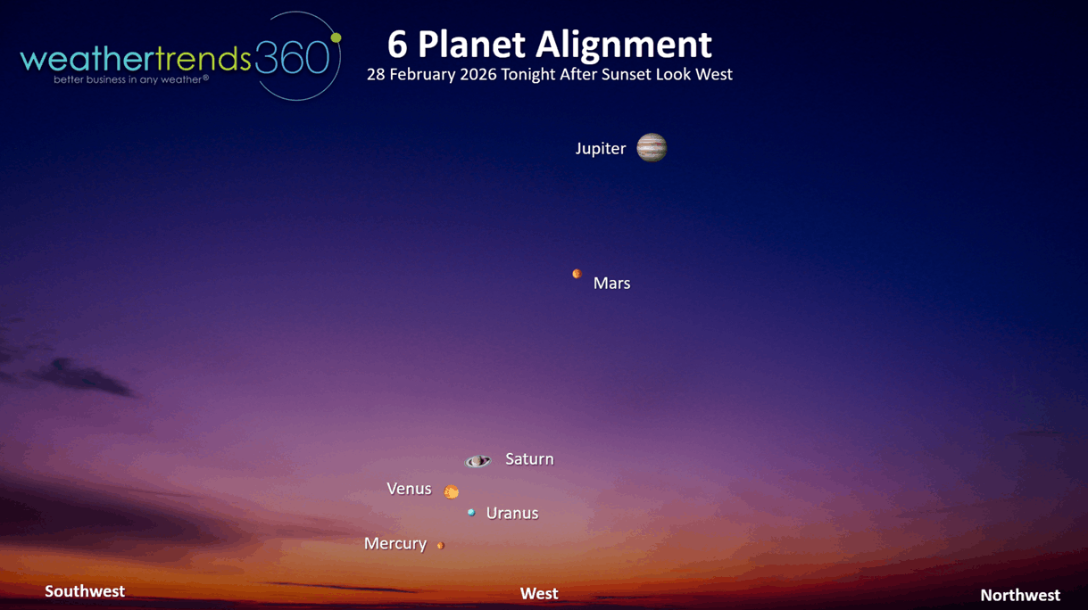
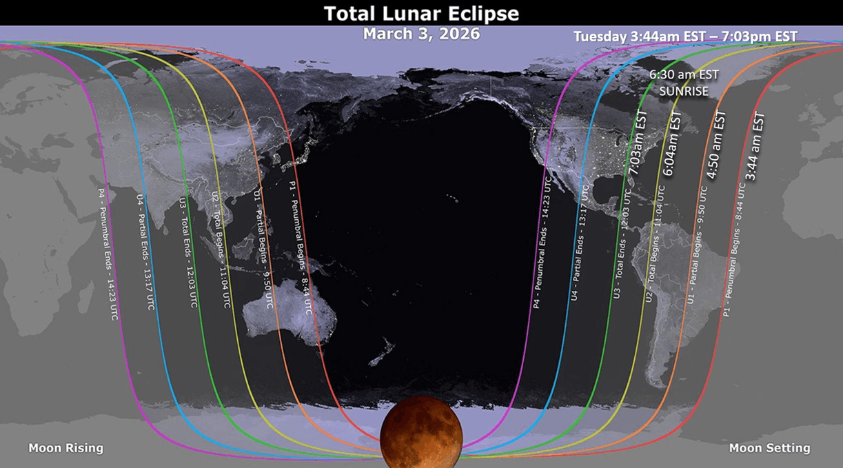
A lot of cool things to see up in the sky the next few nights from a planetary alignment tonight after sunset, a streaming Falcon 9 rocket up the East Coast Sunday evening and a lunar eclipse Tuesday pre-dawn. CLICK ON IMAGES FOR A LARGER VIEW
Today's wt360 AI question is how did Winter '25-'26 trend and how accurate was the wt360 year-ahead forecast for Winter.
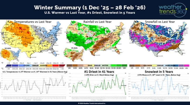
While the East Coast was frigid and snowy, the U.S. overall trended +1.3F warmer than last year and 14th warmest of the past 41 years, but a tale of two halves - warm West, cold East. Rainfall was down -19% and the #1 driest in over 41 years, while snowfall was up +5% vs last year, most in 5 years and 18th least of the past 41 years.
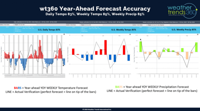
The wt360 YEAR-AHEAD weekly U.S. forecast was 85% correct on weekly temperature, 85% correct on weekly rainfall trends and 83% correct on daily weather trends. The bars are year ahead YOY forecast, the dotted line is actual. Overall a pretty good outlook.
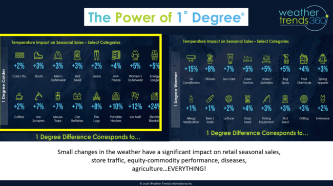
If you can get the weather right a year-ahead at a granular weekly level, combined with the wt360 Power of 1 Degree technology on seasonal sales, you can get a pretty good estimate of how category sales, store traffic, equity performance, etc. will trend in the year-ahead.
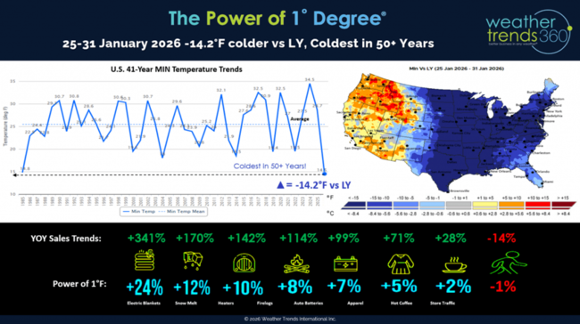
The last week of Q1 (late January Polar Vortex) was a good example of just how impactful the weather can be on everything we buy.
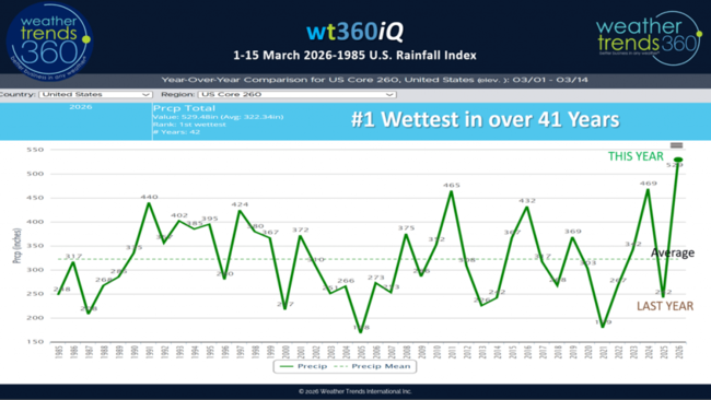
Now asking the wt360 robot about March rainfall shows the #1 wettest start to the month in over 41 years with a very storm pattern. A wholesale change from the very dry start last year. Store traffic gets hurt with wet weather. This combined with a big warm surge will very likely lead to some ice jams on rivers in the Great Lakes, Ohio Valley and especially the Northeast - these can create major floods if they pile up near bridges or topographic features. SOMETHING TO WATCH the next few weeks!
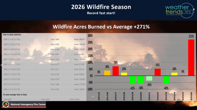
While we don't need floods (this will become a bigger theme in 2026) we do need the rain to put out the fires which are off to the fastest start in over a decade. Wildfire acres burned to date are off the scale trending +271% above average!
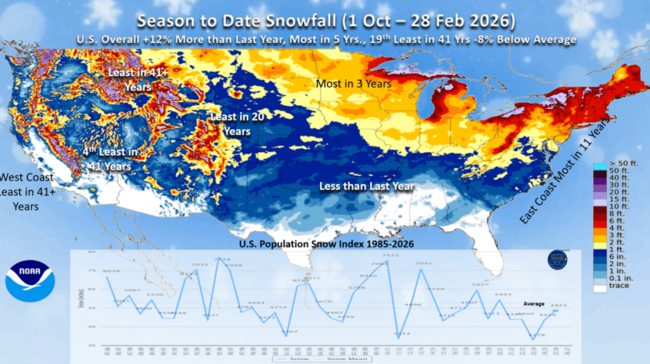
Season-to-date snowfall after the big Nor'easter last weekend is now trending up +12% nationally, most in 5 years but 19th least of the past 41 years. The East Coast was clearly the big winner this year, the Western U.S. way down.

Snow cover this morning is similar to last year with only 17% of the U.S. covered in snow from the Upper Midwest to New Jersey.
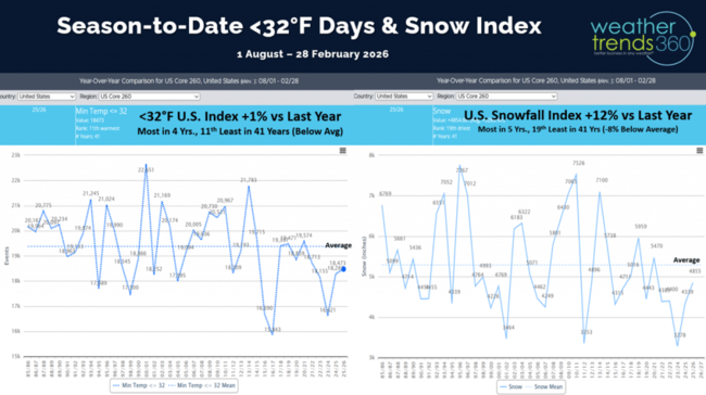
The cold day index shows the U.S. trending +1% over last year but still 11th least in 41 years.
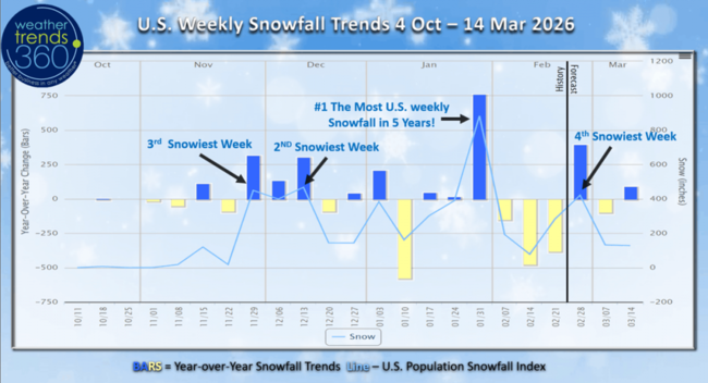
Weekly snowfall trends show the #1 snowiest week in over 5 years will remain the late January period, #2 was in middle December, #3 the end of November and this past week #4 despite the record setting Nor'easter storm.
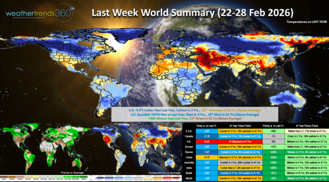
Last week (22-28 Feb) across the World shows the U.S. trending -4.9F colder than last year, coldest in 3 years but still 13th warmest in 41 years. Snowfall was way up +927% over last year, most in 3 years and 15th most in 41 years, while rainfall was up +48% vs LY but still 11th driest of the past 41 years. All three trends are generally unfavorable for YOY sales trends as warmer/drier is ideal for higher store traffic. Canada and Russia were the really cold spots, while the U.K. had the biggest change toward very warm weather. Many areas around the World have turned much wetter, a sign El Nino is taking shape.
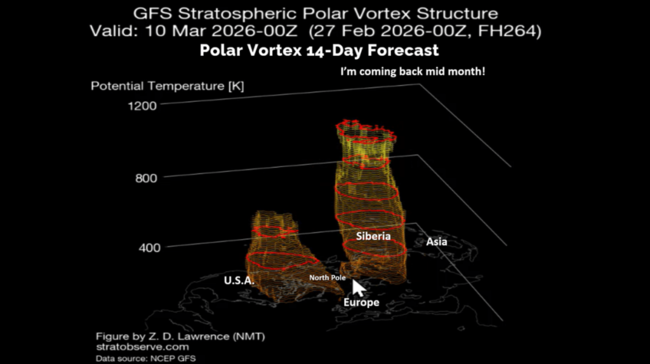
The Polar Vortex is about to split in two (very rare) and it appears one chunk will head toward Siberia and another toward North America. This sets the stage for a colder latter half of March in the U.S.
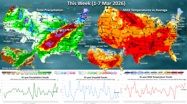
This week (1-7 March) across the U.S. trends +5.9F warmer than last year, warmest in 34 years and 2nd warmest in 41 years. Snowfall down -41% vs LY and 9th least in 41 years, while rainfall is up +30% vs LY and 4th wettest in 41 years. The warmth is good, the rain is not for overall seasonal sales.
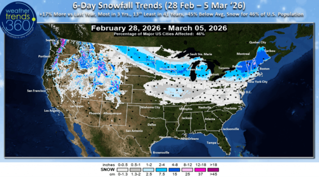
The 6-day snowfall outlook shows a Clipper-like system bringing some light to moderate snow to the Upper Midwest and into the Northeast. The 6-day (28 Feb - 5 Mar) snowfall trends +17% more than LY, most in 3 years with 46% of the U.S. population getting some snow.
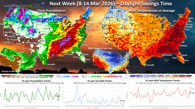
Next week (8-14 March) is the start of Daylight Savings Time and starting to see the potential for a glancing shot of the Polar Vortex at the end of this week. Prior to that, the week overall trends -2.7F colder than last year, coolest in 3 years but 6th warmest of the past 41 years. Snowfall up +249% vs LY, most in 3 years, while rainfall is way up +293% vs LY, most in 10 years and 2nd wettest in 41 years. This is a bigger negative for store traffic and especially lawn and garden categories.
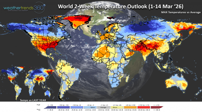
The World 2-week (1-14 March) Temperature outlook shows warmer in the U.S. and Europe, coder Canada and Russia and very hot in the Middle East - Asia.

The World 2-week (1-14 March) Precipitation outlook shows the very stormy U.S. pattern and continued wet across South America, but very dry in Europe.
You can get this blog/video in your email inbox every Saturday (FREE) via subscription.
Have a great week ahead, and don't forget to follow us on social media for updates: Facebook, Twitter(X), YouTube, Pinterest and Linkedin.
- Captain Kirk out (USAF Gulf War Veteran 1989-1999)
A lot of cool things to see up in the sky the next few nights from a planetary alignment tonight after sunset, a streaming Falcon 9 rocket up the East Coast Sunday evening and a lunar eclipse Tuesday pre-dawn. CLICK ON IMAGES FOR A LARGER VIEW
Today's wt360 AI question is how did Winter '25-'26 trend and how accurate was the wt360 year-ahead forecast for Winter.

While the East Coast was frigid and snowy, the U.S. overall trended +1.3F warmer than last year and 14th warmest of the past 41 years, but a tale of two halves - warm West, cold East. Rainfall was down -19% and the #1 driest in over 41 years, while snowfall was up +5% vs last year, most in 5 years and 18th least of the past 41 years.
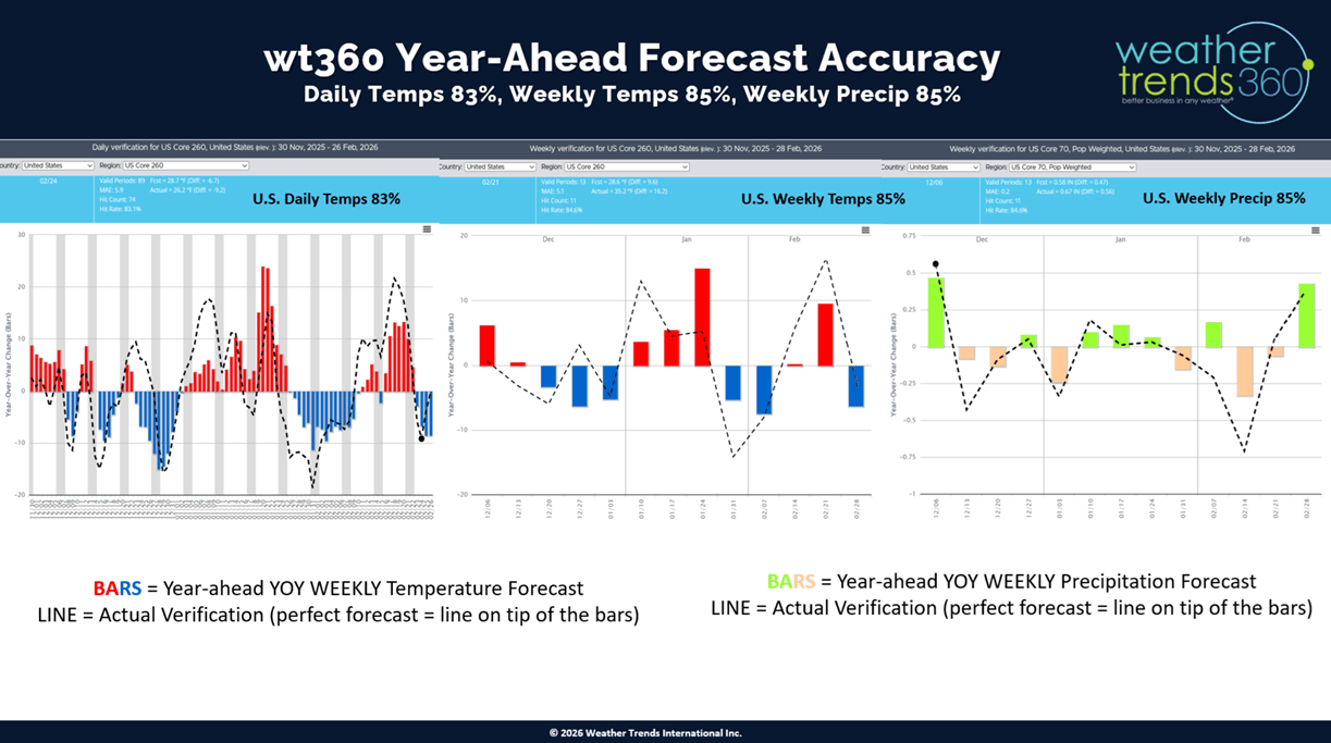
The wt360 YEAR-AHEAD weekly U.S. forecast was 85% correct on weekly temperature, 85% correct on weekly rainfall trends and 83% correct on daily weather trends. The bars are year ahead YOY forecast, the dotted line is actual. Overall a pretty good outlook.

If you can get the weather right a year-ahead at a granular weekly level, combined with the wt360 Power of 1 Degree technology on seasonal sales, you can get a pretty good estimate of how category sales, store traffic, equity performance, etc. will trend in the year-ahead.

The last week of Q1 (late January Polar Vortex) was a good example of just how impactful the weather can be on everything we buy.
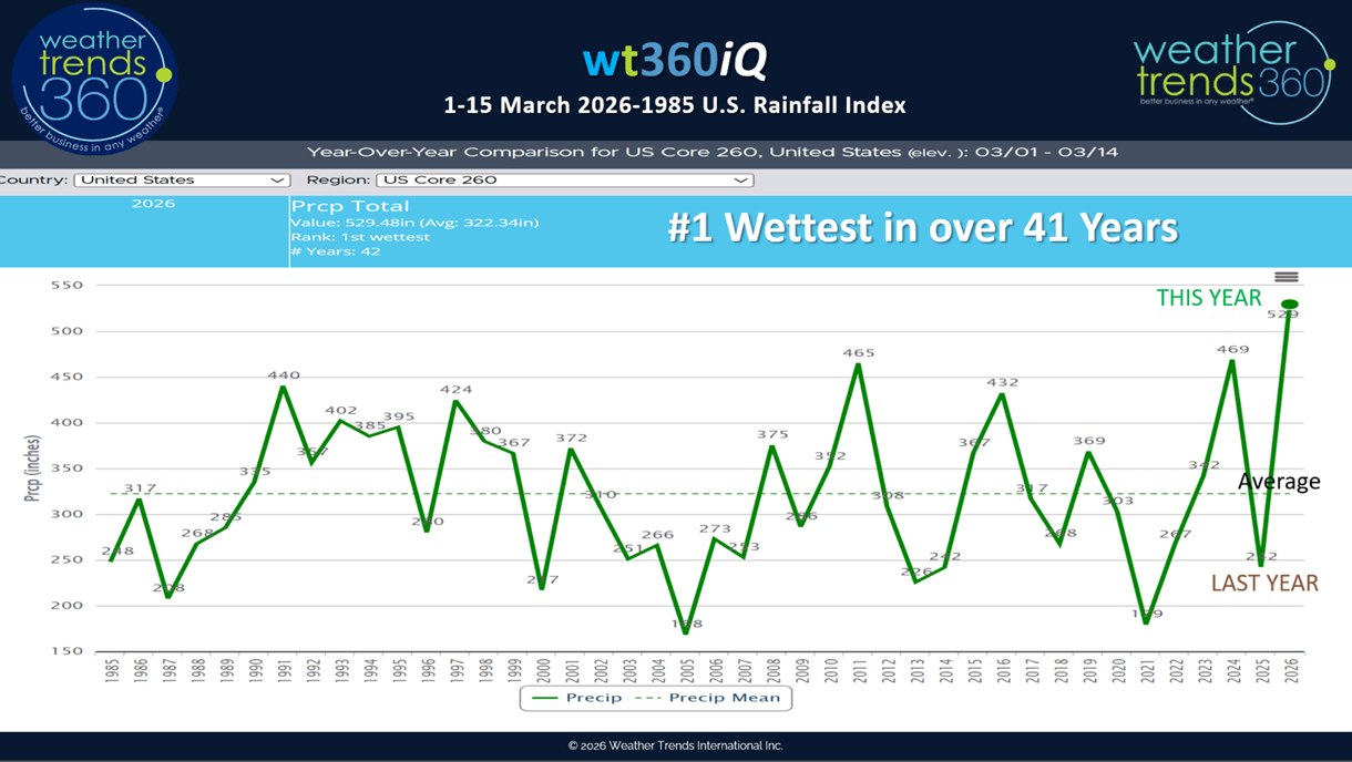
Now asking the wt360 robot about March rainfall shows the #1 wettest start to the month in over 41 years with a very storm pattern. A wholesale change from the very dry start last year. Store traffic gets hurt with wet weather. This combined with a big warm surge will very likely lead to some ice jams on rivers in the Great Lakes, Ohio Valley and especially the Northeast - these can create major floods if they pile up near bridges or topographic features. SOMETHING TO WATCH the next few weeks!

While we don't need floods (this will become a bigger theme in 2026) we do need the rain to put out the fires which are off to the fastest start in over a decade. Wildfire acres burned to date are off the scale trending +271% above average!
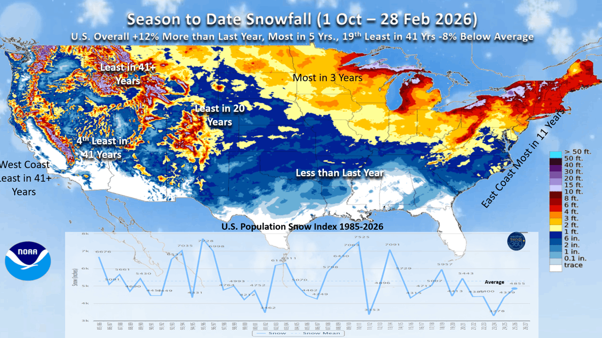
Season-to-date snowfall after the big Nor'easter last weekend is now trending up +12% nationally, most in 5 years but 19th least of the past 41 years. The East Coast was clearly the big winner this year, the Western U.S. way down.
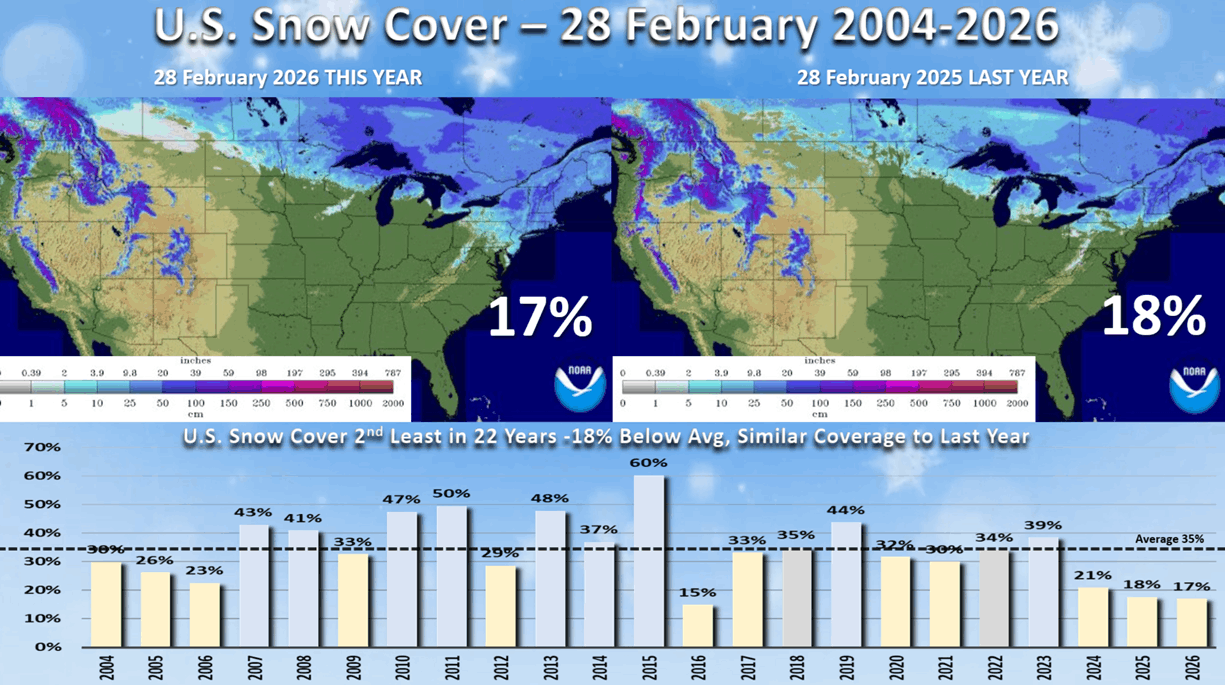
Snow cover this morning is similar to last year with only 17% of the U.S. covered in snow from the Upper Midwest to New Jersey.
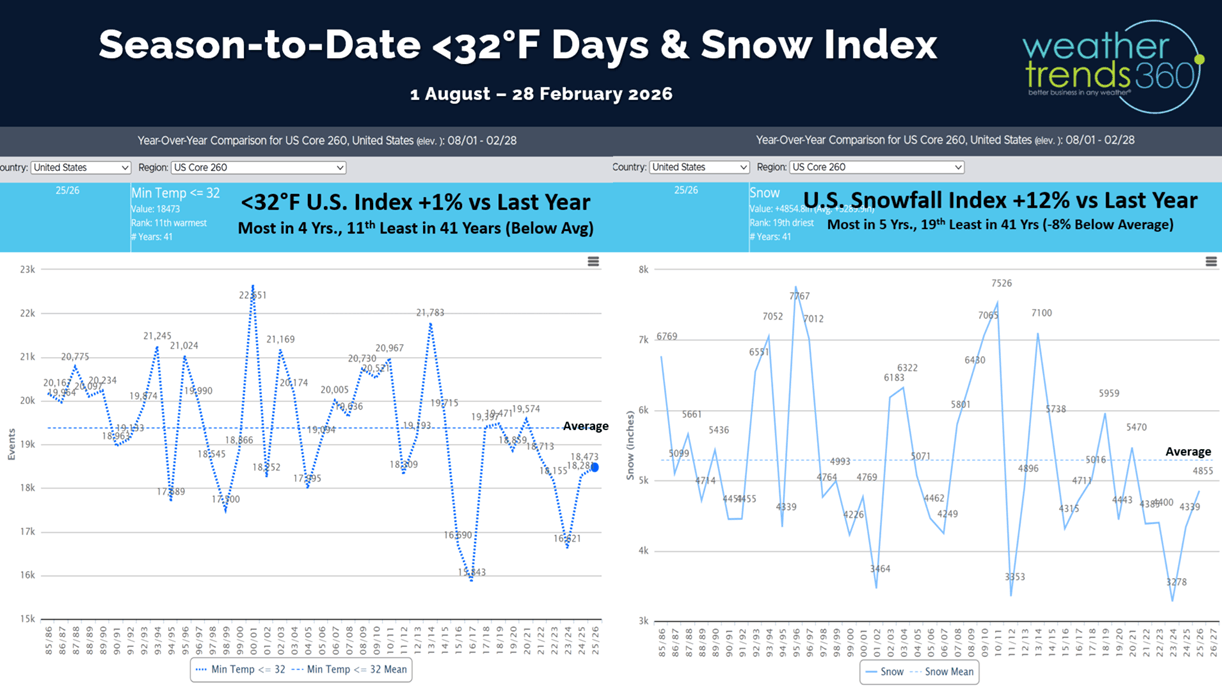
The cold day index shows the U.S. trending +1% over last year but still 11th least in 41 years.

Weekly snowfall trends show the #1 snowiest week in over 5 years will remain the late January period, #2 was in middle December, #3 the end of November and this past week #4 despite the record setting Nor'easter storm.
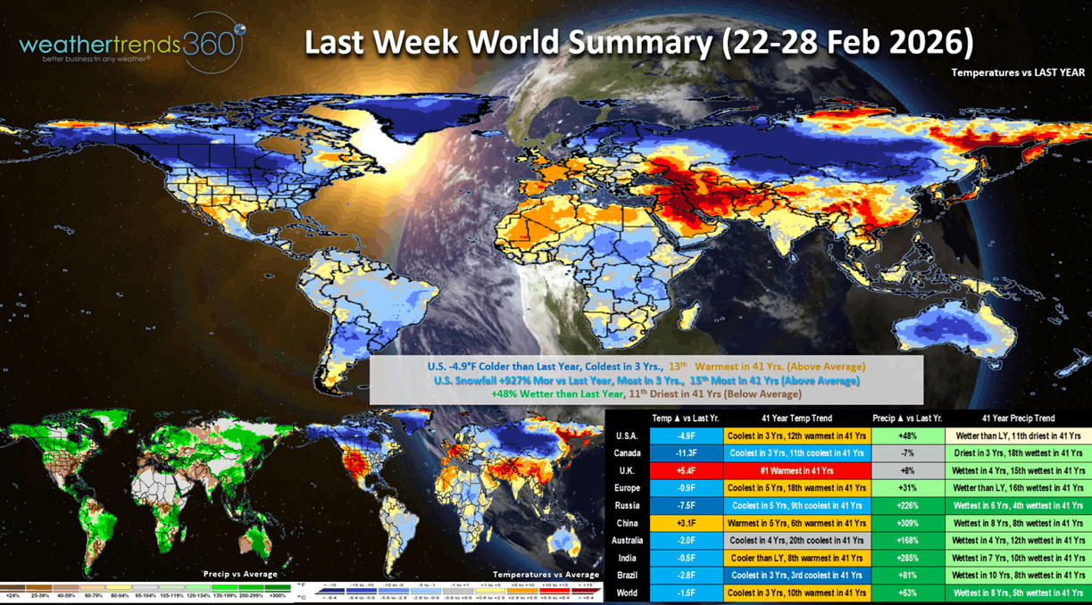
Last week (22-28 Feb) across the World shows the U.S. trending -4.9F colder than last year, coldest in 3 years but still 13th warmest in 41 years. Snowfall was way up +927% over last year, most in 3 years and 15th most in 41 years, while rainfall was up +48% vs LY but still 11th driest of the past 41 years. All three trends are generally unfavorable for YOY sales trends as warmer/drier is ideal for higher store traffic. Canada and Russia were the really cold spots, while the U.K. had the biggest change toward very warm weather. Many areas around the World have turned much wetter, a sign El Nino is taking shape.

The Polar Vortex is about to split in two (very rare) and it appears one chunk will head toward Siberia and another toward North America. This sets the stage for a colder latter half of March in the U.S.
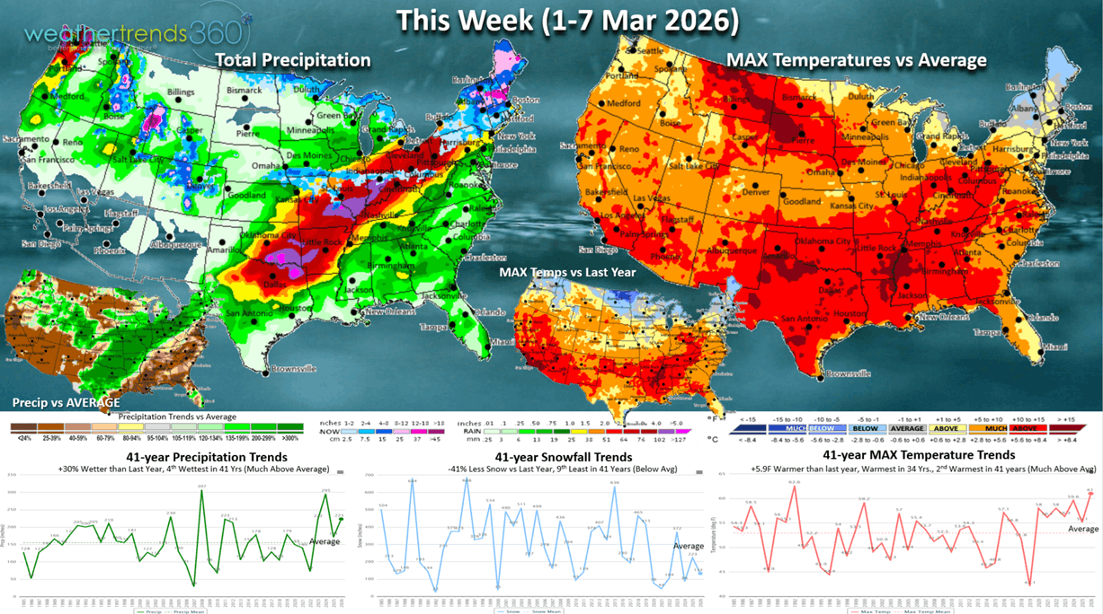
This week (1-7 March) across the U.S. trends +5.9F warmer than last year, warmest in 34 years and 2nd warmest in 41 years. Snowfall down -41% vs LY and 9th least in 41 years, while rainfall is up +30% vs LY and 4th wettest in 41 years. The warmth is good, the rain is not for overall seasonal sales.
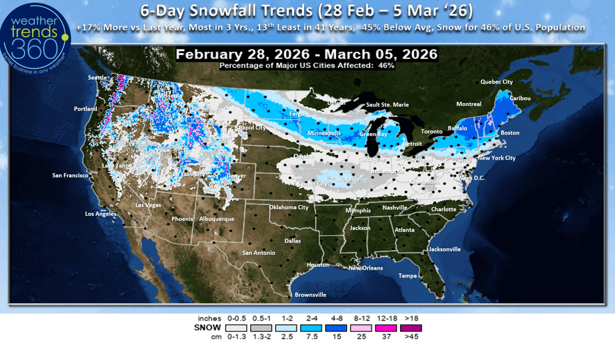
The 6-day snowfall outlook shows a Clipper-like system bringing some light to moderate snow to the Upper Midwest and into the Northeast. The 6-day (28 Feb - 5 Mar) snowfall trends +17% more than LY, most in 3 years with 46% of the U.S. population getting some snow.
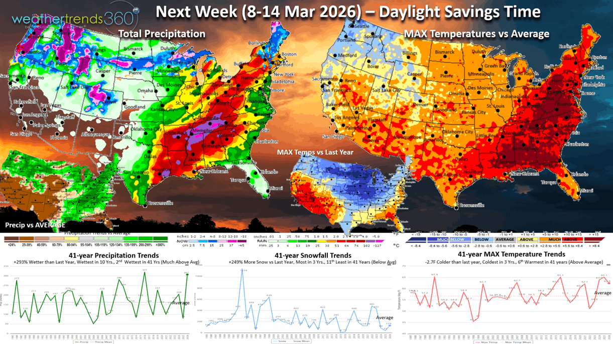
Next week (8-14 March) is the start of Daylight Savings Time and starting to see the potential for a glancing shot of the Polar Vortex at the end of this week. Prior to that, the week overall trends -2.7F colder than last year, coolest in 3 years but 6th warmest of the past 41 years. Snowfall up +249% vs LY, most in 3 years, while rainfall is way up +293% vs LY, most in 10 years and 2nd wettest in 41 years. This is a bigger negative for store traffic and especially lawn and garden categories.

The World 2-week (1-14 March) Temperature outlook shows warmer in the U.S. and Europe, coder Canada and Russia and very hot in the Middle East - Asia.
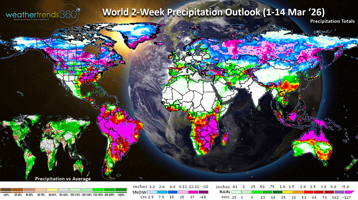
The World 2-week (1-14 March) Precipitation outlook shows the very stormy U.S. pattern and continued wet across South America, but very dry in Europe.
You can get this blog/video in your email inbox every Saturday (FREE) via subscription.
Have a great week ahead, and don't forget to follow us on social media for updates: Facebook, Twitter(X), YouTube, Pinterest and Linkedin.
- Captain Kirk out (USAF Gulf War Veteran 1989-1999)