wt360 Weather Brief 16 May '26 Wettest Latter Half of May in 11 Years
Captain's Log
16 May '26: Happy Saturday! :)
We have added about 5,000 YouTube fans and 2,600 subscribers to this newsletter since we last explained why Captain Kirk says the "Real Captain Kirk". Nearly 35 years ago today (19 May 1991), General "Stormin" Norman Schwarzkopf was knighted by the Queen of England after Desert Storm in Hangar 3 at MacDill Air Force Base. CLICK ON IMAGES FOR A LARGER VIEW.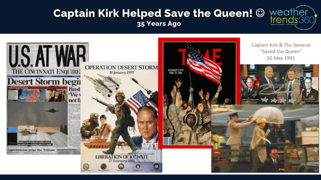
3am that morning, then 1LT Kirk (MacDill Air Force Base Wing Weather Officer) gave the General the precise minute-by-minute forecast of "sea fog lifting out right as the Queen arrives, with the hangar cement floor being very slippery, but then the sun comes out for a beautiful ceremony." That day all I heard was a lot of gasps and hundreds of camera clicks, not knowing what happened until 16 years later when I was invited to be on a TV show hosted by then Civilian Schwarzkopf. When the General walked into the green room before the TV segment, I politely said, "I know you don't remember me General..." interrupted he said, "I do Captain, now let me tell you the rest of the story." On that Knighting ceremony day CENTCOM meteorologists never mentioned the slippery hangar ceremony floor, but that minor mention had the General ready with the now famous umbrella (it wasn't raining, just mist from sea fog). He had been briefed by the Queen's entourage on all the things he couldn't do, touch the Queen, etc. As she got out of the vehicle she slipped and nearly had a severe fall (the reasons for the gasps and camera clicks), but in a swan like dance move, the General grabbed the Queen by the hips, umbrella in hand, pivoted her elegantly onto the hangar floor and that was the day the General saved the Queen! He then said to me, "Captain, that was the day WE saved the Queen because of your forecast." :) Put that on my resume. LOL
A year later he was Knighted again in England when the Queen presented him with a scrap book full of all the photos of the General saving the Queen. When she made that scrapbook on the return flight from MacDill, she asked her entourage for all the photos of the General saving her, they said, "Mum, we got rid of all the inappropriate photos." She replies, "I WANT THOSE PHOTOS." So, end story on how a precise and accurate weather forecast saved the Queen. On a prior 10-minute walk with the General back in the Fall of 1989, comments from the General to the 2LT Kirk led to the inspiration for year-ahead weather forecasting.
We are getting very close to launching what we believe will be the coolest talking weather app you've ever seen, a year in the making! TOP SECRET for now. Today we ask the w360 robot for an update on the rapidly developing El Nino.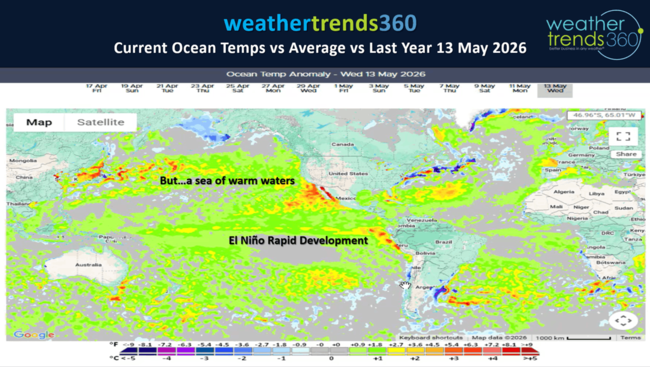
Near certainty this will be at least a top 5 strongest El Nino in 76 years of NOAA era records, possibly #1 eclipsing the record event 149 years ago (1877-1878). The one caveat is the North Pacific Ocean Temps are also very warm so we don't have the typical contrast between cold/warm waters with a traditional El Nino. That said, we still expect a cool increasingly wet Summer, becoming very wet late through Fall into Winter with floods replacing droughts of the past 5 years.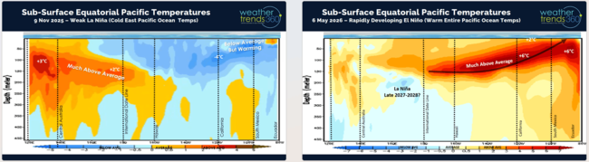
The sub-surface Equatorial Ocean temperatures are still +6C above average and percolating to the surface. +2C at the surface is considered a super El Nino, very likely we get there.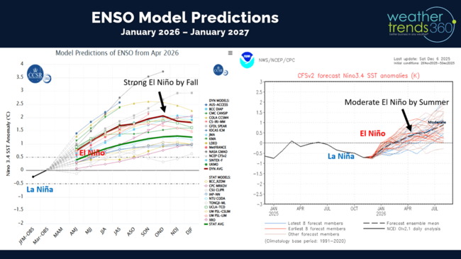
Models show a very strong event and at least the strongest in 10 years (2015-2016 #2 strongest El Nino of the past 147 years).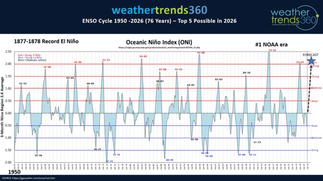
We added another hit (#10) to our year-ahead Spring 2026 Severe Weather Outlook with the snowstorm in Colorado and now more snow in the Rockies here in May. These reports go out a rolling year-ahead by quarter.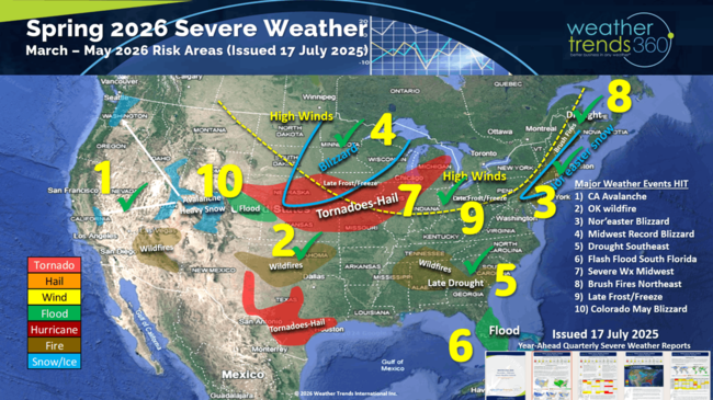
Severe weather was a bit calmer last week with only +17 tornadoes, +191 hail events and 493 wind events from the prior week. Ironically one of those hail events was at the home of wt360 Meteorologist Krissy, actually accumulated on the ground.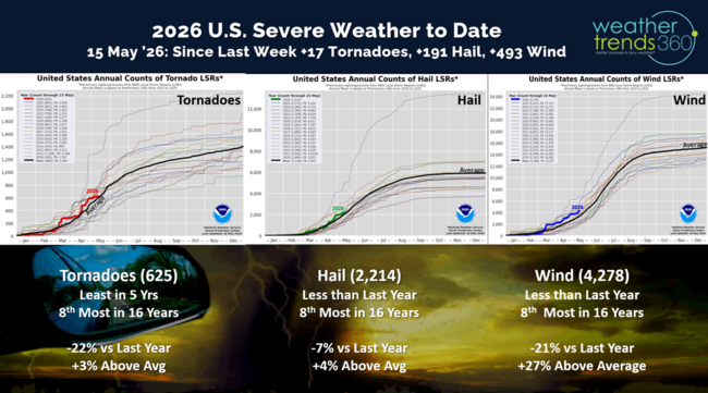
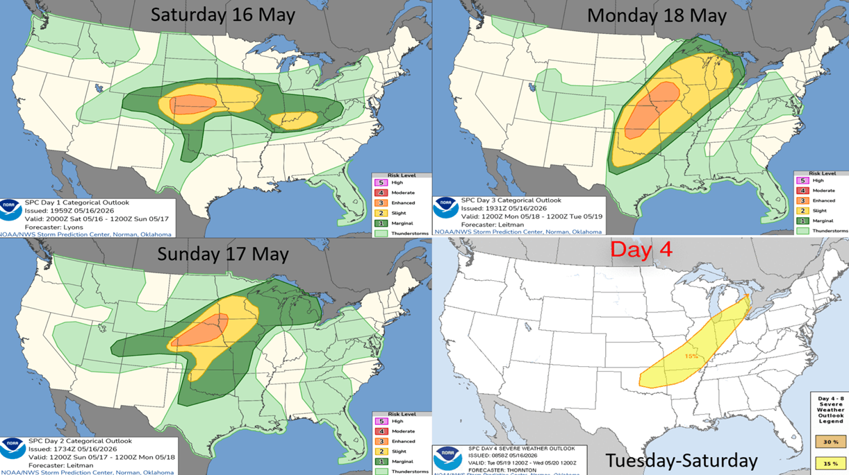
But, the week ahead outlook shows a return to a very active pattern in the Heartland with day-after-day of severe weather.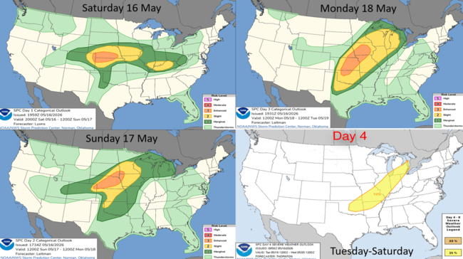
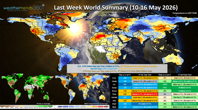
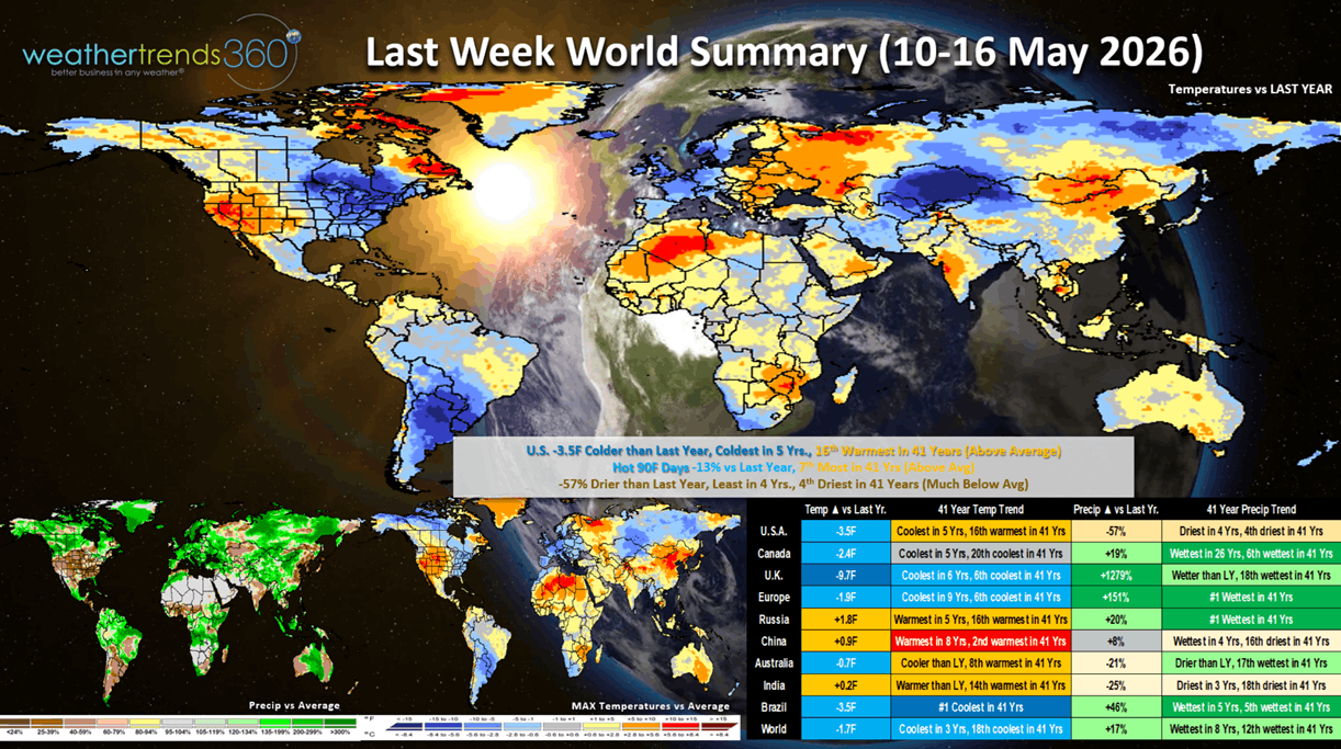
Last week (10-16 May) across the World shows the U.S. trending colder YOY for the 4th straight week trending -3.5F cooler than last year, coolest in 5 years, but 16th warmest of the past 41 years. Hot 90F days were down -13% vs LY, while rainfall was down -57% vs LY, least in 4 years and 4th least in 41 years. Canada had its 12th straight week of colder YOY conditions for a delayed Spring. The U.K. and Europe also turned much cooler and much wetter - #1 wettest in 41 years for Europe overall. These are negative trends for retail Spring merchandise sales. Continued very cool and wet across Brazil benefiting their second season crops.
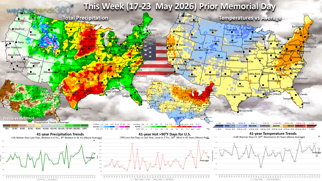
This week (17-23 May) prior to the very early Memorial Day weekend shows a big midweek short lived heat-wave in the East but turning much cooler for the holiday weekend in the East. The U.S. overall trends +3.8F warmer than last year and 10th warmest of the past 41 years, but hot 90F days are actually down nationally -19%, least in 3 years, while rainfall is up +1% vs last year and wettest in 6 years. Hot Summer categories will get a brief uptick in sales.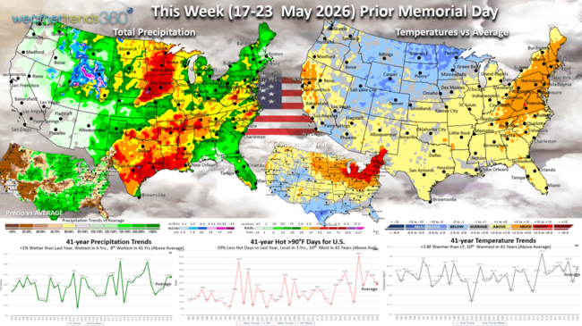
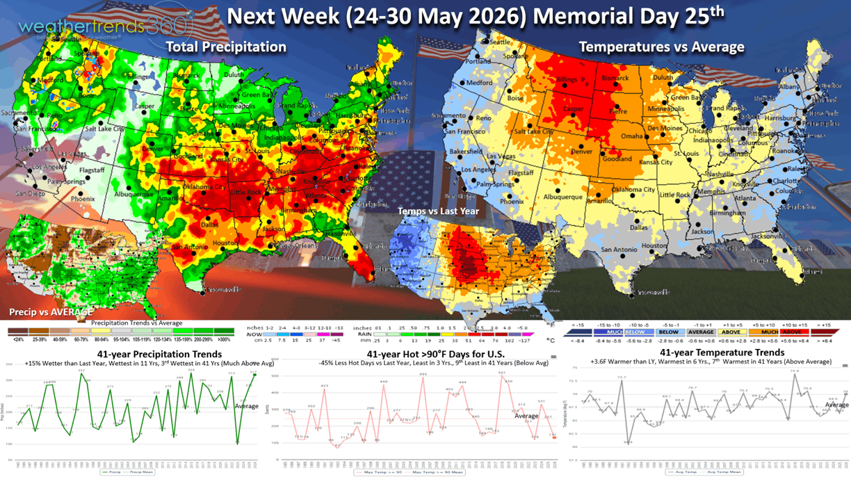
Next week (24-30 May) shows the U.S. trending +3.6F warmer than last year, warmest in 6 years, but below average temperatures along the East and West Coasts. Hot 90F day way down -45%, least in 3 years and rainfall up +15%, wettest in 11 years and 3rd wettest in the past 41 years. These are generally unfavorable conditions for Spring merchandise sales.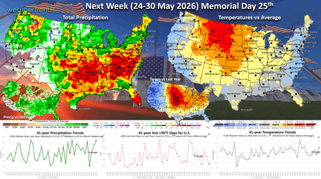
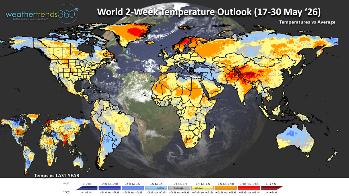
The World 2-week Temperature Outlook (17-30 May) shows a milder but much stormier pattern across the U.S. and Europe.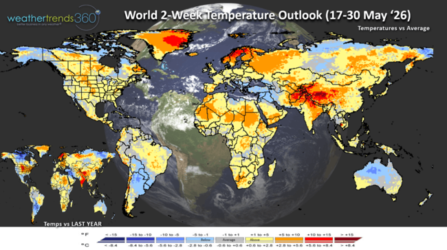
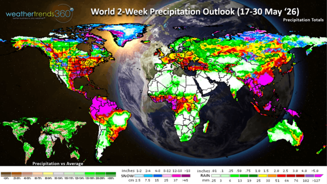
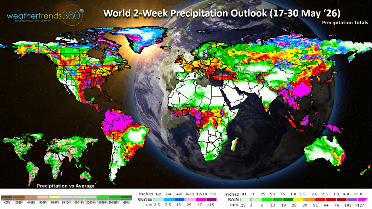
The World 2-week Precipitation Outlook (17-30 May) shows a wet U.S., Southern Brazil, Central Europe and the Middle East.
You can get this blog/video in your email inbox every Saturday (FREE) via subscription.
Have a great week ahead, and don't forget to follow us on social media for updates: Facebook, Twitter(X), YouTube, Pinterest and Linkedin.
- Captain Kirk out (USAF Gulf War Veteran 1989-1999)
We have added about 5,000 YouTube fans and 2,600 subscribers to this newsletter since we last explained why Captain Kirk says the "Real Captain Kirk". Nearly 35 years ago today (19 May 1991), General "Stormin" Norman Schwarzkopf was knighted by the Queen of England after Desert Storm in Hangar 3 at MacDill Air Force Base. CLICK ON IMAGES FOR A LARGER VIEW.
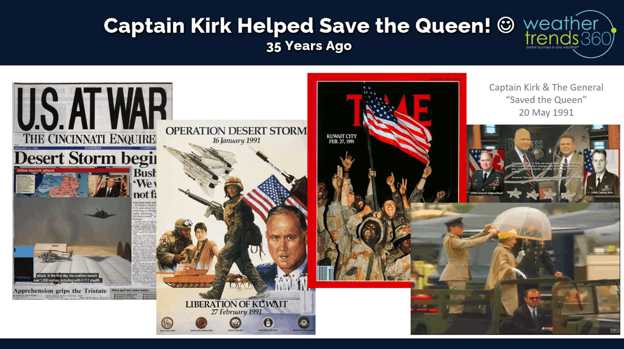
3am that morning, then 1LT Kirk (MacDill Air Force Base Wing Weather Officer) gave the General the precise minute-by-minute forecast of "sea fog lifting out right as the Queen arrives, with the hangar cement floor being very slippery, but then the sun comes out for a beautiful ceremony." That day all I heard was a lot of gasps and hundreds of camera clicks, not knowing what happened until 16 years later when I was invited to be on a TV show hosted by then Civilian Schwarzkopf. When the General walked into the green room before the TV segment, I politely said, "I know you don't remember me General..." interrupted he said, "I do Captain, now let me tell you the rest of the story." On that Knighting ceremony day CENTCOM meteorologists never mentioned the slippery hangar ceremony floor, but that minor mention had the General ready with the now famous umbrella (it wasn't raining, just mist from sea fog). He had been briefed by the Queen's entourage on all the things he couldn't do, touch the Queen, etc. As she got out of the vehicle she slipped and nearly had a severe fall (the reasons for the gasps and camera clicks), but in a swan like dance move, the General grabbed the Queen by the hips, umbrella in hand, pivoted her elegantly onto the hangar floor and that was the day the General saved the Queen! He then said to me, "Captain, that was the day WE saved the Queen because of your forecast." :) Put that on my resume. LOL
A year later he was Knighted again in England when the Queen presented him with a scrap book full of all the photos of the General saving the Queen. When she made that scrapbook on the return flight from MacDill, she asked her entourage for all the photos of the General saving her, they said, "Mum, we got rid of all the inappropriate photos." She replies, "I WANT THOSE PHOTOS." So, end story on how a precise and accurate weather forecast saved the Queen. On a prior 10-minute walk with the General back in the Fall of 1989, comments from the General to the 2LT Kirk led to the inspiration for year-ahead weather forecasting.

We are getting very close to launching what we believe will be the coolest talking weather app you've ever seen, a year in the making! TOP SECRET for now. Today we ask the w360 robot for an update on the rapidly developing El Nino.
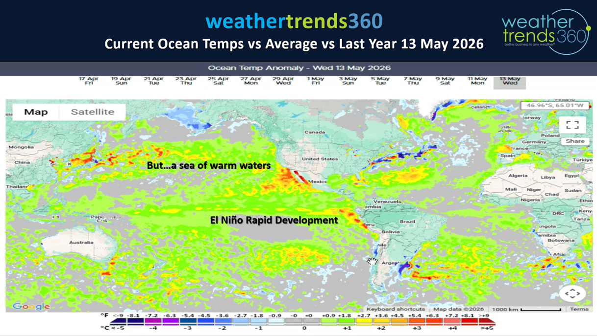
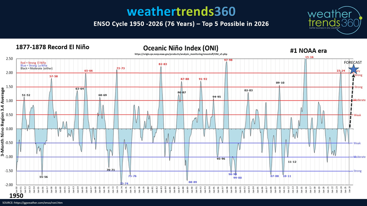
Near certainty this will be at least a top 5 strongest El Nino in 76 years of NOAA era records, possibly #1 eclipsing the record event 149 years ago (1877-1878). The one caveat is the North Pacific Ocean Temps are also very warm so we don't have the typical contrast between cold/warm waters with a traditional El Nino. That said, we still expect a cool increasingly wet Summer, becoming very wet late through Fall into Winter with floods replacing droughts of the past 5 years.
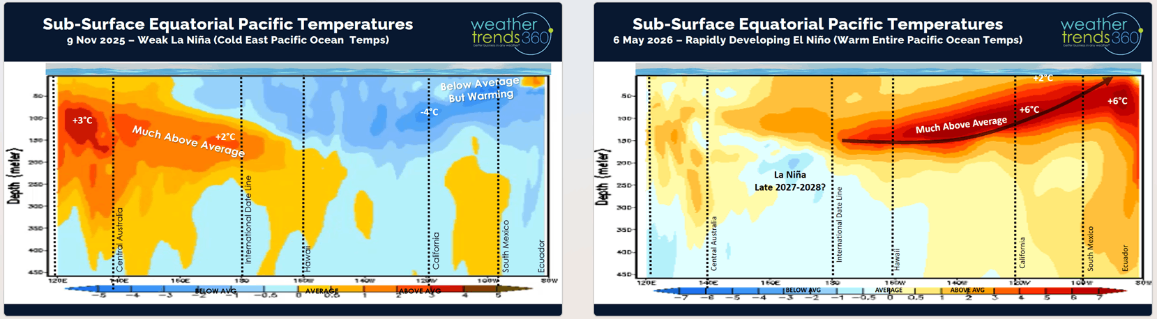
The sub-surface Equatorial Ocean temperatures are still +6C above average and percolating to the surface. +2C at the surface is considered a super El Nino, very likely we get there.
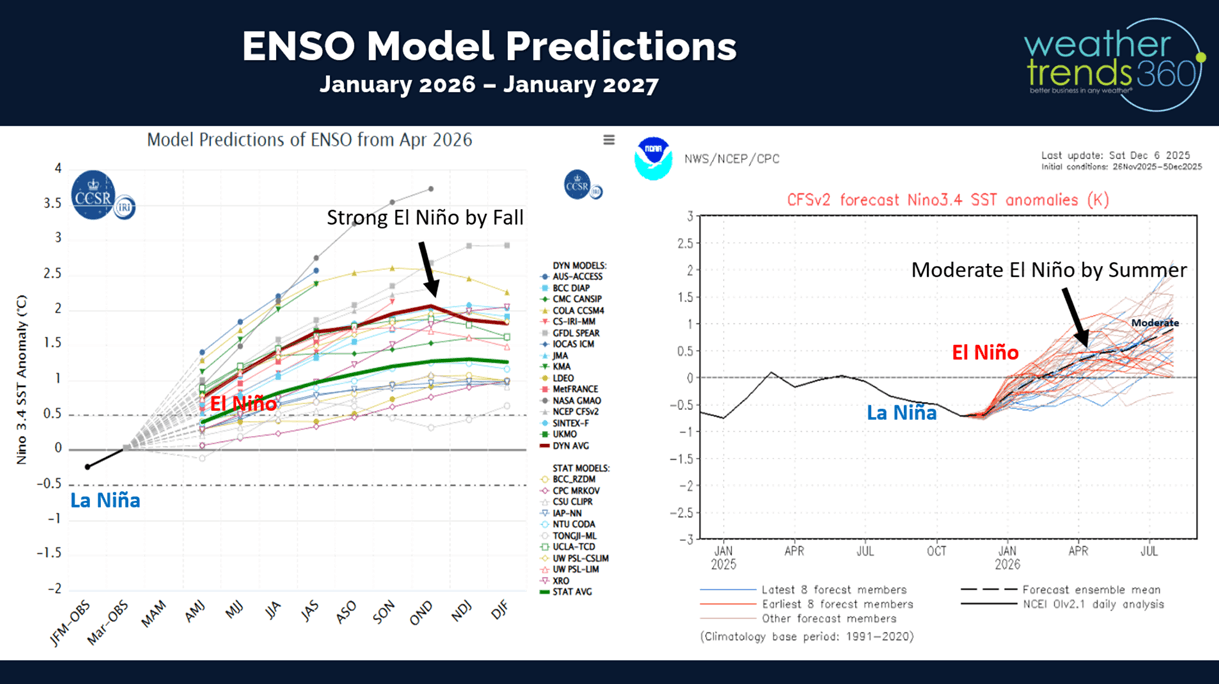
Models show a very strong event and at least the strongest in 10 years (2015-2016 #2 strongest El Nino of the past 147 years).
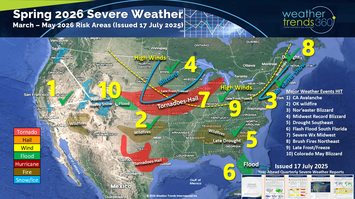
We added another hit (#10) to our year-ahead Spring 2026 Severe Weather Outlook with the snowstorm in Colorado and now more snow in the Rockies here in May. These reports go out a rolling year-ahead by quarter.
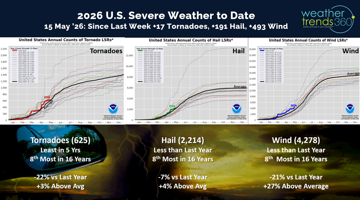
Severe weather was a bit calmer last week with only +17 tornadoes, +191 hail events and 493 wind events from the prior week. Ironically one of those hail events was at the home of wt360 Meteorologist Krissy, actually accumulated on the ground.
But, the week ahead outlook shows a return to a very active pattern in the Heartland with day-after-day of severe weather.
Last week (10-16 May) across the World shows the U.S. trending colder YOY for the 4th straight week trending -3.5F cooler than last year, coolest in 5 years, but 16th warmest of the past 41 years. Hot 90F days were down -13% vs LY, while rainfall was down -57% vs LY, least in 4 years and 4th least in 41 years. Canada had its 12th straight week of colder YOY conditions for a delayed Spring. The U.K. and Europe also turned much cooler and much wetter - #1 wettest in 41 years for Europe overall. These are negative trends for retail Spring merchandise sales. Continued very cool and wet across Brazil benefiting their second season crops.
This week (17-23 May) prior to the very early Memorial Day weekend shows a big midweek short lived heat-wave in the East but turning much cooler for the holiday weekend in the East. The U.S. overall trends +3.8F warmer than last year and 10th warmest of the past 41 years, but hot 90F days are actually down nationally -19%, least in 3 years, while rainfall is up +1% vs last year and wettest in 6 years. Hot Summer categories will get a brief uptick in sales.
Next week (24-30 May) shows the U.S. trending +3.6F warmer than last year, warmest in 6 years, but below average temperatures along the East and West Coasts. Hot 90F day way down -45%, least in 3 years and rainfall up +15%, wettest in 11 years and 3rd wettest in the past 41 years. These are generally unfavorable conditions for Spring merchandise sales.
The World 2-week Temperature Outlook (17-30 May) shows a milder but much stormier pattern across the U.S. and Europe.
The World 2-week Precipitation Outlook (17-30 May) shows a wet U.S., Southern Brazil, Central Europe and the Middle East.
You can get this blog/video in your email inbox every Saturday (FREE) via subscription.
Have a great week ahead, and don't forget to follow us on social media for updates: Facebook, Twitter(X), YouTube, Pinterest and Linkedin.
- Captain Kirk out (USAF Gulf War Veteran 1989-1999)