wt360 Weather Brief 11 Jul '26: Hot/Dry West...Typical/Wetter East
Captain's Log
11 July 2026: Happy Saturday! :)
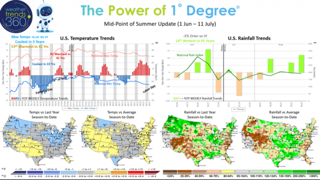
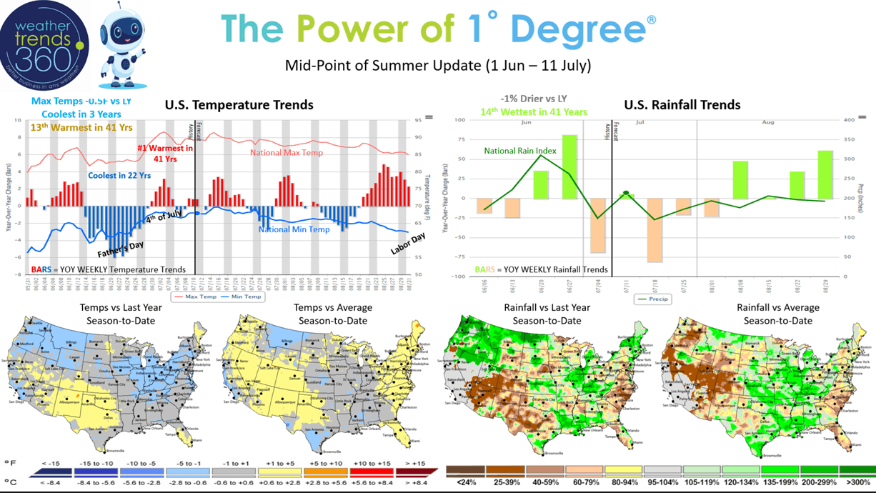
We're almost at the half way point of Meteorological Summer (Jun - Aug) and it's been a roller coaster of weather trends. Late June goes from the coldest in 22 years nationally followed by a scorching early July heatwave. Now that heat is shifting to the North Central U.S., the Eastern U.S. has turned generally more seasonable and wetter and overall cooler than last year. CLICK ON IMAGES FOR A LARGER VIEW.
August should start to turn much wetter as we transition into the near historic El Niño event.
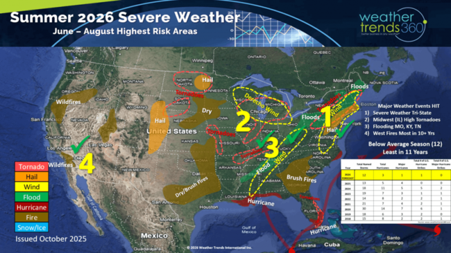
The wt360 year-ahead Summer severe weather outlook is hinting on some of the bigger events including all the severe wind events that are now the most in 15 years. Captured some of the flooding events in the Tennessee Valley and the fires out west that are the most in 10+ years. Colorado State University just lowered their expectations for the 2026 hurricane season to now by much below average with just 9 named storms. The wt360 long range outlook issued back in October suggested 12 named storms and the least in 11 years.
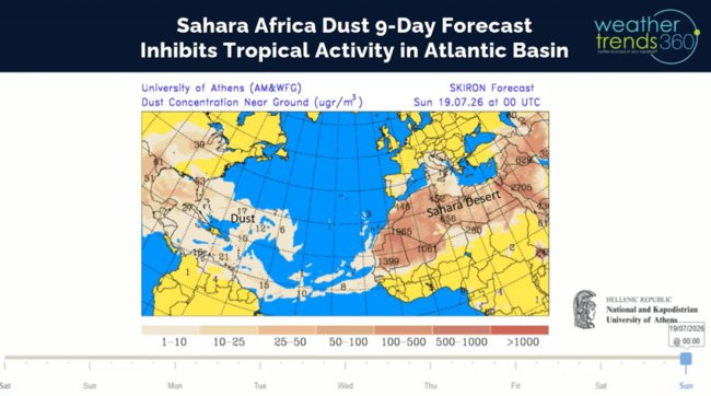
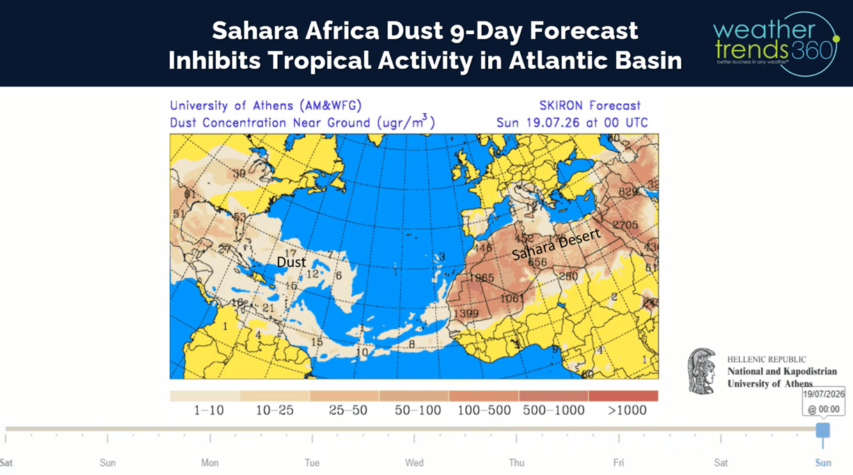
The reason for the downgrade is due to excessive wind shear in the Atlantic Basin (common with El Nino events) and a lot of Sahara Dust coming off Africa that inhibits development. The 9-day forecast above shows that dust making it all the way to the Gulf of Mexico and even inland U.S. The late c0re season likely to become active with the highest threat area Southeast Florida.
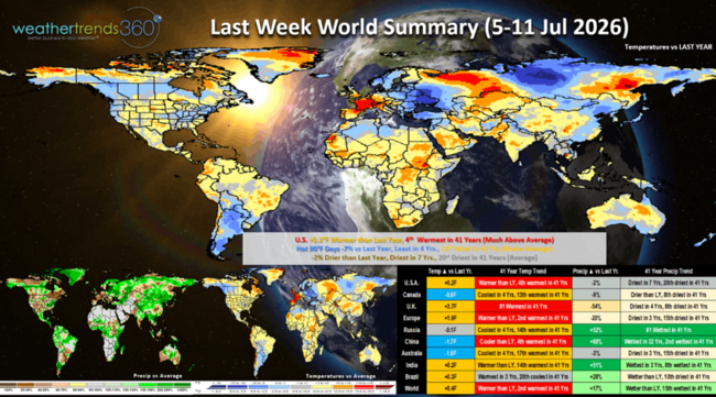
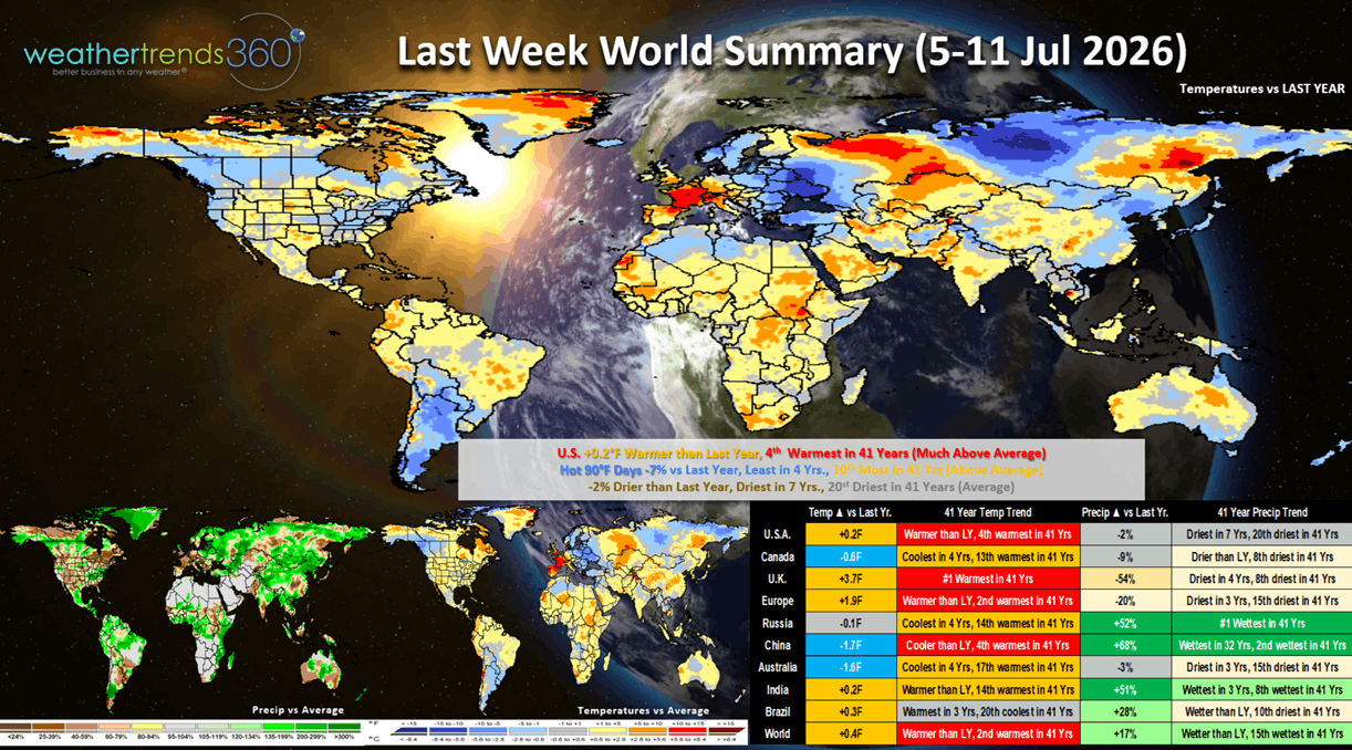
Last week (5-11 July) across the World shows the U.S. trending +0.2F warmer than last year and 4th warmest of the past 41 years. The excessive heat in the Northeast ended with building heat in the Upper Plains. It was the #1 hottest in 41 years across the U.K. and 2nd warmest for Europe. This is exceptional weather for consumable Summer categories like cold beverages, fans, suncare, fruits and vegetables. It was excessively wet across Russia and China (especially the Northeast where they grow their Summer crops) trending in the top 2 wettest in 41 years.
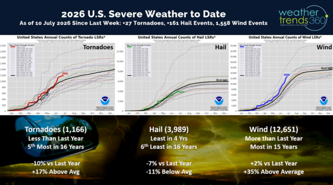
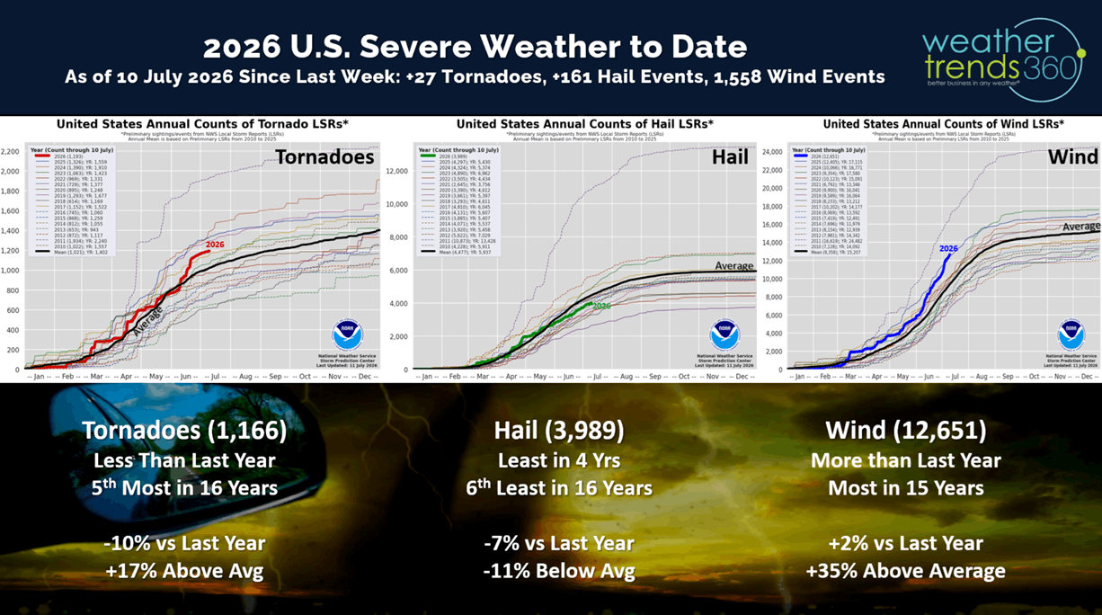
Severe weather last week shows we added 27 tornadoes, 161 hail events and a very significant 1,558 wind events. This now has wind cases up +2% over last year and the most in 15 years. Severe weather will get another big surge this Fall across the Southeast with the peaking El Niño.
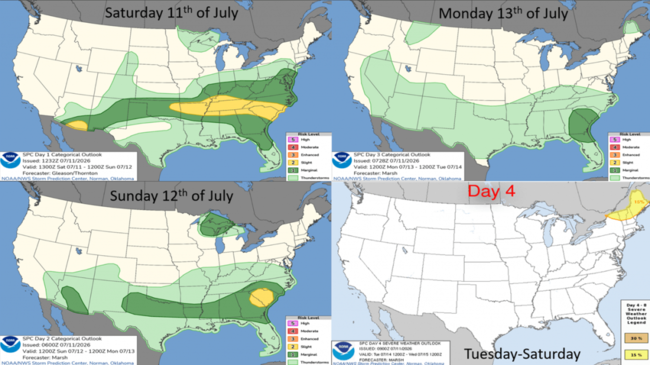
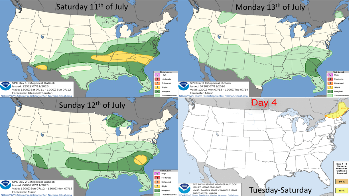
The week ahead severe weather outlook shows some risk in the Southeast - Middle Atlantic this weekend and then some risk New England and the Middle Atlantic in the week ahead.
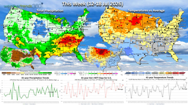
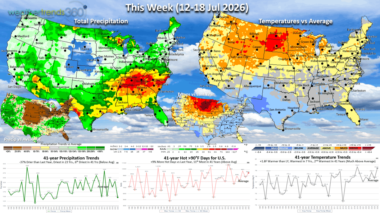
This week (12-18 Jul) shows the current heat dome over the Upper Plains with a brief heat-wave the middle of next week in the Northeast. This will be a much less intense heat-wave with below average temperatures returning to the Northeast by the weekend (17-19th). The heaviest rain will continue to be from Arkansas to South Carolina where some areas have been hit hard with flooding. Very dry across the U.S. Corn Belt (NE - IN) will bring some crop stress, but they had ample soil moisture prior to this dry spell. The U.S. overall trends +1.8F warmer than last year, warmest in 7 years and 2nd warmest in 41 years. Hot 90F days again tick up +9% over LY and 11th most in 41 years, while rainfall is down -37% vs LY, least in 23 years and 6th least in 41 years. These are generally favorable trends for consumable food and beverage categories, suncare, pool supplies and outdoor categories.
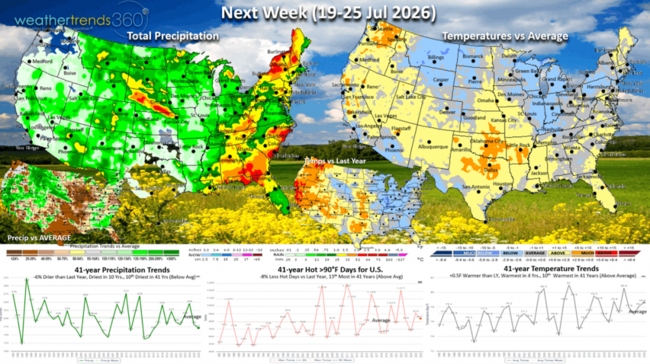
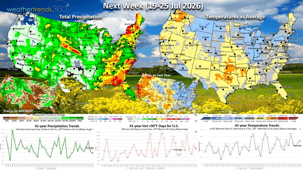
Next week (19-25 Jul) shows a cooling trend for the northern tier of the U.S. from Montana to Pennsylvania with much cooler conditions for the North Central U.S. The heat will shit to the Pacific Northwest and South Central U.S. Rainfall will be heaviest in the Southeast and Northeast. Some thunderstorm activity in the Western mountains poses the risk for lightning induced wildfires. The U.S. overall trends +0.5F warmer than last year, warmest in 4 years and 10th warmest of the past 41 years. But, hot 90F days actually trend down -8% vs LY and 13th most in 41 years nationally. Rainfall again down -6% vs LY, driest in 10 years and 10th driest in 41 years. The greatest demand for hot Summer categories will shift to the NW and South Central states.
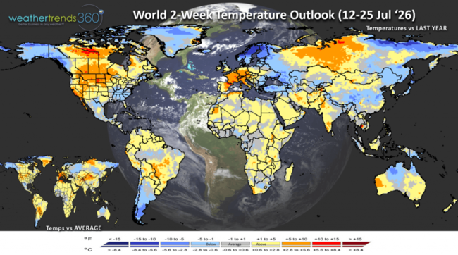
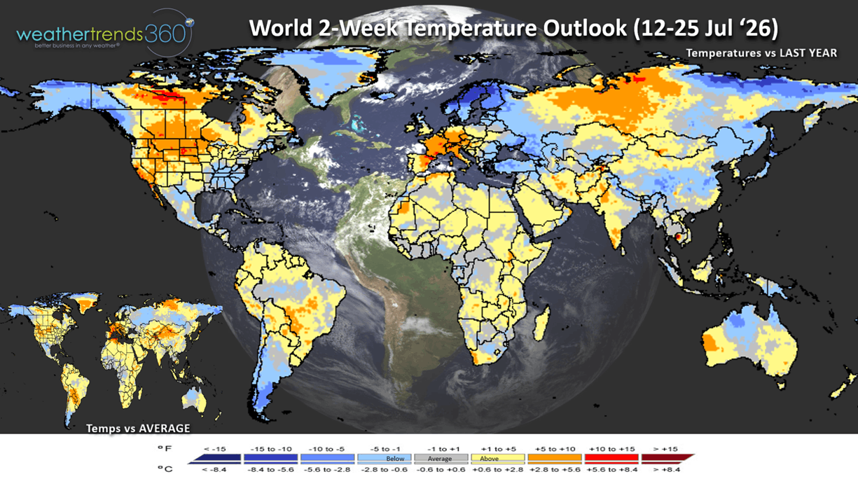
The World 2-week Temperature Outlook (12-25 July) shows three heat domes across the World in the Central U.S./Central Canada, Central Europe and Central Russia.
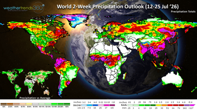
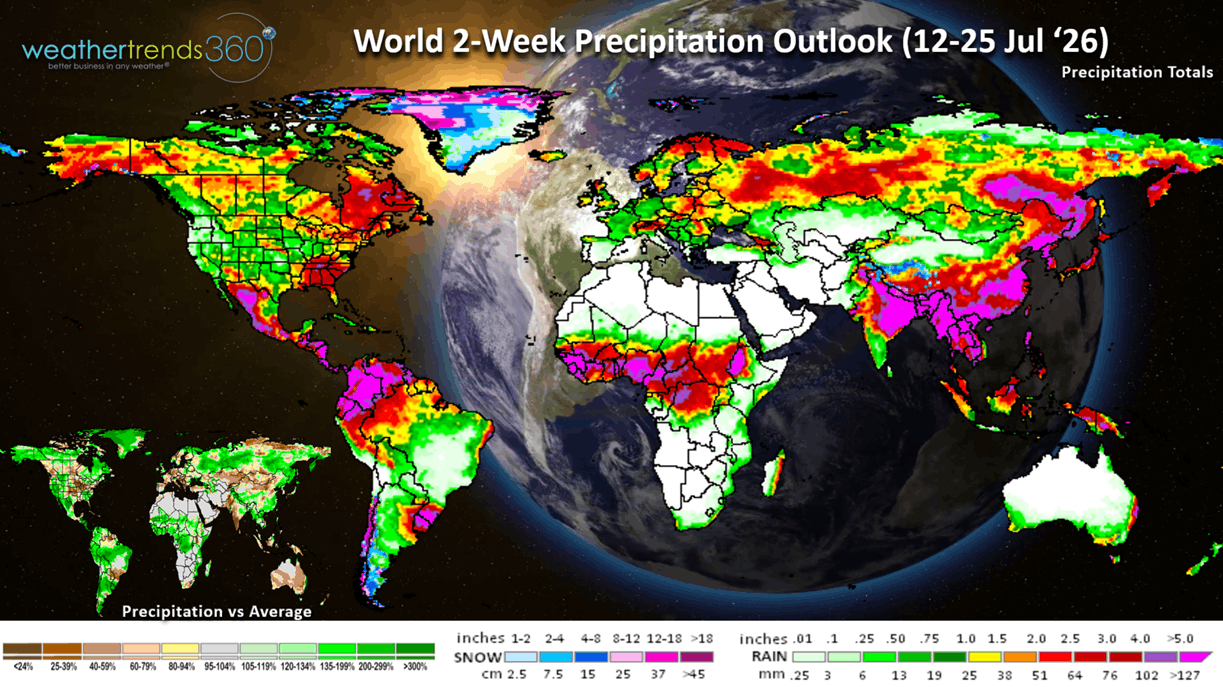
The World 2-week Precipitation Outlook (12-25 July) shows generally dry conditions in the Central U.S. and most of Europe and Australia. Several Typhoons likely to impact Eastern China with flooding rain.
You can get this blog in your email inbox every weekend (FREE) via subscription.
Have a great week ahead, and don't forget to follow us on social media for updates: Facebook, Twitter(X), YouTube, Pinterest and Linkedin.
- Captain Kirk out (USAF Gulf War Veteran 1989-1999)
We're almost at the half way point of Meteorological Summer (Jun - Aug) and it's been a roller coaster of weather trends. Late June goes from the coldest in 22 years nationally followed by a scorching early July heatwave. Now that heat is shifting to the North Central U.S., the Eastern U.S. has turned generally more seasonable and wetter and overall cooler than last year. CLICK ON IMAGES FOR A LARGER VIEW.
August should start to turn much wetter as we transition into the near historic El Niño event.
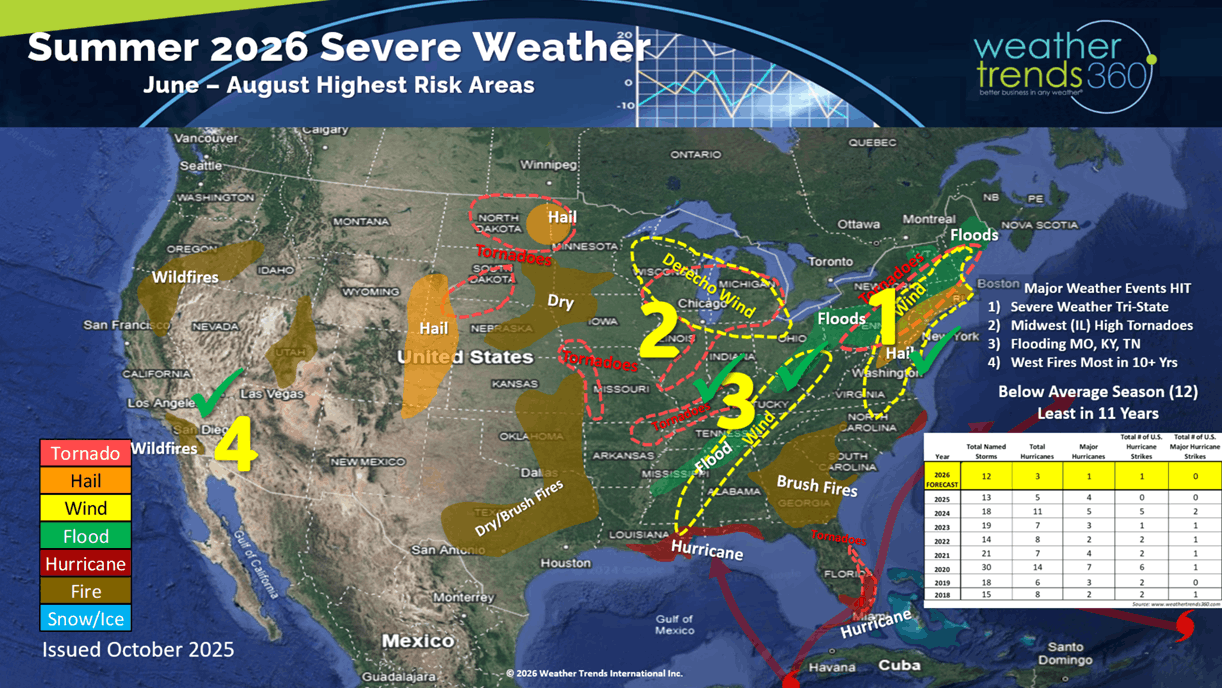
The wt360 year-ahead Summer severe weather outlook is hinting on some of the bigger events including all the severe wind events that are now the most in 15 years. Captured some of the flooding events in the Tennessee Valley and the fires out west that are the most in 10+ years. Colorado State University just lowered their expectations for the 2026 hurricane season to now by much below average with just 9 named storms. The wt360 long range outlook issued back in October suggested 12 named storms and the least in 11 years.
The reason for the downgrade is due to excessive wind shear in the Atlantic Basin (common with El Nino events) and a lot of Sahara Dust coming off Africa that inhibits development. The 9-day forecast above shows that dust making it all the way to the Gulf of Mexico and even inland U.S. The late c0re season likely to become active with the highest threat area Southeast Florida.
Last week (5-11 July) across the World shows the U.S. trending +0.2F warmer than last year and 4th warmest of the past 41 years. The excessive heat in the Northeast ended with building heat in the Upper Plains. It was the #1 hottest in 41 years across the U.K. and 2nd warmest for Europe. This is exceptional weather for consumable Summer categories like cold beverages, fans, suncare, fruits and vegetables. It was excessively wet across Russia and China (especially the Northeast where they grow their Summer crops) trending in the top 2 wettest in 41 years.
Severe weather last week shows we added 27 tornadoes, 161 hail events and a very significant 1,558 wind events. This now has wind cases up +2% over last year and the most in 15 years. Severe weather will get another big surge this Fall across the Southeast with the peaking El Niño.
The week ahead severe weather outlook shows some risk in the Southeast - Middle Atlantic this weekend and then some risk New England and the Middle Atlantic in the week ahead.
This week (12-18 Jul) shows the current heat dome over the Upper Plains with a brief heat-wave the middle of next week in the Northeast. This will be a much less intense heat-wave with below average temperatures returning to the Northeast by the weekend (17-19th). The heaviest rain will continue to be from Arkansas to South Carolina where some areas have been hit hard with flooding. Very dry across the U.S. Corn Belt (NE - IN) will bring some crop stress, but they had ample soil moisture prior to this dry spell. The U.S. overall trends +1.8F warmer than last year, warmest in 7 years and 2nd warmest in 41 years. Hot 90F days again tick up +9% over LY and 11th most in 41 years, while rainfall is down -37% vs LY, least in 23 years and 6th least in 41 years. These are generally favorable trends for consumable food and beverage categories, suncare, pool supplies and outdoor categories.
Next week (19-25 Jul) shows a cooling trend for the northern tier of the U.S. from Montana to Pennsylvania with much cooler conditions for the North Central U.S. The heat will shit to the Pacific Northwest and South Central U.S. Rainfall will be heaviest in the Southeast and Northeast. Some thunderstorm activity in the Western mountains poses the risk for lightning induced wildfires. The U.S. overall trends +0.5F warmer than last year, warmest in 4 years and 10th warmest of the past 41 years. But, hot 90F days actually trend down -8% vs LY and 13th most in 41 years nationally. Rainfall again down -6% vs LY, driest in 10 years and 10th driest in 41 years. The greatest demand for hot Summer categories will shift to the NW and South Central states.
The World 2-week Temperature Outlook (12-25 July) shows three heat domes across the World in the Central U.S./Central Canada, Central Europe and Central Russia.
The World 2-week Precipitation Outlook (12-25 July) shows generally dry conditions in the Central U.S. and most of Europe and Australia. Several Typhoons likely to impact Eastern China with flooding rain.
You can get this blog in your email inbox every weekend (FREE) via subscription.
Have a great week ahead, and don't forget to follow us on social media for updates: Facebook, Twitter(X), YouTube, Pinterest and Linkedin.
- Captain Kirk out (USAF Gulf War Veteran 1989-1999)