wt360 Weather Brief 11 Apr '26: Warm but Wettest in 6 Years Nationally
Captain's Log
11 April '26: Happy Saturday! :)
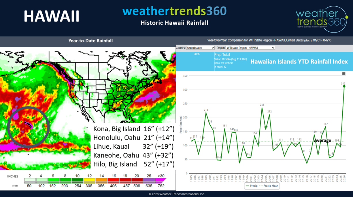
Hawaii doesn't get much attention weather wise until they're hit with Kona low after Kona low bringing historic rainfall to the Islands, with year-to-date rainfall off the scale, the most in over 41 years. CLICK ON IMAGES FOR A LARGER VIEW.
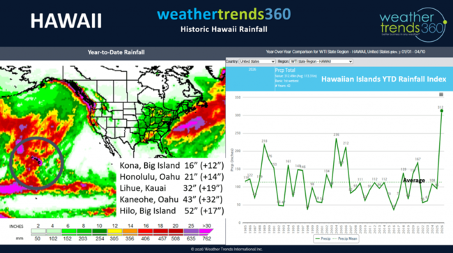
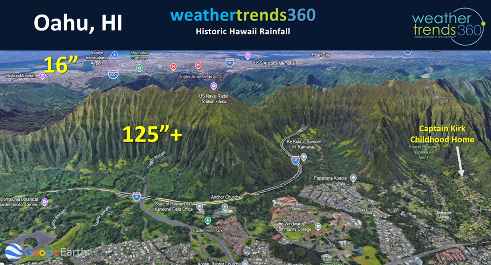
A little Captain Kirk grew up in Kaneohe Hawaii at the base of the Ko'olau Mountains that went straight up nearly 3,000 feet where we averaged 125" of rain a year (most fell at night). But just 5 miles away at the Marine Corps Base they'd only get 16" and on the other side of the Island (Honolulu) they'd get about the same (16"/year). It's one of the most pronounced "rain shadow" effects in the World.

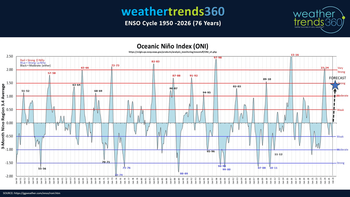
As we gear up for what appears to be a strong to potentially very strong El Niño later this year, the floods will turn to droughts in Hawaii going into next Winter, while the Continental U.S. gets VERY WET ending our years of dry to drought conditions. The Equatorial Pacific Ocean temperatures just below the surface are +6°C above average, we only need +1.5°C at the surface to get a strong El Nino, so odds are increasing for a major climate cycle shift.

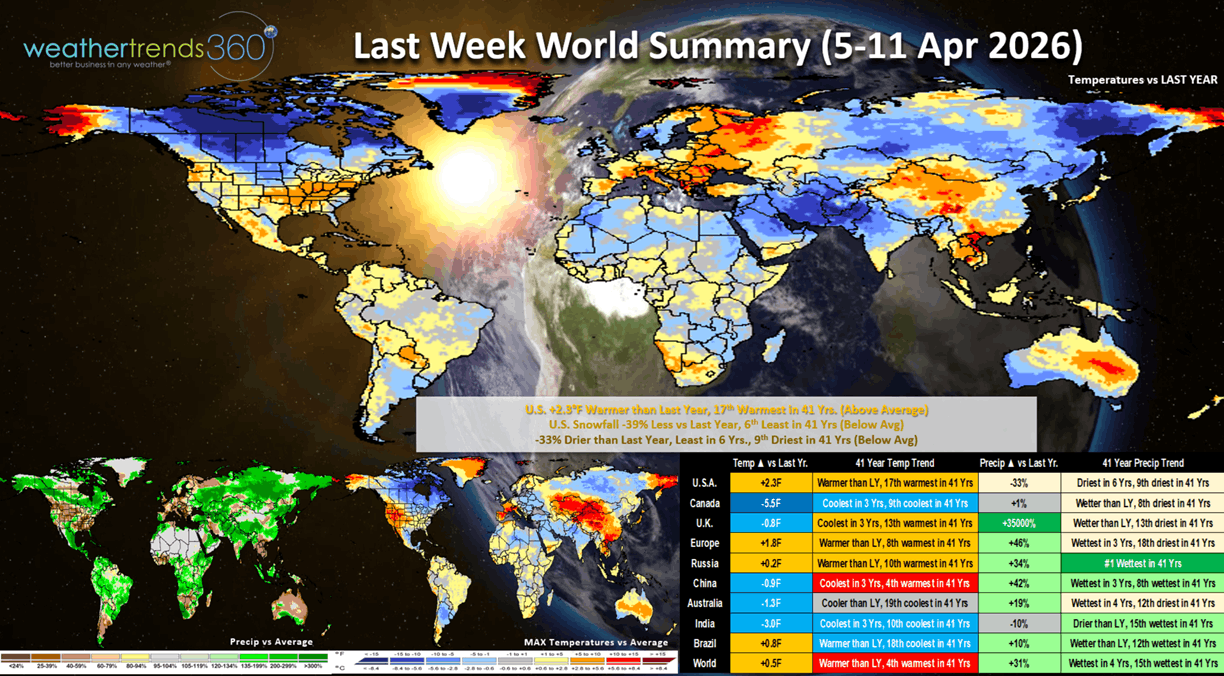
Last week (5-11 April) across the World shows the U.S. trending +2.3F warmer than last year, 17th warmest of the past 41 years. This was a moderating trend from the extreme heat in late March. Snowfall was down -39% vs last year and 6th least in 41 years, while rainfall was down -33%, least in 6 years and 9th driest of the past 41 years. These are favorable trends for Spring merchandise sales after the not so favorable Easter weekend in the East. Continued cold in Canada, warmer across Europe, extremely wet and snowy across Russia and ample rain continuing for Brazil's 2nd crops.

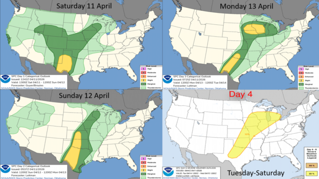
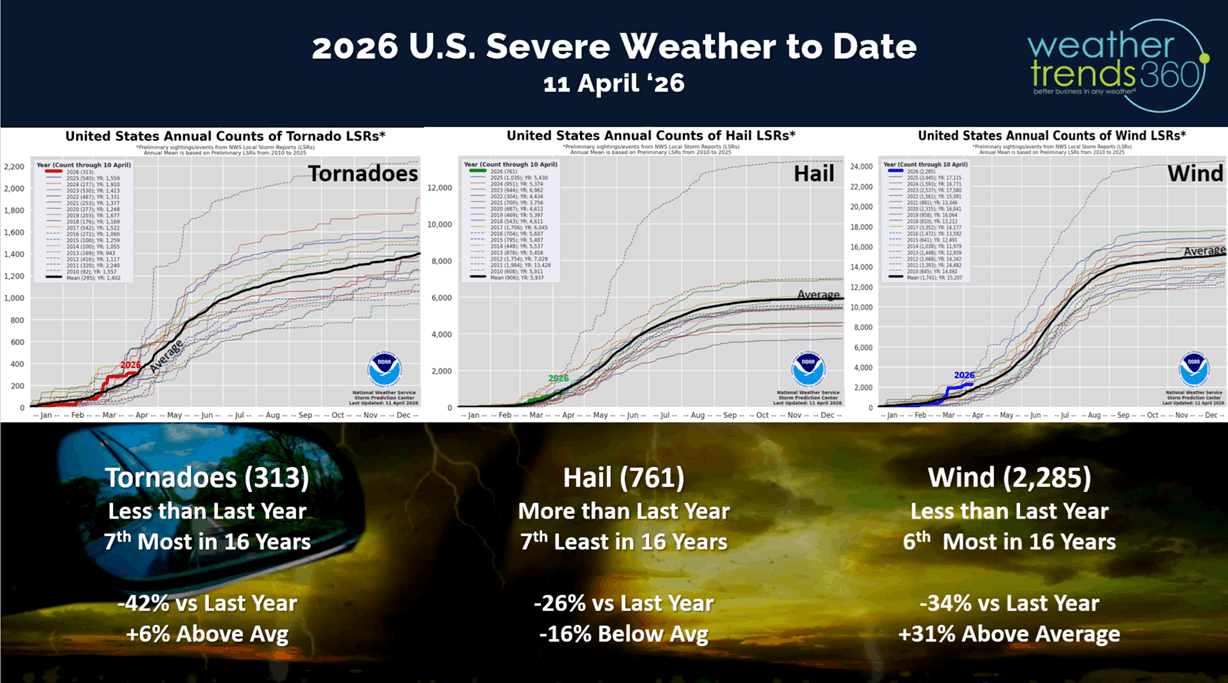
Severe weather across the U.S. is down significantly vs last year's fast start with tornadoes down -42% vs LY, hail cases down -26% and wind cases down -34%.

This could change this week with a prolonged week long threat of severe weather in the Central U.S.
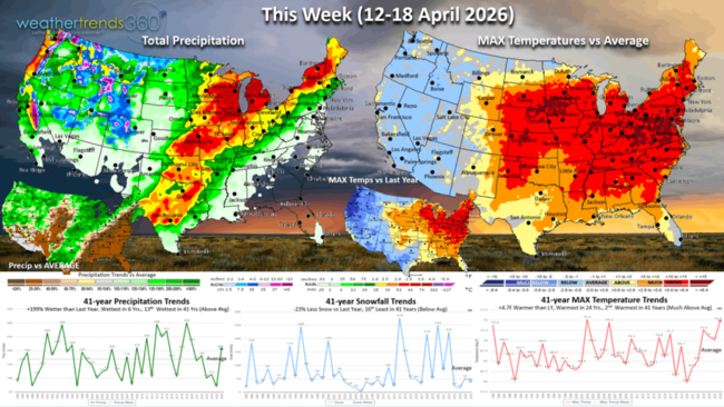
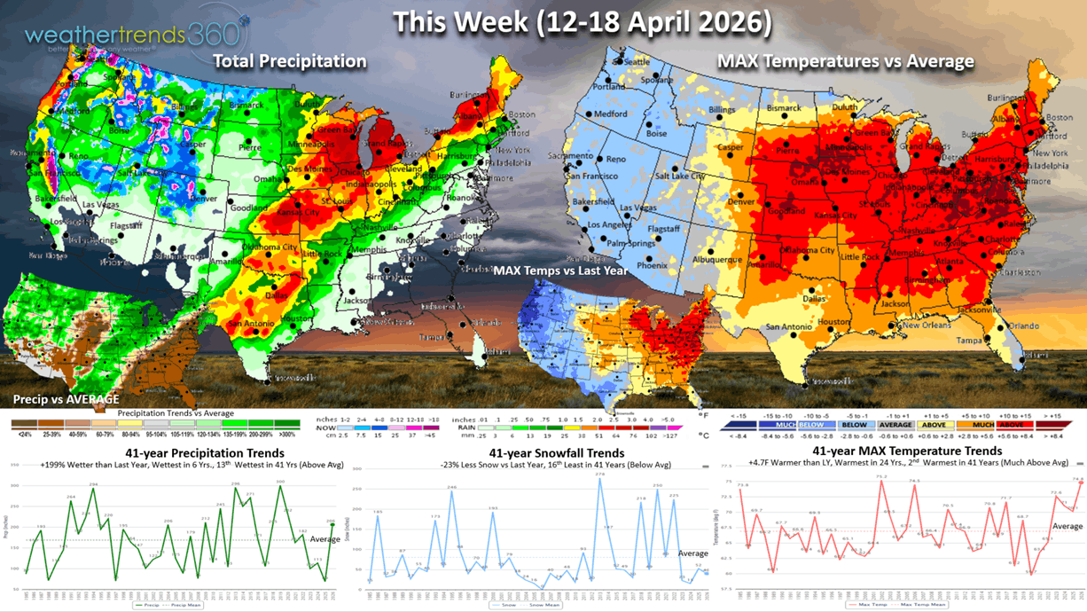
This week (12-18 April) shows Winter making a comeback in the West with a few days of Summer-like weather in the East midweek. The U.S. overall trends +4.7F warmer than last year, warmest in 24 years and 2nd warmest in 41 years. Snowfall down -23% vs last year, while rainfall is up +199% vs LY, most in 6 years and 13th wettest in 41 years. The drought continues in the Southeast while the conveyor belt of moisture plagues Texas to the Great Lakes.
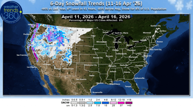
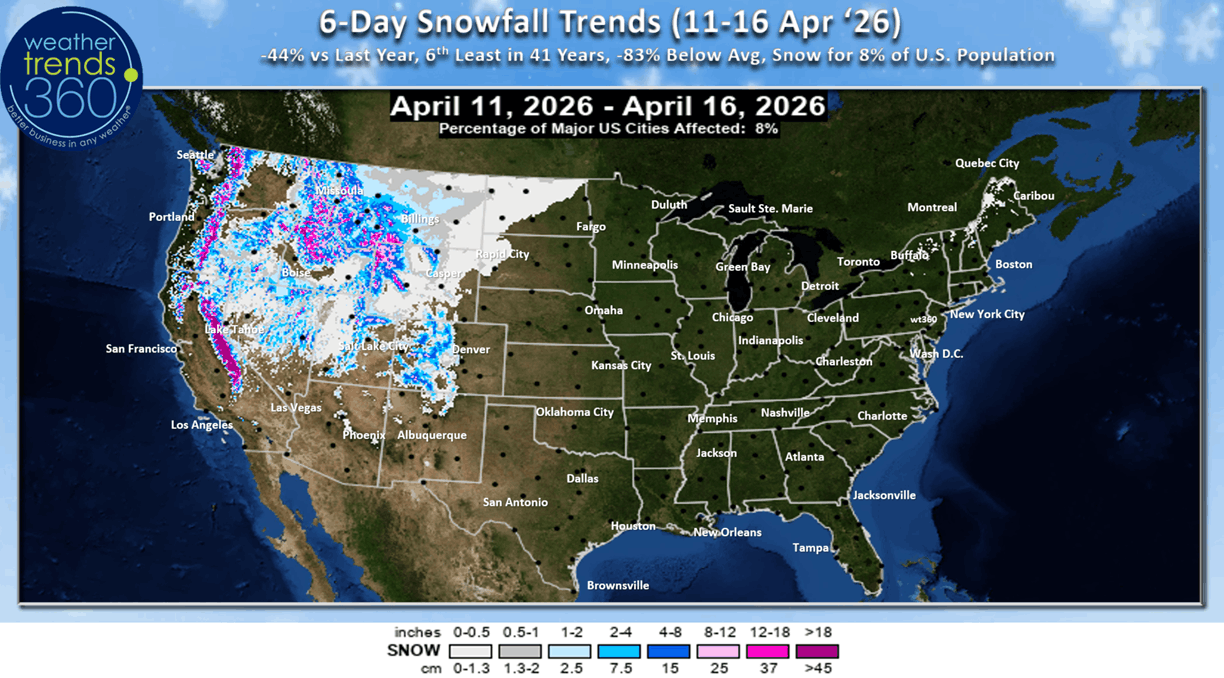
The 6-day snowfall outlook (11-16 Apr) shows heavy mountain snow in the West, but still down -44% vs last year nationally and only 8% of the U.S. population getting snow.
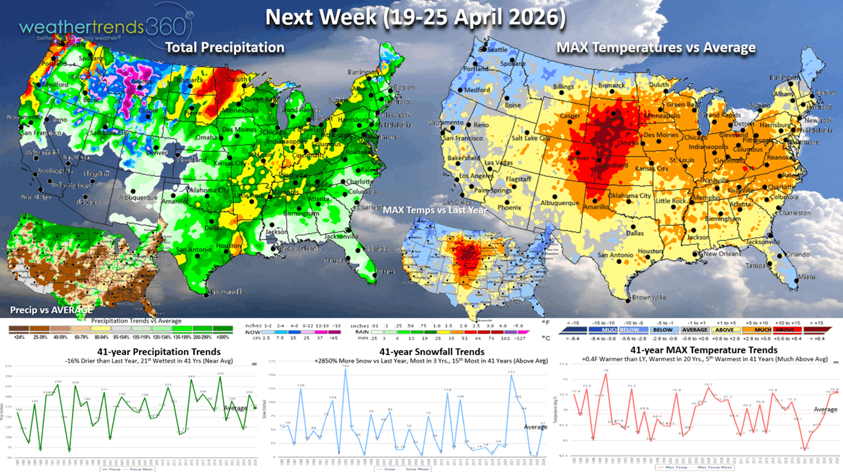
Next week (19-25 Apr) shows a moderating trend in the East with the heat shifting back into the Central Plains with the cool spot in the Pacific Northwest. The U.S. overall trends +0.4F warmer than last year, warmest in 20 years and 5th warmest of the past 41 years. Snowfall way up +28X vs LY, while rainfall is down -16% vs LY but still 21st wettest in 41 years. The Pacific Northwest and Northern Plains are the really wet and snowy spots. Southeast is still bone dry, year-to-date driest in over 41 years.

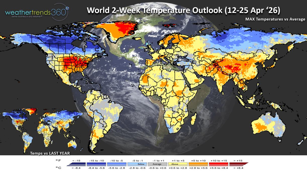
The World 2-week Temperature outlook (12-25 Apr) shows the same general theme of cold across Canada, warmer in the U.S. and Europe.

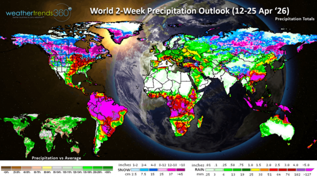
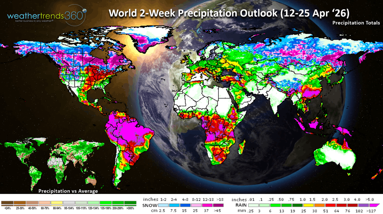
The World 2-week Precipitation outlook (12-25 Apr) shows continued wet conditions across Brazil and unusually snowy across Canada.
You can get this blog/video in your email inbox every Saturday (FREE) via subscription.
Have a great week ahead, and don't forget to follow us on social media for updates: Facebook, Twitter(X), YouTube, Pinterest and Linkedin.
- Captain Kirk out (USAF Gulf War Veteran 1989-1999)
Hawaii doesn't get much attention weather wise until they're hit with Kona low after Kona low bringing historic rainfall to the Islands, with year-to-date rainfall off the scale, the most in over 41 years. CLICK ON IMAGES FOR A LARGER VIEW.
A little Captain Kirk grew up in Kaneohe Hawaii at the base of the Ko'olau Mountains that went straight up nearly 3,000 feet where we averaged 125" of rain a year (most fell at night). But just 5 miles away at the Marine Corps Base they'd only get 16" and on the other side of the Island (Honolulu) they'd get about the same (16"/year). It's one of the most pronounced "rain shadow" effects in the World.
As we gear up for what appears to be a strong to potentially very strong El Niño later this year, the floods will turn to droughts in Hawaii going into next Winter, while the Continental U.S. gets VERY WET ending our years of dry to drought conditions. The Equatorial Pacific Ocean temperatures just below the surface are +6°C above average, we only need +1.5°C at the surface to get a strong El Nino, so odds are increasing for a major climate cycle shift.
Last week (5-11 April) across the World shows the U.S. trending +2.3F warmer than last year, 17th warmest of the past 41 years. This was a moderating trend from the extreme heat in late March. Snowfall was down -39% vs last year and 6th least in 41 years, while rainfall was down -33%, least in 6 years and 9th driest of the past 41 years. These are favorable trends for Spring merchandise sales after the not so favorable Easter weekend in the East. Continued cold in Canada, warmer across Europe, extremely wet and snowy across Russia and ample rain continuing for Brazil's 2nd crops.
Severe weather across the U.S. is down significantly vs last year's fast start with tornadoes down -42% vs LY, hail cases down -26% and wind cases down -34%.
This could change this week with a prolonged week long threat of severe weather in the Central U.S.

This week (12-18 April) shows Winter making a comeback in the West with a few days of Summer-like weather in the East midweek. The U.S. overall trends +4.7F warmer than last year, warmest in 24 years and 2nd warmest in 41 years. Snowfall down -23% vs last year, while rainfall is up +199% vs LY, most in 6 years and 13th wettest in 41 years. The drought continues in the Southeast while the conveyor belt of moisture plagues Texas to the Great Lakes.
The 6-day snowfall outlook (11-16 Apr) shows heavy mountain snow in the West, but still down -44% vs last year nationally and only 8% of the U.S. population getting snow.
Next week (19-25 Apr) shows a moderating trend in the East with the heat shifting back into the Central Plains with the cool spot in the Pacific Northwest. The U.S. overall trends +0.4F warmer than last year, warmest in 20 years and 5th warmest of the past 41 years. Snowfall way up +28X vs LY, while rainfall is down -16% vs LY but still 21st wettest in 41 years. The Pacific Northwest and Northern Plains are the really wet and snowy spots. Southeast is still bone dry, year-to-date driest in over 41 years.
The World 2-week Temperature outlook (12-25 Apr) shows the same general theme of cold across Canada, warmer in the U.S. and Europe.
The World 2-week Precipitation outlook (12-25 Apr) shows continued wet conditions across Brazil and unusually snowy across Canada.
You can get this blog/video in your email inbox every Saturday (FREE) via subscription.
Have a great week ahead, and don't forget to follow us on social media for updates: Facebook, Twitter(X), YouTube, Pinterest and Linkedin.
- Captain Kirk out (USAF Gulf War Veteran 1989-1999)