Weather Alert: Polar Vortex to Plunge Nation Into Deep Freeze - Snow Risks
Breaking Weather Events
Prolonged Period of Extreme Cold East of the Rockies Next Week With Wintry Precipitation Threats
Snow, ice, and cold will all be hazards next week; renewed wildfire risk in southern California late in the week
As we move through the heart of Winter, the weather is going to turn particularly hazardous across the nation. The Polar vortex will help to usher in some of the coldest weather of the season across a large portion of the nation east of the Rockies, and extreme cold will linger much of next week. With cold air in place, the threat for disruptive wintry precipitation increases, even in the Deep South. Additionally, we'll unfortunately be looking at another period of enhanced wildfire risk in southern California late next week.
Record and Prolonged Cold Incoming
Arctic air will plunge across the Rockies and Great Plains today (Friday) and reaches the Deep South and Great Lakes on Saturday behind a cold front that will bring just a touch of rain and snow. The cold reaches the Eastern Seaboard on Sunday where we'll be watching for a significant snowfall event.

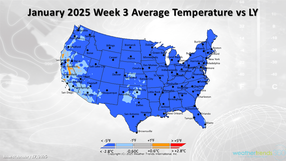
For the week-ending January 25th, this will be the 2nd coldest third week of January in 34 years for the nation as a whole and a wholesale change from last year's 3rd warmest in 34 years. The cold will linger much of the week making this one of the longest stretches of bitterly cold weather in decades.
Highs may only reach the single digits from Chicago to Pittsburgh during the first half of next week with lows below 0F and wind chills in the negative double-digits. Sub-freezing temperatures are likely to reach the Gulf Coast as well and into northern Florida with a risk to citrus crops. The presidential inauguration, which takes place on Monday, January 20th in Washington D.C., will likely be one of the coldest in decades.
Expect double-digit year-on-year increases in demand for items like auto batteries which are more likely to fail in extreme cold, especially after enduring a hot summer last year. Home service calls are likely to skyrocket for emergency 'no heat' calls and frozen pipes. Space heaters are likely to see a surge in the South where home heating systems are not typically equipped to handle this type of cold. Expect consumers to hunker down at home, which will take a bite out of in-store traffic, especially for open air centers.
Snow and Ice Threats
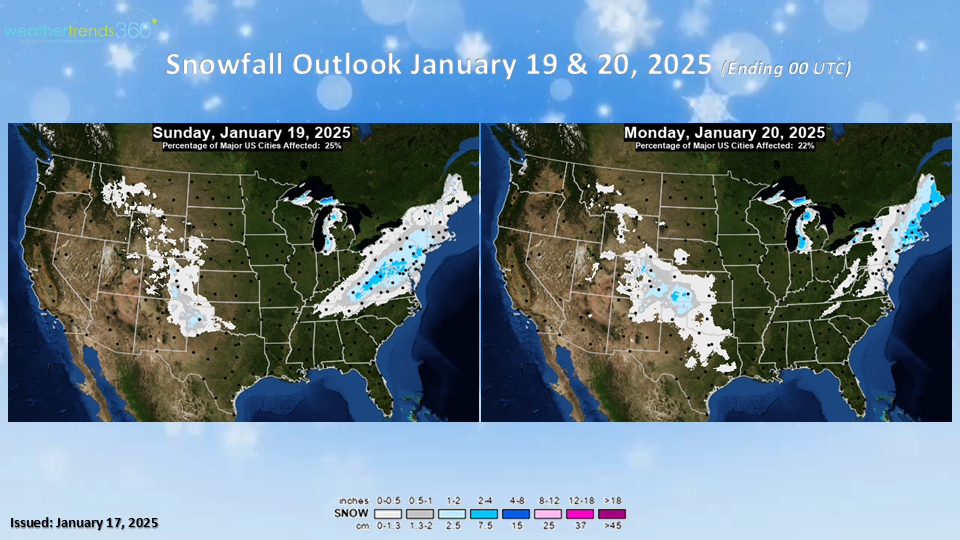
As cold air rushes in behind a cold front on Saturday, which will yield mainly non-eventful amounts of rain and snow across the East, the threat for disruptive wintry precipitation will increase. On Sunday, a storm develops and brings the threat of +6'' of snowfall to the major metropolitan areas along the I-95 corridor from the Mid-Atlantic to the New England with the potential for over a foot of snow.

This would negatively affect store traffic most of the day Sunday. Demand for storm staples like milk, bread, and eggs will be strong Saturday. Of course, changes in the storm track (east or west) or forward motion of the storm will alter the outcome.
Deep South Snow Risk?
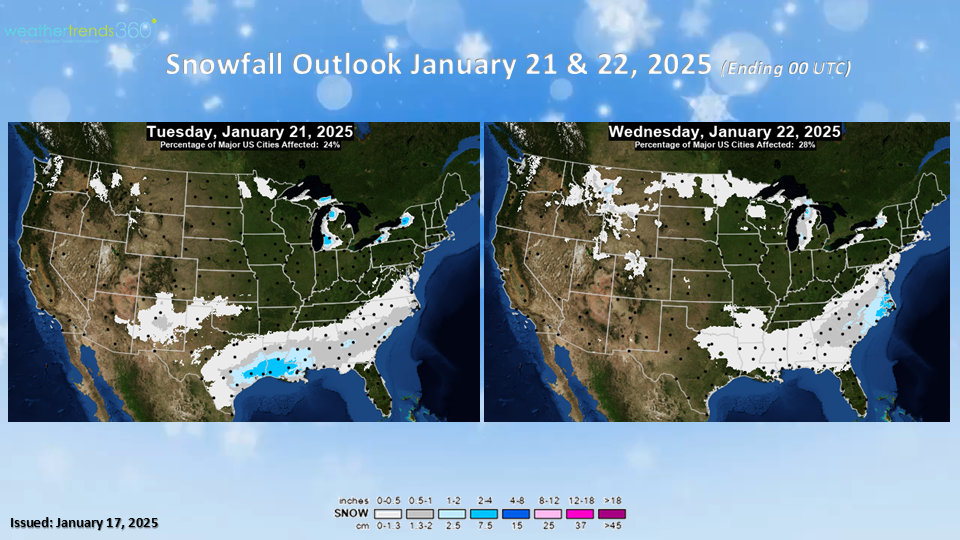
As the Northeast cleans up from the late weekend storm, the Deep South could be preparing for a substantial, possibly historic, snowstorm themselves. Currently, the threat for significant wintry precipitation exists from Houston to New Orleans and into northern Florida from Tuesday to Wednesday.

There will probably be a shift north or south with this system between now and then, but models have been persistent over the past several days on a storm for the Deep South. Significant, perhaps even plowable, snow and heavy freezing rain are a possibility. This would be debilitating for this region with both travel being disrupted as well as the potential for power outages.
With many homes not equipped to handle the extreme cold that will be in place, this will be a big concern for the region. Over the coming days expect increased demand for things like generators, non-perishable foods, batteries, bottled water, and even things like camp stoves can see increased demand if power goes out. Snow and ice removal categories will also see increased demand.
Wildfire Threat Reignites in Southern California
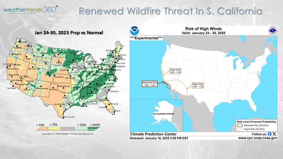
Southern California will experience its own set of weather challenges in the days ahead as the wildfire risk increases once again. Another Santa Ana wind event is possible in the period from January 24th to the 30th. Strong winds and dry conditions will lead to conditions ripe for rapid wildfire growth and spread. This will be a huge difference from last year when heavy rainfall caused flooding in southern California.
