Warm & Stormy Weather Forecast for March 2021
Captain's Log
Happy Monday! :)
Folks along the East Coast were surprised to see an Elon Musk Falcon 9 rocket launch light up the night sky early Sunday morning. Timing was perfect to see the rocket move north along the East Coast to release 60 more Starlink satellites. CLICK ON IMAGES FOR A LARGER VIEW.

The World recap for last week (7-13 March) shows the U.S. having a good week for early Spring merchandise sales with temperatures trending -0.8F cooler than last year but still much above average nationally with the 7th warmest 2nd week of March in 36 years. Rainfall was 59% less than last year and 2nd driest in 36+ years while snowfall was also the least in 5 years and 5th least in 36 years.
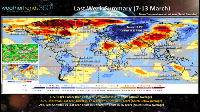
Canada was +7.2F warmer than last year with nearly coast-to-coast mild conditions, Europe was the cold spot keeping seasonal sales soft with temperatures trending 7.5F colder than last year and coldest in 8 years. Russia was in the heart of the Polar Vortex trending coldest in 21 years. Brazil also the coldest in 35 years while China, India and Australia all trended warmer.
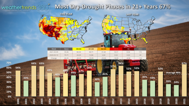
Dry-to-Drought phases across the U.S. are now at 21+ year highs with 67% of the country dry vs near historic wet conditions last year when only 24% of the country was trending dry. Some improvement likely over the next couple weeks but the dry trends will resume April into June.
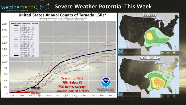
Tornadic activity is at 6 year lows and trending 75% below average and below last year. Some severe weather likely this week in the Southeast.
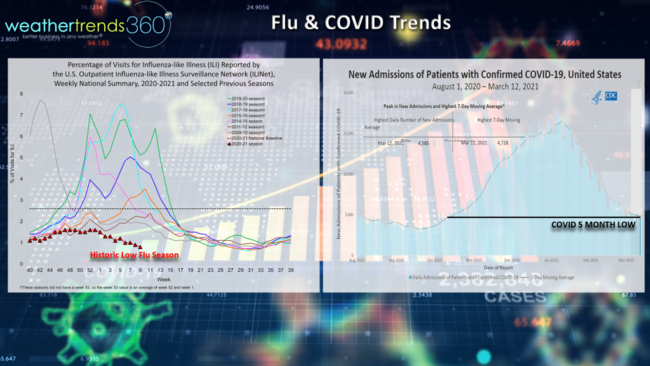
The other thing trending down - both Flu and COVID! Some research confirms that it's unusual to have two major pandemic viruses at the same time, in part explaining why Flu is at historic lows. The really warm Fall last year and kids social distancing and remote learning certainly played a role as well. The good news, both are trending down with COVID cases at 5 month low.
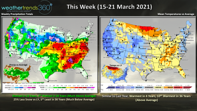
This week (15-21 March) shows the coasts are the colder spots while a warm up takes shape in the Upper Plains and East Central U.S. This week nationally trends similar to last year but still warmest in 4 years, 10th warmest in 36 years. Rainfall picks up trending wettest in 18 years as the big Rockies storm finally moves out. Despite the Rocky snow storm, national snowfall is still 25% less than last year and 5th least in 36 years.
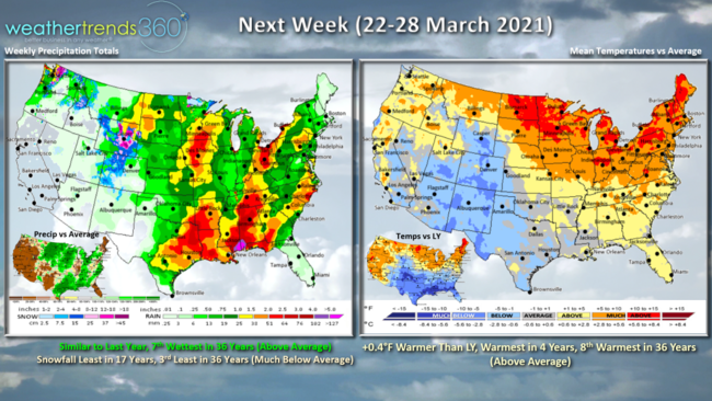
Next week (22-28 March) another big warm surge for the Northern tier and Eastern U.S. with national temperatures trending the warmest in 4 years and 8th warmest of the past 36 years. Rainfall again on the wet side trending 7th wettest of the past 36 years while snowfall is the least in 17 years, 3rd least in 36 years. More severe weather potential in the Southeast next week.
Spring officially arrives Saturday at 5:37am EDT!
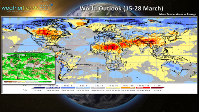
The 2-week World aggregate (15-28 March) shows moderating trends across Europe and Russia while it cools off in Australia as they start Fall.
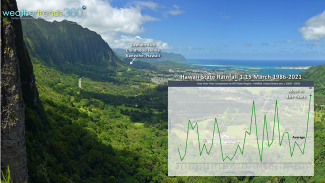
Hawaii doesn't frequently make headline news on the weather front, but they are here for the front half of March that has been near historic wet! March is off to the wettest start across the Islands in over 36 years.

As a little Captain Kirk growing up in Kaneohe, Hawaii on the Island of Oahu at the base of the Kool'au Mountains, I recall a 100" rain storm in ONE WEEK that was the catalyst for getting me excited about science and meteorology. 7 years ago was a lot drier when we got married in the very spot I used to play in the sand building sand castles! Happy 7-year anniversary to Mrs. Simona Captain Kirk. :)
Have a great week and don't forget to follow us on social media for frequent updates: Facebook, Twitter, YouTube, Pinterest and Linkedin
- Captain Kirk out.