Tropics Update: Potential Tropical Storm to Impact Florida This Week
Scientific Meteorology
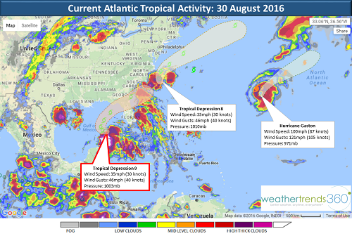
The Atlantic remains quite active today. Hurricane Gaston, currently a Category 2 hurricane with winds of 100mph, remains over open waters and will not have any impact on the United States. Over the weekend, however, 2 disturbances were upgraded to Tropical Depression status. Tropical Depression 8, which currently has sustained winds of 35mph, is located just off the North Carolina coast and is expected to turn north-northeastward and head back out to sea. While Hurricane Gaston and Tropical Depression 8 will have little to no impact to the US, the story changes when we talk about Tropical Depression 9.
Currently located in the Gulf of Mexico just north of western Cuba and Mexico's Yucatan Peninsula, Tropical Depression 9 is once again expected to strengthen as westerly wind shear decreases and convection increases. While conditions do not currently suggest this system will reach hurricane strength, there is a very high probability that TD9 will become Tropical Storm Hermine sometime this week. While there is always some uncertainly with the path of the storm, Hermine is expected to make landfall on Thursday in Florida's Big Bend Coast, bringing heavy rain and winds to the region. Retailers in the area should expect a surge in store traffic at big box stores and home centers as consumers prepare for the storm. Batteries, flashlights, bottled water, generators, and other emergency supplies will see a higher demand. After the system passes over Florida, rains can be expected along the southeastern coast as well. Where the system heads to from there is where the most uncertainty lies, but current projections suggest it will head out to sea, similar to TD8.

Remember, this hurricane season is going to be more active than normal and we expect more storm development over the next couple weeks in the Atlantic. We're already monitoring a weak area of low pressure associated with a tropical wave just off Africa's west coast that could gradually develop as it moves further into open waters. September is the climatological peak of hurricane season.
Guest Blog by Meteorologist Pamela Remetta
Currently located in the Gulf of Mexico just north of western Cuba and Mexico's Yucatan Peninsula, Tropical Depression 9 is once again expected to strengthen as westerly wind shear decreases and convection increases. While conditions do not currently suggest this system will reach hurricane strength, there is a very high probability that TD9 will become Tropical Storm Hermine sometime this week. While there is always some uncertainly with the path of the storm, Hermine is expected to make landfall on Thursday in Florida's Big Bend Coast, bringing heavy rain and winds to the region. Retailers in the area should expect a surge in store traffic at big box stores and home centers as consumers prepare for the storm. Batteries, flashlights, bottled water, generators, and other emergency supplies will see a higher demand. After the system passes over Florida, rains can be expected along the southeastern coast as well. Where the system heads to from there is where the most uncertainty lies, but current projections suggest it will head out to sea, similar to TD8.

Remember, this hurricane season is going to be more active than normal and we expect more storm development over the next couple weeks in the Atlantic. We're already monitoring a weak area of low pressure associated with a tropical wave just off Africa's west coast that could gradually develop as it moves further into open waters. September is the climatological peak of hurricane season.
Guest Blog by Meteorologist Pamela Remetta