Snow Season Totals from 2016-2017
Did You Know?
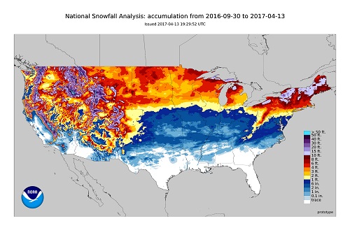
Depending on where you live, this winter season was feast or famine in terms of snowfall. Parts of New England saw one of their snowiest winters on record, but areas just to the south received below average snowfall. Below average snowfall was common across the Midwest, but snowfall was above average in the far northwestern Plains. And if you haven't heard, snowfall in the West was completely BONKERS! (not a scientific term).
Northeast
On the whole, snowfall trended greater than last year for the Northeast but snowfall was still the 8th least in 26+ years. Over a relatively small distance, snowfall for the season goes from above average to below average. The dividing line is somewhere near weathertrends360 headquarters in Allentown, PA where snowfall was the 11th least in 26+ years. Just 50 miles to our north, however, Wilkes-Barre, PA saw their 7th snowiest winter season in 26+ years.
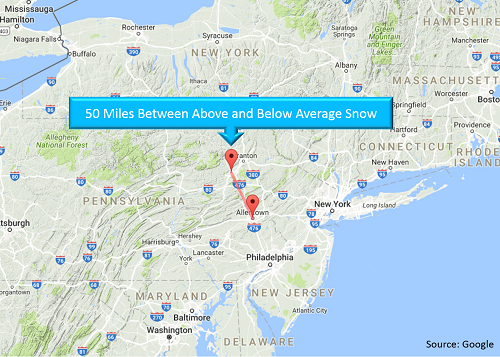
Generally speaking, above average snowfall was confined to New England (New York state and northeastward). The swath of above average snowfall was bounded by below average snowfall in places like Buffalo, NY and Toronto, ON while above average snowfall stretched from eastern New York state up into Newfoundland where they received incredible amounts of snow.
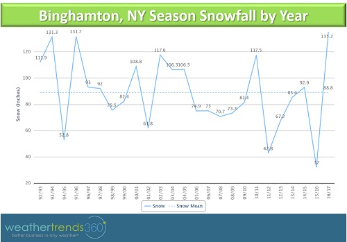
Binghamton, NY is the winner in terms of snowfall for the Northeast Region as this was the snowiest winter season on record for the city. Lake Effect snow during mid-November dumped roughly 21% of the season's total snowfall on Binghamton as about 2' of snow fell in a couple of days. While the infamous mid-March Nor'easter brought 26% of the season's total snowfall to the city (that was almost 3' of snow), and the storm set a new record for the most snow in a 24 hour period as 31.3'' of snow fell between March 14th and 15th. Interestingly, last year was the least snowiest winter season on record. What a difference a year makes!
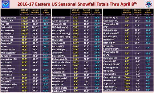
The Northeast region's "loser" in terms of snowfall was Baltimore, MD where this was the 3rd least snowy winter in 26+ years with only 3'' of snow.
Midwest
If you love snow, then hopefully you didn't live in the Midwest this past winter. Largely, the region's snowfall was below average as snow was the 2nd least in 26+ years for the region as a whole. Snowstorms were few and far between.
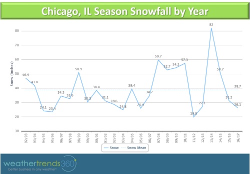
Snowfall by the end of December ran almost 10'' above average for that point in the season in Chicago. However, the months of February and January went by with nothing more than a couple of light snow showers. In fact, Chicago saw about 68% of the season's total snowfall by the time Christmas rolled around, but less than an inch of snow fell between December 19th and March 11th. For the season overall, snowfall was the 6th least in 26+ years for Chicago.
While most of the region saw below average snowfall, there was a spot of above average snowfall in central and western North Dakota. In Bismarck, this was the 6th snowiest winter season in 26+ years, while Fargo, about 200 miles east of Bismarck, saw the 5th least snow in 26+ years.
West
The West is still racking up snow totals but it's pretty safe to assume that parts of the Sierras and Cascades saw record snowfall this season. Mammoth Mountain, CA may be called "mammoth" for reasons other than snowfall, but this year we'll give it the award for the 'Most Mammoth Amount of Snow' with almost 600'' of snow and counting. This season featured an unusually stormy weather pattern with, at times, seemingly endless plumes of moisture off of the Pacific.
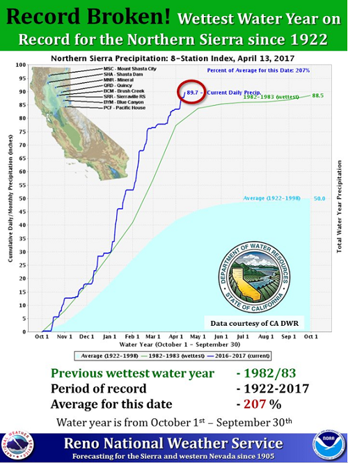
Snow and rainfall was particularly heavy for the northern Sierras. When looking at the northern Sierra water year (which runs from October 1st to September 30th), this water year has already broken the record for wettest on record (see chart below). This is incredible as we still have about 5 months to go in the water year.
Even the cities in the Pacific Northwest, where it's common to go an entire season with little to no snow, has gotten in on the frosty action. This was the 2nd snowiest winter in 26+ years for Seattle, WA and Salem, OR, and the 3rd snowiest for Portland, OR and Pendleton, OR. Snowy conditions extended into Boise, ID where this was the snowiest winter in 26+ years with 39.5'' of snow. Boise is about 2'' shy of the all-time record, however, they've already passed their average last day for snowfall in the season, although snow has fallen into the month of May in Boise.
Snow totals were near normal down around Salt Lake City, UT and Casper, WY, but as we head even farther south, snowfall versus average drops off considerably. In Denver, this has been the least snowy winter in 26+ years with only 19.4'' of snow. In the absence of any further snow this year, this would be an all-time record for least snow in a season. However, the average last snowfall date in Denver is April 26th so there is still time for this record to be undone.
South
There's not much to say about snowfall in the South as a majority of the region saw no or below average snowfall. Snow was the least in 26+ years for the South Central U.S. and the 3rd least in 26+ years for the Southeast.

Northeast
On the whole, snowfall trended greater than last year for the Northeast but snowfall was still the 8th least in 26+ years. Over a relatively small distance, snowfall for the season goes from above average to below average. The dividing line is somewhere near weathertrends360 headquarters in Allentown, PA where snowfall was the 11th least in 26+ years. Just 50 miles to our north, however, Wilkes-Barre, PA saw their 7th snowiest winter season in 26+ years.

Generally speaking, above average snowfall was confined to New England (New York state and northeastward). The swath of above average snowfall was bounded by below average snowfall in places like Buffalo, NY and Toronto, ON while above average snowfall stretched from eastern New York state up into Newfoundland where they received incredible amounts of snow.
Binghamton, NY is the winner in terms of snowfall for the Northeast Region as this was the snowiest winter season on record for the city. Lake Effect snow during mid-November dumped roughly 21% of the season's total snowfall on Binghamton as about 2' of snow fell in a couple of days. While the infamous mid-March Nor'easter brought 26% of the season's total snowfall to the city (that was almost 3' of snow), and the storm set a new record for the most snow in a 24 hour period as 31.3'' of snow fell between March 14th and 15th. Interestingly, last year was the least snowiest winter season on record. What a difference a year makes!

The Northeast region's "loser" in terms of snowfall was Baltimore, MD where this was the 3rd least snowy winter in 26+ years with only 3'' of snow.

Midwest
If you love snow, then hopefully you didn't live in the Midwest this past winter. Largely, the region's snowfall was below average as snow was the 2nd least in 26+ years for the region as a whole. Snowstorms were few and far between.
Snowfall by the end of December ran almost 10'' above average for that point in the season in Chicago. However, the months of February and January went by with nothing more than a couple of light snow showers. In fact, Chicago saw about 68% of the season's total snowfall by the time Christmas rolled around, but less than an inch of snow fell between December 19th and March 11th. For the season overall, snowfall was the 6th least in 26+ years for Chicago.

While most of the region saw below average snowfall, there was a spot of above average snowfall in central and western North Dakota. In Bismarck, this was the 6th snowiest winter season in 26+ years, while Fargo, about 200 miles east of Bismarck, saw the 5th least snow in 26+ years.
West
The West is still racking up snow totals but it's pretty safe to assume that parts of the Sierras and Cascades saw record snowfall this season. Mammoth Mountain, CA may be called "mammoth" for reasons other than snowfall, but this year we'll give it the award for the 'Most Mammoth Amount of Snow' with almost 600'' of snow and counting. This season featured an unusually stormy weather pattern with, at times, seemingly endless plumes of moisture off of the Pacific.
Snow and rainfall was particularly heavy for the northern Sierras. When looking at the northern Sierra water year (which runs from October 1st to September 30th), this water year has already broken the record for wettest on record (see chart below). This is incredible as we still have about 5 months to go in the water year.

Even the cities in the Pacific Northwest, where it's common to go an entire season with little to no snow, has gotten in on the frosty action. This was the 2nd snowiest winter in 26+ years for Seattle, WA and Salem, OR, and the 3rd snowiest for Portland, OR and Pendleton, OR. Snowy conditions extended into Boise, ID where this was the snowiest winter in 26+ years with 39.5'' of snow. Boise is about 2'' shy of the all-time record, however, they've already passed their average last day for snowfall in the season, although snow has fallen into the month of May in Boise.
Snow totals were near normal down around Salt Lake City, UT and Casper, WY, but as we head even farther south, snowfall versus average drops off considerably. In Denver, this has been the least snowy winter in 26+ years with only 19.4'' of snow. In the absence of any further snow this year, this would be an all-time record for least snow in a season. However, the average last snowfall date in Denver is April 26th so there is still time for this record to be undone.
South
There's not much to say about snowfall in the South as a majority of the region saw no or below average snowfall. Snow was the least in 26+ years for the South Central U.S. and the 3rd least in 26+ years for the Southeast.