Review of the 2020-2021 Polar Vortex
Captain's Log
Happy Monday! :)
A recap of the U.S. Fall - Winter shows the very warm end to Fall, not so bad front 66% of Winter, 16 days of epic Polar Vortex in middle February and now the warmest day in almost 3 months! CLICK ON IMAGES FOR A LARGER VIEW.
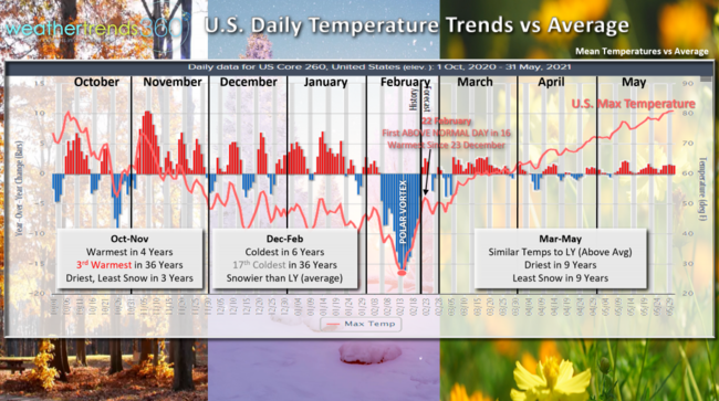
After the 3rd warmest late Fall in 36+ years, Winter had some brief intrusions in December and January before the bottom fell out in middle February as the Polar Vortex finally invaded the U.S.
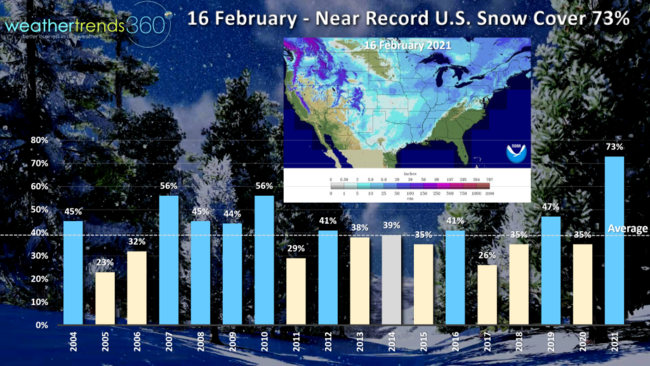
The middle February period was near historic cold for the U.S. overall along with 73% of the U.S. blanketed in snow, also a near record. The good news is today is the first day the U.S. will trend above average in 16 days and the warmest day since 23 December...we'll take it! The good news...a choppy start to March and April but late April into May could approach historic warm conditions, wholesale change from the past couple years...and driest least snow in 9 years!
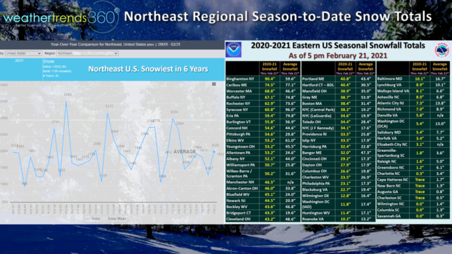
Season-to-date snowfall totals in the Northeast show big differences across small geographies which is common when a Polar Vortex camps out in the same spot for 2 weeks allowing a parade of storms to impact the same areas over-and-over. Here in PA, normally snowy Erie PA is trending 22" below average snow while Eastern PA is 28" above average. Southern New Jersey is 7" below average while northern NJ is 23" above. Even across Southern NY there are wild swings with Binghamton 30" above while Syracuse is 35" below.
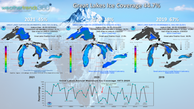
With the Polar Vortex invasion the Great Lakes had a big uptick in ice coverage with 45% now covered in ice, up from only 18% last year but down from 67% back in 2019. Ice coverage has been as high as 95% so we're just about average.
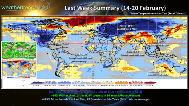
Last week (14-20 February) the U.S. trended a whopping 12.6F colder than last year and #1 coldest in over 36 years with hundreds of 125 year record low temperatures. Rainfall was 66% more than last year, 9th wettest in 36 years while snowfall was the #1 most in over 36 years, up 443% over last year. A huge negative for retail sales and early Spring merchandise that got off to a very fast start last year with the warmer and drier February.
Europe and Russia were both the coldest in 10 years with a huge change in temperatures compared to last year. Cool Summer conditions continue down under in Australia with the coolest late February weather in 12 years.
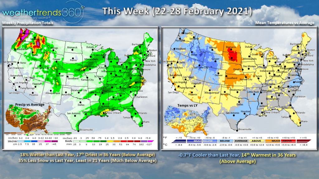 This week (22-28 February) across the U.S. shows temperatures trending 0.7F cooler but still 14th warmest of the past 36 years and above average for the first time since late January. Snowfall looks to be the least in 21 years, but another moderate event moving through the Northeast early in the week before milder conditions set up.
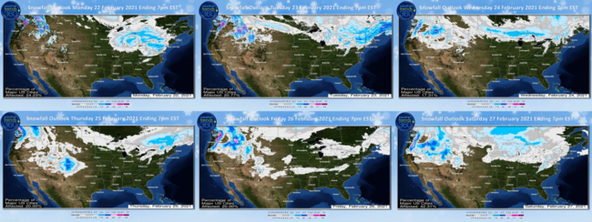
The 6-day snowfall outlook shows the snow beginning to diminish as the Polar Vortex lifts out.
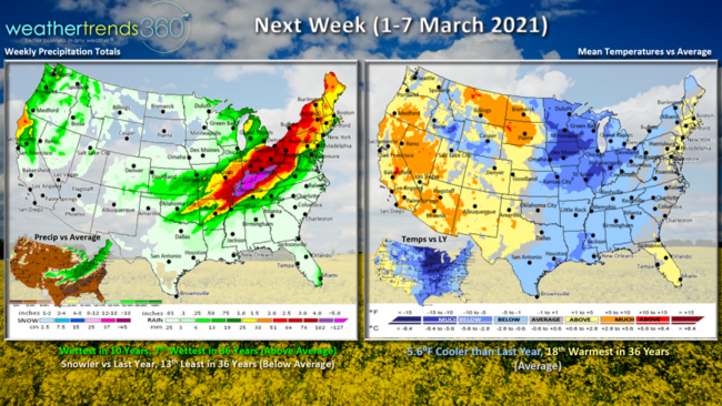
Next week (1-7 March) is the official start of "Meteorological Spring" with a more transient weather pattern setting up. Last year March was the 3rd warmest in history, so the trends will be cooler this March for the U.S. overall but still likely to end up above average. Nationally temperatures week 1 trend 5.6F cooler than last year but still 18th warmest of the past 36 years (average). Wettest in 10 years but snowfall trends below average.
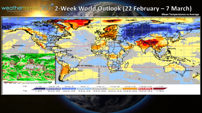
For the World overall, the 2-week outlook shows the cold hanging on in Russia and Siberia but a general moderating trend in the U.S. and especially Europe.
Have a great week, and don't forget to follow us on social media: Facebook, Twitter, YouTube, Pinterest and Linkedin
- Captain Kirk out.