Record Cold Weather in the Northeast
Captain's Log
Happy Monday! :)
Not so happy if you like Summer, as that ends tomorrow morning at 9:30am EDT (Tuesday 2 September). Fortunately the weather pattern shows a big warm up, so still time to enjoy a couple more trips to the beach or lake with a warmer/drier core Fall season. CLICK ON IMAGES FOR A LARGER VIEW.
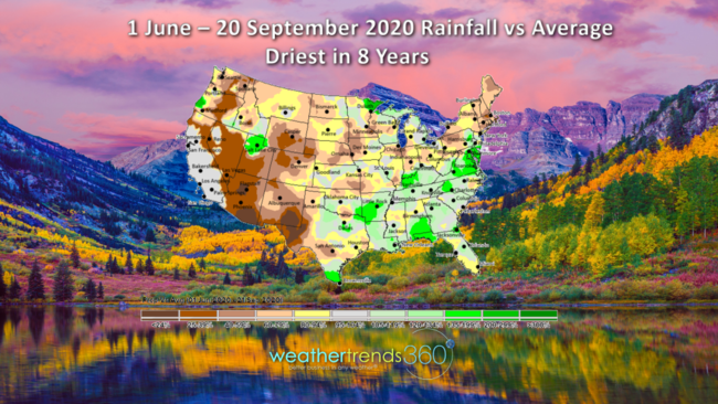
With Summer trending the driest in 8 years as expected, WTI warned of this last Fall and it happened, Fall foliage could be spectacular this year in many areas. Drier Summers can result in beautiful Fall color so the Northeast would be one top pick for a gorgeous Fall. Assumes no major wind storms bring the leaves down too early.
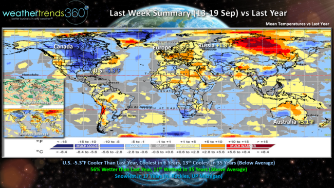
Last week (13-19 Sept) across the World vs last year showed the Eastern U.S. and Canada both much colder than a year ago and well below average. Europe turned very warm as did Australia about to enter their Spring season. For the U.S. overall, the week trended 5.3F cooler than last year, coldest in 6 years and 13th coldest in 35 years while rainfall was 56% more than a year ago but only due to Hurricane Sally in the Southeast. Much of the rest of the country was very dry.
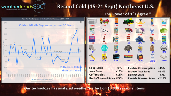
The Northeast U.S. had the coldest middle September period if over 35 years with many record low temperatures in the 20s and 30s bringing an end to the growing season. Our Power of 1 Degree technology quantifies how weather influences seasonal category sales and this was a benefit to many early Fall items. 9 degrees colder x 2% for coffee sales would mean an 18% increase in sales just due to weather. Unfortunately your electric consumption was also way up as we turned on our heat for the first time translating to a 45% increase in consumption, way up over two years ago when middle September was record hottest in 125 years.
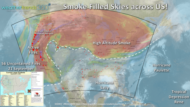
The good news is the cold front helped to push out the very smoky skies that plagued much of the northern half of the U.S. last week. Skies when from a very milky thick brown color to clear blue over the weekend here in the Northeast. There are still 56 uncontained fires in the West so smoky skies will be a big problem in the U.S. this Fall. With warm, drier conditions for October and November, we're very likely going to have a really bad allergy, Asthma and pollution season across the U.S.
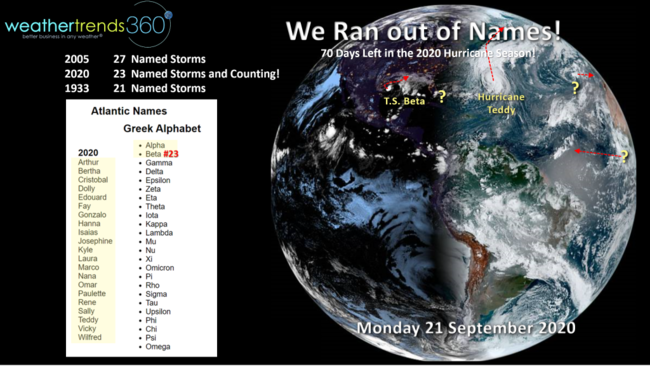
The other thing we'll be battling this Fall is an active hurricane season that is already the #2 most active season in 169 years with 23 named systems. The National Hurricane Center ran out of the normal 21 names, so we're using the Greek Alphabet to name the systems for the balance of the 2020 season. Very likely we crush the record 2005 years which had 27 named systems. There are still 70 days left in the hurricane season, so the threats to the U.S. are very likely going to continue well into early November. Still concerned about Florida and New England.
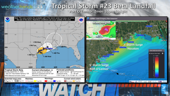
Fortunately Tropical Storm #23 Beta is relatively weak but also a slow mover meaning rainfall will be the biggest impact. There is a moderate storm surge of 5-7 feet with Beta from Port Arthur TX to Houston due to a long Southeast fetch. Waves are not that large with Beta but very large with Hurricane Teddy to the East of Bermuda. Large swells of 5-10 feet will impact the entire East Coast early this week before Teddy makes landfall in Southeast Canada.
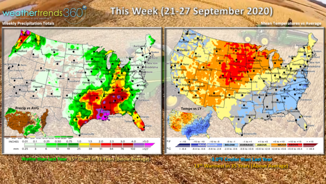
This week (21-27 September) trends 3.0F cooler than last year but still 13th warmest of the past 35 years. Temperatures will warm up significantly in the Northeast by midweek with very hot conditions in the Southwest and upper Plains. While wetter than last year due in part to T.S. Beta, the U.S. looks to trend 15th driest in 35 years.
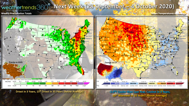
Next week (28 Sep - 4 Oct) also trends 3 degrees colder than a year ago, coolest in 3 years but 10th warmest of the past 35 years. Temperatures cool a bit in the East, but not as cold as this past weekend. Still much colder than this time last year from Texas to New York while the Western 2/3rds of the country bakes. Rainfall looks to trend driest in 3 years, 15th driest in 35 years.
Enjoy Fall, and don't forget to follow us on social media for frequent updates: Facebook, Twitter, YouTube, Pinterest and Linkedin
- Captain Kirk out