Quick Weekend Snowfall in the Northeast
Business
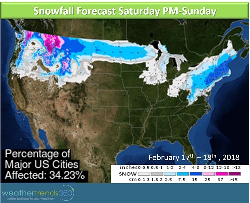
Confidence has increased for a light to moderate snow event along the I-95 corridor from Washington D.C. to Boston over the weekend. Snowfall will generally range from 1 to 6'' across this region.
The snow will start Saturday late afternoon/evening across Maryland and southern Pennsylvania and New Jersey. In the evening and overnight hours, the snow will spread up across the rest of the I-95 corridor, including New York City and Boston. Luckily, the snow will fall primarily in the night time hours so store traffic shouldn't be disrupted during the morning and early afternoon hours on Saturday. Demand for storm staples like milk, bread, and eggs will see an uptick today and into the first part of the day on Saturday. Store traffic should start to drop off as the sun goes down and the snow starts to fall late Saturday afternoon/evening.
The good news is that the snow will be over by sunrise on Sunday for most of the area. Sunshine and milder temperatures during the day on Sunday will help to quickly clear roadways, so store traffic impacts will not be prolonged.

After this shot of winter, we'll see the return of spring-like temperatures by Tuesday and Wednesday of next week across the East Coast. With temperatures in the 60s and possibly even 70s in the Northeast. But don't expect this to be a sign of things to come as the weather pattern going into early March supports a return to colder and potentially snowier conditions.
The snow will start Saturday late afternoon/evening across Maryland and southern Pennsylvania and New Jersey. In the evening and overnight hours, the snow will spread up across the rest of the I-95 corridor, including New York City and Boston. Luckily, the snow will fall primarily in the night time hours so store traffic shouldn't be disrupted during the morning and early afternoon hours on Saturday. Demand for storm staples like milk, bread, and eggs will see an uptick today and into the first part of the day on Saturday. Store traffic should start to drop off as the sun goes down and the snow starts to fall late Saturday afternoon/evening.
The good news is that the snow will be over by sunrise on Sunday for most of the area. Sunshine and milder temperatures during the day on Sunday will help to quickly clear roadways, so store traffic impacts will not be prolonged.

After this shot of winter, we'll see the return of spring-like temperatures by Tuesday and Wednesday of next week across the East Coast. With temperatures in the 60s and possibly even 70s in the Northeast. But don't expect this to be a sign of things to come as the weather pattern going into early March supports a return to colder and potentially snowier conditions.