March Storm Threatens Northeast
Business
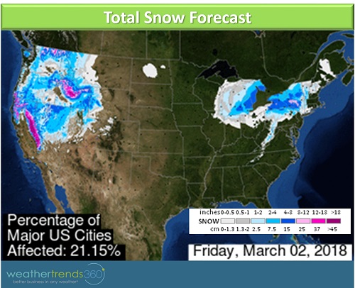
We're just 3 short weeks away from the official start of astronomical spring, but winter won't go away without a fight. March certainly looks like it's going to come in like a lion in the Northeast as a Nor'easter is set to wallop the region. While the major cities along the I-95 corridor in the Northeast look to be spared from any significant snow accumulations, locations in the interior Northeast, especially from the Finger Lakes in New York to the Catskills, could see upwards of a foot of snow. The other big story with this storm is going to be very strong winds which may cause power outages, especially as recent heavy rain has left the ground soggy which makes tress more vulnerable to toppling over. Coastal flooding will also be a large concern with this system.

The storm will first move across the Midwest and South bringing more heavy rain which will exacerbate the flooding situation across these regions. As the system heads east, snow will begin to fall across the southern Great Lakes on Thursday. Farther east, precipitation will begin as rain but cold air aloft will move in by Friday changing rain to snow first across the interior Northeast and in the higher elevations as the storm strengthens into a Nor'easter off the coast. Snow will eventually fall at lower elevations but warmer temperatures at the surface will prevent any major accumulations with perhaps a slushy inch or two in places like Philadelphia, New York City, and Boston.
Snow is expected through most of the day on Friday across New York state and the northern edge of Pennsylvania. Snow showers will linger in New England on Saturday as the Nor'easter will be slow to move away from the U.S. coast. Strong winds can be expected all the way down to North Carolina with gusts over 40 mph. Areas closer to the coast, especially Long Island and Cape Cod, could see damaging wind gusts over 60 mph.
Over a foot of snow is expected from southwestern New York state and the northern edge of Pennsylvania to the Finger Lakes of New York through the Catskills. Several inches of snow are expected in the Pennsylvania Pocono Mountains and in some of the higher terrain in northeastern Pennsylvania and just north and west of New York City. For the major I-95 cities themselves, there could be a slushy inch or two of accumulation.
IMPACTS: Store traffic will be disrupted on Friday and possibly into Saturday across the interior Northeast. Store traffic may see some disruptions due to heavy rain and then a slushy inch or two of snow accumulations in the densely populated I-95 corridor. Wind may also soften store traffic especially if power outages become an issue. Demand for storm related items like generators, batteries, flashlights, and bottled water should see an uptick over the next day or two in the Northeast ahead of the Nor'easter.
While we wish we could say that this was winter's final performance, there is another threat of a late season winter storm later next week.