February 2021 Nor'easter & Polar Vortex
Captain's Log
Good snowy morning! :) Welcome to February.
The 2nd big snow storm of the Winter season is plaguing the Northeast with a prolonged slow moving storm system for tens of millions of people. CLICK ON IMAGES FOR A LARGER VIEW.
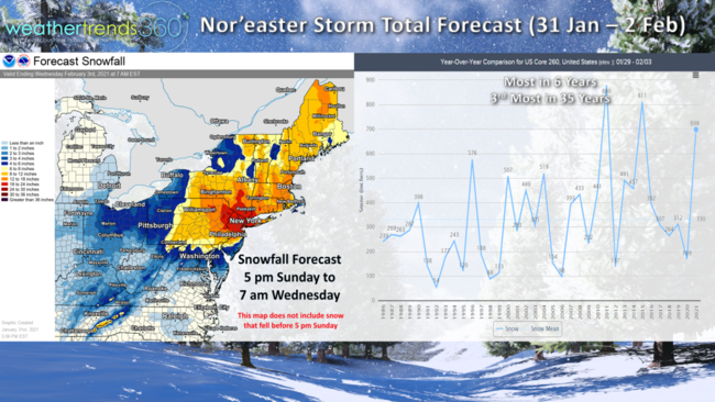
This storm has swept from California through the Midwest and now the Northeast making the late January - early February period the snowiest in 6 years, 3rd most in 35 years for the U.S. overall.
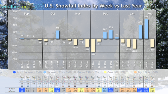
This will clearly be the snowiest week of Winter for the U.S. overall, trending +133% more than this time last year for the 31 Jan - 6 Feb period. The snowier weeks so far this season (for the U.S. overall) have been few with the middle October, middle December and now early February periods the better periods for Winter snow accessories.
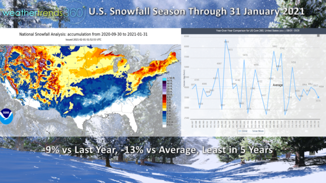
Season to date snowfall (1 Sep - 31 Jan) is trending 9% below last year and 13% below average and the least in 5 years for the U.S. overall. This 2021 Nor'easter will help to boost these numbers a bit.
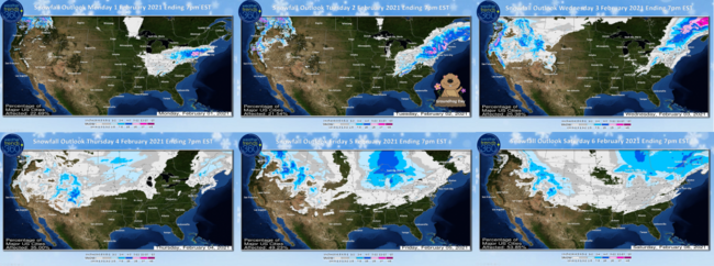
The 6-day snowfall outlook shows the snow exiting the Northeast late Tuesday as another weaker system traverses the northern tier of the U.S. and Great Lakes later in the week.
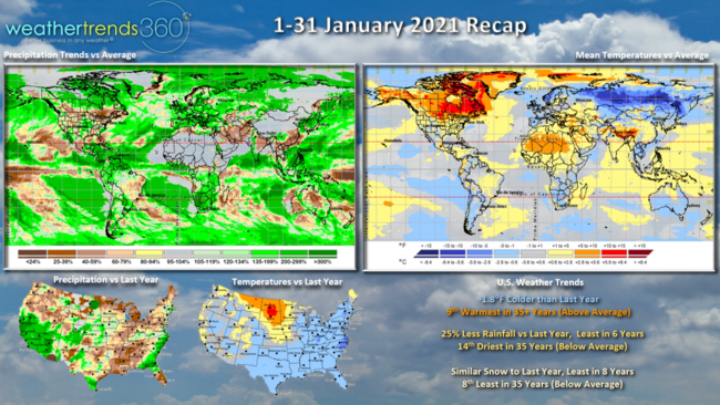
A recap of 1-31 January shows North America trending well above average in terms of temperatures with the cold spots across Europe, Russia, NE China and Australia. The U.S. trends vs last year show temperatures 1.8F colder than a year ago but still 9th warmest of the past 35 years. Rainfall was 25% less than last year, least in 6 years and 14th driest of the past 35 years for the U.S. overall. Snowfall was similar to last year but still least in 8 years and 8th least in 35 years, well below average.
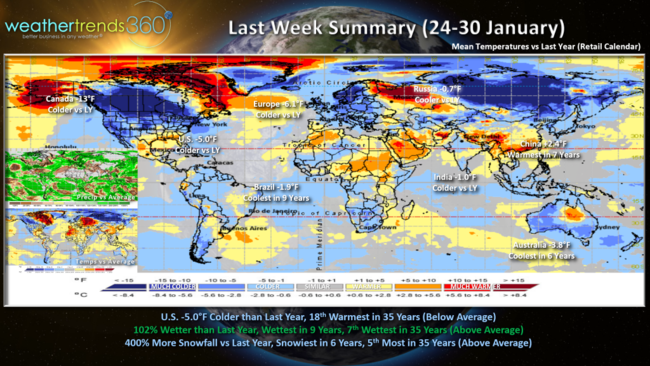
Last week (24-30 January) across the World shows the colder temperatures beginning to invade Canada and the U.S. Overall the U.S. trended 5F colder than a year ago to close out the month. Rainfall was 102% wetter, wettest in 9 years and 7th wettest in 35 years. Snowfall for the last week of January was up 400% over last year and snowiest in 6 years, 5th most in 35 years as a system traversed California to the Midwest to the Northeast.
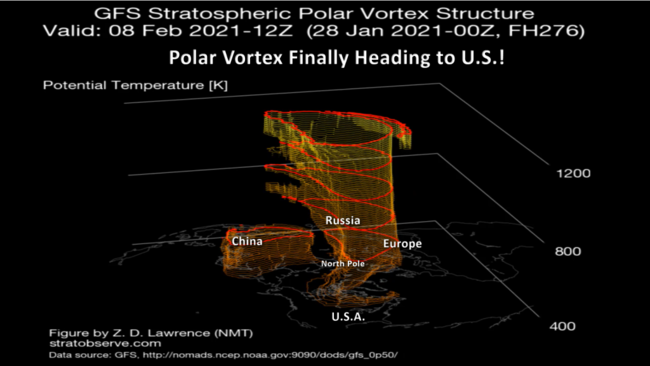
Now the weaker erratic 2021 Polar Vortex will FINALLY invade the U.S. after being absent most of the Winter ushering in the coldest weather of the season next week. Just as quick as the cold air comes in, it can exit allowing for a big warm up as it pulls out the 3rd week in February.
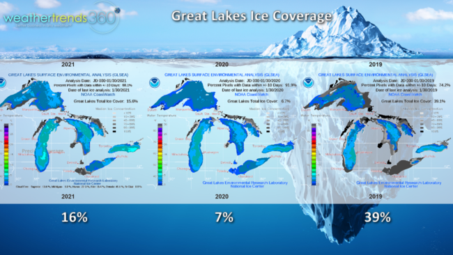
As the Polar Vortex ushers in sub zero temperatures this weekend into next week, expect Lake Effect snow downstream to be intense as the Great Lakes are still well below average ice coverage at 16%, up from last year's very low 7%.
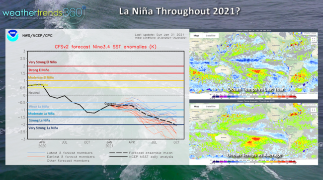
The other factor that will impact much of 2021 is La Nina which looks to hang around most of the year. This will ultimately lead to a dry cycle for many areas of the World including the U.S. as we go into Spring and Summer along with a very active and destructive hurricane season!
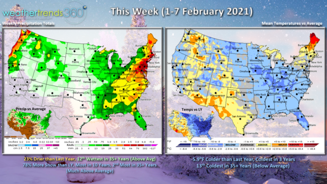
This week (1-7 February) across the U.S. trends 5.9F colder than last year, coldest in 3 years and 13th coldest of the past 35 years for the U.S. overall. Snowfall up 78% over last year, most in 10 years and 2nd most in 35 years, so this is a very strong week for Winter seasonal merchandise sales.
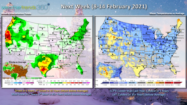
Next week (8-14 February) the Polar Vortex invades the Central and Eastern U.S. early in the week which will bring sub-zero temperatures to these areas. This will result in significant auto battery failures, very likely the peak week of the Winter season for this category. Temperatures will moderate later in the week going into the Valentine's Day-President's Day weekend.
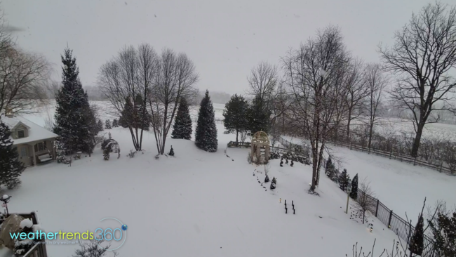
We'll end with the wintry scene here in Eastern PA - see the video if you're feeling left out on the snow...you can have some of ours!
Have a great week, and don't forget to follow us on social media for frequent updates: Facebook, Twitter, YouTube, Pinterest and Linkedin
- Captain Kirk out.