Fall 2020 Forecast Full of Hurricanes
Captain's Log
Happy Monday! :)
Can you believe there is just over a week left of Summer! :( Fall arrives next week Tuesday, but we've already had a taste of Fall in the Eastern half of the country and a taste of Winter in the Rocky Mountains with last week's record snow storm. CLICK ON IMAGES FOR A LARGER VIEW.

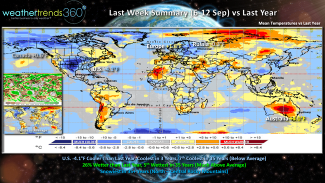
Last week (6-12 Sep) across the world showed the U.S. was 4.1F cooler than a year ago making it the coolest 2nd week of September in 3 years, 7th coolest in 35 years for the nation as a whole. Rainfall was up 26% over last year making it 5th wettest in 35 years. Obviously snowfall was near record shattering with all the snow in the Northern and Central Rockies with the snowiest conditions in 35+ years.
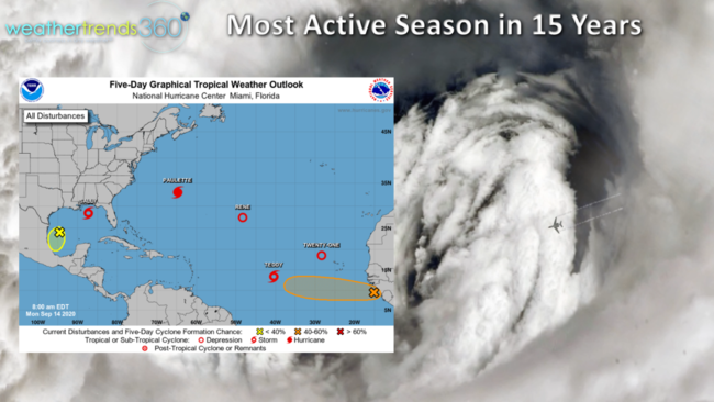
Here we go again in the North Central Gulf of Mexico with our 4th land-falling system tomorrow. Soon to be Hurricane Sally looks to make landfall in Mississippi this go around, just East of New Orleans. There are 7 tropical systems out there but for now Sally is the only one to impact the U.S. Cat 1 hurricane Paulette made landfall in Bermuda this morning and now moving away and likely to become a cat 2 hurricane. The next major hurricane potential is Tropical Storm Teddy but this one likely to pass East of Bermuda. As we saw with Sally, things can flare up in just days close in to the U.S. as we enter the peak period of the hurricane season (Sep-Oct).
The storm surge with Sally will be a bit wider with a slower moving system and prolonged Southeast wind fetch pilling up water in the bays and coastal areas.
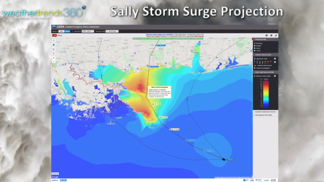
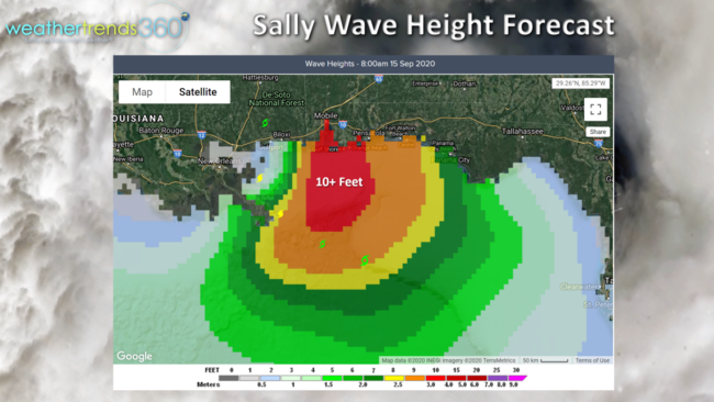
A storm surge of 7+ feet likely for much of Mississippi and Alabama Tuesday with 10-15 foot waves on top of that. The slow moving storm will also bring heavier rain this go around with some areas in MS-AL likely to get 12"+ totals.
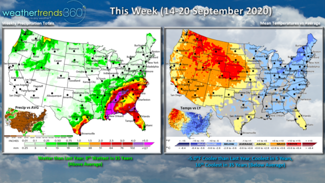
This week (14-20 Sept) looks to trend 5.0F cooler than last year, coolest in 6 years and 16th coolest of the past 35 years for the U.S. overall. Where it was Winter last week, we're back to HOT SUMMER weather in the Rockies, an amazing flip flop over the past two weeks going from record hot to a blizzard back to record hot. The cool weather in the East will be noticeable with the coolest conditions so far this late Summer period. While the U.S. is wetter than last year and 8th wettest in 35 years, that's all due to rainfall from Sally. Much of the rest of the country will have a very dry week.
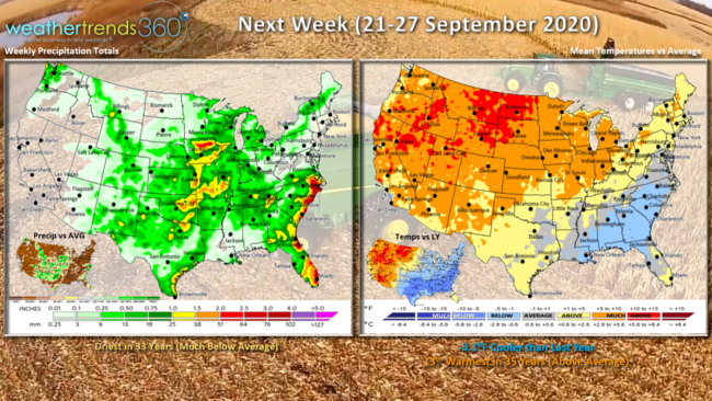
Next week (21-27 Sept) As projected a year ago the core Fall period of October and November would be warm and dry and that looks to start taking shape for this last full week of September. The U.S. overall looks to be driest in 35 years nationally and 13th warmest of the past 35 years. That's still 3.1F cooler than last year but going into October and November temperatures are more likely to start trending much warmer than a year ago. The dry conditions are good news for farmers starting to harvest the 2020 crop. It's been feast or famine in terms of rainfall but overall it's been the driest season in 7 years.
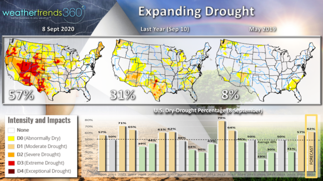
Dry to Drought conditions have expanded rapidly from last year's historic low drought with 57% of the country dry compared to only 31% this time last year and only 8% back in Spring 2019. WTI expects this dry cycle to last well into 2021 with potentially the worst drought since 2012 when nearly 80% of the country was in dry to drought phases. La Nina is just one of many cycles teaming up to crate this drier expanding pattern.
We had some fun in our studio last week with a colleague (John) helping us expand our capabilities into Russia, Europe and Asia. We were socially distant during filming, but it was good to be back in the office after 181 days being remote!

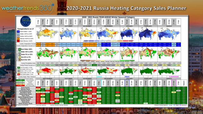
While most are used to high level seasonal forecasts that look like a weather map, Weather Trends actually produces a much more detailed weekly year-ahead forecast projecting temperature, rainfall, snowfall by week OUT A YEAR every mile on Earth. Our heating outlook across Russia shows the coldest conditions in 8 years, driest in 4 for the top 10 cities. We joke that we could tell you more on what we're up to, but then we'd have to have the aliens abduct you off the planet. ;) Yes we had fun and love what we do and the value we bring to so many businesses around the world.
Have a great week and don't forget to follow us on social media for frequent updates: Facebook, Twitter, YouTube, Pinterest and Linkedin
- Captain Kirk out