Extreme Cold Outbreak Could Impact Retail
Business
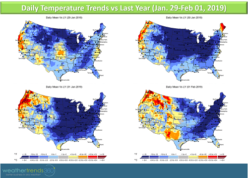
After a brief 'January Thaw' this past week, temperatures are set to take a significant plunge in the mid to later part of next week across the Midwest and Great Lakes. By Tuesday night (January 29th) temperatures will be plunging in the Midwest from -10F to as much as -40F colder compared to the same retail period of last year. The core of the cold air moves into the Ohio Valley and Northeast Wednesday night but moderates; while it will be cold, the severity of the cold won't be as great as what is seen in the Midwest or Great Lakes.
Cities Likely to be Affected By Severe Cold Include:
- Bismarck, ND
- Pierre, SD
- Duluth, MN
- Minneapolis, MN
- Omaha, NE
- Green Bay, WI
- Des Moines, IA
- Chicago, IL
- Indianapolis, IN
- Grand Rapids, MI
- Detroit, MI
- Cleveland, OH
- Buffalo, NY
Much colder temperatures than the comparable retail period of last year will extend farther south and east than the cities mentioned above with much of the eastern half of the nation enveloped in both colder than last year and colder than normal temperatures from middle to late part of next week. However, the cold won't be as severe or life-threatening in locations farther south and east. It's possible that freezing temperatures will once again touch parts of the Gulf Coast region.

Severe cold would negatively impact store traffic as consumers hunker down at home. Most categories would see softer sales, however, products like auto batteries, fire logs, and space heaters may be the few winners out of this severe cold event. The next several days will be a good time to clear out any remaining winter clearance categories on the shelf.
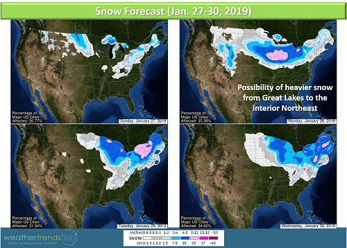
As far as snow concerns go, Lake Effect Snow will fall downwind of the Great Lakes over this weekend. A Clipper system will bring light to moderate snow from the northern Plains to the Midwest early next week. We'll have to monitor this system as it could bring some moderate to heavy snow to the Great Lakes and the interior Northeast during the first half of next week, ahead of the surge of very cold air.
