Cold & Snowy Forecast for March 2019
Business
As the old saying goes, March is going to "come in like a lion" for the central and eastern U.S. with a winter storm late in the upcoming weekend followed by a much colder than normal first week of March. Two quick-moving waves of energy late tonight and another late Friday into Saturday will bring some light rain and snow to parts of the Mid-Atlantic and Northeast, but the main event begins Sunday.
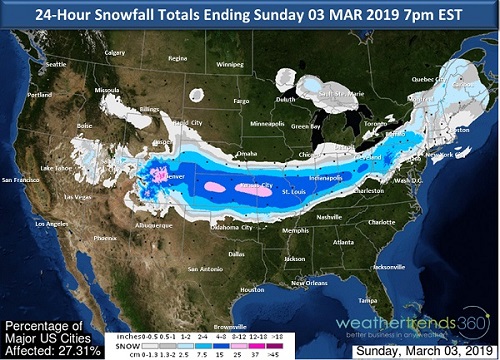
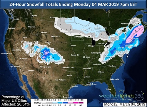
Although meteorological winter ends today, we'll still be dealing with Old Man Winter as we begin March. On Sunday, a storm system will be strengthening across the center of the nation. This storm has the potential to bring moderate to heavy snow anywhere from Colorado and along the I-70 corridor and up into the Northeast. The precipitation begins early Sunday in the Central U.S. and spreads eastward through the day reaching the East by the evening. The storm will wrap-up in New England during the day on Monday. Although details are sure to change between now and Sunday, there is the potential for this to be one of the heaviest falls of snow so far this season for parts of the Northeast, especially for the area just west of the I-95 corridor. The line dividing rain and snow will be a deciding factor as to who sees how much snow near and to the east of I-95, currently areas west of I-95 have the best chance of seeing a plowable accumulating snow, but this could change.


Over the next several days, expect an increase in demand for storm staples like milk, bread, and eggs in the following locations:
- Wichita, KS
- Kansas City, MO
- St. Louis, MO
- Indianapolis, IN
- Louisville, KY
- Cincinnati, OH
- Columbus, OH
- Morgantown, WV
- Pittsburgh, PA
- Harrisburg, PA
- Philadelphia, PA
- New York City, NY
- Albany, NY
- Hartford, CT
- Providence, RI
- Boston, MA
- Springfield, MA
- Manchester, NH
- Portland, ME
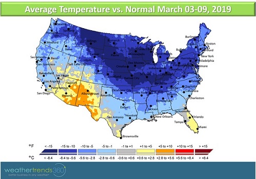
Behind this storm very cold, Arctic air will dump in across the central and eastern U.S. bringing widespread temperatures that are at least -15F below normal for the first week of March. Freezing temperatures could dip as far down as the Deep South which poses a risk to sensitive vegetation. The first week of March is forecast to be one of the coldest of the past 30 years for the U.S. as a whole. Temperatures should moderate by the second week of March.
