Captain's Log 7 Nov '21 November Much Better for Retailers
Captain's Log
Tuesday 9 November Snow Update:
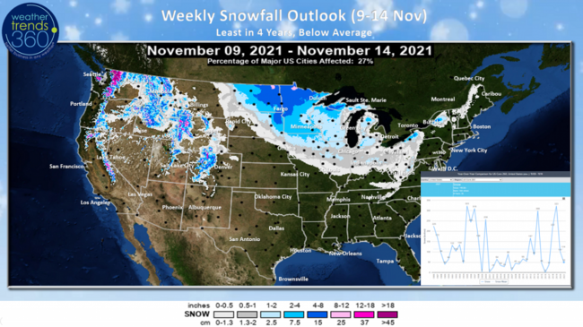
A light to moderate snow event will bring the season's first accumulating snowfall to the Upper Plains. Eastern North Dakota to Northern Minnesota will get 4-8" with a few pockets over 8" near the Canadian Border. Despite this system, the weekly snowfall is still trending the least in 4 years and well below average for the 9-14 November period.
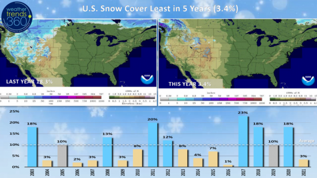
Snow Cover this morning across the U.S. was only 3.4% which is the compared to 18% this time last year and 10% average.
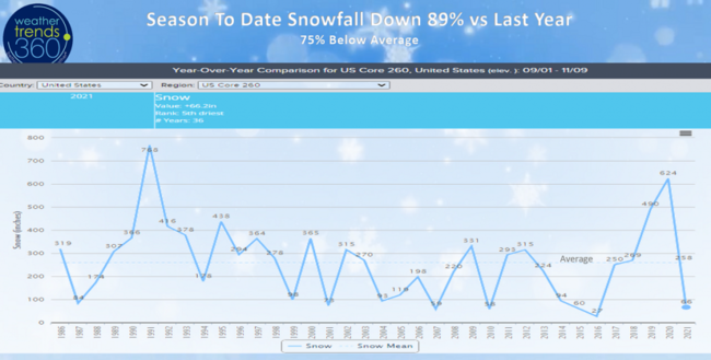
Season-to-date snowfall has made a wholesale change from last year when the U.S. got off to the snowiest start in 29 years, slowest start in 5 years this year with 89% less snowfall than last year and 75% below average. This will likely change in December and January which look to be much snowier months ahead!
Happy Sunday (7 November)! :)
If you're afraid of heights, don't watch the first few minutes of today's video. TOP SECRET why we were on top of wt360 HQ this past week - more to come. :) CLICK ON IMAGES FOR A LARGER VIEW.
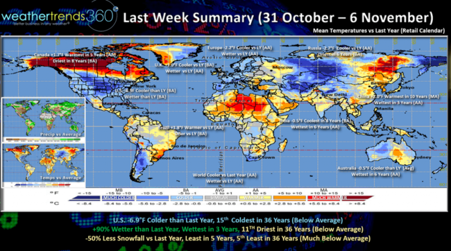
The World roundup for last week (31 Oct - 6 Nov) shows a very strong week for Fall seasonal merchandise sales with the U.S. trending -6.9F colder than last year, 15th coldest in 36 years with below average national temperatures! The first time the U.S. has trended below average nationally since early August (13 weeks ago). Rainfall was up +90% over last year, wettest in 3 years but still 11th driest of the past 36 years and below average nationally. U.S. snowfall was again down 50% vs last year, least in 5 years and 5th least in 36 years so much below average for the 260 city snowfall index.
The other more favorable spots for Fall merchandise were in the U.K., Europe, Russia that also trended cooler. Canada continued to trend warmest in 5 years.
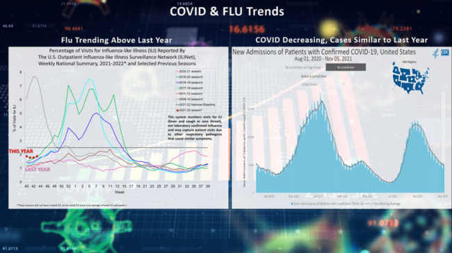
While FLU is trending a bit higher than last year, there's hope for another weak FLU season with Australia as an indicator. Down Under had their second year in a row with historically low FLU conditions, let's hope that's the case for the U.S. Right now it appears a more traditional FLU peak in late January or early February with much colder and snowier conditions like to help in the spread this year vs the near record warmth last year. COVID cases continue their decline with a case load similar to this time last year per the CDC.
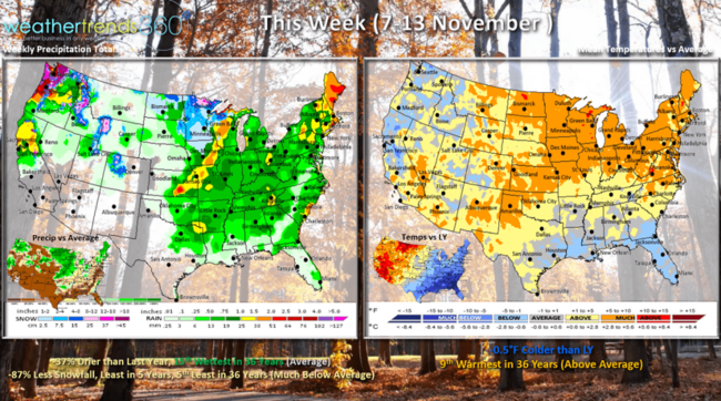
This week (7-13 Nov) shows the U.S. continuing to trend -0.5F cooler than last year but now 9th warmest in 36 years with above average national temperatures. The most favorable spots for Fall seasonal sales would be in the Deep South. Rainfall down 37% vs last year but 15th wettest of the past 36 years, near average nationally. Snow will continue to fall in the Rocky Mountains and the season's first in the Upper Plains, but still 87% less than last year, least in 5 years and 5th least in 36 years so not a lot by early November standards.
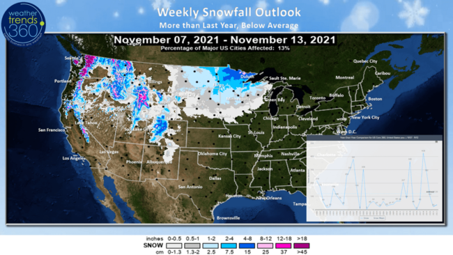
The 6-day snowfall tally does show the heavier mountain snow and accumulating snow in Minnesota.
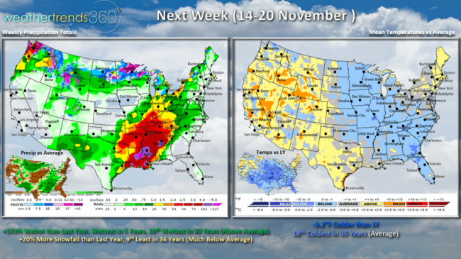
Next week (14-20 Nov) a bit more favorable for seasonal sales with U.S. temperatures trending 3.2F cooler than last year, 18th coldest of the past 36 years with near average U.S. temperatures. All but the West and New England trend colder than a year ago. Rainfall way up +173% over last year, wettest in 5 years and 10th wettest of the past 36 years with heavier rain in the South Central U.S. Snowfall up 20% over last year but still 9th least in 36 years and much below average. Snowy spots remain the Northwest and Upper Plains.
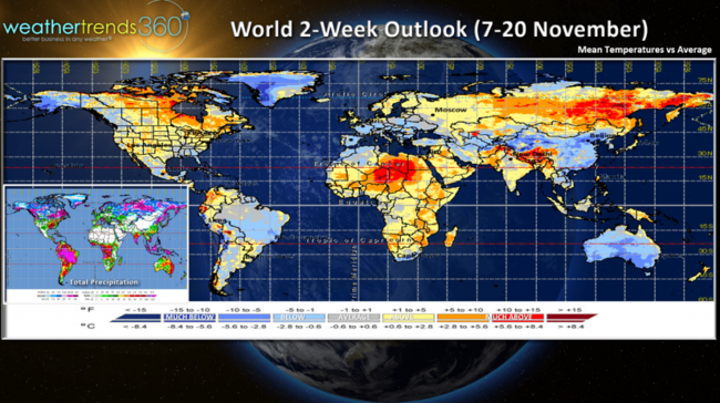
The 2-week World aggregate outlook (7-20 Nov) shows generally above average temperatures across North America, cooler across Europe and China.
We hope you have a great week, and don't forget to follow us on social media for frequent updates: Facebook, Twitter, YouTube, Pinterest and Linkedin
- Captain Kirk out
A light to moderate snow event will bring the season's first accumulating snowfall to the Upper Plains. Eastern North Dakota to Northern Minnesota will get 4-8" with a few pockets over 8" near the Canadian Border. Despite this system, the weekly snowfall is still trending the least in 4 years and well below average for the 9-14 November period.

Snow Cover this morning across the U.S. was only 3.4% which is the compared to 18% this time last year and 10% average.

Season-to-date snowfall has made a wholesale change from last year when the U.S. got off to the snowiest start in 29 years, slowest start in 5 years this year with 89% less snowfall than last year and 75% below average. This will likely change in December and January which look to be much snowier months ahead!

Happy Sunday (7 November)! :)
If you're afraid of heights, don't watch the first few minutes of today's video. TOP SECRET why we were on top of wt360 HQ this past week - more to come. :) CLICK ON IMAGES FOR A LARGER VIEW.

The World roundup for last week (31 Oct - 6 Nov) shows a very strong week for Fall seasonal merchandise sales with the U.S. trending -6.9F colder than last year, 15th coldest in 36 years with below average national temperatures! The first time the U.S. has trended below average nationally since early August (13 weeks ago). Rainfall was up +90% over last year, wettest in 3 years but still 11th driest of the past 36 years and below average nationally. U.S. snowfall was again down 50% vs last year, least in 5 years and 5th least in 36 years so much below average for the 260 city snowfall index.
The other more favorable spots for Fall merchandise were in the U.K., Europe, Russia that also trended cooler. Canada continued to trend warmest in 5 years.

While FLU is trending a bit higher than last year, there's hope for another weak FLU season with Australia as an indicator. Down Under had their second year in a row with historically low FLU conditions, let's hope that's the case for the U.S. Right now it appears a more traditional FLU peak in late January or early February with much colder and snowier conditions like to help in the spread this year vs the near record warmth last year. COVID cases continue their decline with a case load similar to this time last year per the CDC.

This week (7-13 Nov) shows the U.S. continuing to trend -0.5F cooler than last year but now 9th warmest in 36 years with above average national temperatures. The most favorable spots for Fall seasonal sales would be in the Deep South. Rainfall down 37% vs last year but 15th wettest of the past 36 years, near average nationally. Snow will continue to fall in the Rocky Mountains and the season's first in the Upper Plains, but still 87% less than last year, least in 5 years and 5th least in 36 years so not a lot by early November standards.

The 6-day snowfall tally does show the heavier mountain snow and accumulating snow in Minnesota.

Next week (14-20 Nov) a bit more favorable for seasonal sales with U.S. temperatures trending 3.2F cooler than last year, 18th coldest of the past 36 years with near average U.S. temperatures. All but the West and New England trend colder than a year ago. Rainfall way up +173% over last year, wettest in 5 years and 10th wettest of the past 36 years with heavier rain in the South Central U.S. Snowfall up 20% over last year but still 9th least in 36 years and much below average. Snowy spots remain the Northwest and Upper Plains.

The 2-week World aggregate outlook (7-20 Nov) shows generally above average temperatures across North America, cooler across Europe and China.
We hope you have a great week, and don't forget to follow us on social media for frequent updates: Facebook, Twitter, YouTube, Pinterest and Linkedin
- Captain Kirk out