Captain's Log 6 July 2020 Tropical East, Drought West
Captain's Log
Happy Monday! :)
We hope you had a great Independence Day weekend, hard to believe it's already early July...only 77 days until Fall. CLICK ON IMAGES FOR A LARGER VIEW.
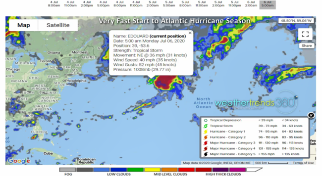
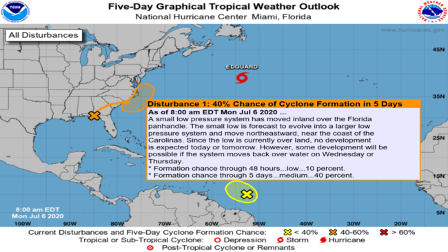
We have tropical system #5 (T.S. Edouard) in the Atlantic continuing the near record early start. The East Coast has some risk for system #6 later this week; it will be called Fay if a system develops.
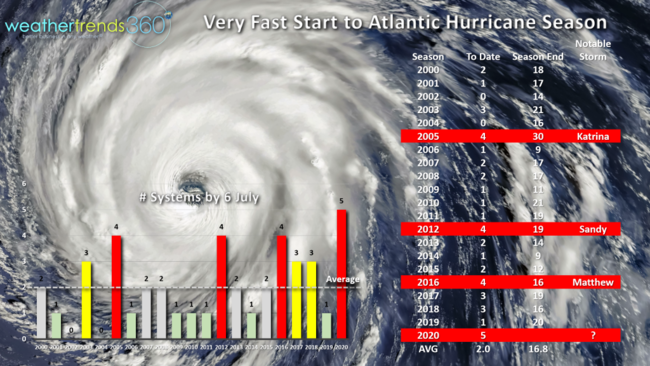
Fast starts typically mean a very active season with a devastating storm more likely. The fast starting seasons in 2005, 2012, 2016 all had major hurricane impacts to the U.S. and we expect the same this year.
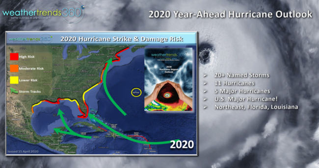
Our year-ahead outlook called for the 2020 season to have 20+ named systems with high threat areas to SE Florida, Central Gulf and New York City area.
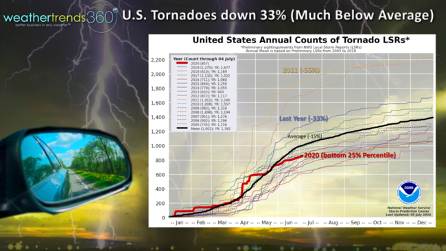
The one thing that is way down is tornadoes, down 33% from last year, 15% below average and 55% down from the very active 2011 season. This makes the season in the bottom 25% percentile as WTI predicted last Fall.
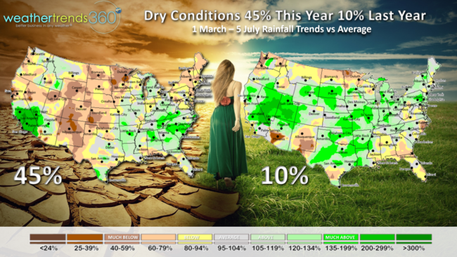
WTI also predicted that dry to drought-like conditions would surge from 8% last year to 50% in 2020 and we're already at 45% of the country in dry to drought like phases. We expect this to go to 54% in early 2021 making it the driest pattern in 8-9 years after some record wet years here in the U.S.
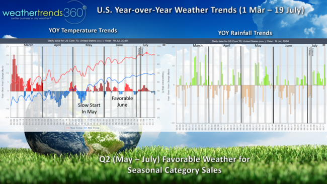
Spring to date year-over-year trends across the U.S. show the very warm March, cool April and early May, but a generally warmer YOY pattern since. Q2 certainly started off slow for seasonal sales in May but June should have been more favorable for household goods, garden, food and beverages and even apparel.
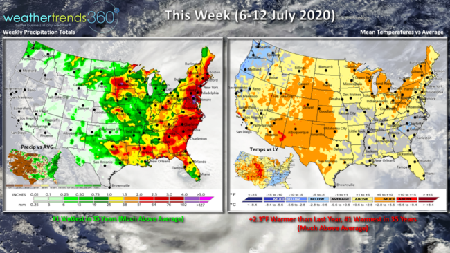
This week (6-12 July) shows the U.S. trending 2.3F warmer than last year making it the #1 hottest in over 35 years for the U.S. overall. Rainfall is way up due to the East Coast tropical threat; national rainfall expected to be the #1 wettest in 35 years. The cool spots are the Pacific Northwest and rain cooled air in the Southeast.
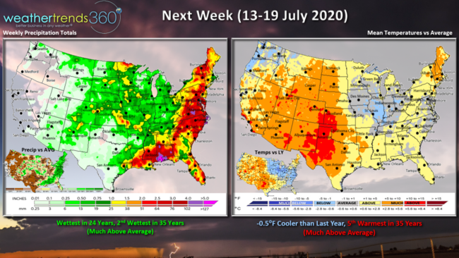
Next week (13-19 July) trends 0.5F cooler than a year ago for the nation as a whole making it 5th warmest in 35 years. A bit cooler in the Midwest with the heart of the heat in the Rocky Mountains and Central U.S. Dry areas tend to get hotter and hotter areas tend to get drier so worsening drought conditions developing in the Plains!
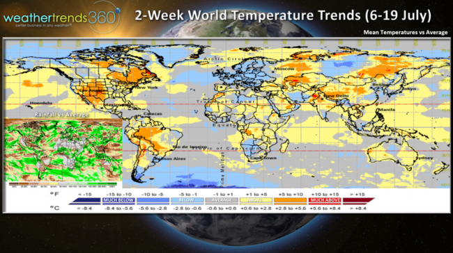
The 2-week world aggregate for the 6-19 July period shows the U.S. h0t/wet, Europe generally cooler/drier, Brazil warm/dry and China warm/wet.
We hope you have a great week ahead and don't forget to follow us on social media for frequent updates: Facebook, Twitter, YouTube, Pinterest and Linkedin
- Captain Kirk out.