Captain's Log 4 May '24 Another Stormy Week
Captain's Log
4 May '24: Happy Saturday :)
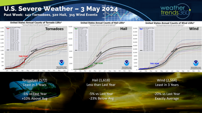
Another severe weather week tornadoes now trending above average YTD, winds at average and hail below average. CLICK ON IMAGES FOR A LARGER VIEW.
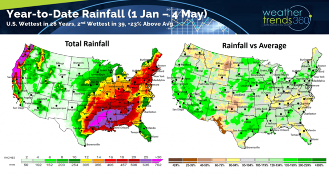
The combination of the decaying El Nino and the massive amount of water vapor from the Tonga volcano a couple years ago continues to make the World and U.S. WET! U.S. rainfall YTD is the most in 26 years, 2nd most in 39 years and +23% above average.
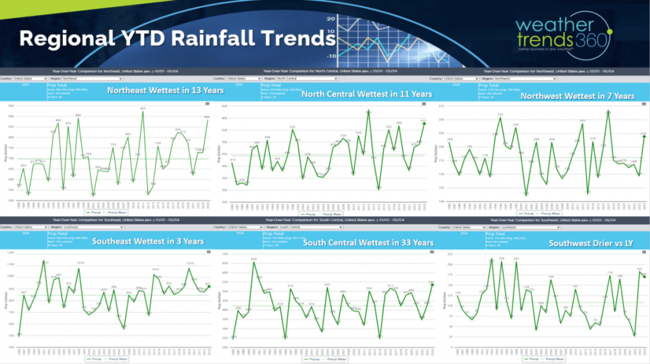
Regional trends show the South Central the wettest in 33 years, Northeast wettest in 13 years, North Central wettest in 11 years, Norwest wettest in 7 years, Southeast wettest in 3 years while the Southwest is drier but still well above average.
We're just 28 days away from the official start of the 2024 hurricane season. All forecasts point to an extremely active season ahead with La Niña reducing wind shear and the Atlantic main development area ocean temps near record warm. wt360 issued our 2024 outlook last Fall calling for 24+ systems and the 3rd most active season in over 170 years. wt360 offers several in-season hurricane reports with your store level impacts and a couple interactive software solutions as well. E-mail support@weathertrends360.com for more information.
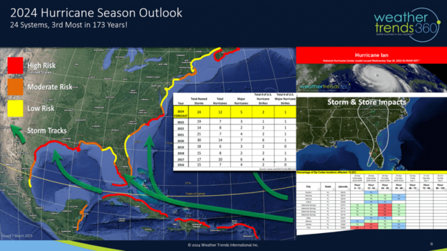
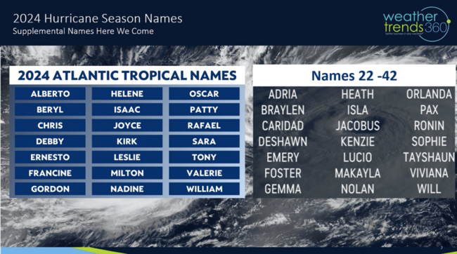
Very likely we use up the 21 names and then go to the supplemental list. Is your name on the list? Our highest risk areas is Texas, South Florida and North Carolina. The Caribbean looks to be hard hit with many Cape Verde systems coming off Africa.
Last week (28 Apr - 4 May) across the World shows the U.S. trending +5.3F warmer than last year, warmest in 3 years and 3rd warmest of the past 39 years. This was a very strong finish to Q1 (Feb - Apr) for retailers and seasonal suppliers that had a bit of slow down in late March and early April. Rainfall was +37% more than LY, most in 7 years and 3rd wettest in 39 years. Rain continues to be a drain on store traffic with on-line doing better in stormy weather.
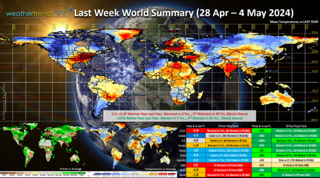
Below average temperatures were in Russia, China and Australia, while it was #1 warmest in India and Brazil.
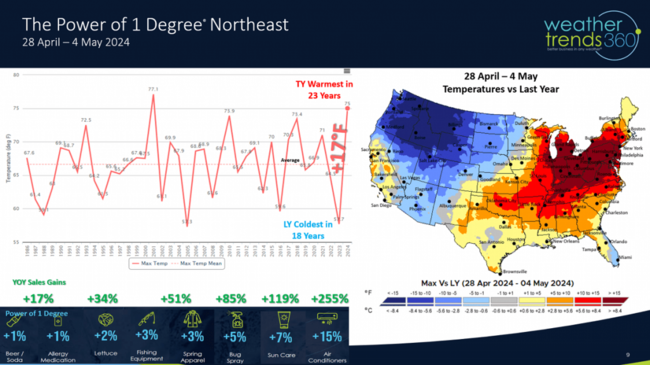
Quantifying the weather lift in seasonal sales for the last week of the retail Q1 showed exceptional trends for the Northeastern U.S. Northeast temperatures were +17F warmer than last year (coldest in 18 years) and the warmest in 23 years. Applying our Power of 1 Degree® technology on sales the lift in many seasonal sales were strong even triple digit sales gains. Unfortunately the weekend weather has been the less favorable part of the week and that trend continues into Mother's Day weekend.
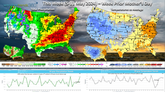
This week (5-11 May) shows the U.S. trending -0.2F cooler than last year but still 9th warmest of the past 39 years. While the East is much warmer a major cooling trend is again likely toward the Mother's Day weekend. It's also +49% wetter nationally, wettest in 5 years and 4th wettest in 39 years which again is a negative on store traffic. More severe weather likely with the active pattern.
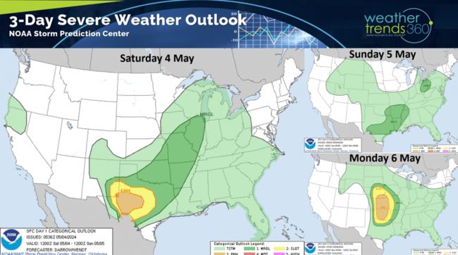
The 3-day NOAA Storm Prediction Center outlook shows severe conditions in Texas today and widespread in the Central Plains by Monday.
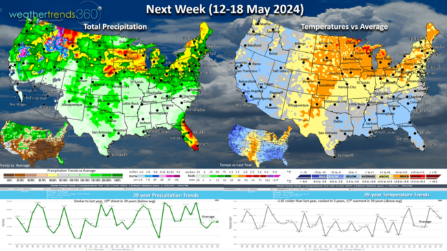
Next week (12-18 May) shows a warm up after the cool weekend in the East, but national temperatures still trend -1.6F cooler than last year, coolest in 3 years but 11th warmest in 39 years. Rainfall flat to last year with the heavier rain shifting to the northern tier of the U.S.
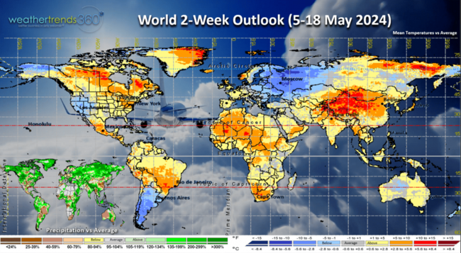
The World 2-week outlook (5-18 May) shows a warmer pattern for Canada and the Eastern U.S. and Western Europe, while the Western U.S., Eastern Europe are generally cooler and less favorable for seasonal sales.
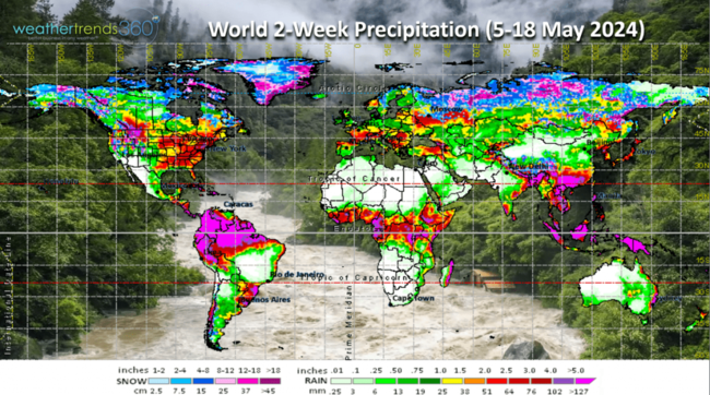
World precipitation shows a continued stormy U.S., very dry Brazil and snowy Russia.
We hope you have a great week ahead and don't forget to follow us on social media for frequent updates: Twitter, YouTube, Pinterest and Linkedin.
Captain Kirk out.
Another severe weather week tornadoes now trending above average YTD, winds at average and hail below average. CLICK ON IMAGES FOR A LARGER VIEW.

The combination of the decaying El Nino and the massive amount of water vapor from the Tonga volcano a couple years ago continues to make the World and U.S. WET! U.S. rainfall YTD is the most in 26 years, 2nd most in 39 years and +23% above average.

Regional trends show the South Central the wettest in 33 years, Northeast wettest in 13 years, North Central wettest in 11 years, Norwest wettest in 7 years, Southeast wettest in 3 years while the Southwest is drier but still well above average.

We're just 28 days away from the official start of the 2024 hurricane season. All forecasts point to an extremely active season ahead with La Niña reducing wind shear and the Atlantic main development area ocean temps near record warm. wt360 issued our 2024 outlook last Fall calling for 24+ systems and the 3rd most active season in over 170 years. wt360 offers several in-season hurricane reports with your store level impacts and a couple interactive software solutions as well. E-mail support@weathertrends360.com for more information.

Very likely we use up the 21 names and then go to the supplemental list. Is your name on the list? Our highest risk areas is Texas, South Florida and North Carolina. The Caribbean looks to be hard hit with many Cape Verde systems coming off Africa.

Last week (28 Apr - 4 May) across the World shows the U.S. trending +5.3F warmer than last year, warmest in 3 years and 3rd warmest of the past 39 years. This was a very strong finish to Q1 (Feb - Apr) for retailers and seasonal suppliers that had a bit of slow down in late March and early April. Rainfall was +37% more than LY, most in 7 years and 3rd wettest in 39 years. Rain continues to be a drain on store traffic with on-line doing better in stormy weather.

Below average temperatures were in Russia, China and Australia, while it was #1 warmest in India and Brazil.

Quantifying the weather lift in seasonal sales for the last week of the retail Q1 showed exceptional trends for the Northeastern U.S. Northeast temperatures were +17F warmer than last year (coldest in 18 years) and the warmest in 23 years. Applying our Power of 1 Degree® technology on sales the lift in many seasonal sales were strong even triple digit sales gains. Unfortunately the weekend weather has been the less favorable part of the week and that trend continues into Mother's Day weekend.

This week (5-11 May) shows the U.S. trending -0.2F cooler than last year but still 9th warmest of the past 39 years. While the East is much warmer a major cooling trend is again likely toward the Mother's Day weekend. It's also +49% wetter nationally, wettest in 5 years and 4th wettest in 39 years which again is a negative on store traffic. More severe weather likely with the active pattern.

The 3-day NOAA Storm Prediction Center outlook shows severe conditions in Texas today and widespread in the Central Plains by Monday.

Next week (12-18 May) shows a warm up after the cool weekend in the East, but national temperatures still trend -1.6F cooler than last year, coolest in 3 years but 11th warmest in 39 years. Rainfall flat to last year with the heavier rain shifting to the northern tier of the U.S.

The World 2-week outlook (5-18 May) shows a warmer pattern for Canada and the Eastern U.S. and Western Europe, while the Western U.S., Eastern Europe are generally cooler and less favorable for seasonal sales.

World precipitation shows a continued stormy U.S., very dry Brazil and snowy Russia.
We hope you have a great week ahead and don't forget to follow us on social media for frequent updates: Twitter, YouTube, Pinterest and Linkedin.
Captain Kirk out.