Captain's Log 4 Mar '23 Snowiest Retail March in 18 Years!
Captain's Log
4 March 2023 Happy Saturday! :)
We've made some major enhancements to our YEAR-AHEAD FarmCast® solution with a page 5 addition on farm specific intel for the entire 2023 season. CLICK ON IMAGES FOR A LARGER VIEW.
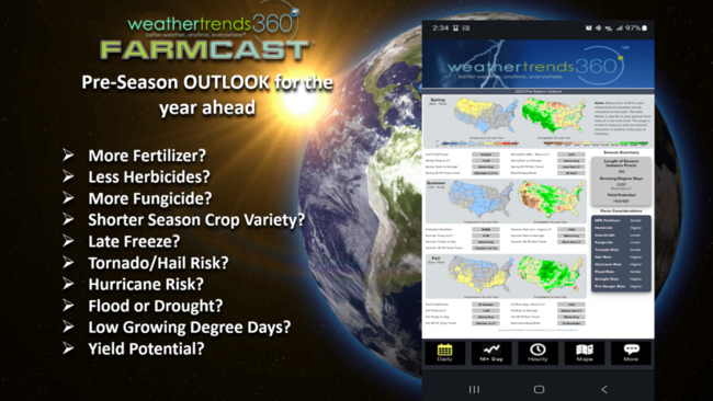 More information on Farmcast: https://www.weathertrends360.com/Agriculture-Weather-Analytics
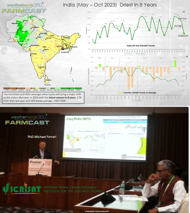
 Our colleague PhD Michael Ferrari presented in India at the International Crops Research Institute for the Semi-Arid Tropics conference sharing our drought outlook for India - driest in 8 years. This will have major implications for in the ground commodities like Sugarcane. Our FarmCast solution is available across India and everywhere on Earth.
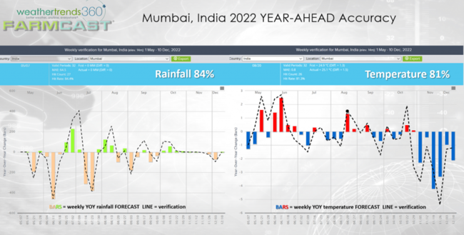
There was a lot of picture taking when Michael pulled up the forecast slides. Our 2022 accuracy for Mumbai India did well trending 81% on year-ahead weekly temperatures and 84% on weekly rainfall.
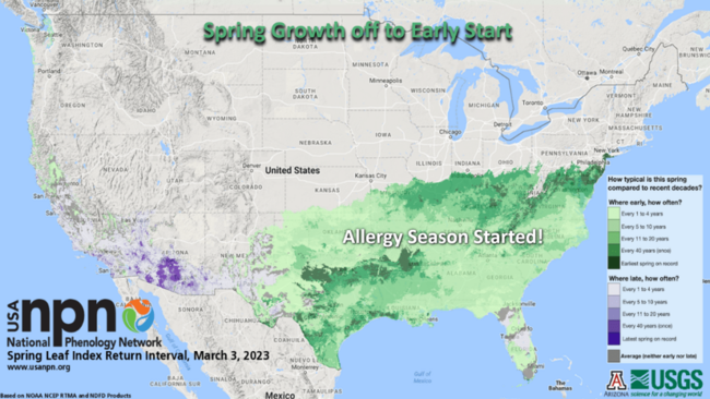
The exceptionally warm Winter in the Southern U.S. has vegetation off to a very fast start from Texas to Southern New Jersey which also means a fast start to the Allergy and Asthma season.
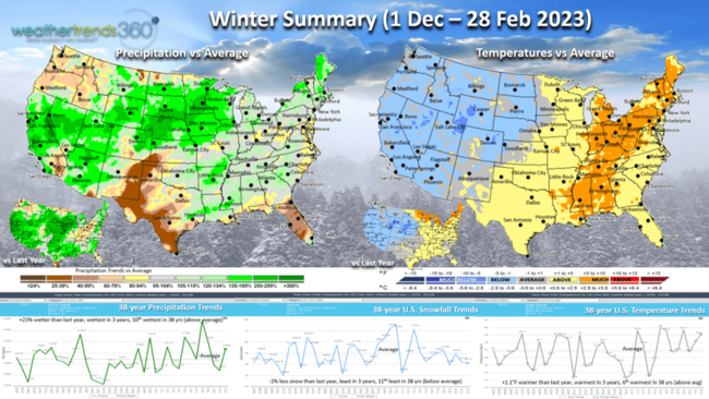
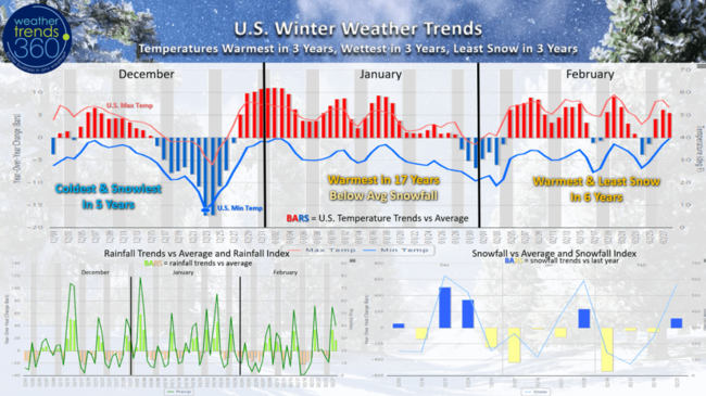
Meteorological Winter (1 Dec - 28 Feb) is in the history books trending the warmest and wettest in 3 years and least snow in 3 years. The major cold snaps were in middle to late December and again late January-early February. December was the coldest and snowiest in 5 years which was a big negative for retailers, especially home centers. The snowiest week of the entire Fall-Winter season remains the week before Christmas.
The milder latter half of Winter was a plus for store traffic and mass merchants with a lot of general merchandise.
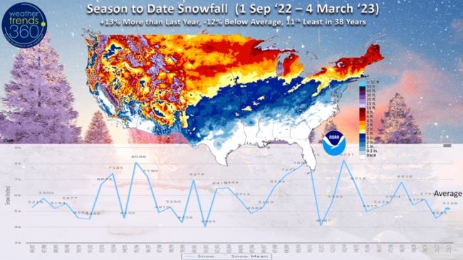
Season to date snowfall is picking up some ground with the snowier pattern setting up. For the 1 Oct to 4 March period snowfall is now +13% more than last year but still -12% below average and 11 least in 38 years nationally.
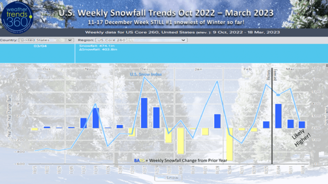
Weekly snowfall trends show the big snowy period in December and now a very snowy late season pattern going into Spring.
Last Week (26 Feb - 4 Mar) around the World shows the U.S. trending +0.9F warmer than last year, warmest in 3 years and 6th warmest of the past 38 years. Rainfall was way up +213% wetter than last year, most in 15 years and 2nd most in 38 years. A strong indicator that the 3-year drought cycle HAS ENDED...get ready for the coldest/wettest year ahead in 4 years! Snowfall was way up with the 3rd snowiest week of Winter, +316% more than last year, most in 5 years and 10th most in 38 years.
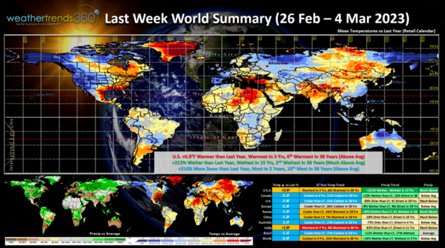
The other cold spots were in Western Europe, Northern Russia, Southern China and Alaska.
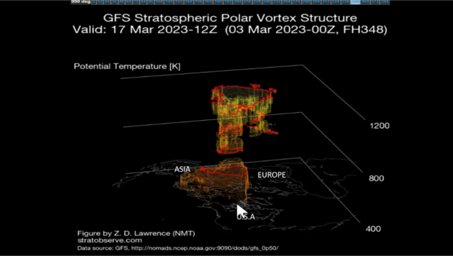
The Polar Vortex remains weak and disorganized and that does allow cold Arctic air to move around the middle latitudes. For now it appears it's going to favor colder conditions in North America - much of the U.S. through at least middle March.
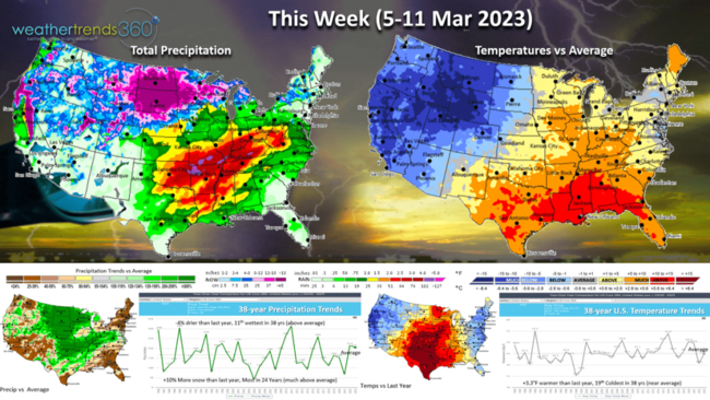
This week (5-11 March) starts off milder in the East before another strong cold front sweeps off the East Coast Tuesday when much of the country will dip to below average. The week overall trends +3.3F warmer than last year and 19th coldest of the past 38 years. Rainfall -4% drier but still 11th wettest of the past 38 years with a very active pattern which will likely include more severe weather and thunderstorms in the South Central U.S. Snowfall will be heavy trending the most in 24 years with a couple bigger events.
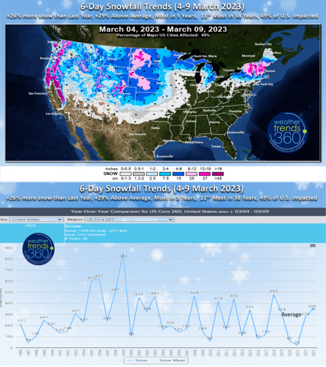
The 6-day snowfall outlook shows 49% of the U.S. having some snow, +26% more than last year, +29% above average, most in 5 years and 11th most of the past 38 years.
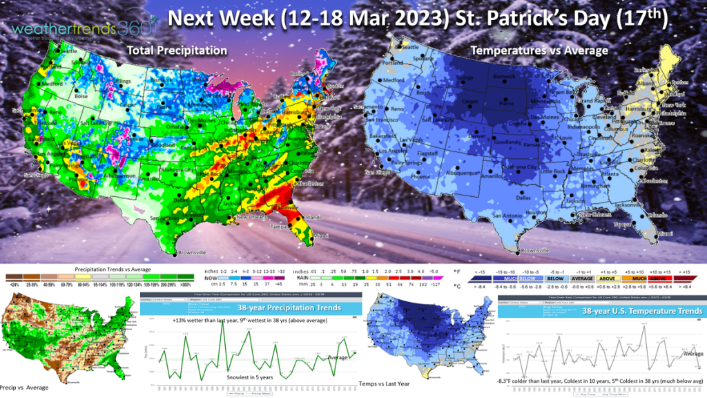 Next week (12-18 March) shows the influence of the weak Polar Vortex with nationwide cold. The U.S. overall looks to trend -8.3F colder than last year, coldest in 10 years and 5th coldest of the past 38 years. This is a big negative for retail and early Spring seasonal sales. Rainfall up +13% and 9th wettest of the past 38 years and snowiest in 5 years. More severe weather likely from Texas to the Southeast. There are a couple big snow storm threats possible this week in the Middle Atlantic Northeast not depicted here - will just depend on the exact track but certainly a favorable pattern for a bigger late Winter snowstorm in the snow deprived coastal Northeast.
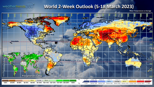
The 2-week World outlook (5-18 March) shows the cold spots in North America, Northern Europe and Northern Russia.
Have a great week and don't forget to follow us on social media for frequent updates: Facebook, Twitter, YouTube, Pinterest and Linkedin.
- Captain Kirk out.