Captain's Log 30 June '24 Cooler, Wetter with Tropical Threat
Captain's Log
30 June '24: Happy Sunday! :)
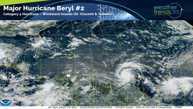
Category 4 Hurricane Beryl is the earliest CAT 4 in the Atlantic Basin history and headed for St. Vincent in the Windward Islands tomorrow, Jamaica midweek and possibly Texas late next weekend. CLICK ON IMAGES FOR A LARGER VIEW.
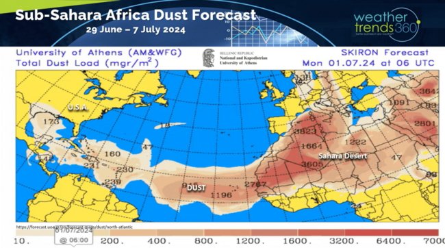
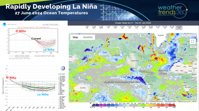
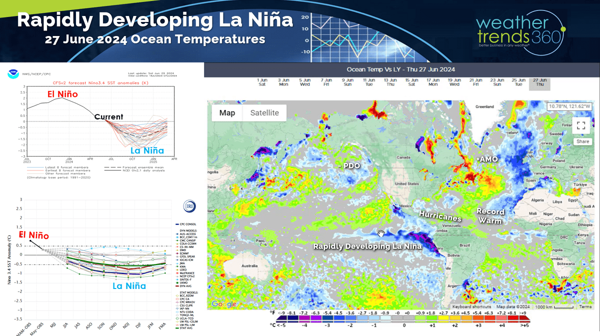
This should be a warning for just how active this season will be as Beryl had to contend with suppressing dust off Africa yet it intensified rapidly due to the very warm ocean temperatures and little wind shear more typical of a La Niña cycle.
This is giving little warning to the Central Windward Islands near St. Vincent and Grenada.
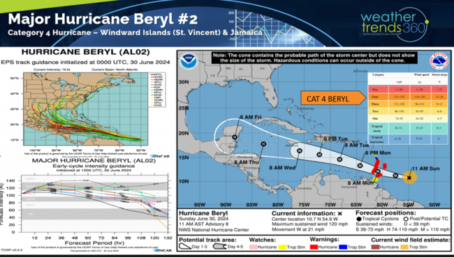
Beryl will track steadily toward the Western Gulf of Mexico with a possible threat to the U.S. Texas Coast around Monday 8 July. Track this far out very much subject to change but these Deep South tracks favor the Western Gulf of Mexico for landfall.
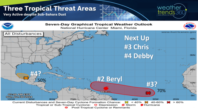
There are two other threat areas with the system behind Beryl having the best chance to become the next Tropical Storm (#3 Chris) with a similar track as Beryl.
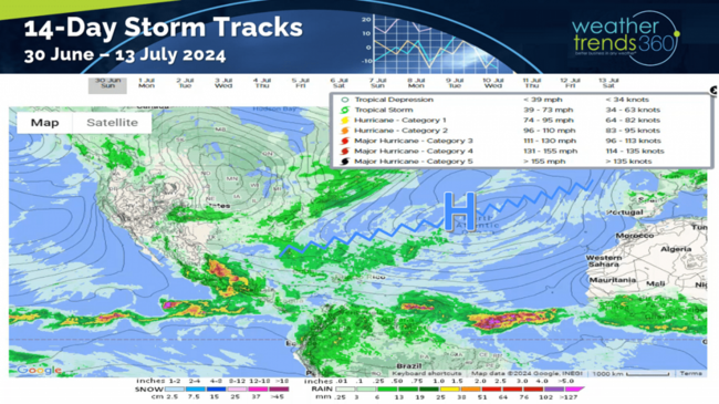
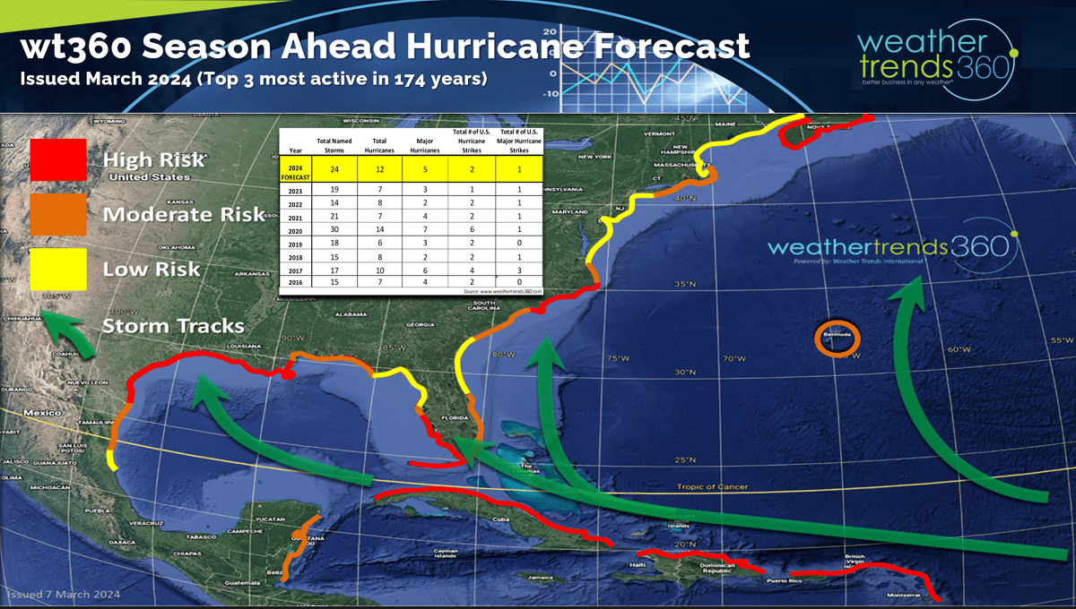
The Bermuda high in the Central Atlantic is strong and allowing for this deeper Caribbean track which WTI warned about with our pre-season Hurricane outlook issued in March.
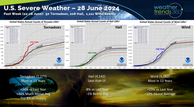
Severe weather continued to be active in the Continental U.S. with 50 more tornadoes, 208 hail events and a very significant 1,111 wind events. Season-t0-date is the most active in 13 years and in the top 8% of history for tornadoes. WTI warned about this late last Fall with our 2024 Insurance Risk Outlook with the 3rd most active hurricane season just getting started.

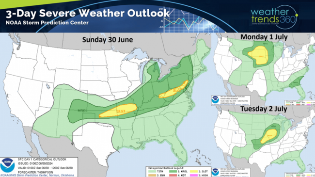
The next 3-days remain active with a series of cool fronts triggering more activity in the Midwest and East.
One reason for all the severe weather is the climate cycle shift to a La Niña pattern as the Equatorial Pacific Ocean continues to cool rapidly. La Niña reduces wind shear allowing storms to develop and combined with the trillions of gallons of excess water vapor from the 2022 Tonga Volcano we have several ingredients necessary for a catastrophic 2024 season for weather disasters.
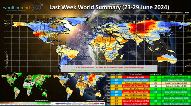
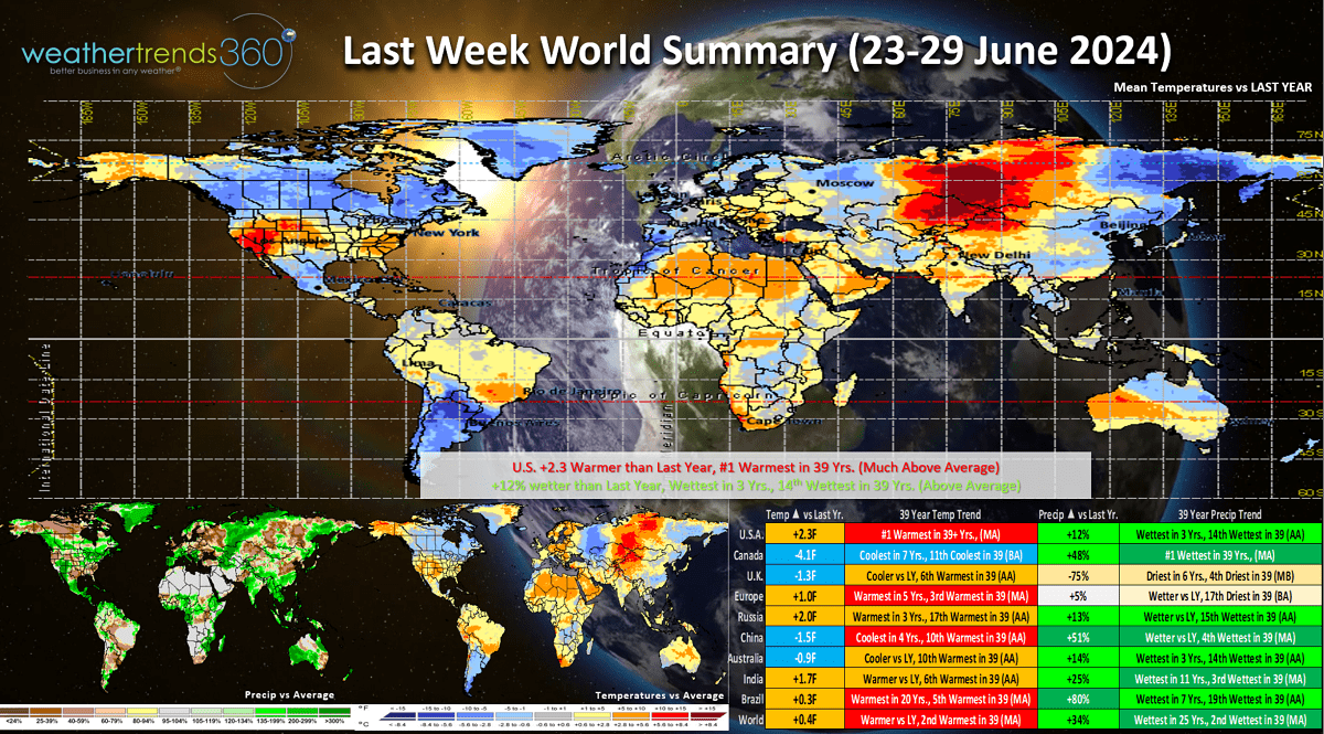
Last week (23-29 June) across the World shows the U.S. trending +2.3F warmer than last year and #1 warmest in 39 years despite a cooling trend for the northern tier of the U.S. Rainfall was up +12% vs a year ago, wettest in 3 years and 14th wettest of the past 39 years. The West and Southeast were the hottest spots and most favorable for stronger seasonal sales gains, especially for consumables like cold beverages, vegetables and AC demand and service. The coolest conditions in 7 years with below normal temperatures across Canada while Europe warmed up.
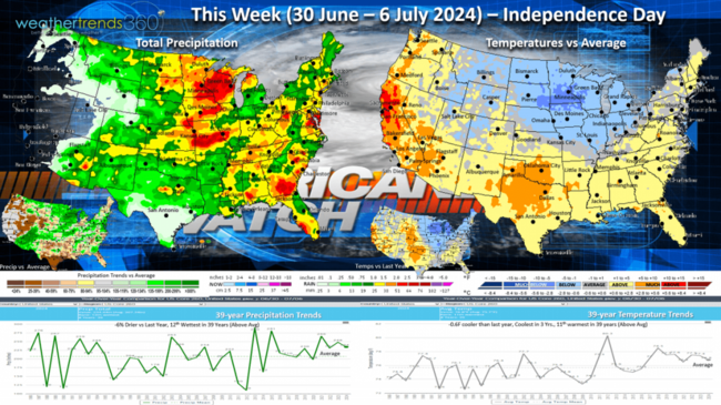
This week (30 June - 6 July) shows a continued cooler pattern for the Midwest and Great Lakes with the heat expanding along the West Coast and Texas. The U.S. overall trends -0.6F cooler than last year, coolest in 3 years and 11th warmest of the past 39 years. While rainfall is down -6% vs last year, it's still the 12th wettest of the past 39 years with heavy rains for the parched Southwest and in the flood raged Midwest. All eyes on the tropics late in the week for a possible threat to the U.S. Texas coast.
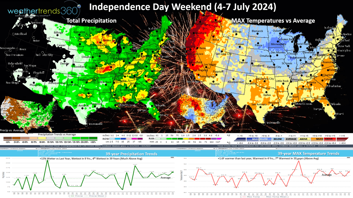
The Independence Day 4th of July weekend (4-7 July) shows the very cool conditions in the Midwest, Great Lakes while the West Coast bakes! The weekend overall trends +1.6F warmer than last year, warmest in 4 years and 7th warmest of the past 39 for the U.S. overall. It's stormy with rainfall up +13% vs last year, wettest in 9 years and 4th wettest of the past 39 years. The Eastern half of the country will have a lot of thunderstorms to dodge!

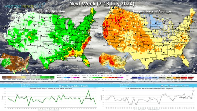
Next week (7-13 July) shows the heat building in the West and South Central Plains with cool weather lingering in the Upper Midwest. The U.S. overall trends +3.4F warmer than last year and #1 warmest of the past 39 years. Rainfall -50% drier than last year and 3rd driest in 39 years. These conditions will continue to favorable consumable seasonal categories like cold beverages, pool chemicals and AC but at the expense of overall store traffic as consumers flock to lakes, beaches and pools. Still need to watch the U.S. Coast for tropical threats.
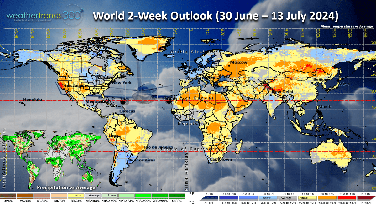
The 2-week (30 June - 13 July) World outlook shows the U.S. West the hot spot while the UK and Central Europe are relatively cool.
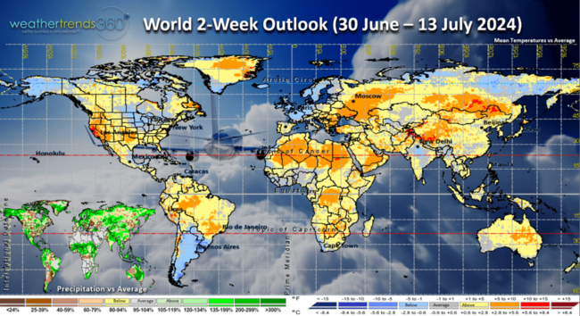
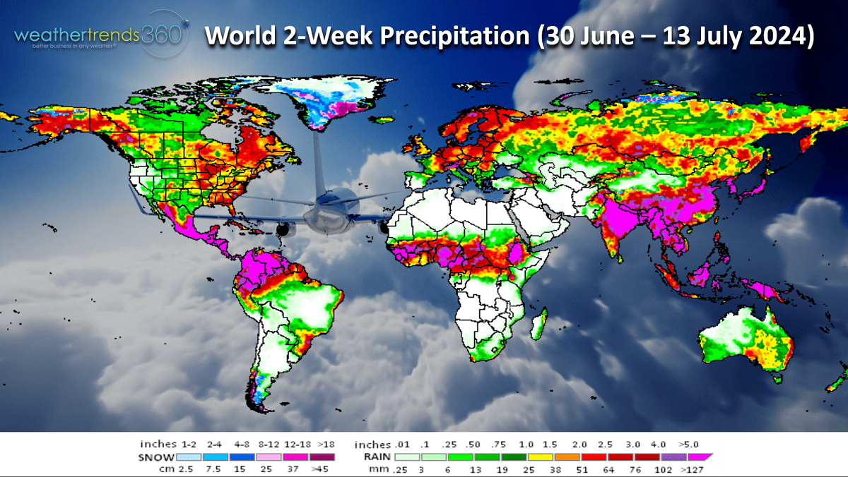
World rainfall shows ample rainfall in the U.S. Corn Belt allowing prices to plummet below $4. Drought in Mexico is being erased with the active tropical pattern.

Have a great week ahead and don't forget to follow us on social media for frequent updates: Facebook, Twitter, YouTube, Pinterest and Linkedin.
- Captain Kirk out.
Category 4 Hurricane Beryl is the earliest CAT 4 in the Atlantic Basin history and headed for St. Vincent in the Windward Islands tomorrow, Jamaica midweek and possibly Texas late next weekend. CLICK ON IMAGES FOR A LARGER VIEW.

This should be a warning for just how active this season will be as Beryl had to contend with suppressing dust off Africa yet it intensified rapidly due to the very warm ocean temperatures and little wind shear more typical of a La Niña cycle.

This is giving little warning to the Central Windward Islands near St. Vincent and Grenada.

Beryl will track steadily toward the Western Gulf of Mexico with a possible threat to the U.S. Texas Coast around Monday 8 July. Track this far out very much subject to change but these Deep South tracks favor the Western Gulf of Mexico for landfall.

There are two other threat areas with the system behind Beryl having the best chance to become the next Tropical Storm (#3 Chris) with a similar track as Beryl.

The Bermuda high in the Central Atlantic is strong and allowing for this deeper Caribbean track which WTI warned about with our pre-season Hurricane outlook issued in March.

Severe weather continued to be active in the Continental U.S. with 50 more tornadoes, 208 hail events and a very significant 1,111 wind events. Season-t0-date is the most active in 13 years and in the top 8% of history for tornadoes. WTI warned about this late last Fall with our 2024 Insurance Risk Outlook with the 3rd most active hurricane season just getting started.
The next 3-days remain active with a series of cool fronts triggering more activity in the Midwest and East.

One reason for all the severe weather is the climate cycle shift to a La Niña pattern as the Equatorial Pacific Ocean continues to cool rapidly. La Niña reduces wind shear allowing storms to develop and combined with the trillions of gallons of excess water vapor from the 2022 Tonga Volcano we have several ingredients necessary for a catastrophic 2024 season for weather disasters.
Last week (23-29 June) across the World shows the U.S. trending +2.3F warmer than last year and #1 warmest in 39 years despite a cooling trend for the northern tier of the U.S. Rainfall was up +12% vs a year ago, wettest in 3 years and 14th wettest of the past 39 years. The West and Southeast were the hottest spots and most favorable for stronger seasonal sales gains, especially for consumables like cold beverages, vegetables and AC demand and service. The coolest conditions in 7 years with below normal temperatures across Canada while Europe warmed up.
This week (30 June - 6 July) shows a continued cooler pattern for the Midwest and Great Lakes with the heat expanding along the West Coast and Texas. The U.S. overall trends -0.6F cooler than last year, coolest in 3 years and 11th warmest of the past 39 years. While rainfall is down -6% vs last year, it's still the 12th wettest of the past 39 years with heavy rains for the parched Southwest and in the flood raged Midwest. All eyes on the tropics late in the week for a possible threat to the U.S. Texas coast.

The Independence Day 4th of July weekend (4-7 July) shows the very cool conditions in the Midwest, Great Lakes while the West Coast bakes! The weekend overall trends +1.6F warmer than last year, warmest in 4 years and 7th warmest of the past 39 for the U.S. overall. It's stormy with rainfall up +13% vs last year, wettest in 9 years and 4th wettest of the past 39 years. The Eastern half of the country will have a lot of thunderstorms to dodge!
Next week (7-13 July) shows the heat building in the West and South Central Plains with cool weather lingering in the Upper Midwest. The U.S. overall trends +3.4F warmer than last year and #1 warmest of the past 39 years. Rainfall -50% drier than last year and 3rd driest in 39 years. These conditions will continue to favorable consumable seasonal categories like cold beverages, pool chemicals and AC but at the expense of overall store traffic as consumers flock to lakes, beaches and pools. Still need to watch the U.S. Coast for tropical threats.

The 2-week (30 June - 13 July) World outlook shows the U.S. West the hot spot while the UK and Central Europe are relatively cool.
World rainfall shows ample rainfall in the U.S. Corn Belt allowing prices to plummet below $4. Drought in Mexico is being erased with the active tropical pattern.
Have a great week ahead and don't forget to follow us on social media for frequent updates: Facebook, Twitter, YouTube, Pinterest and Linkedin.
- Captain Kirk out.