Captain's Log 30 Dec '23 Polar Vortex on the Move!
Captain's Log
30 Dec 2023: Happy last Saturday in 2023! :)
We hope you had a wonderful Christmas season despite the much warmer conditions than last year. The Kirk family headed south to the Bahamas where it was the coldest in 40+ years...but middle to upper 70s certainly tolerable. CLICK ON IMAGES FOR A LARGER VIEW.

Always fun to see how "humans" react to weather as the local Bahamians were freezing, while the Canadians thought it was very warm. For us, not too bad and when you're 7 even cool'ish water is warm especially if a dolphin wants to dance with you. :)
Don't forget to check out the wt360.com YEAR-AHEAD vacation planner to pick your ideal weather anywhere in the world. It will give you the best 3 weeks for your vacation if you have flexibility on when you travel.
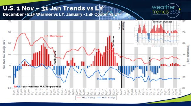
While the Bahamas were cool, the rest of the U.S. had a wholesale change from last year with much milder and less snowy conditions. A plus for store traffic, but a huge negative for Winter seasonal merchandise sales. December trended +6.4F warmer than a year ago so our Power of 1 Degree technology would suggest a -19% decrease in Winter apparel sales but a +6% to +10% increase in store traffic benefiting non-seasonal items. January looks to trend at least -2.4F colder than last year, so some clearance opportunity for seasonal items.
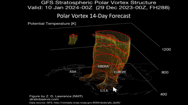
The good news is the strong and symmetrical Polar Vortex looks to weaken and become a bit more ragged with an intrusion into the U.S. by early to middle January. We'll see if it's just a glancing shot or a sign of a pattern shift.
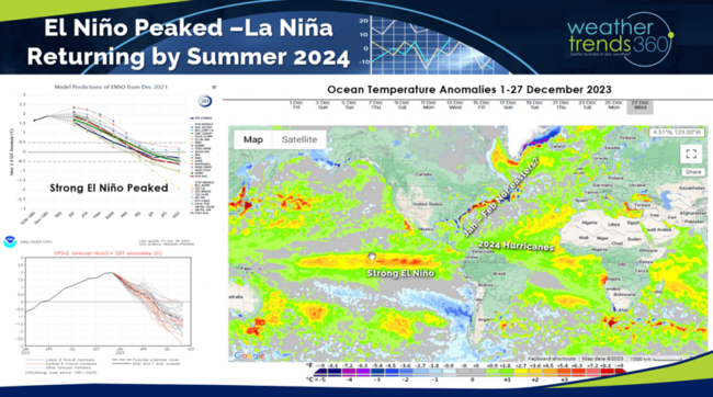
One thing is certain, the El Niño has peaked and now all indication suggests a rapid plunge back to La Niña in 2024. This volatile cycle shift will have major implications on 2024 weather which looks to be extreme!
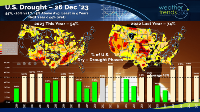
December was very dry in the West, polar opposite last year when California had near historic snowfall, not this year. El Niño has brought some above average rainfall to the Central U.S. and East Coast where it was excessively wet with a few Nor'easter-like WET storms. This pattern suggests a big snowstorm on the East Coast is very likely this Winter - January and especially February. U.S. drought continues to improve with 54% of the U.S. in dry to drought phases, least coverage in 4 years and way down from 74% last year. Drought coverage will be under 40% by Spring.
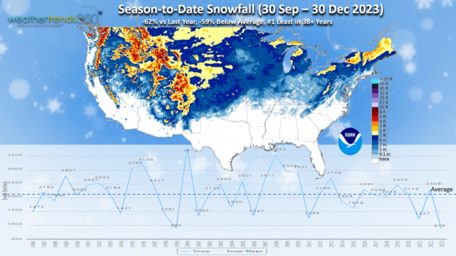
Season-to-date snowfall is way down as expected with -62% less snow than last year, -59% below average and #1 least in 38+ years. This will reverse for the back half of Winter.
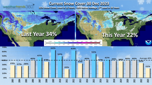
Snow Cover this morning only has 22% of the U.S. covered in some snow, down from 34% last year, 18% below average and the least in 12 years, 2nd least in 20 years.
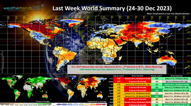
Last week (24-30 Dec) across the World shows the U.S. trending +4.6F warmer than a year ago, warmest in 26 years and 2nd warmest of the past 38 years. Rainfall was +50% more than last year, wettest in 3 years and 7th wettest of the past 38 years while snowfall was -23% vs last year, least in 31 years and 2nd least in 38 years. These were very unfavorable trends for seasonal merchandise sales. Canada was coast to coast warm with even more extreme trends and #1 warmest of the past 38 years.
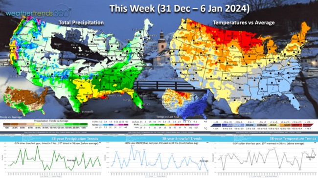
This week (31 Dec - 6 Jan) shows a somewhat typical El Nino weather scenario with a cool Southeast and warm Northern tier. For the U.S. overall, the week trends -5.9F cooler than last year and 15th warmest of the past 39 years. Snowfall -83% less than last year and #1 least in 39 years while rainfall is also -52% drier, driest in 3 years and 12th driest of the past 39 years. These are improved trends for some demand for Winter merchandise, but not snow accessories.
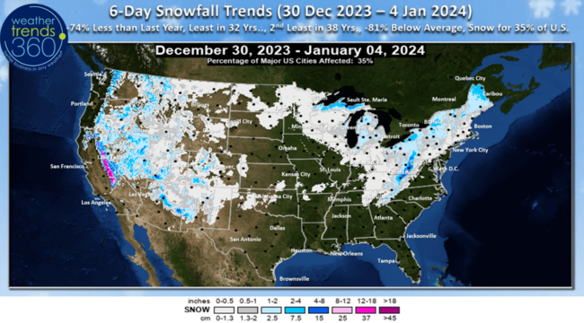
The 6-day snowfall outlook doesn't show much with -75% less than last year, least in 32 years, 2nd least in 39 years and -81% below average. About 35% of the U.S. will have some light snow. The Sierras of California should finally get some much-needed snow after trending over 80% less than a year ago.
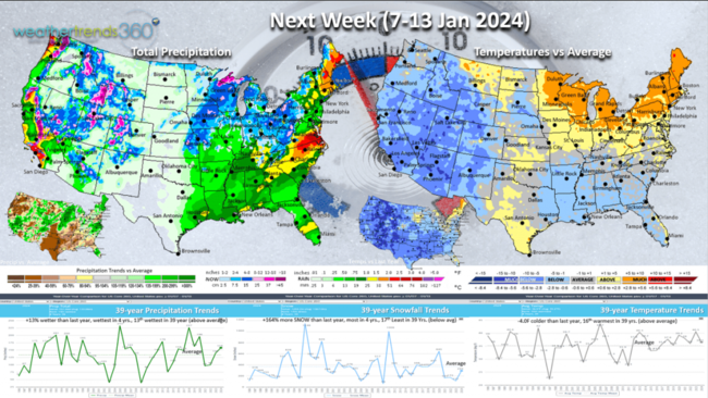
Next week (7-13 Jan) shows signs of the Polar Vortex making a brief incursion into the U.S. While the Northeast starts off milder ahead of this cold front, the latter half of the week turns much colder in the East. For the U.S. overall the week trends -4F colder than last year but still 16th warmest of the past 39 years. Snowfall up +164% over last year, most in 4 years and 17th least of the past 39, with rainfall also up +13%, wettest in 4 years and 13th wettest of the past 39 years. These are improved trends for seasonal merchandise sales.
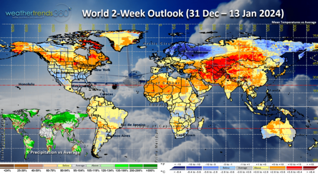
The World 2-week (31 Dec - 13 Jan) outlook is a little misleading in North America as there will be a couple strong cold fronts with brief big warmups ahead of the front followed by much colder weather. Norther Europe clearly the cold spot overall.
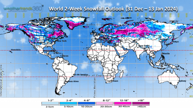
World snowfall shows the heaviest snow likely in Eastern Canada and much of Russia-Siberia.
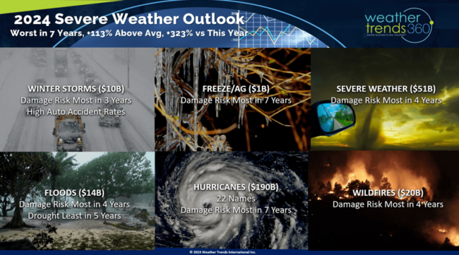
With the rapidly evolving climate cycles and the Equatorial Pacific turning much cooler, the risk for major weather events is very high. Weather Trends is projecting one of the worst severe weather seasons in terms of billion-dollar disasters in 7 years. Very concerned about Texas and South Florida this hurricane season. We have some powerful severe weather tools in partnership with Seek Insights that can help you quantify and forecast how severe weather is helping or hurting your sales across every store.
We hope you have a great end to 2023 and start to 2024. Don't forget to follow us on social media for frequent updates: Facebook, Twitter, YouTube, Pinterest and Linkedin.
- Captain Kirk out
We hope you had a wonderful Christmas season despite the much warmer conditions than last year. The Kirk family headed south to the Bahamas where it was the coldest in 40+ years...but middle to upper 70s certainly tolerable. CLICK ON IMAGES FOR A LARGER VIEW.

Always fun to see how "humans" react to weather as the local Bahamians were freezing, while the Canadians thought it was very warm. For us, not too bad and when you're 7 even cool'ish water is warm especially if a dolphin wants to dance with you. :)
Don't forget to check out the wt360.com YEAR-AHEAD vacation planner to pick your ideal weather anywhere in the world. It will give you the best 3 weeks for your vacation if you have flexibility on when you travel.

While the Bahamas were cool, the rest of the U.S. had a wholesale change from last year with much milder and less snowy conditions. A plus for store traffic, but a huge negative for Winter seasonal merchandise sales. December trended +6.4F warmer than a year ago so our Power of 1 Degree technology would suggest a -19% decrease in Winter apparel sales but a +6% to +10% increase in store traffic benefiting non-seasonal items. January looks to trend at least -2.4F colder than last year, so some clearance opportunity for seasonal items.

The good news is the strong and symmetrical Polar Vortex looks to weaken and become a bit more ragged with an intrusion into the U.S. by early to middle January. We'll see if it's just a glancing shot or a sign of a pattern shift.

One thing is certain, the El Niño has peaked and now all indication suggests a rapid plunge back to La Niña in 2024. This volatile cycle shift will have major implications on 2024 weather which looks to be extreme!

December was very dry in the West, polar opposite last year when California had near historic snowfall, not this year. El Niño has brought some above average rainfall to the Central U.S. and East Coast where it was excessively wet with a few Nor'easter-like WET storms. This pattern suggests a big snowstorm on the East Coast is very likely this Winter - January and especially February. U.S. drought continues to improve with 54% of the U.S. in dry to drought phases, least coverage in 4 years and way down from 74% last year. Drought coverage will be under 40% by Spring.

Season-to-date snowfall is way down as expected with -62% less snow than last year, -59% below average and #1 least in 38+ years. This will reverse for the back half of Winter.

Snow Cover this morning only has 22% of the U.S. covered in some snow, down from 34% last year, 18% below average and the least in 12 years, 2nd least in 20 years.

Last week (24-30 Dec) across the World shows the U.S. trending +4.6F warmer than a year ago, warmest in 26 years and 2nd warmest of the past 38 years. Rainfall was +50% more than last year, wettest in 3 years and 7th wettest of the past 38 years while snowfall was -23% vs last year, least in 31 years and 2nd least in 38 years. These were very unfavorable trends for seasonal merchandise sales. Canada was coast to coast warm with even more extreme trends and #1 warmest of the past 38 years.

This week (31 Dec - 6 Jan) shows a somewhat typical El Nino weather scenario with a cool Southeast and warm Northern tier. For the U.S. overall, the week trends -5.9F cooler than last year and 15th warmest of the past 39 years. Snowfall -83% less than last year and #1 least in 39 years while rainfall is also -52% drier, driest in 3 years and 12th driest of the past 39 years. These are improved trends for some demand for Winter merchandise, but not snow accessories.

The 6-day snowfall outlook doesn't show much with -75% less than last year, least in 32 years, 2nd least in 39 years and -81% below average. About 35% of the U.S. will have some light snow. The Sierras of California should finally get some much-needed snow after trending over 80% less than a year ago.

Next week (7-13 Jan) shows signs of the Polar Vortex making a brief incursion into the U.S. While the Northeast starts off milder ahead of this cold front, the latter half of the week turns much colder in the East. For the U.S. overall the week trends -4F colder than last year but still 16th warmest of the past 39 years. Snowfall up +164% over last year, most in 4 years and 17th least of the past 39, with rainfall also up +13%, wettest in 4 years and 13th wettest of the past 39 years. These are improved trends for seasonal merchandise sales.

The World 2-week (31 Dec - 13 Jan) outlook is a little misleading in North America as there will be a couple strong cold fronts with brief big warmups ahead of the front followed by much colder weather. Norther Europe clearly the cold spot overall.

World snowfall shows the heaviest snow likely in Eastern Canada and much of Russia-Siberia.

With the rapidly evolving climate cycles and the Equatorial Pacific turning much cooler, the risk for major weather events is very high. Weather Trends is projecting one of the worst severe weather seasons in terms of billion-dollar disasters in 7 years. Very concerned about Texas and South Florida this hurricane season. We have some powerful severe weather tools in partnership with Seek Insights that can help you quantify and forecast how severe weather is helping or hurting your sales across every store.
We hope you have a great end to 2023 and start to 2024. Don't forget to follow us on social media for frequent updates: Facebook, Twitter, YouTube, Pinterest and Linkedin.
- Captain Kirk out