Captain's Log 3 Feb '24 Warm Pattern...but Polar Vortex Making a Move
Captain's Log
3 Feb 2024: Happy Saturday! :)
For our FarmCast customers, your 2024 Ag Outlook video was sent to you via email last week. A volatile but strong crop season ahead. CLICK ON IMAGES FOR A LARGER VIEW.

In the video we show how Groundhogs and Robots (AI) can't do what we do when it comes to year-ahead statistical/climate cycle weather and business outcome forecasting.
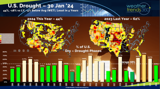
Drought made a huge improvement in the past couple weeks, with the U.S. now trending WET and least dry to drought phases in 4 years with just 44% of the country in drought phases vs 62% last year and 72% in 2022.
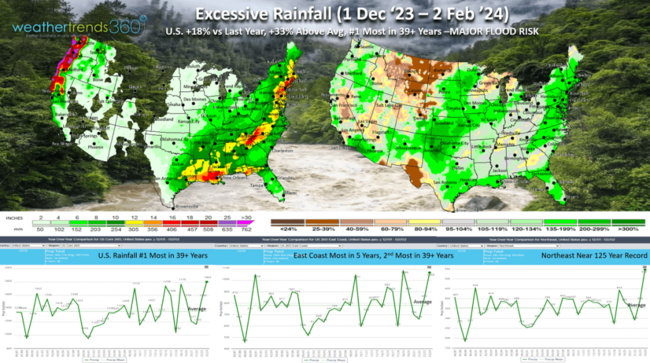
Winter (1 Dec '23 to 2 Feb '24) shows the U.S. trending the #1 wettest Winter in over 39 years. East Coast wettest in 5 years and the Northeast near record 125 year wet! Major flooding risk a big concern in early Spring, especially the Northeast.
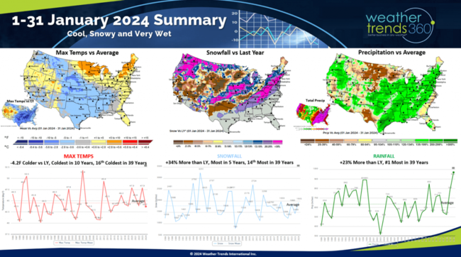
January 2024 is in the history books, and it was volatile with very warm periods but then brutal Polar Vortex cold. The calendar month overall trended -4.2F colder than last year for Max Temperatures, coldest in 10 years and 16th coldest of the past 39 years. Snowfall was +34% more than last year, most in 5 years and 14th most of the past 39 years. Rainfall was off the scale trending +23% wetter and #1 wettest in over 39 years. Cold, Wet, Snowy was certainly a huge plus for a huge spike in Winter seasonal merchandise.
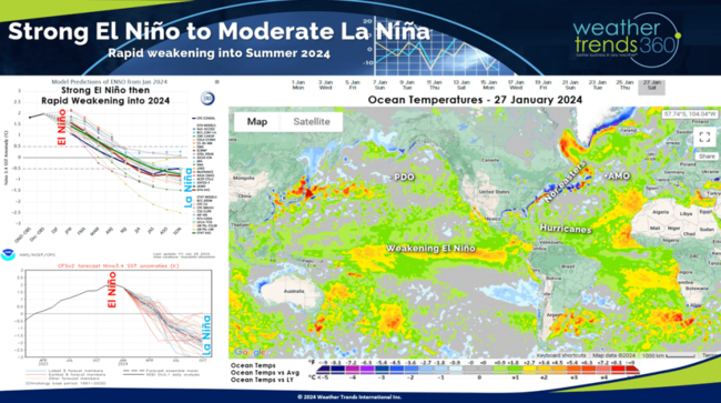
El Niño is collapsing quickly, and all signs point to a moderate La Niña by Summer. This rapid change in cycles will once again have major implications to the World's weather patterns.
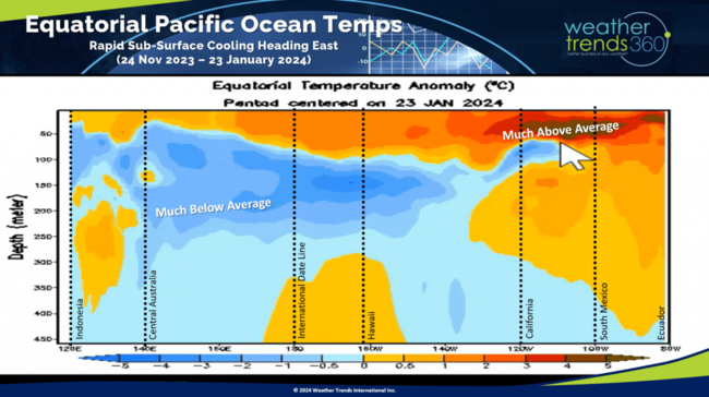
The models can be confirmed with a quick look of all the below average sub-surface Pacific Ocean temperatures making their way East and toward the surface of the Equatorial Pacific.
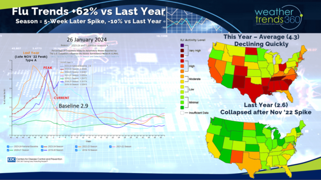
Flu has clearly peaked an collapsing quickly. The U.S. should be below baseline by middle February.
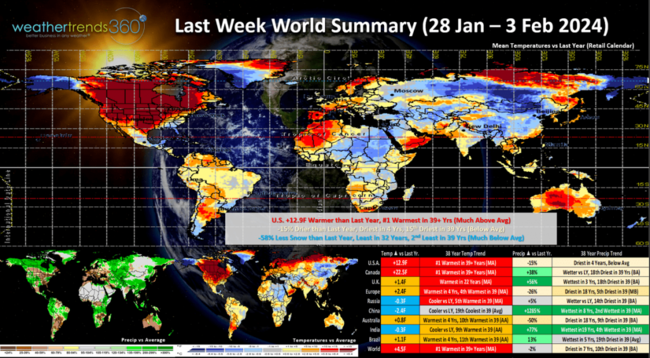
Last week (28 Jan - 3 Feb) across the World shows what happens when the Polar Vortex strengthens and becomes more symmetrical at the North Pole bottling up all the Arctic air. The U.S. was a significant +12.9F warmer than last year and #1 warmest of the past 39 years. Rainfall was down -15% vs LY and least in 4 years, while snowfall was -58% less and least in 32 years. Milder/drier weather is a huge benefit to store traffic at the expense of Winter seasonal merchandise. Canada was near record warm as was Western Europe.
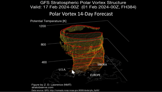
The Polar Vortex looks like it's about to weaken and elongate which will allow the Arctic air to begin heading back into the middle latitudes for the later half of February.
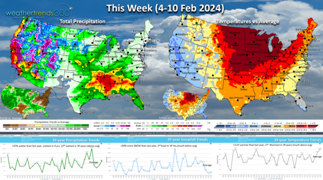
This week (4-10 Feb) shows the U.S. trending +3.2F warmer than last year and 2nd warmest of the past 39 years. Rainfall up +47% wetter, wettest in 4 years and 12th wettest of the past 39 with another big storm impacting the West Coast. Snowfall up +50% but still 3rd least of the past 39 years with heavy snow limited to the high elevations of the West, not major population centers.
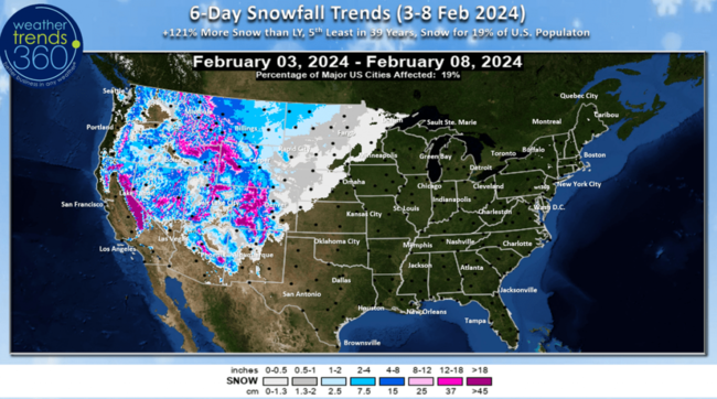
The 6-day Snowfall outlook (3-8 Feb) shows snow limited to the high elevations of the Western Mountains. +121% more than last year, but still 5th least of the past 39 years and only 19% of U.S. population impacted.
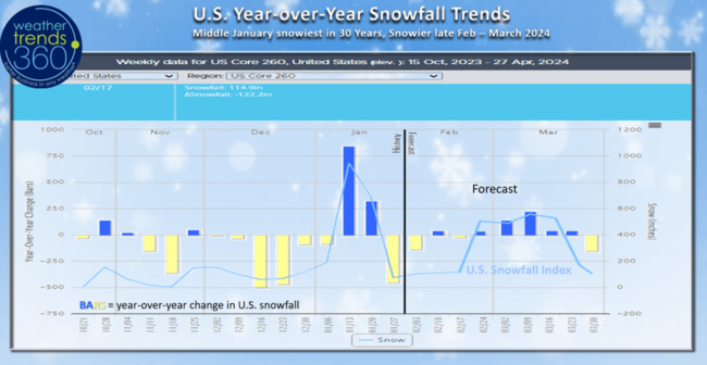
After the snowiest middle January in 30 years, national snowfall has trailed off, but we expect the snowier pattern to return for the latter half of February into middle March, especially in the Northeast.
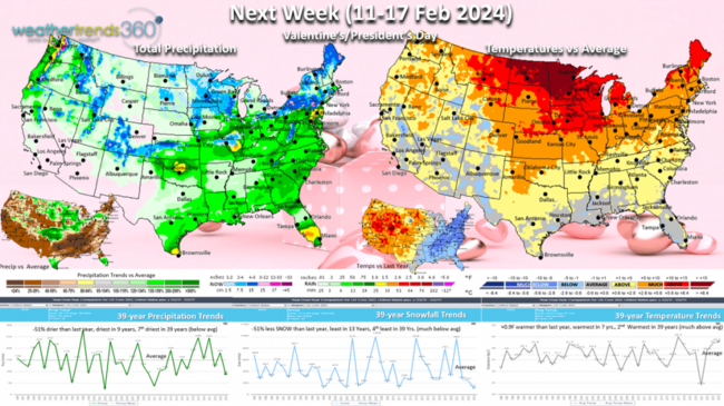
Next week (11-17 Feb) for Valentine's Day and President's Day looks warmer trending +0.9F warmer than last year, warmest in 7 years and 2nd warmest of the past 39 years. The East and Southeast will show a cooling trend through the week. Rainfall -51% less than a year ago and driest in 9 years while snowfall is also -51% less and least in 13 years. These are favorable trends for store traffic and holiday sales.
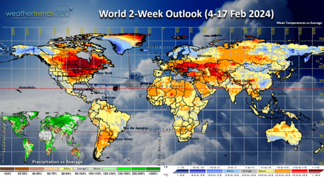
The World 2-week outlook (4-17 Feb) shows the Polar Vortex cold air is limited to Eastern Siberia, Alaska and Greenland, but should be making a move South mid month.
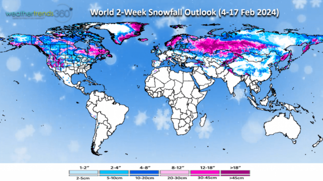
Mild doesn't mean no snow with plenty across Russia, Siberia, Eastern Canada and the Western U.S.
We hope you have a great week ahead, and don't forget to follow us on social media for frequent updates: Facebook, Twitter, YouTube, Pinterest and Linkedin.
- Captain Kirk out