Captain's Log 3 Aug '24 Cooling Trend for Some
Captain's Log
3 August 2024: Happy Saturday! :)
We've launched a new product for small businesses in the micr0brewery industry, now available on our Plans page! Our Power of 1 Degree® technology has proven time and time again, that every 1F warmer there's a 1-2% increase in cold beverage sales, 10F warmer 10% to 20% increases in year-over-year sales, but 10F colder a similar decrease. Daily report is emailed to you every morning.
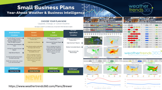
BrewCast offers short range weather and year-ahead weekly sales forecast along with a weekend event favorability forecast. CLICK ON IMAGES FOR A LARGER VIEW.
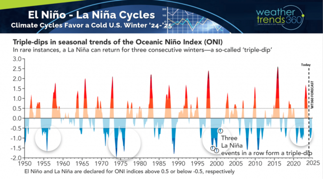
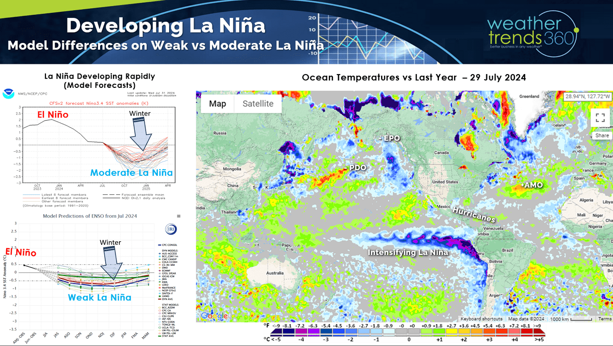
Out in the Equatorial Pacific, La Niña is brewing or should we say cooling as the oceans continue to cool with the exact opposite cycle to last year's El Niño.
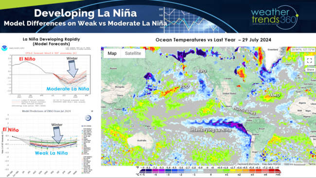
Models still show a weak to moderate and short-lived event this Fall into Winter which will bring a wholesale change to the Winter pattern ahead.
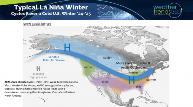
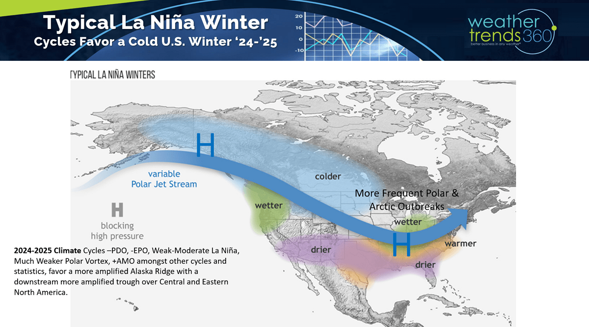
Not a fan of these generalized forecasts as there are so many climate cycles and factors to combine, but the general La Nina Winter theme is colder and potentially snowier for the Plains, Midwest, Great Lakes and Northeast with a general warmer/drier pattern across the South.
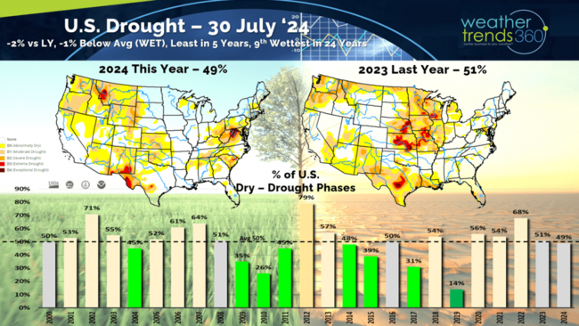
The good news the transitioning weather pattern here in 2024 was very favorable for the U.S. Corn Belt going from extreme drought last year to nearly ideal conditions this year. Yields are likely to break a record. This explains why Corn Prices have plummeted from $8.15 bu/ac back in 2022 to $3.90 bu/ac and 4-year lows today. Drought has shifted to the East and Northwest.
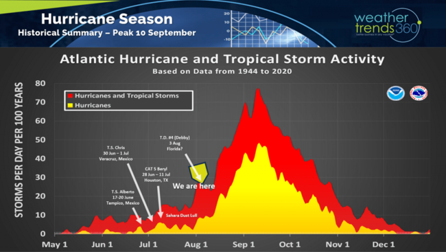
The bad news is the cycle favors a very active core Hurricane season from middle August to middle October. We're about to get our 4th named storm of the season (Debby) which will likely remain weak as it makes landfall in North Florida early Monday am. The only impact will be some flooding rains in the 5-9" range in the Coastal Southeast.
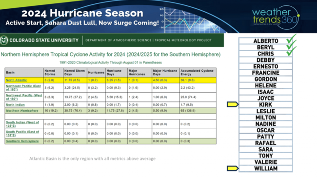
The Atlantic Basin is the only area in the World trending above average for all the core tropical activity metrics and that's about to ramp up significantly in the next few weeks.
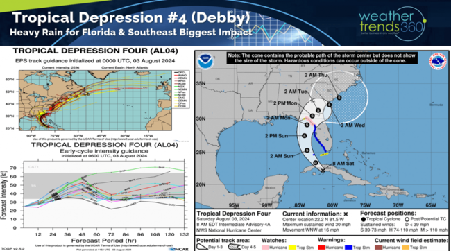
Tropical Depression #4 is over Cuba which is helping to keep this wave weak, but a Tropical Storm (Debby) a near certainty this weekend with landfall pre-dawn Monday in Florida. It then meanders in the Southeast with heavy rain the biggest impact.
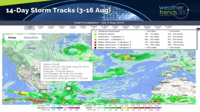
This time of year, we start to watch the tropical waves coming off Africa as they move out into the Atlantic. For now, Debby is the near-term threat.

Severe Weather in terms of tornadoes, hail and wind are nearing the end of the core season, but Tornado counts are still top 3% of history and the most in 13 years. Hail cases are down vs last year.

Last week (28 Jul - 3 Aug) across the World shows the U.S. trending +2.0F warmer than last year, warmest in 13 years and 2nd warmest of the past 39 years. Rainfall was up +25% vs last year, wettest in 6 years and 8th wettest of the past 39 years. The Northeast and Central Plains were the hot spots. Western Europe was warm, while Russia was the cool spot and Australia the coldest in 12 years.

Australia is having a colder back half of Winter after a warmer start which delayed their FLU season but now a strong spike in cases. Their season has been very similar to the U.S. season last year in terms of timing and intensity with another Type A season like the U.S. had last year. Usually this is an indicator for our season ahead. With a colder late Fall and Winter, the U.S. likely to have an earlier start in November and a slightly later peak in January.
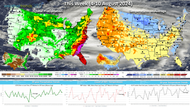
This week (4-10 Aug) across the U.S. shows national temperatures trending down -0.1F vs last year, coolest in 4 years and 17th warmest of the past 39 years. A big cool down for the Upper Midwest, Great Lakes and eventually the Northeast. The heat intensifies again in the West. Hot 90F days are up nationally over last year's not so hot trend. Rainfall down -11% vs last year but still 9th wettest of the past 39 years with the East Coast having the heaviest rainfall due to soon to be Tropical Storm Debby.
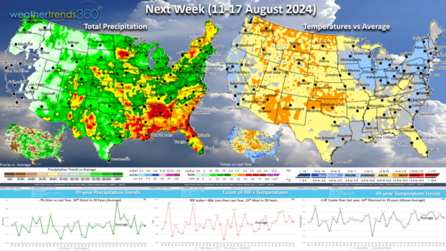
Next week (11-17 Aug) it remains cooler in the Great Lakes - Northeast with a cool down for California as well. The U.S. overall trends -1.0F cooler than last year, 14th warmest of the past 39 years. Rainfall -7% vs last year and 18th driest of the past 39 years. Continued heavy rain in the Southeast.
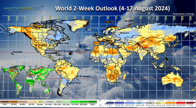
The World 2-week outlook (4-17 Aug) shows the coolest weather will be in Eastern Canada and the Northeast U.S. with hotter weather for Western North America.
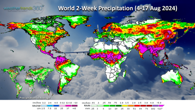
World 2-week rainfall (4-17) shows the extreme rainfall trends diminishing a bit which is likely a sign that the atmosphere is starting to respond to the La Niña cycle.
We hope you have a great week ahead, and don't forget to follow us on social media for frequent updates: Facebook, Twitter, YouTube, Pinterest and Linkedin.
- Captain Kirk out.
We've launched a new product for small businesses in the micr0brewery industry, now available on our Plans page! Our Power of 1 Degree® technology has proven time and time again, that every 1F warmer there's a 1-2% increase in cold beverage sales, 10F warmer 10% to 20% increases in year-over-year sales, but 10F colder a similar decrease. Daily report is emailed to you every morning.
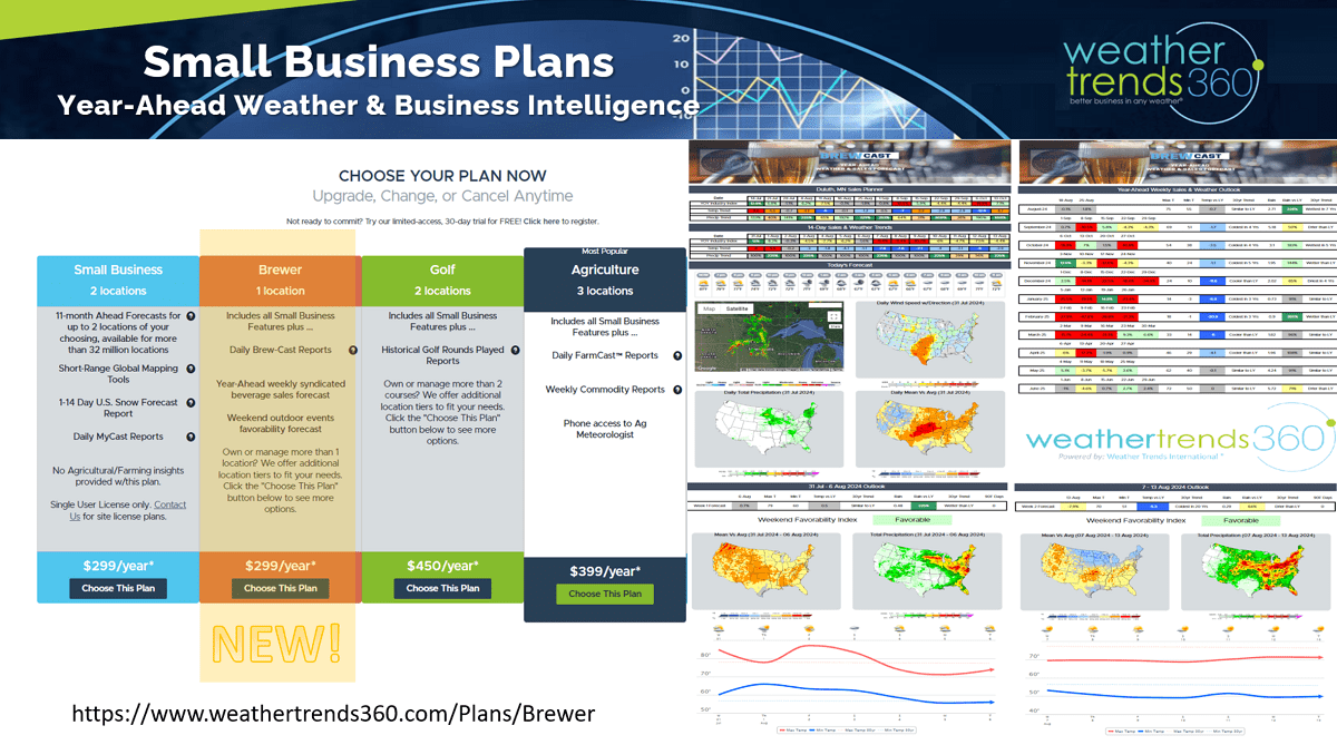
BrewCast offers short range weather and year-ahead weekly sales forecast along with a weekend event favorability forecast. CLICK ON IMAGES FOR A LARGER VIEW.

Out in the Equatorial Pacific, La Niña is brewing or should we say cooling as the oceans continue to cool with the exact opposite cycle to last year's El Niño.
Models still show a weak to moderate and short-lived event this Fall into Winter which will bring a wholesale change to the Winter pattern ahead.
Not a fan of these generalized forecasts as there are so many climate cycles and factors to combine, but the general La Nina Winter theme is colder and potentially snowier for the Plains, Midwest, Great Lakes and Northeast with a general warmer/drier pattern across the South.
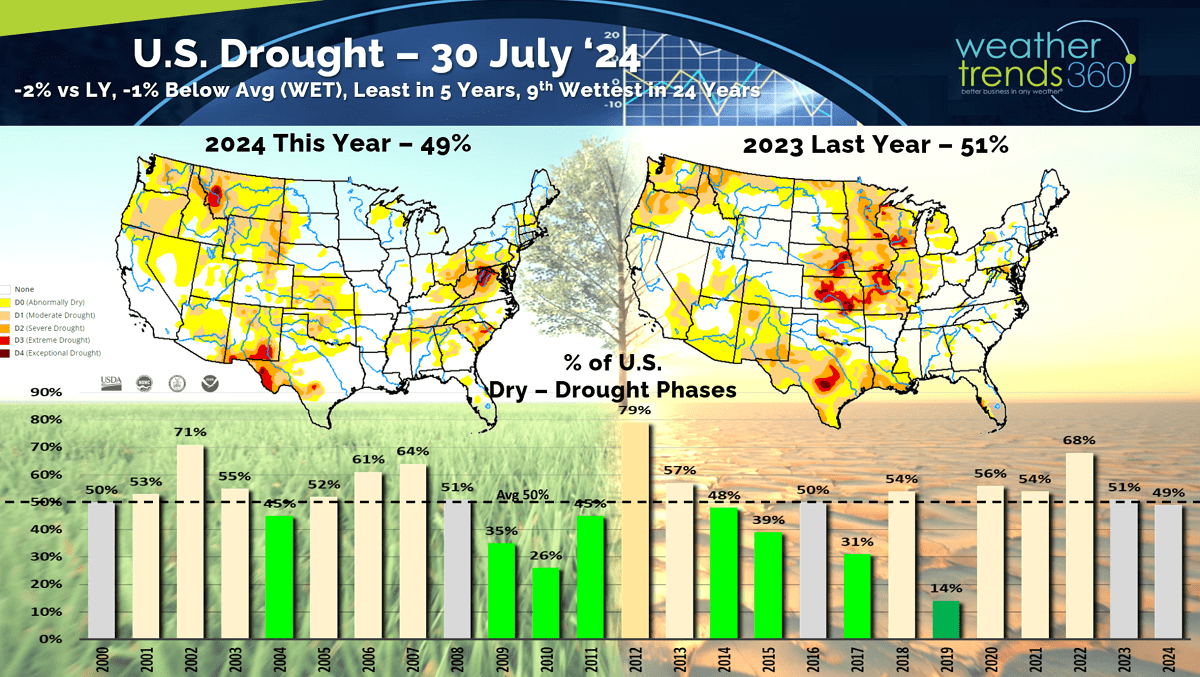
The good news the transitioning weather pattern here in 2024 was very favorable for the U.S. Corn Belt going from extreme drought last year to nearly ideal conditions this year. Yields are likely to break a record. This explains why Corn Prices have plummeted from $8.15 bu/ac back in 2022 to $3.90 bu/ac and 4-year lows today. Drought has shifted to the East and Northwest.

The bad news is the cycle favors a very active core Hurricane season from middle August to middle October. We're about to get our 4th named storm of the season (Debby) which will likely remain weak as it makes landfall in North Florida early Monday am. The only impact will be some flooding rains in the 5-9" range in the Coastal Southeast.

The Atlantic Basin is the only area in the World trending above average for all the core tropical activity metrics and that's about to ramp up significantly in the next few weeks.
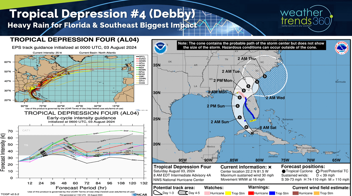
Tropical Depression #4 is over Cuba which is helping to keep this wave weak, but a Tropical Storm (Debby) a near certainty this weekend with landfall pre-dawn Monday in Florida. It then meanders in the Southeast with heavy rain the biggest impact.
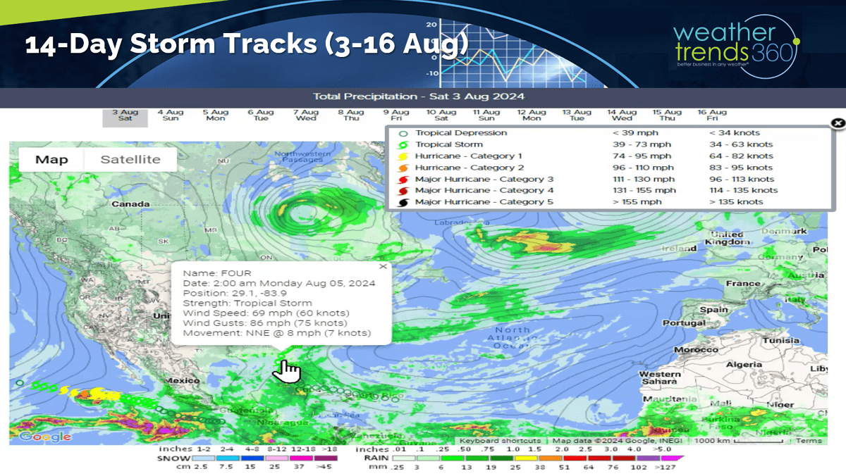
This time of year, we start to watch the tropical waves coming off Africa as they move out into the Atlantic. For now, Debby is the near-term threat.
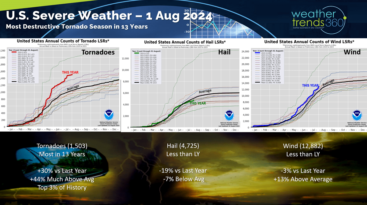
Severe Weather in terms of tornadoes, hail and wind are nearing the end of the core season, but Tornado counts are still top 3% of history and the most in 13 years. Hail cases are down vs last year.
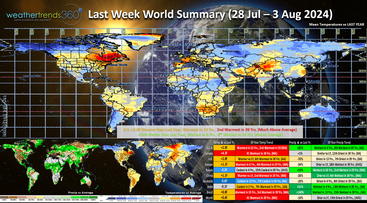
Last week (28 Jul - 3 Aug) across the World shows the U.S. trending +2.0F warmer than last year, warmest in 13 years and 2nd warmest of the past 39 years. Rainfall was up +25% vs last year, wettest in 6 years and 8th wettest of the past 39 years. The Northeast and Central Plains were the hot spots. Western Europe was warm, while Russia was the cool spot and Australia the coldest in 12 years.
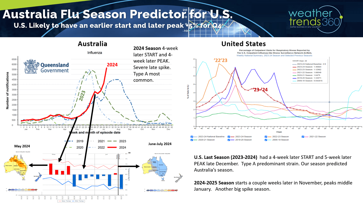
Australia is having a colder back half of Winter after a warmer start which delayed their FLU season but now a strong spike in cases. Their season has been very similar to the U.S. season last year in terms of timing and intensity with another Type A season like the U.S. had last year. Usually this is an indicator for our season ahead. With a colder late Fall and Winter, the U.S. likely to have an earlier start in November and a slightly later peak in January.
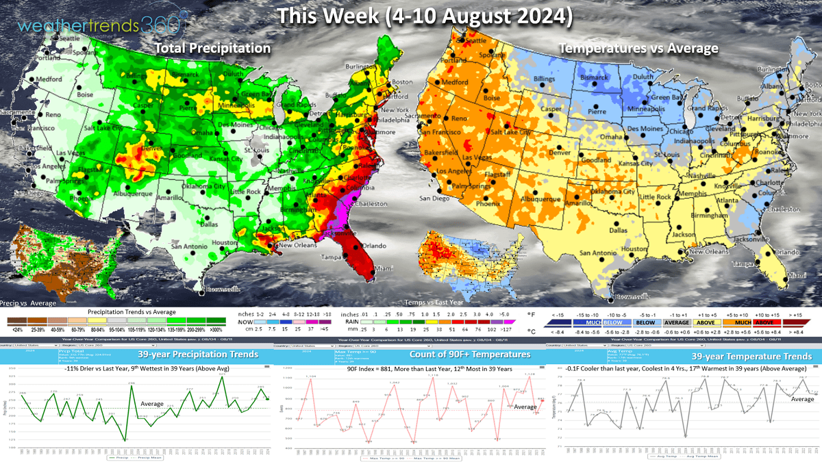
This week (4-10 Aug) across the U.S. shows national temperatures trending down -0.1F vs last year, coolest in 4 years and 17th warmest of the past 39 years. A big cool down for the Upper Midwest, Great Lakes and eventually the Northeast. The heat intensifies again in the West. Hot 90F days are up nationally over last year's not so hot trend. Rainfall down -11% vs last year but still 9th wettest of the past 39 years with the East Coast having the heaviest rainfall due to soon to be Tropical Storm Debby.

Next week (11-17 Aug) it remains cooler in the Great Lakes - Northeast with a cool down for California as well. The U.S. overall trends -1.0F cooler than last year, 14th warmest of the past 39 years. Rainfall -7% vs last year and 18th driest of the past 39 years. Continued heavy rain in the Southeast.
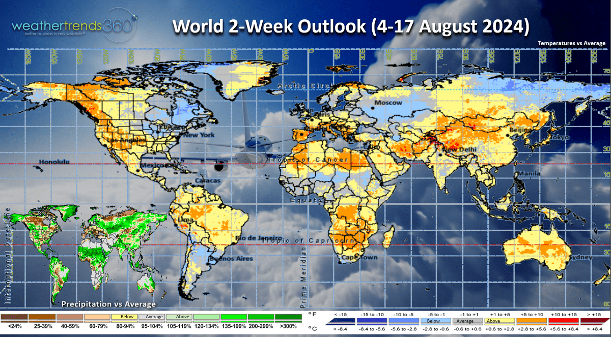
The World 2-week outlook (4-17 Aug) shows the coolest weather will be in Eastern Canada and the Northeast U.S. with hotter weather for Western North America.

World 2-week rainfall (4-17) shows the extreme rainfall trends diminishing a bit which is likely a sign that the atmosphere is starting to respond to the La Niña cycle.
We hope you have a great week ahead, and don't forget to follow us on social media for frequent updates: Facebook, Twitter, YouTube, Pinterest and Linkedin.
- Captain Kirk out.