Captain's Log 28 Oct '23 #1 Hottest Q3 but COLD Start to Q4
Captain's Log
28 Oct '23: Happy Saturday! :)
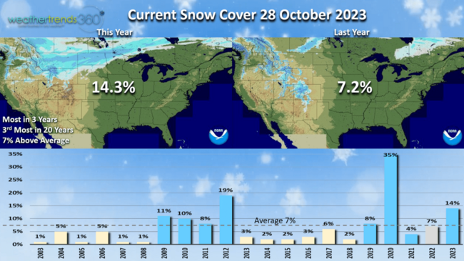
It's a snowy end to October for some with the 14.3% of the U.S. blanketed in snow, up from 7.2% last year, most in 3 years and 3rd most in 20 years. CLICK ON IMAGES FOR A LARGER VIEW.
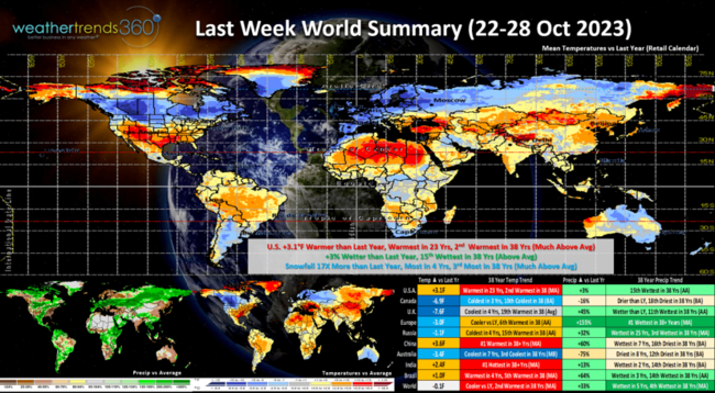
Last week (22-28 Oct) World Summary shows the U.S. trending +3.1F warmer than last year, warmest in 23 years and 2nd warmest in 38 years. These are very unfavorable temperatures for retail seasonal sales. Rainfall was +3% vs last year and 15th wettest of the past 38 years. The season's first big snowstorm moved out of the Rockies into the Plains with national snowfall a whopping 17x more than last year, most in 4 years and 3rd most in 38 years. Cold across Canada and down under in Australia.
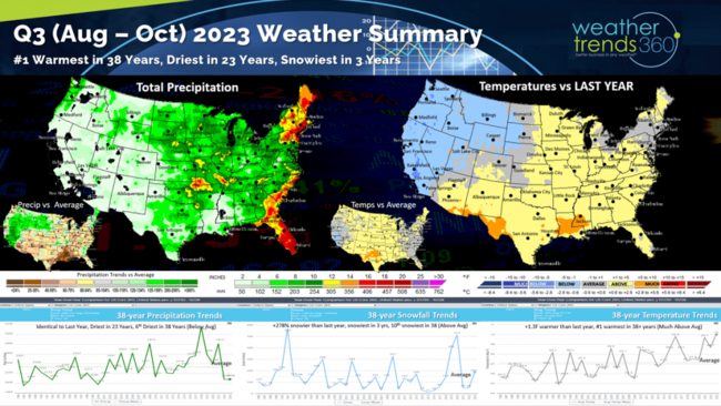
Q3 (30 July - 28 October) 2023 is in the history books and the weather wasn't great for Fall seasonal sales. Great for Summer clearance as it was +1.3F hotter than last year and #1 hottest of the past 38 years. Rainfall was similarly dry to last year, driest in 23 years and 6th driest of the past 38 years. Snowfall was up late trending +278% more than last year, snowiest in 3 years and 10th snowiest of the past 38 years. Overall the temperature trends were very unfavorable for overall retail seasonal sales. This time of year, cold/wet and snowy is ideal.
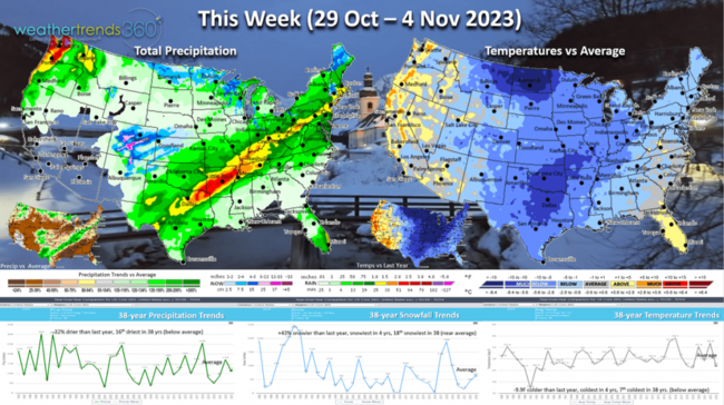
This week (29 Oct - 3 Nov) gets off to a very strong start for Q4 with national temperatures trending a very significant -9.9F colder than last year, coldest in 4 years and 7th coldest of the past 38 years. This is one of the top 2 strongest year-over-year sales gains weeks for all of Q4. Rainfall -32% less than last year and 16th driest of the past 38. Snowfall still up +43% vs last year, most in 4 years and 18th snowiest of the past 38 with near average national snowfall. Even the interior Northeast will get the first snow of the season midweek.
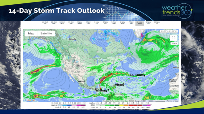
 The tropics are still very much alive here in the final month of the very active 2023 season. Tropical Storm Tammy is still meandering well East of Bermuda. T.S. Vince would be next with a promising system East of the Bahamas this week.
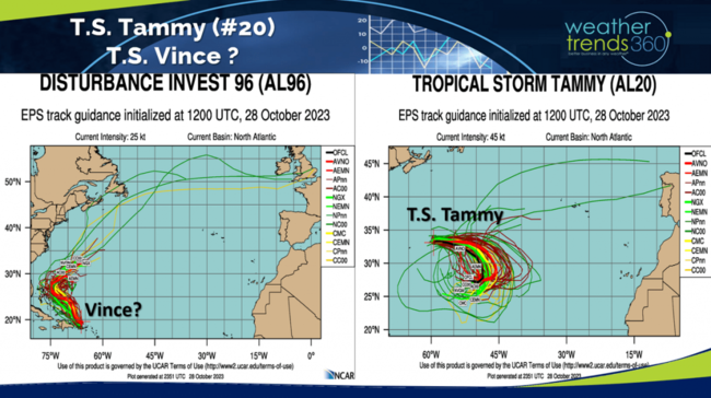
Next week we need to watch for a stronger system heading toward Florida. TBD if that will become Whitney, the last name available from the National Hurricane Center (NHC) list.
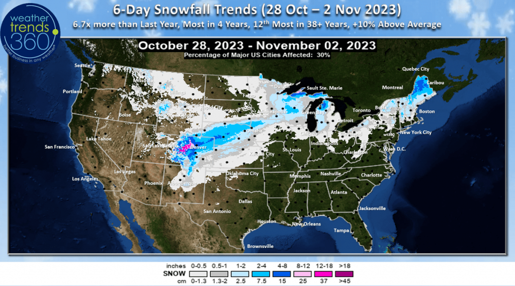
The 6-day snowfall outlook shows the Rocky Mountain storm spilling out into the Central Plains and even into New England. The 6-day snowfall totals (28 Oct - 2 Nov) are 6.7X more than last year, most in 4 years, 12th most in 38 years trending +10% above average.
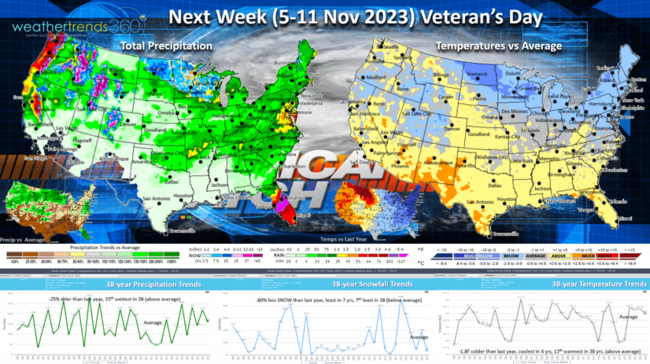
 Next week (5-11 Nov) shows some moderation, but Temperatures still trending -1.8F cooler than last year, coolest in 4 years but 13th warmest of the past 38 years. The Northeast and Great Lakes are the most favorable spots for stronger seasonal merchandise sales. Rainfall -25% drier than last year, but still 15th wettest of the past 38 years. Need to watch Florida for a tropical system. National snowfall down -80% vs last year, least in 7 years and 7th least of the past 38 years.
A barrage of event starts with the end of Daylight Savings Time on the 5th,

Election day on the 7th

and Veteran's Day on the 11th.

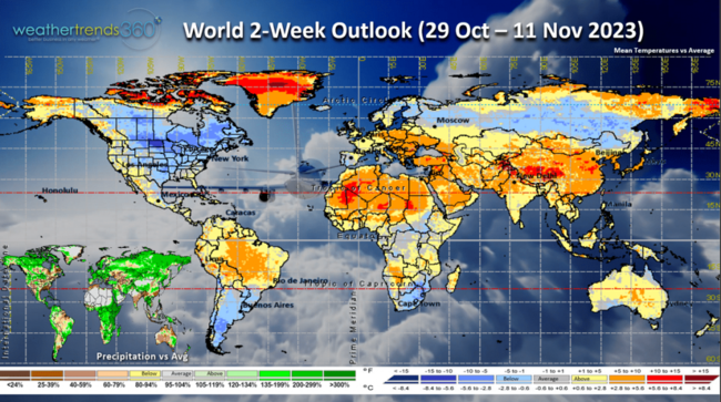
The World 2-week outlook (29 Oct - 11 Nov) shows the U.S. and Canada are favorable for cold weather category sales while Europe turns much less favorable.
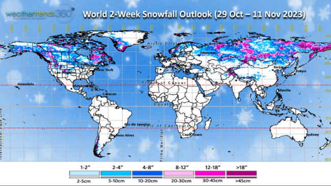
The World 2-week snowfall outlook continues to show snow pilling up in Siberia which is one of dozens of climate indices that help to predict the U.S. Winter. More early snow in Siberia allows for strong Arctic cold fronts into North America in the Winter months ahead!
Have a great week ahead, and don't forget to follow us on social media for frequent updates: Facebook, Twitter, YouTube, Pinterest and Linkedin.
- Captain Kirk out
It's a snowy end to October for some with the 14.3% of the U.S. blanketed in snow, up from 7.2% last year, most in 3 years and 3rd most in 20 years. CLICK ON IMAGES FOR A LARGER VIEW.

Last week (22-28 Oct) World Summary shows the U.S. trending +3.1F warmer than last year, warmest in 23 years and 2nd warmest in 38 years. These are very unfavorable temperatures for retail seasonal sales. Rainfall was +3% vs last year and 15th wettest of the past 38 years. The season's first big snowstorm moved out of the Rockies into the Plains with national snowfall a whopping 17x more than last year, most in 4 years and 3rd most in 38 years. Cold across Canada and down under in Australia.

Q3 (30 July - 28 October) 2023 is in the history books and the weather wasn't great for Fall seasonal sales. Great for Summer clearance as it was +1.3F hotter than last year and #1 hottest of the past 38 years. Rainfall was similarly dry to last year, driest in 23 years and 6th driest of the past 38 years. Snowfall was up late trending +278% more than last year, snowiest in 3 years and 10th snowiest of the past 38 years. Overall the temperature trends were very unfavorable for overall retail seasonal sales. This time of year, cold/wet and snowy is ideal.

This week (29 Oct - 3 Nov) gets off to a very strong start for Q4 with national temperatures trending a very significant -9.9F colder than last year, coldest in 4 years and 7th coldest of the past 38 years. This is one of the top 2 strongest year-over-year sales gains weeks for all of Q4. Rainfall -32% less than last year and 16th driest of the past 38. Snowfall still up +43% vs last year, most in 4 years and 18th snowiest of the past 38 with near average national snowfall. Even the interior Northeast will get the first snow of the season midweek.
 The tropics are still very much alive here in the final month of the very active 2023 season. Tropical Storm Tammy is still meandering well East of Bermuda. T.S. Vince would be next with a promising system East of the Bahamas this week.
Next week we need to watch for a stronger system heading toward Florida. TBD if that will become Whitney, the last name available from the National Hurricane Center (NHC) list.

The 6-day snowfall outlook shows the Rocky Mountain storm spilling out into the Central Plains and even into New England. The 6-day snowfall totals (28 Oct - 2 Nov) are 6.7X more than last year, most in 4 years, 12th most in 38 years trending +10% above average.
 Next week (5-11 Nov) shows some moderation, but Temperatures still trending -1.8F cooler than last year, coolest in 4 years but 13th warmest of the past 38 years. The Northeast and Great Lakes are the most favorable spots for stronger seasonal merchandise sales. Rainfall -25% drier than last year, but still 15th wettest of the past 38 years. Need to watch Florida for a tropical system. National snowfall down -80% vs last year, least in 7 years and 7th least of the past 38 years.
A barrage of event starts with the end of Daylight Savings Time on the 5th,

Election day on the 7th

and Veteran's Day on the 11th.

The World 2-week outlook (29 Oct - 11 Nov) shows the U.S. and Canada are favorable for cold weather category sales while Europe turns much less favorable.

The World 2-week snowfall outlook continues to show snow pilling up in Siberia which is one of dozens of climate indices that help to predict the U.S. Winter. More early snow in Siberia allows for strong Arctic cold fronts into North America in the Winter months ahead!

Have a great week ahead, and don't forget to follow us on social media for frequent updates: Facebook, Twitter, YouTube, Pinterest and Linkedin.
- Captain Kirk out