Captain's Log 28 Jan '23 Warmest January in 17 Years...What's Next?
Captain's Log
28 January 2023: Happy last Saturday in January 2023! :)
If you're already counting down to Spring...you have 51 days 4 hours 12 minutes and 30 seconds to go if you play by the Sun's seasons. If you like the weatherman's seasons you have 31 days 12 hours and 15 minutes! CLICK ON IMAGES FOR A LARGER VIEW.
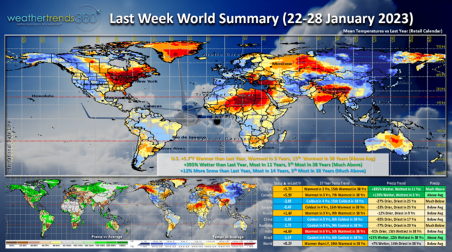
 Last week (22-28 Jan) across the World shows the U.S. trending +5.7F warmer than last year, warmest in 3 years and 15th warmest of the past 38 years. Rainfall was up +395% over last year, wettest in 11 years and 5th most of the past 38, a sign the 3-year La Nina cycle is collapsing. A couple of snow storms traversing from the South Central U.S. into New England had snowfall up +12% more than last year, most in 14 years and 5th most of the past 38 years. A great week for snowfall category sales! The U.K. and Europe were the coldest in 4 years.
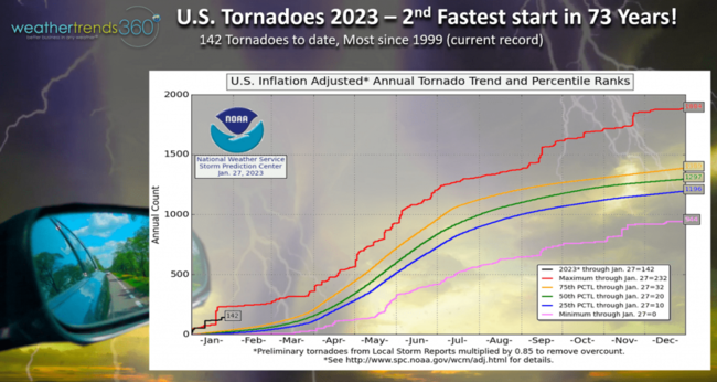
With the clash of cold air in the West and very warm and moist air in the Southeast, tornadoes are off to a near record start with 142 so far, most in 24 years and 2nd most in 73 year. Most have been in the Southeastern U.S. This active start is very likely to continue this Spring with wt360 projecting the most active season likely in 4 years, up 19% over last year.
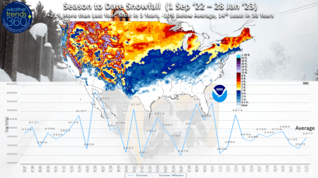
Season to date snowfall picked up some ground with the two wintry storms boosting the trends to +21% more than last year, most in 3 years but still -10% below average and 14th least of the past 38 years. The West higher elevations have been the big winner this year and downwind of the Great Lakes, while the big cities from D.C. to New York are much below average.
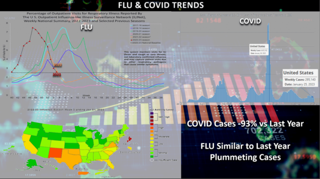
FLU continues to plummet after the very early biggest spike in cases since 2009. Cases continue to fall and likely to go below baseline in early February. COVID cases continue to trend a whopping -93% below last year's huge Omicron spike. This is good news as a healthier population is out and about more with the milder January weather which tends to boost overall GDP and store traffic.
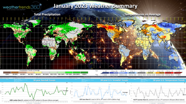
January 2023 is just about in the weather history books with the U.S. trending +6.5F warmer than last year, warmest in 17 years and 3rd warmest of the past 38 with much above average national temperatures. The West and Rockies were the cold spot while the East was very mild by January standards. Despite the heavy mountain snow out West, U.S. snowfall was -22% less than last year, least in 10 year and 9th least of the past 38 years. Rainfall was up +68% over last year, wettest in 6 years and 8th wettest of the past 38 years a sign the 3-year La Niña drought cycle is collapsing.
The month ended colder for the North Central U.S. as the Polar Vortex made a glancing blow into the Northern Hemisphere. The PV will begin to lift out of the U.S. by the 2nd week of February with just a brief cool down in the Northeast.
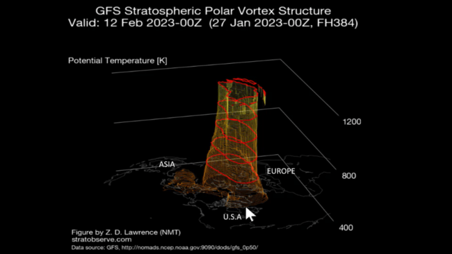
It appears to get stronger again which would pull the cold weather back into Northeast Siberia.
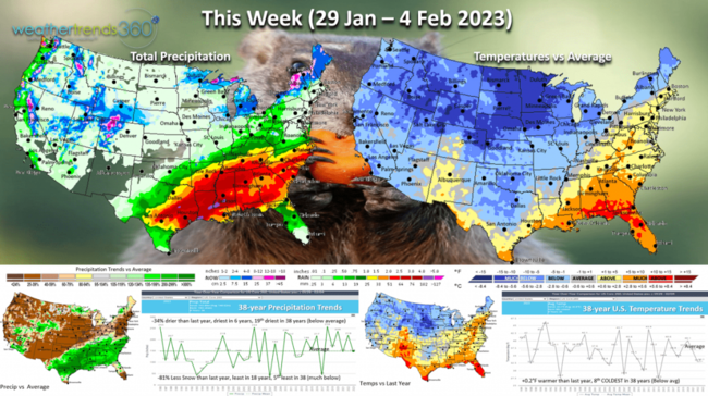
This week (29 Jan - 4 Feb) shows the frigid air in the North Central U.S. with some trying to get into the interior Northeast. The U.S. overall trends +0.2F warmer than last year's really cold end to January and 8th coldest of the past 38 years. Despite very storm conditions continuing in the South, national rainfall is -34% drier than last year, least in 6 years and 19th driest of the past 38 years. Snowfall down a whopping -81% vs last year and least in 18 years. Overall an OK week for Winter merchandise clearance sales.
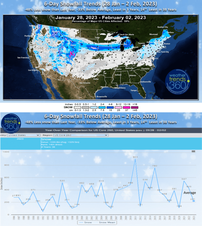
The 6-day snowfall outlook shows some moderate 4-8"+ amounts in a narrow band from South Dakota into Central Michigan and the interior Northeast. Still -48% less than last year, -33% below average, least in 3 years and 14th least of the past 38 years.
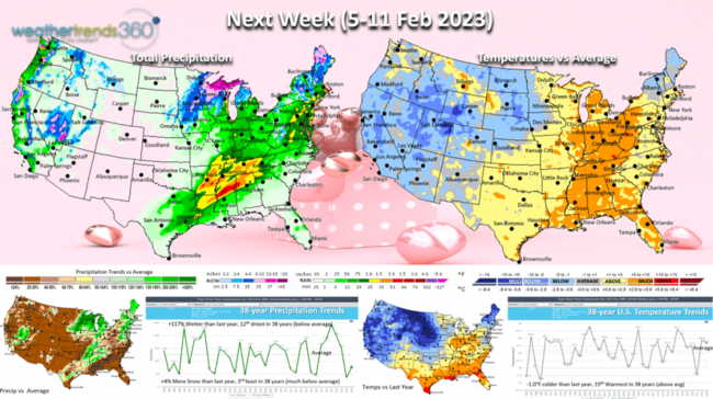
Next week (5-11 Feb) before Valentine's Day shows a moderating trend in the Eastern half of the U.S. with national temperatures -1.0F colder than a year ago but 15th warmest of the past 38 years. Rainfall up +117% over last year but still 12th driest of the past 38 years. Snowfall up a bit over last year but still well below average and 3rd least of the past 38 years.
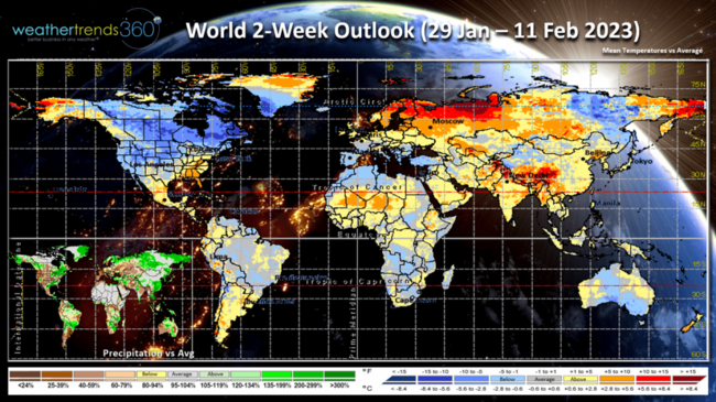
The World 2-week outlook (29 Jan - 11 Feb) shows the influence of the Polar Vortex over North America and Northeast Siberia, but this will begin to lift out as we go into the 2nd week of February. Generally milder in Eastern Europe vs Western Europe with the Mediterranean area generally cool.
We hope you have a great week, and don't forget to follow us on social media for frequent updates: Facebook, Twitter, YouTube, Pinterest and Linkedin.
- Captain Kirk out.
If you're already counting down to Spring...you have 51 days 4 hours 12 minutes and 30 seconds to go if you play by the Sun's seasons. If you like the weatherman's seasons you have 31 days 12 hours and 15 minutes! CLICK ON IMAGES FOR A LARGER VIEW.
 Last week (22-28 Jan) across the World shows the U.S. trending +5.7F warmer than last year, warmest in 3 years and 15th warmest of the past 38 years. Rainfall was up +395% over last year, wettest in 11 years and 5th most of the past 38, a sign the 3-year La Nina cycle is collapsing. A couple of snow storms traversing from the South Central U.S. into New England had snowfall up +12% more than last year, most in 14 years and 5th most of the past 38 years. A great week for snowfall category sales! The U.K. and Europe were the coldest in 4 years.
With the clash of cold air in the West and very warm and moist air in the Southeast, tornadoes are off to a near record start with 142 so far, most in 24 years and 2nd most in 73 year. Most have been in the Southeastern U.S. This active start is very likely to continue this Spring with wt360 projecting the most active season likely in 4 years, up 19% over last year.

Season to date snowfall picked up some ground with the two wintry storms boosting the trends to +21% more than last year, most in 3 years but still -10% below average and 14th least of the past 38 years. The West higher elevations have been the big winner this year and downwind of the Great Lakes, while the big cities from D.C. to New York are much below average.

FLU continues to plummet after the very early biggest spike in cases since 2009. Cases continue to fall and likely to go below baseline in early February. COVID cases continue to trend a whopping -93% below last year's huge Omicron spike. This is good news as a healthier population is out and about more with the milder January weather which tends to boost overall GDP and store traffic.

January 2023 is just about in the weather history books with the U.S. trending +6.5F warmer than last year, warmest in 17 years and 3rd warmest of the past 38 with much above average national temperatures. The West and Rockies were the cold spot while the East was very mild by January standards. Despite the heavy mountain snow out West, U.S. snowfall was -22% less than last year, least in 10 year and 9th least of the past 38 years. Rainfall was up +68% over last year, wettest in 6 years and 8th wettest of the past 38 years a sign the 3-year La Niña drought cycle is collapsing.

The month ended colder for the North Central U.S. as the Polar Vortex made a glancing blow into the Northern Hemisphere. The PV will begin to lift out of the U.S. by the 2nd week of February with just a brief cool down in the Northeast.

It appears to get stronger again which would pull the cold weather back into Northeast Siberia.

This week (29 Jan - 4 Feb) shows the frigid air in the North Central U.S. with some trying to get into the interior Northeast. The U.S. overall trends +0.2F warmer than last year's really cold end to January and 8th coldest of the past 38 years. Despite very storm conditions continuing in the South, national rainfall is -34% drier than last year, least in 6 years and 19th driest of the past 38 years. Snowfall down a whopping -81% vs last year and least in 18 years. Overall an OK week for Winter merchandise clearance sales.

The 6-day snowfall outlook shows some moderate 4-8"+ amounts in a narrow band from South Dakota into Central Michigan and the interior Northeast. Still -48% less than last year, -33% below average, least in 3 years and 14th least of the past 38 years.

Next week (5-11 Feb) before Valentine's Day shows a moderating trend in the Eastern half of the U.S. with national temperatures -1.0F colder than a year ago but 15th warmest of the past 38 years. Rainfall up +117% over last year but still 12th driest of the past 38 years. Snowfall up a bit over last year but still well below average and 3rd least of the past 38 years.

The World 2-week outlook (29 Jan - 11 Feb) shows the influence of the Polar Vortex over North America and Northeast Siberia, but this will begin to lift out as we go into the 2nd week of February. Generally milder in Eastern Europe vs Western Europe with the Mediterranean area generally cool.
We hope you have a great week, and don't forget to follow us on social media for frequent updates: Facebook, Twitter, YouTube, Pinterest and Linkedin.
- Captain Kirk out.