Captain's Log 27 Jul '24 Cooler Reprieve Ending with Heat Returning
Captain's Log
27 July 2024: Happy Saturday! :)
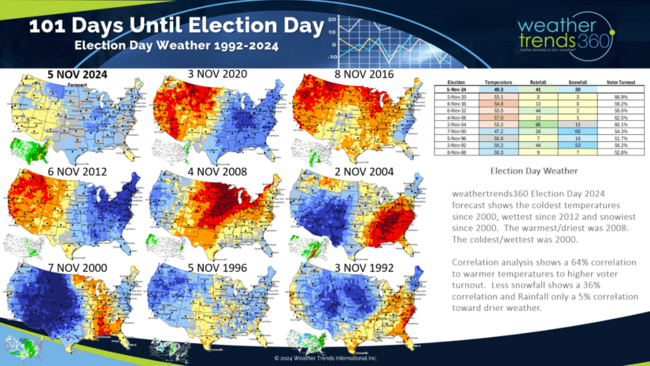
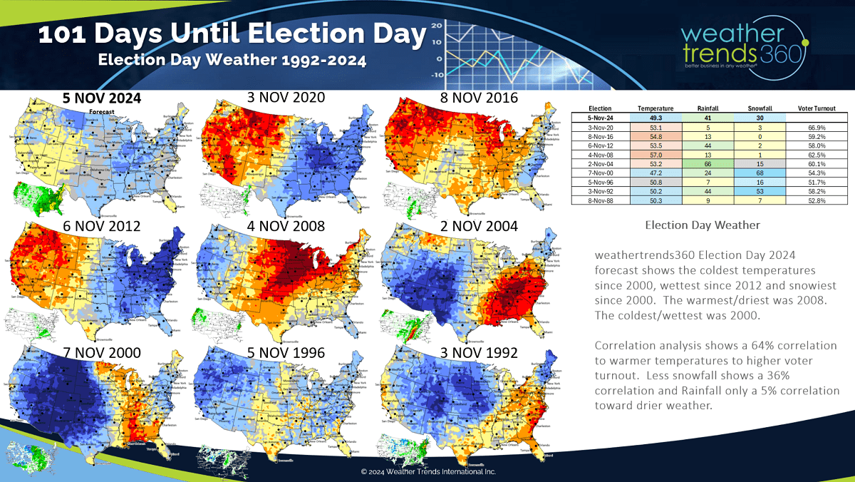
Election day is just 101 days away and it lo0ks statistically cool and stormy. A comparison of the past 9 Presidential election cycles shows 2024 could be the coolest and snowiest since 2000 and wettest since 2012. Temperature trends from 1992 show the highest correlations to voter turnout with a 64% relationship toward colder weather being less favorable. Snowfall showed a 36% correlation with less snow better and only 5% correlation to drier weather. CLICK ON IMAGES FOR A LARGER VIEW.
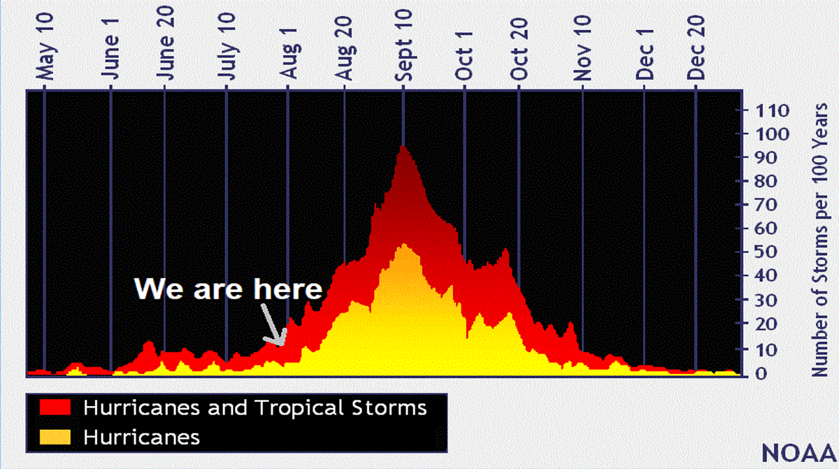
We're getting close to the core Hurricane Season from middle August to middle October which historically ramps up during this period.
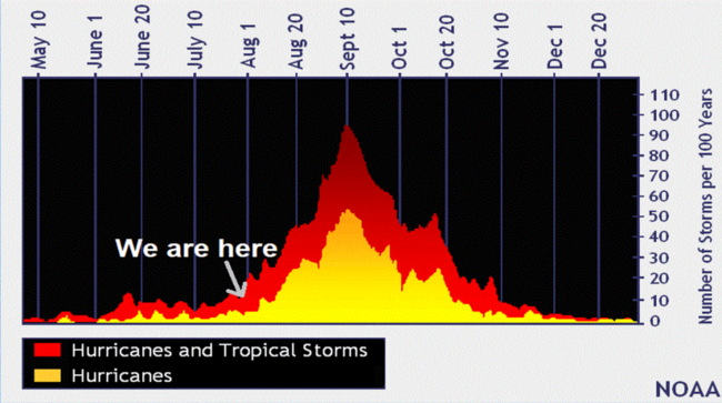
The National Hurricane Center is monitoring one minor threat area that could impact the Caribbean.

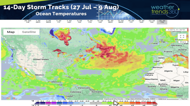
The 14-day storm tracks and ocean temperatures continue show the Bermuda High and Sahara Africa dust suppressing activity, but that is typical in July. The pattern looks to become more favorable for development in a couple weeks.
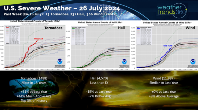
Severe Weather last week diminished a bit with 23 tornadoes, 231 hail events and 300 wind events. Tornadoes continue to rank the most in 13 years and in the top 3 of history while Hail cases are down -19% vs last year.
Last Week (21-27 July) across the World shows the U.S. getting a reprieve from the heat for some with national temperatures trending -2F cooler than last year, coolest in 5 years and 18th warmest of the past 39 years. The hot spot was the Northern Rockies and California while Texas to New England was on the cooler side. Rainfall was up +52% vs last year, wettest in 4 years and 9th wettest of the past 39 years.
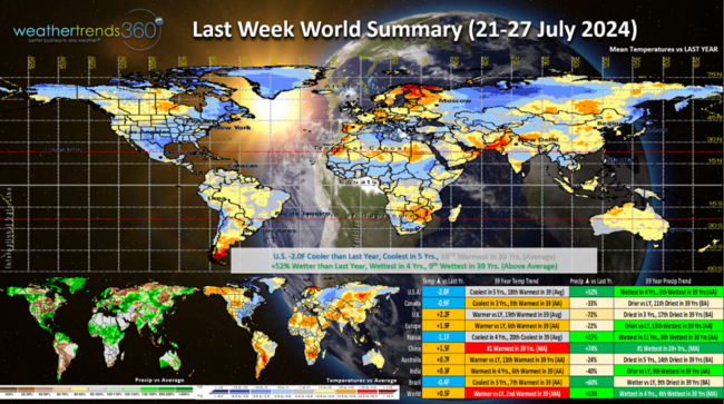
China was the hot spot trending #1 hottest and #1 wettest in 39 years with impacts from Typhoon Gaemi that hit the Philippines and Taiwan.
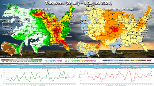
This week (28 Jul - 3 Aug) shows a warming trend with the heat moving back into the Central Plains and interior Northeast. Nothing compared to the June heat-waves but still has the U.S. trending +1.9F warmer than last year, warmest in 13 years and 3rd warmest of the past 39 years. Rainfall again up +22% vs last year, wettest in 4 years and 9th wettest of the past 39 years. Heaviest rain from Florida to Minnesota. Hot/wet weather is favorable for consumable food and beverage categories.
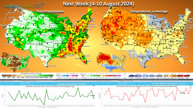
Next week (4-10 Aug) shows the heat expanding to the West while another cool front moves into the Great Lakes where there have been very few hot 90F days this year vs last year. U.S. temperatures look to trend +3.1F warmer than last year, warmest in 23 years and 2nd warmest of the past 39 years. Rainfall down -32% vs last year, least in 14 years and 14th driest of the past 39 years. The stormiest weather is in the East and more much needed rainfall for the drought areas of the Southeast.

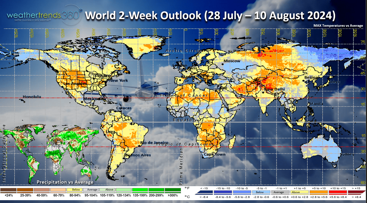
The World 2-week outlook (28 Jul - 10 Aug) shows a generally warm pattern for most areas of the World. Australia (Winter), NE Siberia and Alaska look to have below average temperatures. Australia had the coolest Fall and front half of Winter in 12 years which in part explains why their Flu season is up +14% vs last year with mostly Type A cases and the most active many years. This is one predictor for the U.S. season ahead.

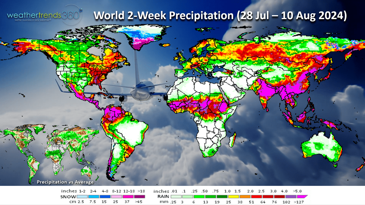
World 2-week Rainfall (28 Jul - 10 Aug) shows wet conditions for the Eastern half of the U.S. and dry West.
We hope you have a great week ahead, and don't forget to follow us on social media for frequent updates: Facebook, Twitter, YouTube, Pinterest and Linkedin.
- Captain Kirk out.
Election day is just 101 days away and it lo0ks statistically cool and stormy. A comparison of the past 9 Presidential election cycles shows 2024 could be the coolest and snowiest since 2000 and wettest since 2012. Temperature trends from 1992 show the highest correlations to voter turnout with a 64% relationship toward colder weather being less favorable. Snowfall showed a 36% correlation with less snow better and only 5% correlation to drier weather. CLICK ON IMAGES FOR A LARGER VIEW.
We're getting close to the core Hurricane Season from middle August to middle October which historically ramps up during this period.
The National Hurricane Center is monitoring one minor threat area that could impact the Caribbean.
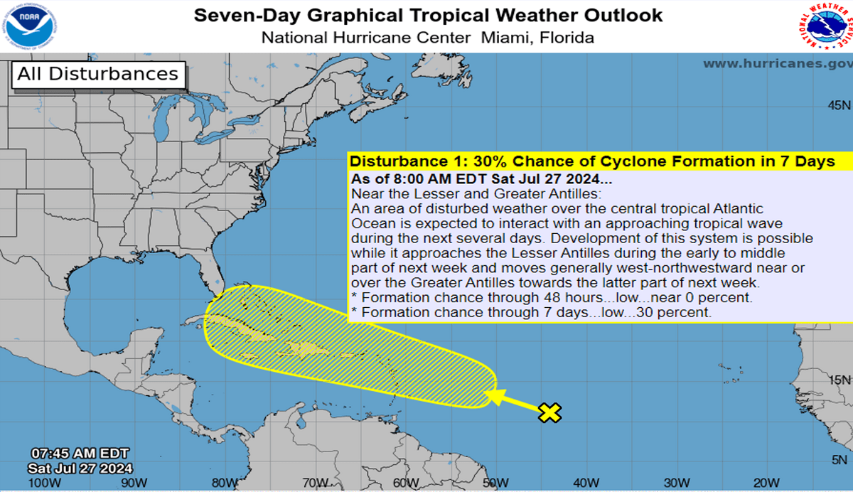
The 14-day storm tracks and ocean temperatures continue show the Bermuda High and Sahara Africa dust suppressing activity, but that is typical in July. The pattern looks to become more favorable for development in a couple weeks.

Severe Weather last week diminished a bit with 23 tornadoes, 231 hail events and 300 wind events. Tornadoes continue to rank the most in 13 years and in the top 3 of history while Hail cases are down -19% vs last year.

Last Week (21-27 July) across the World shows the U.S. getting a reprieve from the heat for some with national temperatures trending -2F cooler than last year, coolest in 5 years and 18th warmest of the past 39 years. The hot spot was the Northern Rockies and California while Texas to New England was on the cooler side. Rainfall was up +52% vs last year, wettest in 4 years and 9th wettest of the past 39 years.
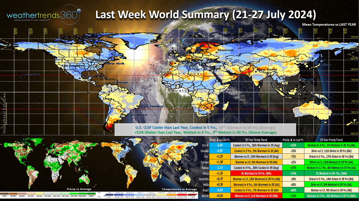
China was the hot spot trending #1 hottest and #1 wettest in 39 years with impacts from Typhoon Gaemi that hit the Philippines and Taiwan.
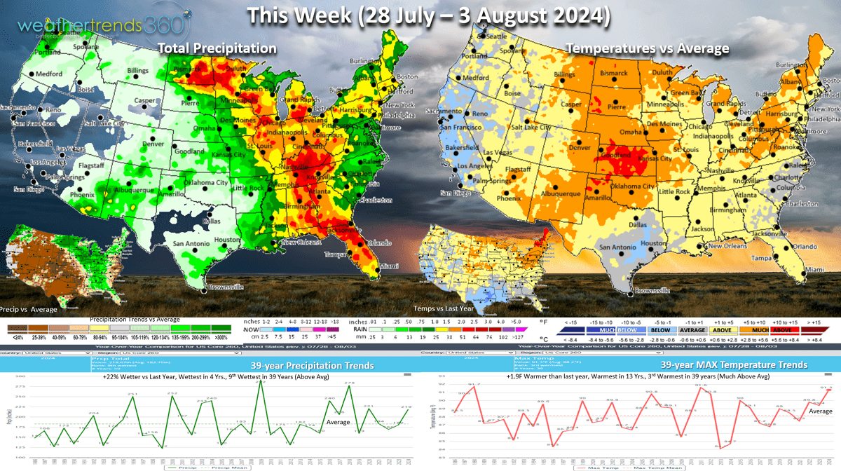
This week (28 Jul - 3 Aug) shows a warming trend with the heat moving back into the Central Plains and interior Northeast. Nothing compared to the June heat-waves but still has the U.S. trending +1.9F warmer than last year, warmest in 13 years and 3rd warmest of the past 39 years. Rainfall again up +22% vs last year, wettest in 4 years and 9th wettest of the past 39 years. Heaviest rain from Florida to Minnesota. Hot/wet weather is favorable for consumable food and beverage categories.
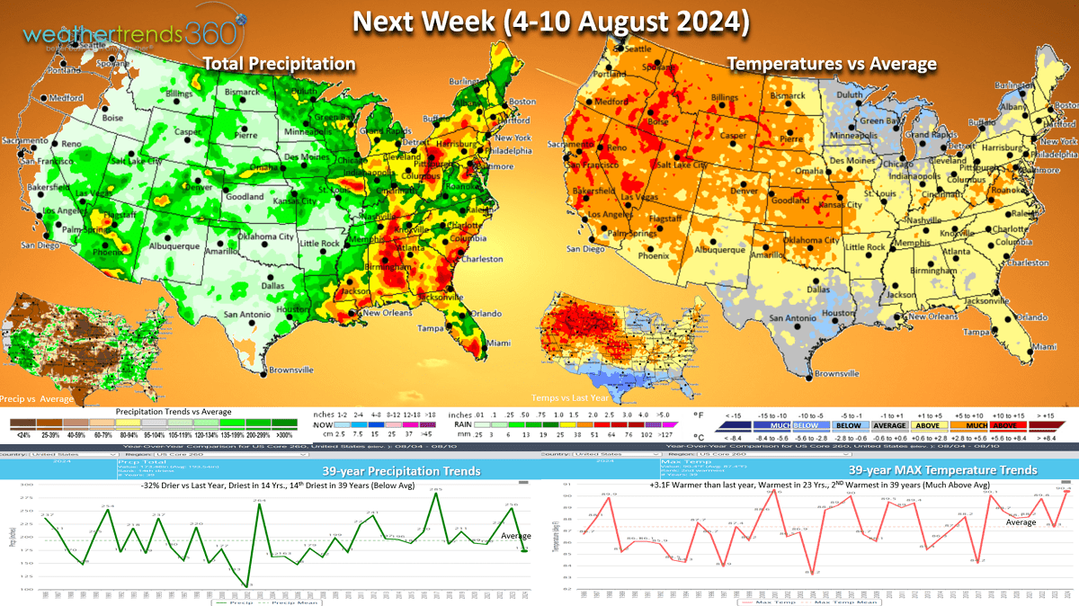
Next week (4-10 Aug) shows the heat expanding to the West while another cool front moves into the Great Lakes where there have been very few hot 90F days this year vs last year. U.S. temperatures look to trend +3.1F warmer than last year, warmest in 23 years and 2nd warmest of the past 39 years. Rainfall down -32% vs last year, least in 14 years and 14th driest of the past 39 years. The stormiest weather is in the East and more much needed rainfall for the drought areas of the Southeast.
The World 2-week outlook (28 Jul - 10 Aug) shows a generally warm pattern for most areas of the World. Australia (Winter), NE Siberia and Alaska look to have below average temperatures. Australia had the coolest Fall and front half of Winter in 12 years which in part explains why their Flu season is up +14% vs last year with mostly Type A cases and the most active many years. This is one predictor for the U.S. season ahead.
World 2-week Rainfall (28 Jul - 10 Aug) shows wet conditions for the Eastern half of the U.S. and dry West.
We hope you have a great week ahead, and don't forget to follow us on social media for frequent updates: Facebook, Twitter, YouTube, Pinterest and Linkedin.
- Captain Kirk out.