Captain's Log 25 Feb '23 Colder & Snowier Pattern into March
Captain's Log
25 February 2023 Happy Saturday! :) Only 4 days until Meteorological Spring, 23 days if you go by the Sun.
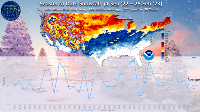
Despite the 3rd snowiest week of Winter, season-to-date snowfall is only +6% more than last year, -14% below average and 12th least of the past 38years. CLICK ON IMAGES FOR A LARGER VIEW.
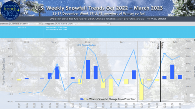
Week by week snowfall trends shows the middle December period remains the snowiest week of Winter. The outlook shows several snowier weeks in a row as we head into March which appears to be the coldest and snowiest in 4 years.
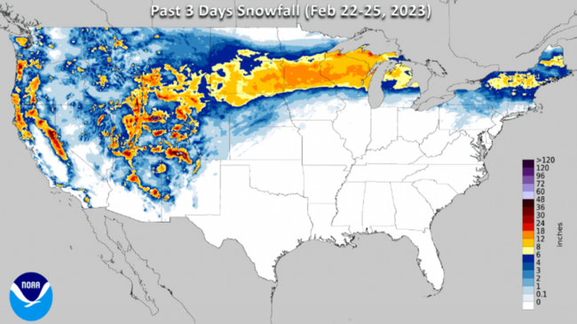
The big snow/ice storm this week brought heavy snow from the Rocky Mountains through the Upper Plains-Midwest and into New England. The Plains and Midwest were hard hit with snow and ice the past few days. Maps show the 72 hour snowfall totals from Wednesday morning to Saturday morning.
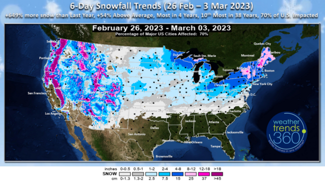
The next 6-days (26 Feb - 3 Mar) shows we'll add to these snow totals with +649% more snow than last year, +54% above average, most in 4 years and 10th most in 38 years. A fairly wide swath of snow coverage with 70% of U.S. getting some snow! A couple of snow threats for the Upper Midwest into the Northeast early and late in the week. The late week Friday storm could be the first accumulating even for the Philly to NYC corridor.
A recap of Last Week (19-25 Feb) around the World shows the U.S. trending +6.1F warmer than last year, 10th warmest of the past 38 years. Rainfall was down -15% vs last year and 18th driest of the past 38 years. Snowfall was finally way up +45% more than last year, most in 12 years and 6th most of the past 38 years. This was a strong week for snow accessories, a trend that will continue into March helping to clear out inventory.
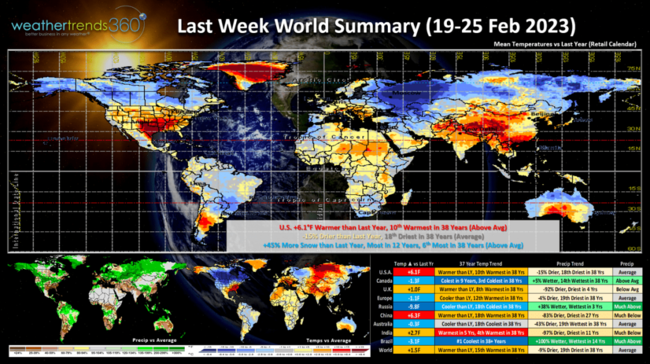
Canada was frigid trending the coldest in 9 years and 3rd coldest of the past 38 years. This is a negative for overall store traffic. Russia and Brazil were cold spots as well.
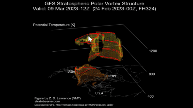
Just about the time we transition to meteorological Spring (starts 1 March) the Polar Vortex looks to disintegrate which makes the jet stream weaker and allows cold Arctic air to get displaced south. Some of that headed for the U.S. as we transition into March.
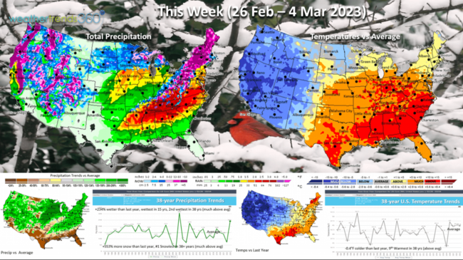
This Week (26 Feb - 4 Mar) shows the U.S. trending -0.4F colder than last year but still 9th warmest of the past 38 years. The strong ridge of High pressure in the Southeast continues to keep temperatures well above average. Grass and flowers are already emerging early from Texas to Virginia. This area will have the highest allergy and asthma suffering. The stormy pattern continues with rainfall up +234% over last year, wettest in 15 years and 2nd wettest in 38 years. Just the start as the U.S. drought gets wiped out with flooding and severe weather the major threats through Spring and Summer with the coolest and wettest conditions in 4 years nationally. Snowfall up a whopping +553% over last year which would make it the #1 snowiest start to March in over 38 years.
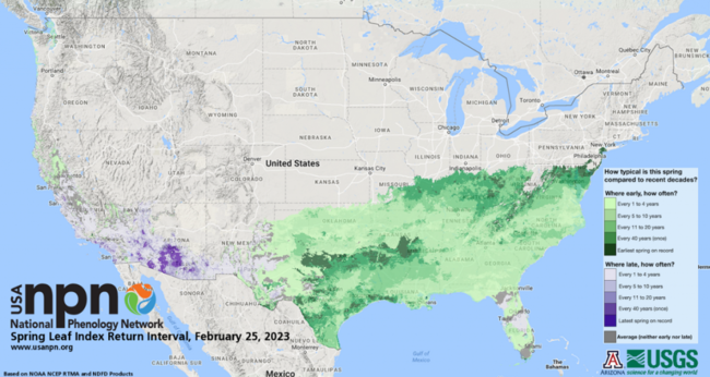
Unfortunately these very warm early temperatures in the Southeast have grass greening, leaves and flowers emerging. This poses some risk and this area is going to be susceptible to a killing frost/freeze in March. See NPN for more information on the early greening from Texas to Maryland.
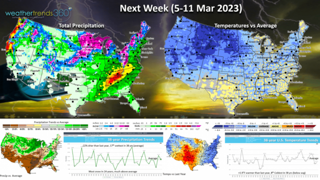
Next week (5-11 March) shows signs of the colder air invading much of the U.S. While temperatures trend +1.9F warmer than last year due to much warmer conditions in the South Central U.S. it's still 8th coldest of the past 38 years with below average temperatures for most. Rainfall down 22% vs last year but still 17th wettest in 38 years. Snowfall again appears to be heavy and the most in 24 years nationally. This week is also National Severe Weather Awareness week, good idea to have a plan in place for an active severe weather/tornado season. WT360 expects the worst season in 4 years!
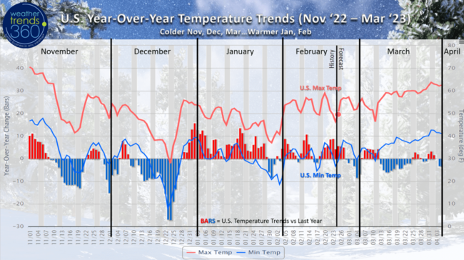
A recap of the daily year-over-year and national temperature trends shows the colder November-December followed by the much warmer January and February. The month ahead shows more colder days than warmers which is a negative for March retail and Spring seasonal sales.
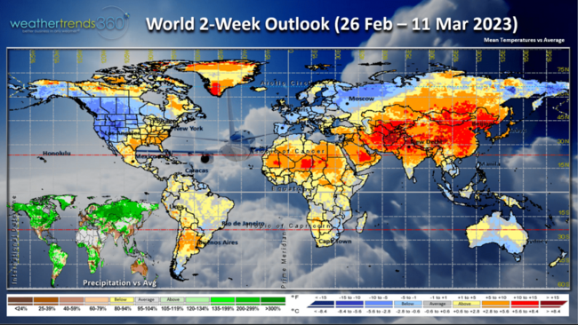
The 2-week World outlook (26 Feb - 11 Mar) is a bit misleading in the Eastern U.S. where it will be very mild but giving way too much cooler conditions in week 2. Europe and Southwest Russia remain the cold spots while it's exceptionally warm from Saudi Arabia to India into China.
We hope you have a great week, and don't forget to follow us on social media for frequent updates: Facebook, Twitter, YouTube, Pinterest and Linkedin.
- Captain Kirk out.