Captain's Log 24 Aug '24 Cool, Warm, Cool Volatile Pattern
Captain's Log
24 Aug 24: Happy Saturday! :)
https://www.youtube.com/watch?v=6Qp33CG55TY
TOP SECRET for now, but we had CNBC TV filming in our studio this past week...details coming soon. CLICK ON IMAGES FOR A LARGER VIEW

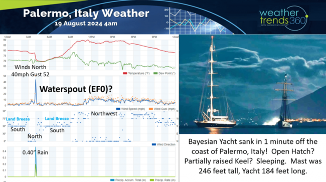
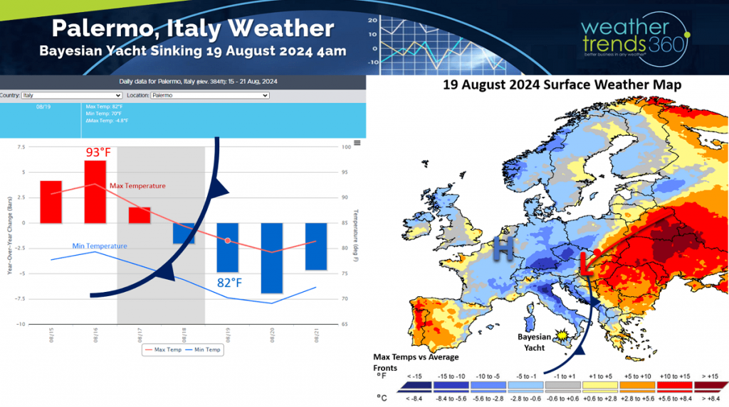
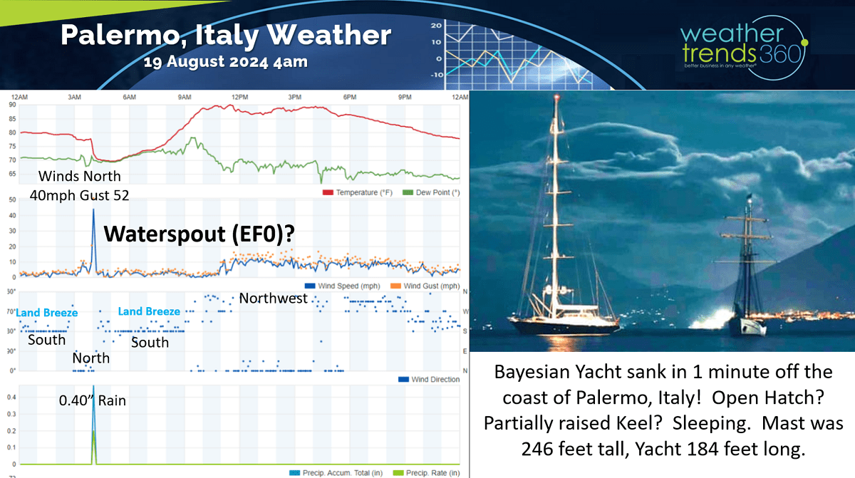
A quick weather analysis around the Bayesian Yacht sinking off Palermo, Italy. Sadly the weather clearly played a role. Eyewitness accounts suggest the yacht took a direct hit by a waterspout around 4am on the 19th of August.
The weather set up was certainly favorable for waterspout formation (these are not tornadoes and very narrow in width to the tune of dozens of feet vs tornadoes that can be a mile wide).
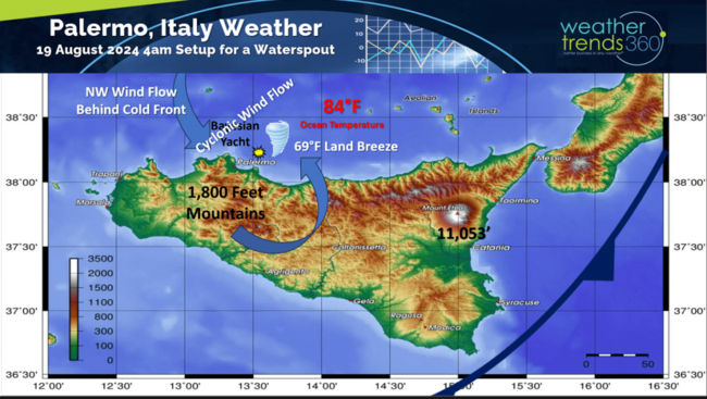
The higher terrain to the South of Palermo goes up to 1,800 feet in elevation which likely lead to a land-breeze coming off the Island from the South toward the yacht just off the coast. Data validates this southerly wind flow land-breeze. The predominant wind flow across the region was Northwesterly behind the cold front.
The ocean temperatures were 84F, about 5F above average with air temperatures around 69F for a 15-degree temperature contrast - ideal conditions for cyclonic like circulation that made it favorable for a waterspout to form. Waterspouts typically have wind speeds in the EFO range of the Enhanced Fujita scale in the 65-85mph range, enough to topple a sailboat with such a tall mast.
The nearest weather reporting station only reported Northerly winds of 42mph gusting to 50 mph for a very brief period at the time of the sinking and then shifted back to the southerly land-breeze until the mid-morning. The very tall mast of 246 feet and reports the keel was partially up were also contributing factors along with reports that a hatch was open allowing water to rush in with the yacht sinking very quickly, in about a minute. Prayers for all.
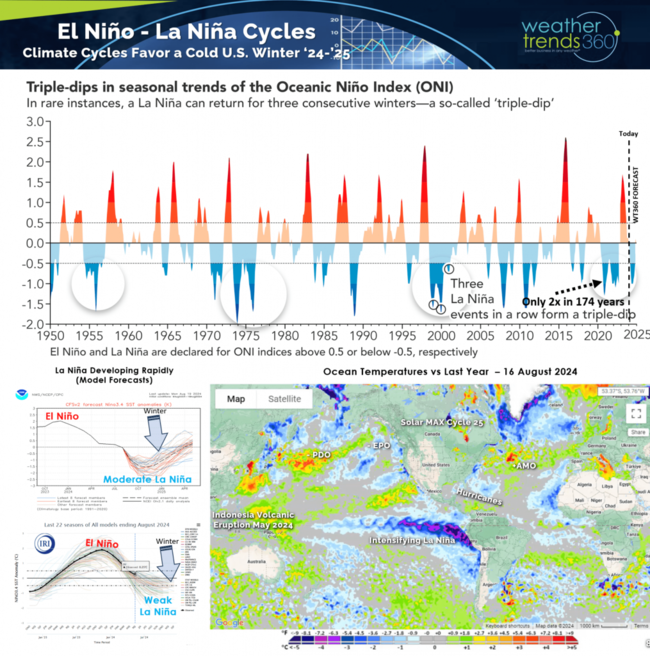
La Niña continues to develop with some atmospheric response starting to show up. wt360 expects this to be a short lived 6-month event playing a role this Winter before weakening to a Neutral phase by Spring 2025.

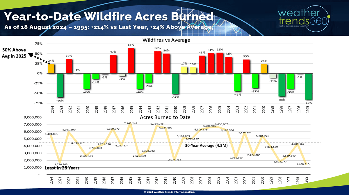
One response is increased wildfires in the U.S. after the least active season in 28 years last year. The next couple years look to have much above average wildfire acres burned in the Western U.S. Weather volatility will be high with an "out-of-sync" weather pattern for much of 2025 - not great news for retailers and seasonal suppliers along with increased risk for fires, drought and hurricanes as opposed to tornadoes, floods and hurricanes here in 2024.
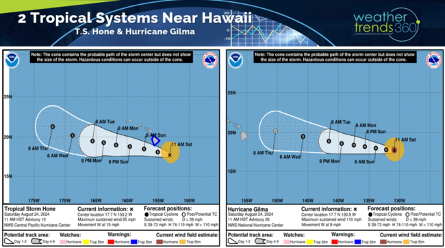
Hawaii is in the path of a couple tropical systems (Hone and Gilma) but hopefully a near miss to the South with Hone and to the North with Gilma.
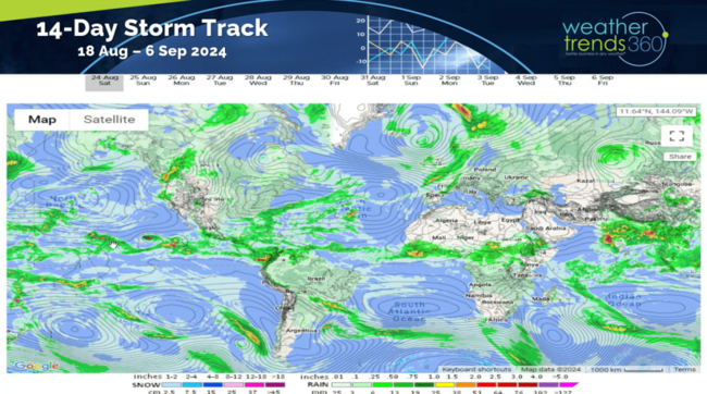
The 14-day storm tracks show very wet conditions across Equatorial Africa suggesting tropical waves coming off Africa will begin to increase as we enter the peak Sep - Oct period of the hurricane season.
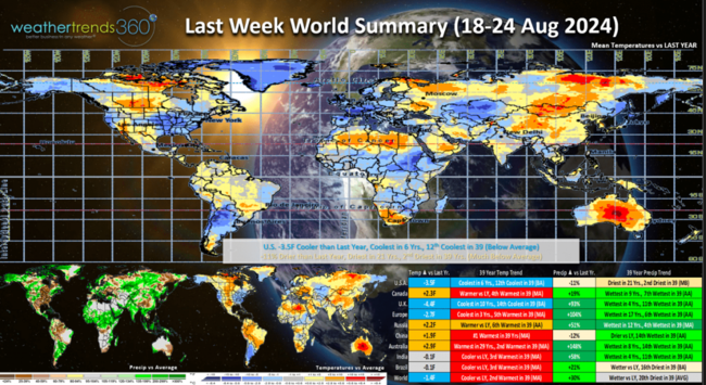
Last week (18-24 Aug) across the World shows the U.S. trending -3.5F cooler than last year, coolest in 6 years and 12th coolest in 39 years with below average temperatures especially in the East and West. Rainfall was down -11% vs LY, driest in 21 years and 2nd driest in 39. This time of year, cool and WET are favorable for Back2School apparel sales, so we had half the equation. The Northeast was the really cool spot with record low temperatures in the 30s and 40s just inland. The U.K. was the most favorable for early Fall categories across Europe.
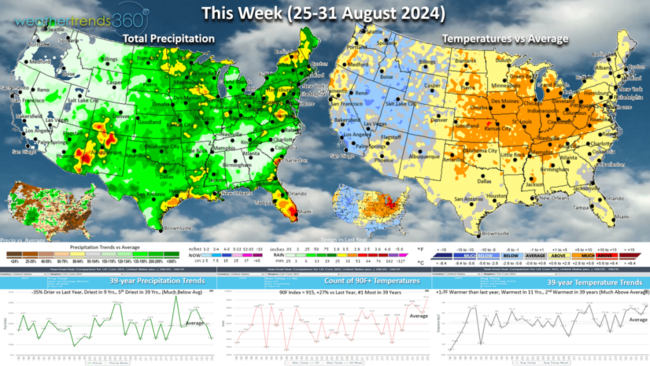
This week (25-31 Aug) shows more up and down volatility with a short lived big warm up in the Central and Eastern U.S. with national temperatures +1.7F warmer than last year, warmest in 11 years and 2nd warmest in 39 years. Rainfall -35% vs last year, driest in 9 years and 5th driest in 39 years. Warm and Dry are not ideal weather conditions this time of year with consumers maintaining a Summer mindset.
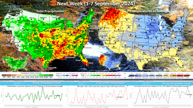
Next week (1-7 Sep) is the start of meteorological Fall and the weather looks to cooperate with a big cool down for the Central and Eastern U.S. National temperatures trend -2.1F cooler than last year, coolest in 7 years and 14th coolest in 39 years with below average national temperatures. Rainfall up +153% vs last year, most in 6 years and 9th most in 39 years. These are very favorable trends for early Fall and Back2School merchandise. The Northwest looks to be very hot and dry which is not favorable for seasonal category sales.
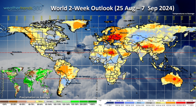
The World 2-week outlook (25 Aug - 7 Sep) is a bit misleading with an up and down weather pattern. Overall theme is unfavorable early Fall weather for the NW U.S. and Europe, especially Eastern Europe.

The heavier rainfall pattern across Africa is worrisome as we enter the core of the hurricane season. Wet soils will allow tropical waves to be more frequent across Africa as they head out into the main tropical development regions of the Atlantic Ocean basin.
Have a great week ahead, and don't forget to follow us on social media: Facebook, Twitter, YouTube, Pinterest and Linkedin.
- Captain Kirk out.
https://www.youtube.com/watch?v=6Qp33CG55TY
TOP SECRET for now, but we had CNBC TV filming in our studio this past week...details coming soon. CLICK ON IMAGES FOR A LARGER VIEW

A quick weather analysis around the Bayesian Yacht sinking off Palermo, Italy. Sadly the weather clearly played a role. Eyewitness accounts suggest the yacht took a direct hit by a waterspout around 4am on the 19th of August.
The weather set up was certainly favorable for waterspout formation (these are not tornadoes and very narrow in width to the tune of dozens of feet vs tornadoes that can be a mile wide).

The higher terrain to the South of Palermo goes up to 1,800 feet in elevation which likely lead to a land-breeze coming off the Island from the South toward the yacht just off the coast. Data validates this southerly wind flow land-breeze. The predominant wind flow across the region was Northwesterly behind the cold front.
The ocean temperatures were 84F, about 5F above average with air temperatures around 69F for a 15-degree temperature contrast - ideal conditions for cyclonic like circulation that made it favorable for a waterspout to form. Waterspouts typically have wind speeds in the EFO range of the Enhanced Fujita scale in the 65-85mph range, enough to topple a sailboat with such a tall mast.
The nearest weather reporting station only reported Northerly winds of 42mph gusting to 50 mph for a very brief period at the time of the sinking and then shifted back to the southerly land-breeze until the mid-morning. The very tall mast of 246 feet and reports the keel was partially up were also contributing factors along with reports that a hatch was open allowing water to rush in with the yacht sinking very quickly, in about a minute. Prayers for all.

La Niña continues to develop with some atmospheric response starting to show up. wt360 expects this to be a short lived 6-month event playing a role this Winter before weakening to a Neutral phase by Spring 2025.
One response is increased wildfires in the U.S. after the least active season in 28 years last year. The next couple years look to have much above average wildfire acres burned in the Western U.S. Weather volatility will be high with an "out-of-sync" weather pattern for much of 2025 - not great news for retailers and seasonal suppliers along with increased risk for fires, drought and hurricanes as opposed to tornadoes, floods and hurricanes here in 2024.

Hawaii is in the path of a couple tropical systems (Hone and Gilma) but hopefully a near miss to the South with Hone and to the North with Gilma.

The 14-day storm tracks show very wet conditions across Equatorial Africa suggesting tropical waves coming off Africa will begin to increase as we enter the peak Sep - Oct period of the hurricane season.
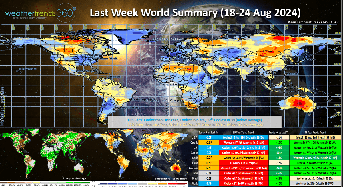
Last week (18-24 Aug) across the World shows the U.S. trending -3.5F cooler than last year, coolest in 6 years and 12th coolest in 39 years with below average temperatures especially in the East and West. Rainfall was down -11% vs LY, driest in 21 years and 2nd driest in 39. This time of year, cool and WET are favorable for Back2School apparel sales, so we had half the equation. The Northeast was the really cool spot with record low temperatures in the 30s and 40s just inland. The U.K. was the most favorable for early Fall categories across Europe.

This week (25-31 Aug) shows more up and down volatility with a short lived big warm up in the Central and Eastern U.S. with national temperatures +1.7F warmer than last year, warmest in 11 years and 2nd warmest in 39 years. Rainfall -35% vs last year, driest in 9 years and 5th driest in 39 years. Warm and Dry are not ideal weather conditions this time of year with consumers maintaining a Summer mindset.

Next week (1-7 Sep) is the start of meteorological Fall and the weather looks to cooperate with a big cool down for the Central and Eastern U.S. National temperatures trend -2.1F cooler than last year, coolest in 7 years and 14th coolest in 39 years with below average national temperatures. Rainfall up +153% vs last year, most in 6 years and 9th most in 39 years. These are very favorable trends for early Fall and Back2School merchandise. The Northwest looks to be very hot and dry which is not favorable for seasonal category sales.

The World 2-week outlook (25 Aug - 7 Sep) is a bit misleading with an up and down weather pattern. Overall theme is unfavorable early Fall weather for the NW U.S. and Europe, especially Eastern Europe.
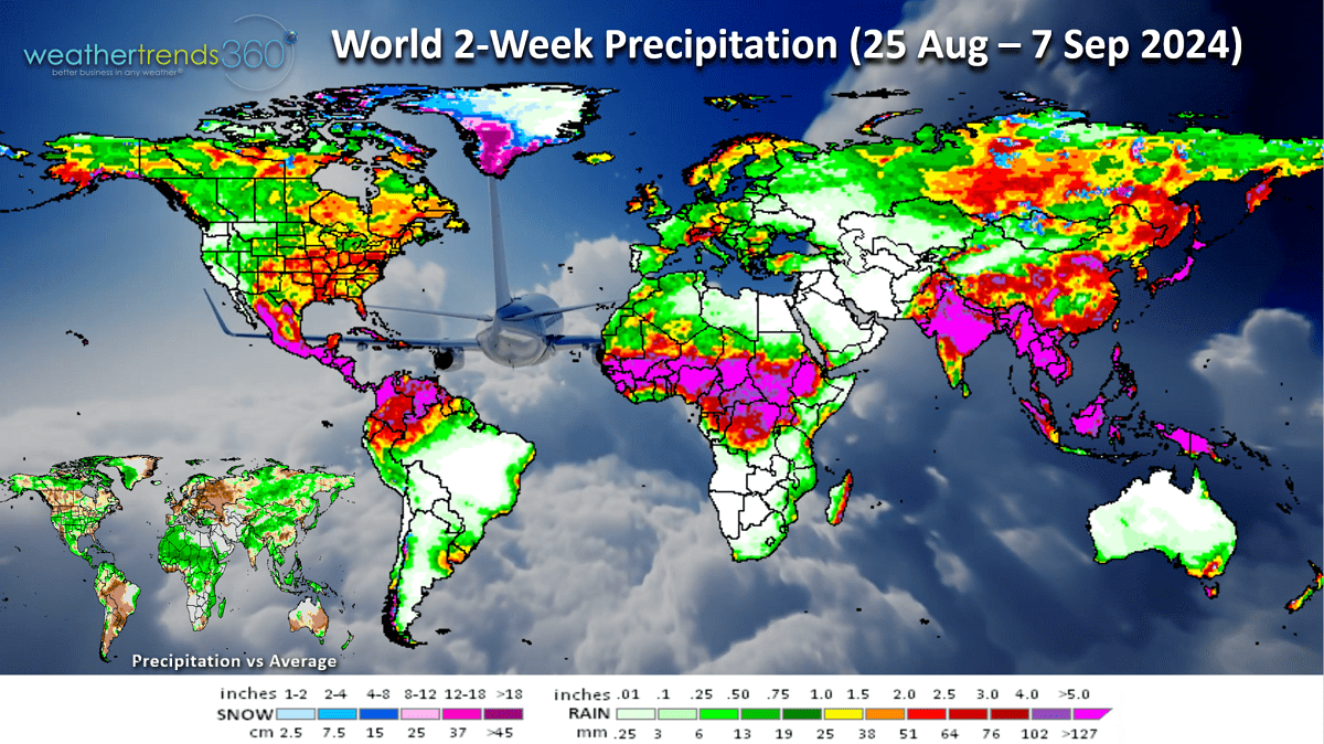
The heavier rainfall pattern across Africa is worrisome as we enter the core of the hurricane season. Wet soils will allow tropical waves to be more frequent across Africa as they head out into the main tropical development regions of the Atlantic Ocean basin.
Have a great week ahead, and don't forget to follow us on social media: Facebook, Twitter, YouTube, Pinterest and Linkedin.
- Captain Kirk out.