Captain's Log 23 Sep '23 Out-of-Sync Warm/Dry Pattern
Captain's Log
23 Sep '23: Happy First Saturday of Fall! :)
Fall officially arrived this morning at 2:50am EDT as did Tropical Storm Ophelia. CLICK ON IMAGES FOR A LARGER VIEW.

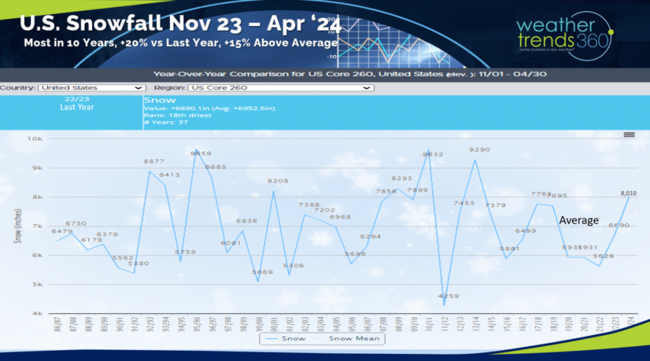
So, let's talk SNOW...for the U.S. overall WTI expects snowfall for the late Fall into early Spring 2024 period to be the most in 10 years, +20% more than last year and +15% above average with an active Midwest and Nor'easter pattern. That's all we have to say about that for now. :)
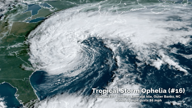
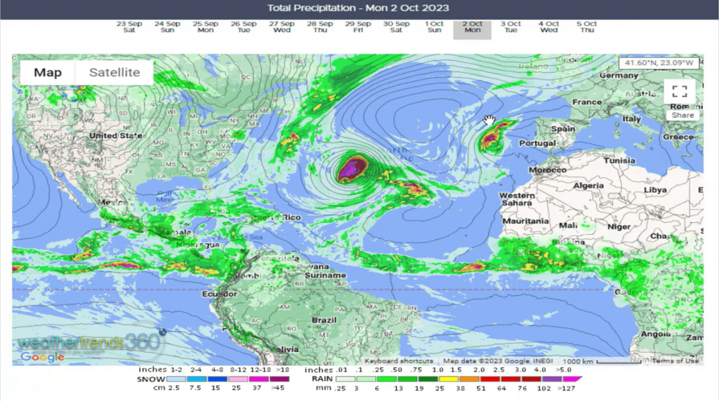
Tropical Storm Ophelia was just a hair below hurricane strength at landfall this morning 6:15am EDT near Emerald Isle North Carolina. Winds at landfall were sustained 69mph gusting to 86 mph per the National Hurricane Center. Now just a big rainstorm likely to cause some inland flooding from NC to MD.
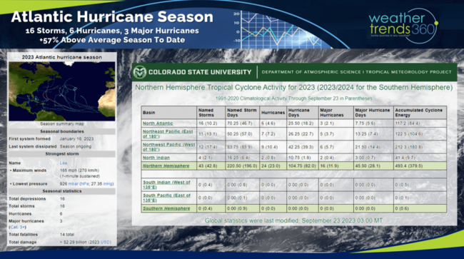
This was the 16th system of the 2023 Atlantic Hurricane season which is +57% above average for this point in the season. A bit unusual that a developing strong El Nino year would have the Atlantic basin the most active around the World. The systems coming off Africa are creating a parade of storms and #17 Philippe likely this weekend.
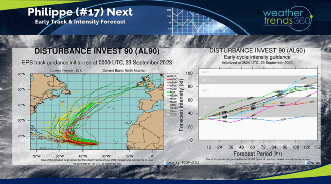
For now, Philippe appears it will become a stronger hurricane but most likely making a right turn into the Central Atlantic - TBD.
There are more tropical waves coming off Africa, so the active pattern is likely to continue into October.
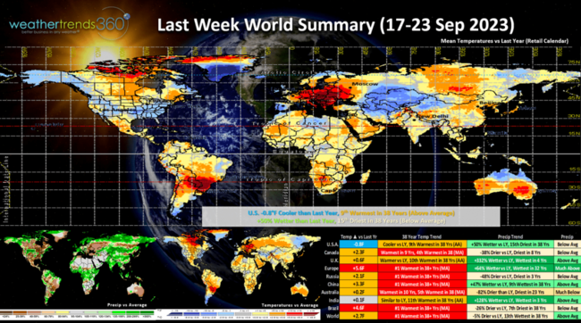
 Last week (17-23 Sep) across the World shows the U.S. trending -0.8F cooler than last year but still 9th warmest of the past 38 years. Rainfall was up +50% vs last year but still 15th driest of the past 38 years. These are slightly favorable trends for early Fall merchandise sales with the Southeast the most favored region. Can't say that for the rest of the World that showed very warm conditions with many areas like Europe, Russia, China and Brazil all showing the hottest conditions in over 38 years.
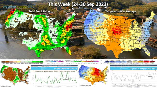
This week (24-30 Sep) the West and East Coast are the cooler spots with very warm weather for the Central U.S. Nationally temperatures are +3.7F warmer than last year making it the 3rd warmest in 38 years for the U.S. overall. A moderately unfavorable trend for Fall seasonal sales. Rainfall -37% vs last year, least in 15 years and 9th least in 38 years with the heavy Ophelia rains in the Northeast and some heavier rain in the Northwest. Cooler and Wetter YOY weather trends are the most ideal for seasonal sales.
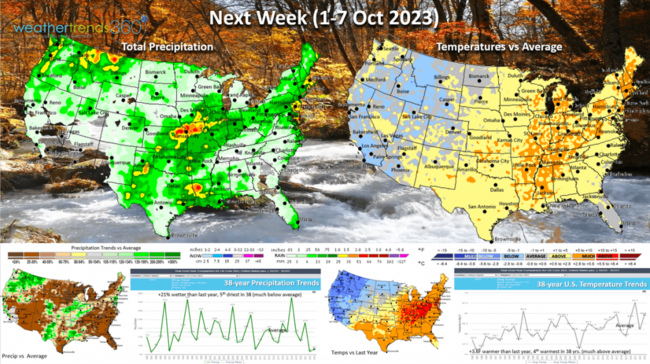
Next week (1-7 Oct) shows more of the same with expanding warm weather in the East. For the U.S. overall the week looks to trend +3.6F warmer than last year and 4th warmest of the past 38 years. The cooler spots are in the Rockies. Rainfall up +21% vs a year ago, but still 5th driest of the past 38 years.
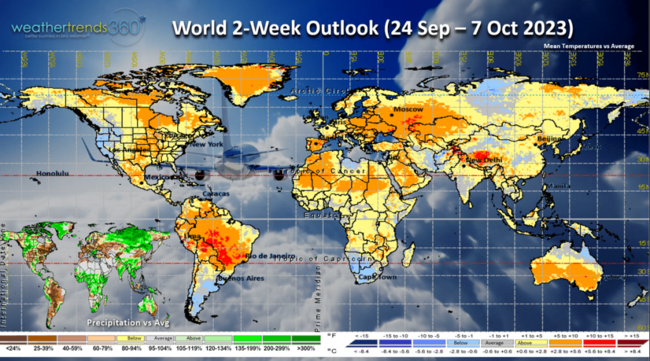
The World 2-week outlook (24 Sep - 7 Oct) shows very few favorable areas for Fall seasonal sales with the Western U.S. one of the few bright spots.
Have a great week ahead. Don't forget to follow us on social media for frequent updates: Facebook, Twitter, YouTube, Pinterest and Linkedin.
- Captain Kirk out
Fall officially arrived this morning at 2:50am EDT as did Tropical Storm Ophelia. CLICK ON IMAGES FOR A LARGER VIEW.

So, let's talk SNOW...for the U.S. overall WTI expects snowfall for the late Fall into early Spring 2024 period to be the most in 10 years, +20% more than last year and +15% above average with an active Midwest and Nor'easter pattern. That's all we have to say about that for now. :)

Tropical Storm Ophelia was just a hair below hurricane strength at landfall this morning 6:15am EDT near Emerald Isle North Carolina. Winds at landfall were sustained 69mph gusting to 86 mph per the National Hurricane Center. Now just a big rainstorm likely to cause some inland flooding from NC to MD.

This was the 16th system of the 2023 Atlantic Hurricane season which is +57% above average for this point in the season. A bit unusual that a developing strong El Nino year would have the Atlantic basin the most active around the World. The systems coming off Africa are creating a parade of storms and #17 Philippe likely this weekend.

For now, Philippe appears it will become a stronger hurricane but most likely making a right turn into the Central Atlantic - TBD.

There are more tropical waves coming off Africa, so the active pattern is likely to continue into October.
 Last week (17-23 Sep) across the World shows the U.S. trending -0.8F cooler than last year but still 9th warmest of the past 38 years. Rainfall was up +50% vs last year but still 15th driest of the past 38 years. These are slightly favorable trends for early Fall merchandise sales with the Southeast the most favored region. Can't say that for the rest of the World that showed very warm conditions with many areas like Europe, Russia, China and Brazil all showing the hottest conditions in over 38 years.
This week (24-30 Sep) the West and East Coast are the cooler spots with very warm weather for the Central U.S. Nationally temperatures are +3.7F warmer than last year making it the 3rd warmest in 38 years for the U.S. overall. A moderately unfavorable trend for Fall seasonal sales. Rainfall -37% vs last year, least in 15 years and 9th least in 38 years with the heavy Ophelia rains in the Northeast and some heavier rain in the Northwest. Cooler and Wetter YOY weather trends are the most ideal for seasonal sales.

Next week (1-7 Oct) shows more of the same with expanding warm weather in the East. For the U.S. overall the week looks to trend +3.6F warmer than last year and 4th warmest of the past 38 years. The cooler spots are in the Rockies. Rainfall up +21% vs a year ago, but still 5th driest of the past 38 years.

The World 2-week outlook (24 Sep - 7 Oct) shows very few favorable areas for Fall seasonal sales with the Western U.S. one of the few bright spots.

Have a great week ahead. Don't forget to follow us on social media for frequent updates: Facebook, Twitter, YouTube, Pinterest and Linkedin.
- Captain Kirk out