Captain's Log 22 Jun '24 Favorable Warmer/Drier for Seasonal Sales
Captain's Log
22 June 2024: Happy Saturday! :)
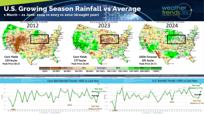
Season-to-date Rainfall since 1 March shows a dramatically wetter pattern than last year. Last year was the driest in 11 years for the U.S. overall and driest in 35 years across the U.S. Corn Belt, not this year! This year is trending the wettest in 5 years for the U.S. and Corn Belt. Some hype that this year was going to be 2012, 1988 extreme drought years - not happening. CLICK ON IMAGES FOR A LARGER VIEW
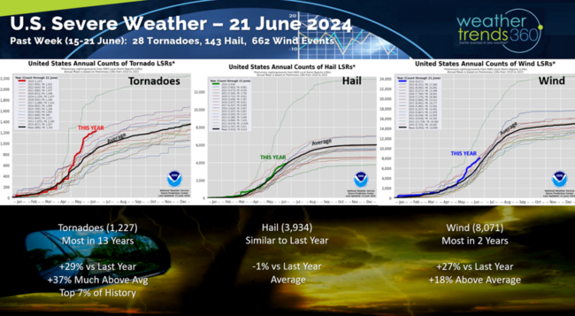
Severe weather slowed a bit last week with 28 tornadoes, 143 hail events and 662 wind events reported. Tornadoes are still trending the most in 13 years and in the top 7% of history.
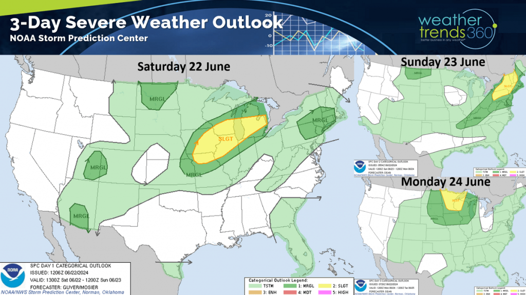
The severe weather threats remain across the Midwest, Great Lakes and New England this week.
 The seasons first Tropical Storm Alberto moved into Northern Mexico Friday but still brought 4-6" flooding rains to Coastal Texas.
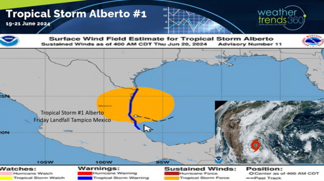
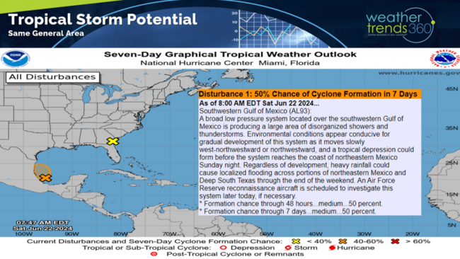
One more threat for this same general area of Mexico before a lull in tropical activity.
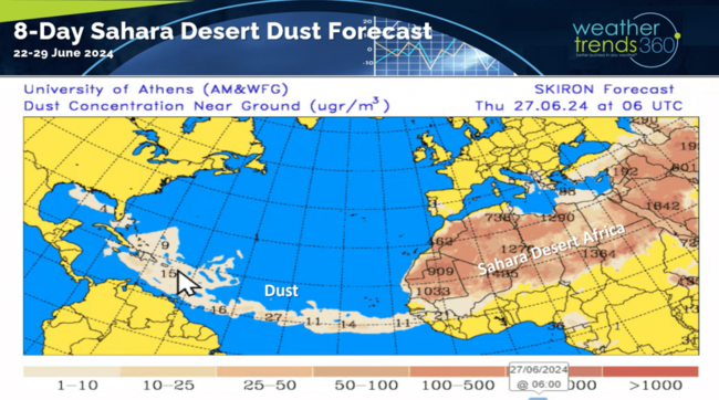
One reason for the lull is some dust coming off the Sahara Desert in Africa traversing the tropical Atlantic toward the Southeast U.S.
Last week (16-22 June) across the World shows the U.S. trending +4.1F warmer than last year, warmest in 30 years and 3rd warmest of the past 39 years. Rainfall down -8% vs last year and 18th driest of the past 39 years (near average). These were very favorable trends for hot seasonal categories like cold beverages, AC, fans, pool chemicals, water toys, etc.
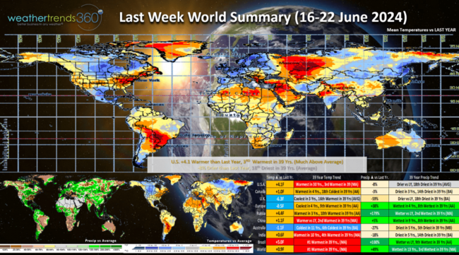
It remained much cooler across Northern Europe and the U.K. which tends to lower demand for Summer seasonal category sales.
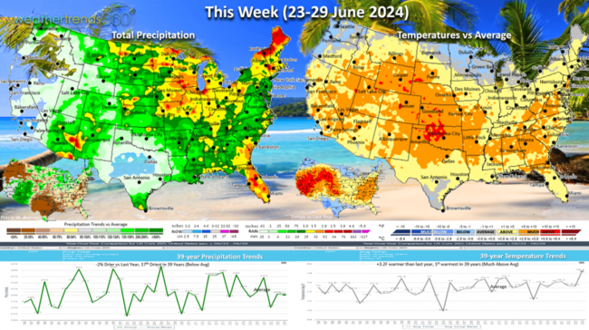
This week (23-29 June) shows a cooling trend for the Upper Plains into the Northeast with the hot weather shifting to the South-Central Plains. The U.S. overall trends +3.2F warmer than last year making it the #1 hottest in over 39 years. A solid 1-2" of rain across most of the U.S. Corn Belt, Midwest and Northeast as a couple cold fronts end the heat-wave. National rainfall down -2% vs last year and 17th driest of the past 39 years. Warmer/Drier year-over-year weather is the most ideal category for Summer seasonal sales.
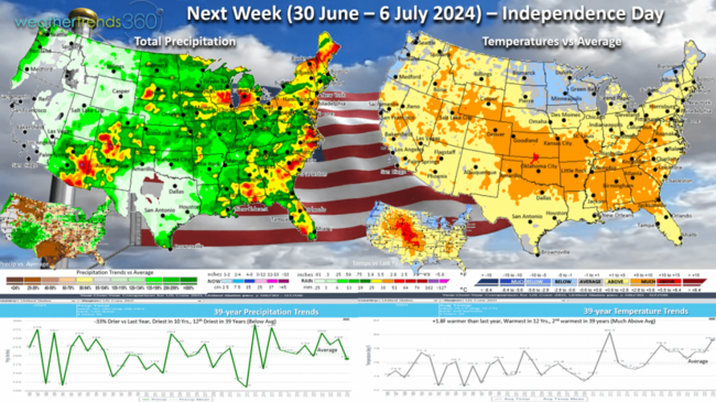
Next week (30 June - 6 July) shows the heat remaining in the Central U.S. to the Southeast with less extreme conditions in the Upper Midwest to the Northeast. The U.S. overall trends +1.8F warmer than last year, warmest in 12 years and 2nd warmest of the past 39 years. Consumable categories like cold beverages, picnic categories and pool supplies should remain favorable for the 4th of July Independence Day holiday. Some softening of demand in the Great Lakes - Northeast and Pacific Northwest.
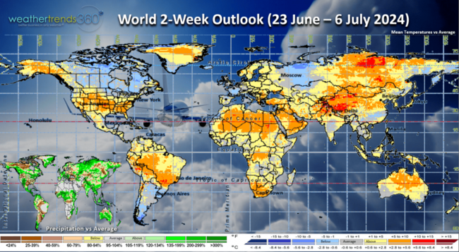
The World 2-week outlook (23 June - 6 July) shows the cooler trends across Canada and the Northern tier of the U.S.
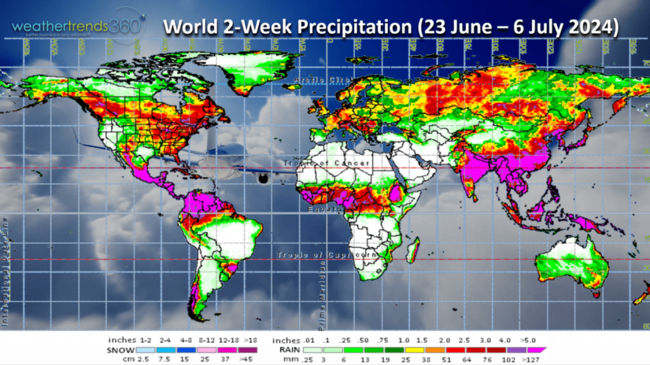
World 2-week rainfall (23 June - 6 July) shows moderate rainfall in the U.S. Midwest and Eastern half of the country. Much needed rainfall across Mexico as tropical moisture continues to bring heavier rain.
Have a great week, and don't forget to follow us on social media for frequent updates: Facebook, Twitter, YouTube, Pinterest and Linkedin.
- Captain Kirk out.
Season-to-date Rainfall since 1 March shows a dramatically wetter pattern than last year. Last year was the driest in 11 years for the U.S. overall and driest in 35 years across the U.S. Corn Belt, not this year! This year is trending the wettest in 5 years for the U.S. and Corn Belt. Some hype that this year was going to be 2012, 1988 extreme drought years - not happening. CLICK ON IMAGES FOR A LARGER VIEW

Severe weather slowed a bit last week with 28 tornadoes, 143 hail events and 662 wind events reported. Tornadoes are still trending the most in 13 years and in the top 7% of history.

The severe weather threats remain across the Midwest, Great Lakes and New England this week.
 The seasons first Tropical Storm Alberto moved into Northern Mexico Friday but still brought 4-6" flooding rains to Coastal Texas.
One more threat for this same general area of Mexico before a lull in tropical activity.

One reason for the lull is some dust coming off the Sahara Desert in Africa traversing the tropical Atlantic toward the Southeast U.S.

Last week (16-22 June) across the World shows the U.S. trending +4.1F warmer than last year, warmest in 30 years and 3rd warmest of the past 39 years. Rainfall down -8% vs last year and 18th driest of the past 39 years (near average). These were very favorable trends for hot seasonal categories like cold beverages, AC, fans, pool chemicals, water toys, etc.

It remained much cooler across Northern Europe and the U.K. which tends to lower demand for Summer seasonal category sales.

This week (23-29 June) shows a cooling trend for the Upper Plains into the Northeast with the hot weather shifting to the South-Central Plains. The U.S. overall trends +3.2F warmer than last year making it the #1 hottest in over 39 years. A solid 1-2" of rain across most of the U.S. Corn Belt, Midwest and Northeast as a couple cold fronts end the heat-wave. National rainfall down -2% vs last year and 17th driest of the past 39 years. Warmer/Drier year-over-year weather is the most ideal category for Summer seasonal sales.

Next week (30 June - 6 July) shows the heat remaining in the Central U.S. to the Southeast with less extreme conditions in the Upper Midwest to the Northeast. The U.S. overall trends +1.8F warmer than last year, warmest in 12 years and 2nd warmest of the past 39 years. Consumable categories like cold beverages, picnic categories and pool supplies should remain favorable for the 4th of July Independence Day holiday. Some softening of demand in the Great Lakes - Northeast and Pacific Northwest.

The World 2-week outlook (23 June - 6 July) shows the cooler trends across Canada and the Northern tier of the U.S.

World 2-week rainfall (23 June - 6 July) shows moderate rainfall in the U.S. Midwest and Eastern half of the country. Much needed rainfall across Mexico as tropical moisture continues to bring heavier rain.
Have a great week, and don't forget to follow us on social media for frequent updates: Facebook, Twitter, YouTube, Pinterest and Linkedin.
- Captain Kirk out.