Captain's Log 20 Feb '22 Stormy Week & Cold Start to March
Captain's Log
Happy Sunday! :)
A recap of last week around the World shows the U.S. trending +12.2F warmer than a year ago when the Polar Vortex was still plaguing the U.S., but still 16th coldest of the past 37 years with below average national temperatures. CLICK ON IMAGES FOR A LARGER VIEW.
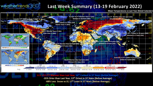
These warmer trends were a negative for winter seasonal merchandise that did exceptionally well a year ago February. Rainfall was 35% less than last year and 13th driest of the past 37 years (below average) while Snowfall was also 68% less than a year ago and 17th least of the past 37 years (below average).
The colder spots across the World compared to last year were in the U.K., Australia, India and especially China. Warmer spots were Europe and especially Western Russia.
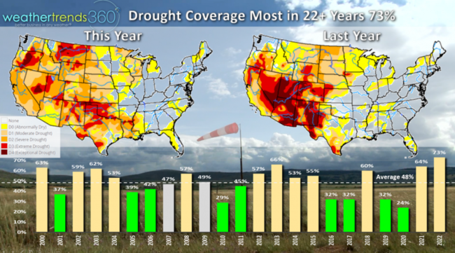
With two major Pacific Ocean cycles entrenched in a long-term cold phase (PDO and La Nina), drought continues to be a concern across the U.S. with 73% of the U.S. in dry to drought phases, the most in over 22 years. Some relief this week with a stormier pattern.
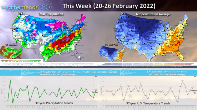
This Week (20-26 Feb) shows a more widespread shot of very cold air invading the U.S. with a glancing shot of the Polar Vortex. The U.S. will trend -5.7F colder than last year, coldest in 3 years and 11th coldest of the past 37 years with below average national temperatures. This will be a stronger week for Winter seasonal merchandise on clearance. Rainfall up +94% over last year, most in 4 years and 11th wettest of the past 37 years. Snowfall also way up, the most in 11 years as another strong storm systems moves into the Central and Eastern U.S.
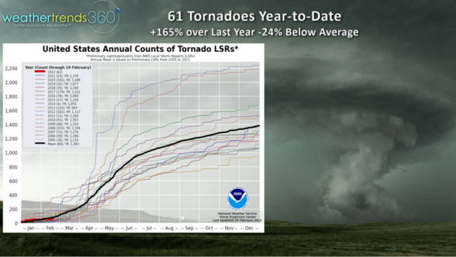
Severe weather and tornadoes are possible this week in the Southeastern U.S. ahead of this front with a big warm surge bring 60F temperatures well into the Northeast mid-week but plummeting temps in the Midwest. A catalyst for sever weather across this front. Year-to-date tornadoes are up 165% over last year with 61 so far, we'll add to that this week and especially in March and April which should be much more active than last year's below average Spring.
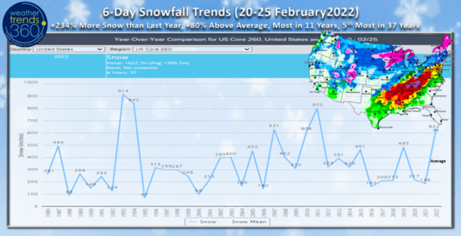
The 6-day snowfall trends show the snowiest late February period in 11 years with +234% more snow than this time last year and 80% above average.
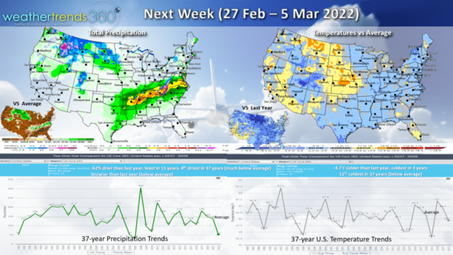
Next Week (27 Feb - 5 Mar) will continue to up and down temperature wise, but the nation overall trends 4.7F colder than last year, coldest in 3 years and 11th coldest of the past 37 years. A drier week trending down 62% vs last year and least in 15 years but snowfall will be more than a year ago (below average). The colder trends are likely to continue through most of March into the front half of April. Middle April and the Easter period look to be the lone bright spot of Q1 for retailers and Spring seasonal categories.
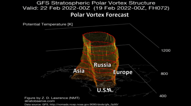
The Polar Vortex has been strong this Winter which typically keeps it bottled up at the North Pole, but the Great Lakes to Northeast have been one areas getting more frequent glancing shots of the PV with 2022 year-to-date trending the coldest in 7 years after the very warm December.
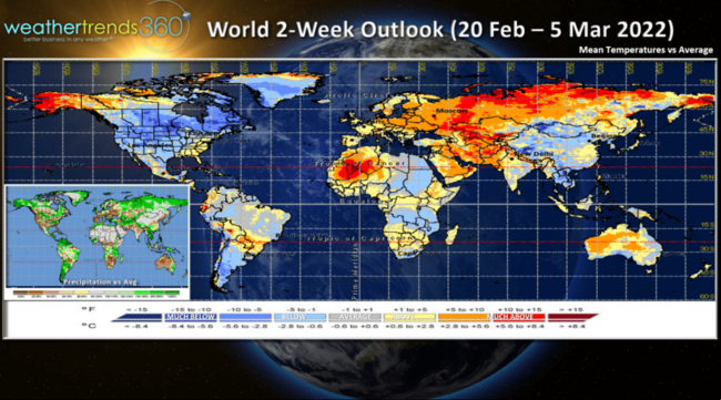
The 2-week (20 Feb - 5 Mar) World outlook shows the colder weather camped out over North America while Europe, Russia, Middle East and Siberia are well above average.
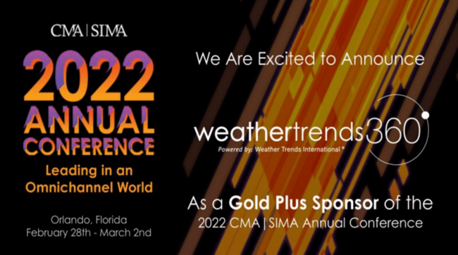
Team wt360 is proud to be a gold sponsor for the Category Management Association's 2022 Annual Conference in Orland0, Florida Feb 28th - Mar 2nd. We'll talk about how we help larger retailers and seasonal suppliers plan how much inventory to buy or make, where to allocate more or less, when to promote and advertise a YEAR-AHEAD!

Check out today's video with a timelapse of an intense snow squall that moved through our headquarters here in Bethlehem PA Saturday. You can view our panoramic 360 degree roof top weather camera's live anytime.
Have a great week and don't forget to follow us on social media: Facebook, Twitter, YouTube, Pinterest and Linkedin.
- Captain Kirk out.