Captain's Log 19 Oct '24 Warmer/Drier Pattern Ahead
Captain's Log
19 Oct 24: Happy Saturday. :)
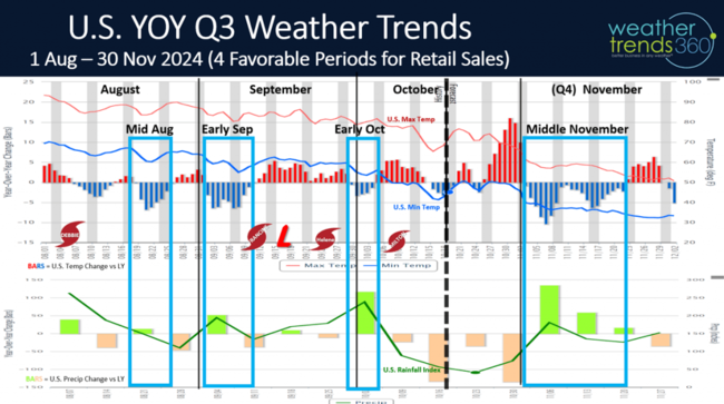
Q3 (Aug - Oct) is just about in the history books with three stronger periods (cooler and wetter) for seasonal sales in middle August, early September and early October. The next stronger sales period likely in Middle November. CLICK ON IMAGES FOR A LARGER VIEW.
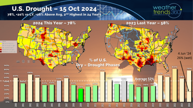
Drought has made a huge comeback after dipping to just 26% of the country dry to drought conditions back on 4 June to 78% as of middle October. This is +20% more widespread than last year, +26% above average (dry) and 2nd greatest coverage in 24 years. The driest Sept-Oct in decades for the U.S. overall resulted in expanding drought.
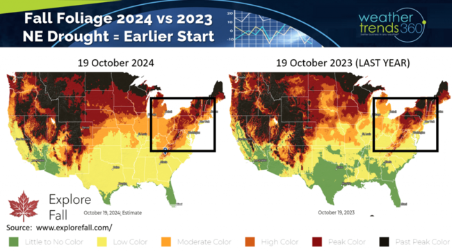
The dry Fall has fall color peaking a week or two early in the Great Lakes and Northeast.
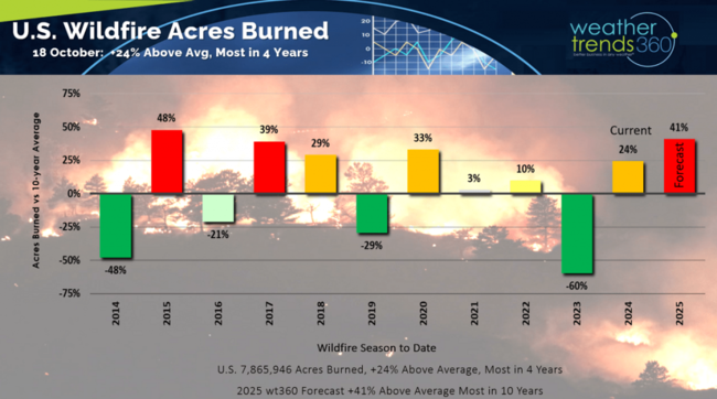
Wildfire acres burned now stands at 7.86 million acres burned which is +24% above average and the most in 4 years. WTI expects this to surge to 10-year highs in 2025 with an even more active wildfire season.
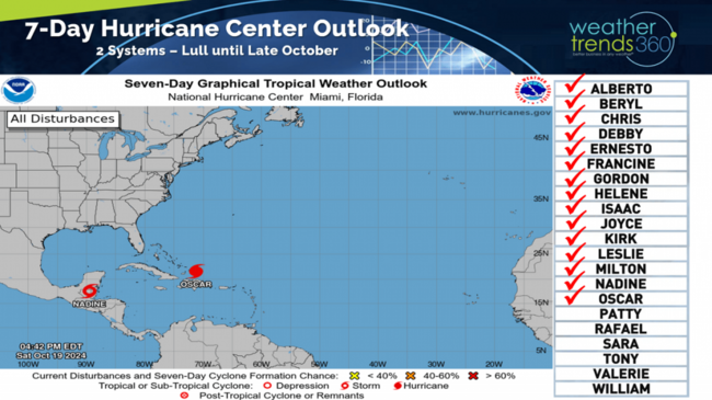
Two more tropical systems developed (T.S. Nadine in Mexico and Hurricane Oscar near Haiti). Neither poses a risk to the U.S.
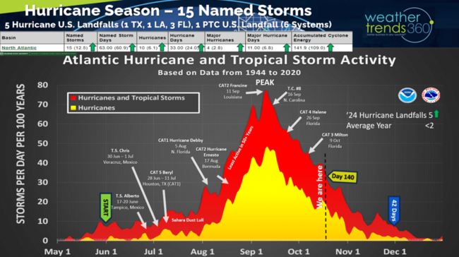
Season to date shows all hurricane season metrics are now well above average with 15 named storms (16 systems) and 5 landfalling hurricanes in the U.S., well above the average of 2. There are still 42 days left in the season with a lull likely for the next 7-10 days but then a more favorable MJO cycle returning for late October into November.
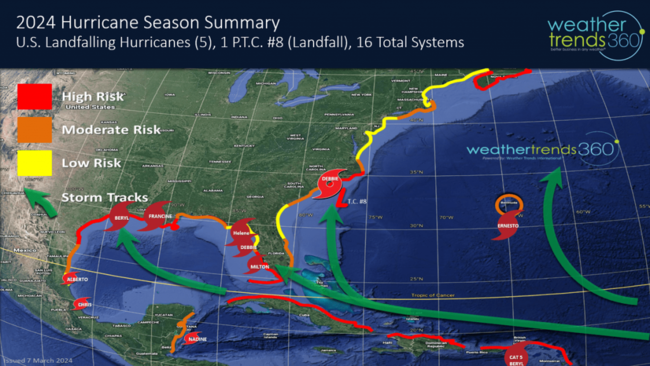
The hurricane season summary shows 5 U.S. landfalling hurricanes and 1 Potential Tropical Cyclone landfall (6 total).
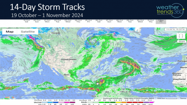
The 14-day storm track shows the potential for a lull and then a couple systems developing in late October.
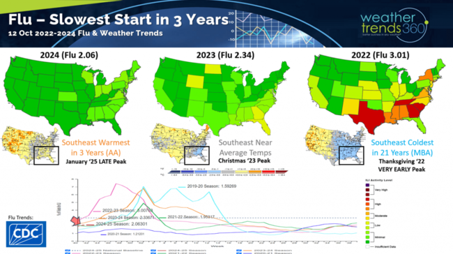
With the warmer/drier Fall, Flu is at 3-year lows and dramatically less than the very fast start in 2022 when Flu peaked at Thanksgiving. Last year peaked after Christmas and this year is likely to be in middle January. So goes the weather in the Southeast U.S., so goes the start of the Flu season.
Last week (13-19 Oct) across the World shows the U.S. having a partially favorable week for seasonal sales with temperatures trending -0.8F colder than last year and 16th coldest of the past 39 years with below average national temperatures. The Eastern half of the U.S. was the most favorable for seasonal sales with the coldest middle October week in 15 years. Rainfall was -44% less than last year, driest in 9 years and 3rd driest of the past 39 years. This time of year, colder/wetter conditions are typically more favorable for seasonal and retail sales.
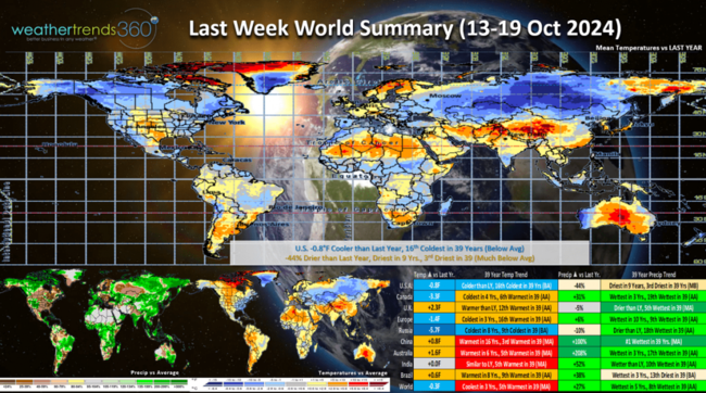
Russia was cool, wet and snowy with well above average snowfall across Siberia. Heavy early snow in Siberia is one statistical cycle that helps bring colder/snowier weather to the Eastern half of North America during the Winter.
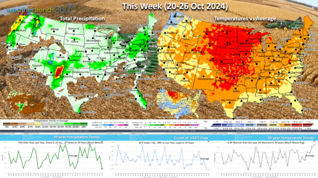
This week (20-26 Oct) shows a return to a warm and dry pattern with the U.S. trending +1F warmer than last year and #1 warmest in 39 years. Rainfall is down -75% vs last year, the least in 11 years and 2nd least in 39 years. These are great conditions for farmers harvesting corn and soybeans rapidly drying out.
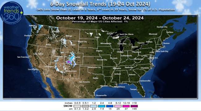
Some snow in the higher elevations of the Rockies with flooding risk in New Mexico.
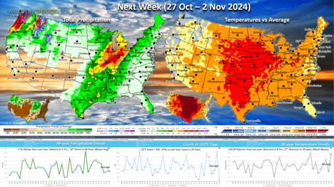
Next Week (27 Oct - 2 Nov) is the end of the retail Q3 with the U.S. trending a significant +10.9F warmer than last year, warmest in 8 years and 2nd warmest in 39 years. Rainfall up +7% vs last year, the wettest in 3 years but still 16th driest of the past 39 years nationally. The trends are not favorable for seasonal sales after a strong week a year ago.
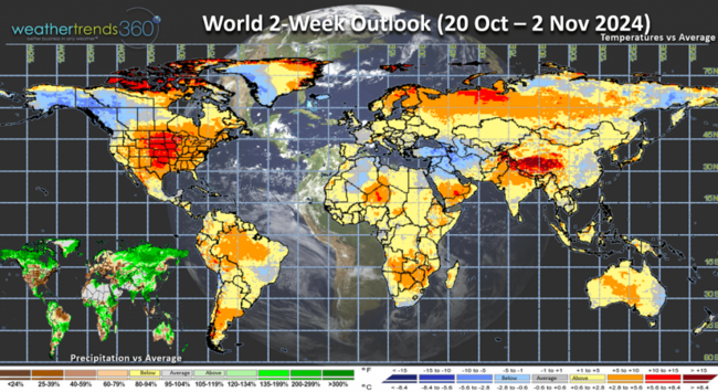
The World 2-week outlook (20 Oct - 2 Nov) shows Alaska, Western Canada and the Middle East as the few favorable areas for stronger seasonal sales. More rain for the Southern half of Brazil is favorable for their Full Season crops being planted.
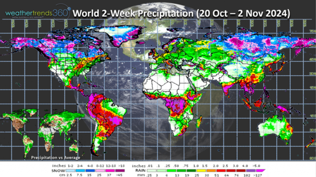
The World 2-week Precipitation outlook shows the heavy snow across Siberia and expanding across Alaska and Northern Canada.
Have a great week ahead, and don't forget to follow us on social media for frequent updates: Facebook, Twitter, YouTube, Pinterest and Linkedin.
- Captain Kirk out
Q3 (Aug - Oct) is just about in the history books with three stronger periods (cooler and wetter) for seasonal sales in middle August, early September and early October. The next stronger sales period likely in Middle November. CLICK ON IMAGES FOR A LARGER VIEW.

Drought has made a huge comeback after dipping to just 26% of the country dry to drought conditions back on 4 June to 78% as of middle October. This is +20% more widespread than last year, +26% above average (dry) and 2nd greatest coverage in 24 years. The driest Sept-Oct in decades for the U.S. overall resulted in expanding drought.

The dry Fall has fall color peaking a week or two early in the Great Lakes and Northeast.

Wildfire acres burned now stands at 7.86 million acres burned which is +24% above average and the most in 4 years. WTI expects this to surge to 10-year highs in 2025 with an even more active wildfire season.

Two more tropical systems developed (T.S. Nadine in Mexico and Hurricane Oscar near Haiti). Neither poses a risk to the U.S.

Season to date shows all hurricane season metrics are now well above average with 15 named storms (16 systems) and 5 landfalling hurricanes in the U.S., well above the average of 2. There are still 42 days left in the season with a lull likely for the next 7-10 days but then a more favorable MJO cycle returning for late October into November.

The hurricane season summary shows 5 U.S. landfalling hurricanes and 1 Potential Tropical Cyclone landfall (6 total).

The 14-day storm track shows the potential for a lull and then a couple systems developing in late October.

With the warmer/drier Fall, Flu is at 3-year lows and dramatically less than the very fast start in 2022 when Flu peaked at Thanksgiving. Last year peaked after Christmas and this year is likely to be in middle January. So goes the weather in the Southeast U.S., so goes the start of the Flu season.

Last week (13-19 Oct) across the World shows the U.S. having a partially favorable week for seasonal sales with temperatures trending -0.8F colder than last year and 16th coldest of the past 39 years with below average national temperatures. The Eastern half of the U.S. was the most favorable for seasonal sales with the coldest middle October week in 15 years. Rainfall was -44% less than last year, driest in 9 years and 3rd driest of the past 39 years. This time of year, colder/wetter conditions are typically more favorable for seasonal and retail sales.

Russia was cool, wet and snowy with well above average snowfall across Siberia. Heavy early snow in Siberia is one statistical cycle that helps bring colder/snowier weather to the Eastern half of North America during the Winter.

This week (20-26 Oct) shows a return to a warm and dry pattern with the U.S. trending +1F warmer than last year and #1 warmest in 39 years. Rainfall is down -75% vs last year, the least in 11 years and 2nd least in 39 years. These are great conditions for farmers harvesting corn and soybeans rapidly drying out.

Some snow in the higher elevations of the Rockies with flooding risk in New Mexico.

Next Week (27 Oct - 2 Nov) is the end of the retail Q3 with the U.S. trending a significant +10.9F warmer than last year, warmest in 8 years and 2nd warmest in 39 years. Rainfall up +7% vs last year, the wettest in 3 years but still 16th driest of the past 39 years nationally. The trends are not favorable for seasonal sales after a strong week a year ago.

The World 2-week outlook (20 Oct - 2 Nov) shows Alaska, Western Canada and the Middle East as the few favorable areas for stronger seasonal sales. More rain for the Southern half of Brazil is favorable for their Full Season crops being planted.

The World 2-week Precipitation outlook shows the heavy snow across Siberia and expanding across Alaska and Northern Canada.
Have a great week ahead, and don't forget to follow us on social media for frequent updates: Facebook, Twitter, YouTube, Pinterest and Linkedin.
- Captain Kirk out