Captain's Log 19 Nov '22 Brutal Cold & Snow will Moderate
Captain's Log
Happy Saturday! :)
A recap of LAST WEEK (13-19 Nov) around the World shows the U.S. trending -10.8F colder than last year, coldest in 8 years and 2nd coldest in 37 years with nationwide much below average temperatures. Rainfall was +58% more than a year ago, most in 3 years but still 8th least of the past 37 years with below average national rainfall. Snowfall was the most in 26 years, 2nd most in 37 years and up a whopping +672% over last year with much above average snowfall. CLICK ON IMAGES FOR A LARGER VIEW.
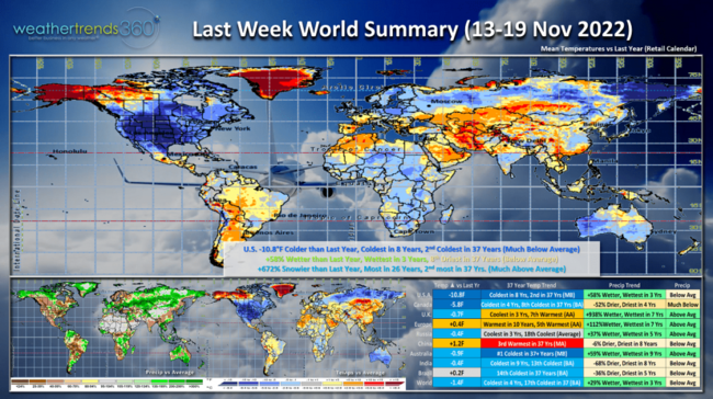
Canada was the coldest in 4 years while Europe was the warmest in 10 years - a negative for Fall seasonal merchandise sales.
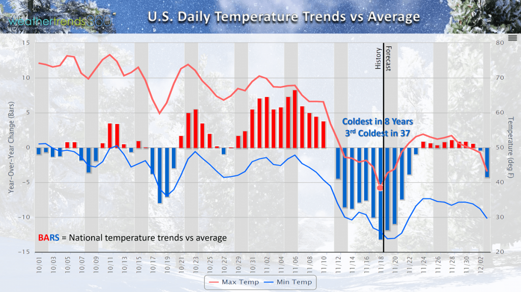
Daily national temperature trends show the cold start to October, warmer end into early November before the bottom fell out this past week. Now trends show a moderating trend into early December.
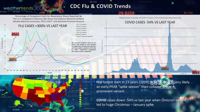
The very cold conditions at the start of October helped to get the FLU season off to the fastest start in 13 years with a huge spike season. Very possible we'll enter the peak about 6 weeks earlier than last year with a declining trend into the traditional peak of the season (Jan-Feb). COVID cases are down from last year when Omicron led to a huge spike in cases, doesn't appear there are any variants capable of a spike like last year.
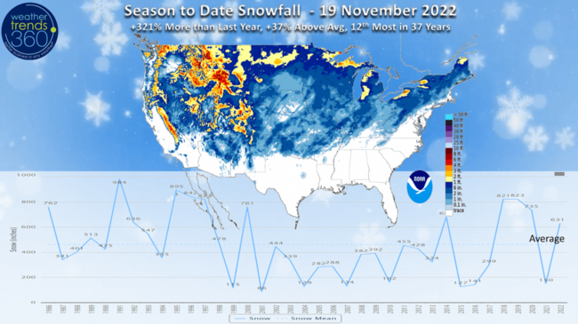
Season-to-date snowfall shows the U.S. trending up +321% more than a year ago, +37% above average and 12th most of the past 37 years. The snowy start will begin to wane over the next couple weeks with a drier pattern.
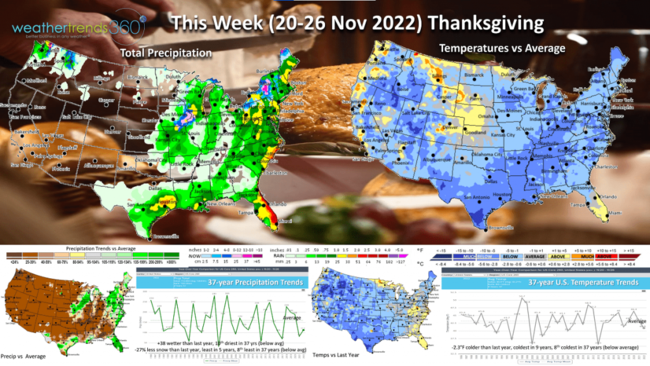
This Week (20-26 Nov) for the Thanksgiving holiday shows the U.S. trending -2.3F colder than last year, coldest in 9 years and 8th coldest of the past 37 years. Rainfall up +38% over last year but still 10th driest in 37 years with the heaviest rain along the East Coast. Snowfall is down -27% vs last year, least in 5 years and 8th least in 37 years.
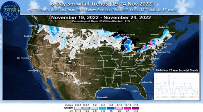
The 6-day snowfall outlook shows heavy snow limited to downwind of the Great Lakes with +177% more than last year, most in 4 years but still -46% below average nationally and 12th least of the past 37 years.
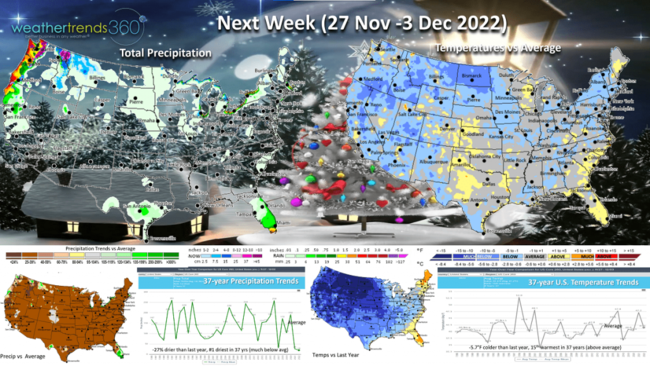
Next week (27 Nov - 3 Dec) shows temperatures beginning to moderate for the U.S. but still -5.7F colder than last year but 15th warmest in 37 years. The coldest spots shift to the West and Northern Plains. Rainfall -27% drier than last year making it the #1 driest in 37+ years. Snowfall also likely to be sparse and limited to the highest elevations of the Northwest.
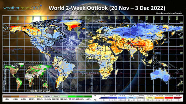
The 2-week World outlook (20 Nov - 3 Dec) shows the U.S., Russia, Australia and Brazil remain the cool spots, while Europe, China and the Middle East are the warm spots.
Have a great week, and don't forget to follow us on social media for frequent updates: Facebook, Twitter, YouTube, Pinterest and Linkedin.
- Captain Kirk out