Captain's Log 15 June '24 HOT End to June!
Captain's Log
15 June '24: Happy Saturday! :) Happy Father's Day Sunday.
https://www.youtube.com/watch?v=Jdita5g33Mg
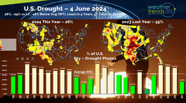
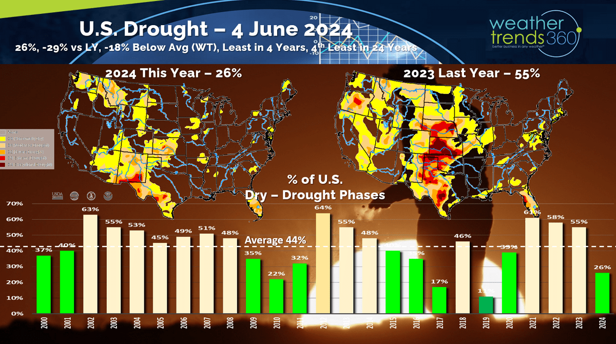
Drought across the U.S. has plummeted to just 26% of the U.S. in dry to drought phases which is well below the average coverage of 44%. This is the least in 5 years and 4th least in 24 years with a very wet pattern. CLICK ON IMAGES FOR A LARGER VIEW.
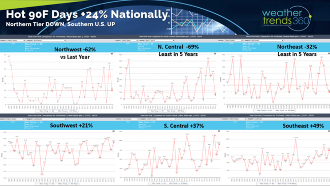
Hot 90F days are also way down across the Northern regions of the U.S. but up across the South. The Northeast has 32% less hot 90F days, least in 5 years and below average to date. This will get a boost with the pending 5-6 day heatwave moving in this week. The North Central is even more extreme with hot 90F days down -69%. The Southeast has the most hot 90F days trending +49% more than last year. Nationally, hot days are up +24% vs last year.
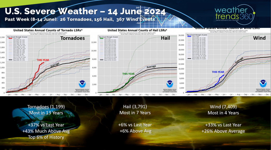
Severe weather slowed a bit this past week with 26 tornadoes, 156 hail events and 367 wind events. Tornadoes are still trending the most in 13 years and top 6% of history.
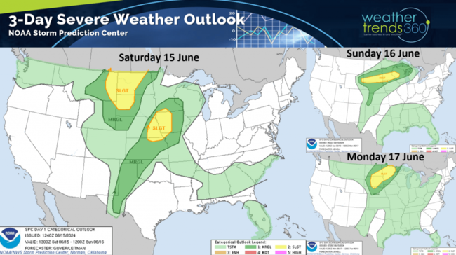
 The 3-day severe weather outlook shows the severe threat shifting to the Northern Plains and Upper Midwest.
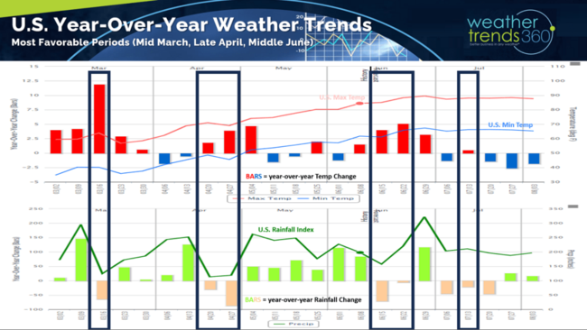
From Spring - Summer the most favorable weather for stronger seasonal merchandise sales is hotter/drier weeks compared to last year. We've only had 3 so far this Spring back in middle March, late April and now another favorable period here in middle June. The next two weeks should be very favorable for hot Summer seasonal categories.
Last week across the World (9-15 June) shows the U.S. trending +3.3F warmer than last year, 9th warmest in 39 years and -31% drier than last year, driest in 17 years and 4th driest of the past 39 years. These are favorable trends for seasonal merchandise sales, especially in the West where it was hotter than last year and vs average. The East was warmer than a year ago but still well below average temperatures dampening sales a bit. Florida had the most extreme weather with 10"+ rainfall totals across the southern half of the state putting an end to the dry pattern.
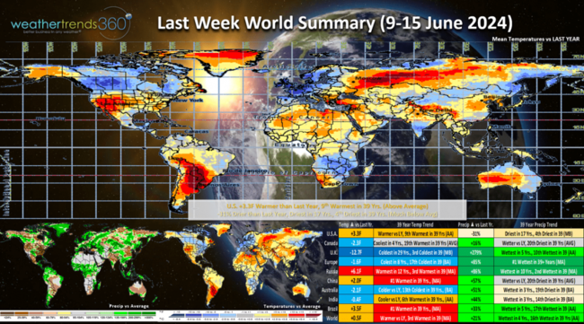
The U.K. and Europe were downright cool and very wet which is a bigger negative for seasonal sales.

There is a tropical threat this week for the Western Gulf of Mexico impacting Northern Mexico and Texas with potentially flooding rain. The National Hurricane Center shows a 50% chance we will get our first Tropical Storm of the season midweek. The name would be Alberto if it forms.
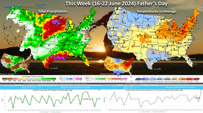
This week (16-22 June) trends +4.9F warmer than last year, warmest in 36 years and 2nd warmest in 39 years. The first heat wave of the season is headed for the Northeast with 5-6 days in a row of low to middle 90F temperatures with a chance for some bigger cities to approach 100F. Cooling trend toward the weekend. Rainfall down -2% vs last year but still 19th wettest of the past 39 years. Flooding risk for the Western Gulf of Mexico from Texas to Louisiana.

Next week (23-29 June) before July 4th shows the extreme heat shifting to the West with a bit cooler conditions in the East. Overall, the week trends +3.2F warmer than a year ago and #1 warmest of the past 39 years. Rainfall also #1 wettest in 39 years with national rainfall up +56% vs a year ago. The rain will dampen sales for some seasonal categories across the South.

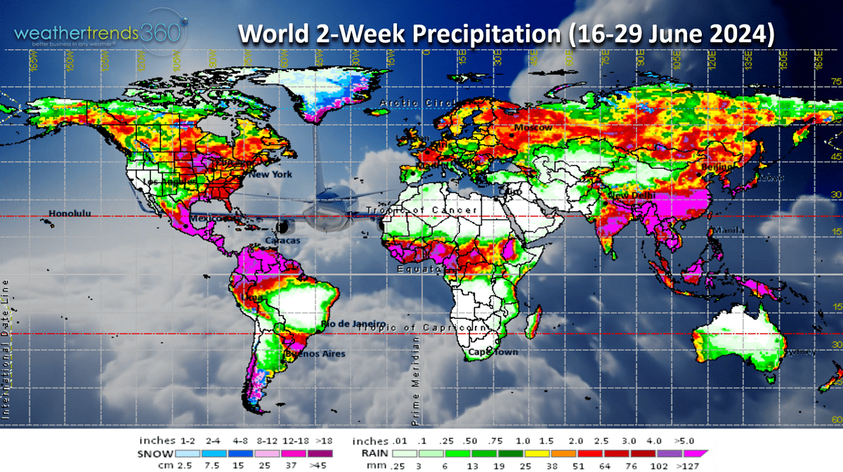
The World 2-week outlook (16-29 June) shows hot weather across the U.S. and a warming trend in Europe.

Rainfall remains heavy across the Southern U.S. and the Plains and Upper Midwest. Continued wet across Western Europe.
We hope you have a great Father's Day weekend and week ahead. Don't forget to follow us on social media for frequent updates: Facebook, Twitter, YouTube, Pinterest and Linkedin.
- Captain Kirk out.
https://www.youtube.com/watch?v=Jdita5g33Mg
Drought across the U.S. has plummeted to just 26% of the U.S. in dry to drought phases which is well below the average coverage of 44%. This is the least in 5 years and 4th least in 24 years with a very wet pattern. CLICK ON IMAGES FOR A LARGER VIEW.
Hot 90F days are also way down across the Northern regions of the U.S. but up across the South. The Northeast has 32% less hot 90F days, least in 5 years and below average to date. This will get a boost with the pending 5-6 day heatwave moving in this week. The North Central is even more extreme with hot 90F days down -69%. The Southeast has the most hot 90F days trending +49% more than last year. Nationally, hot days are up +24% vs last year.

Severe weather slowed a bit this past week with 26 tornadoes, 156 hail events and 367 wind events. Tornadoes are still trending the most in 13 years and top 6% of history.
The 3-day severe weather outlook shows the severe threat shifting to the Northern Plains and Upper Midwest.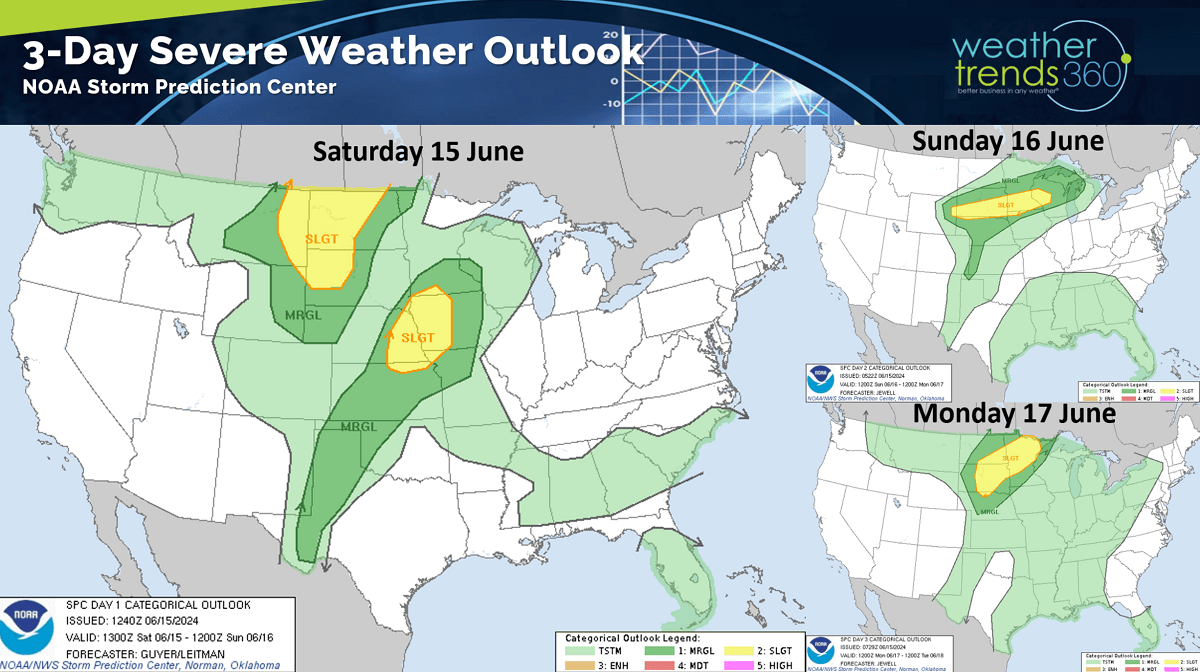
From Spring - Summer the most favorable weather for stronger seasonal merchandise sales is hotter/drier weeks compared to last year. We've only had 3 so far this Spring back in middle March, late April and now another favorable period here in middle June. The next two weeks should be very favorable for hot Summer seasonal categories.

Last week across the World (9-15 June) shows the U.S. trending +3.3F warmer than last year, 9th warmest in 39 years and -31% drier than last year, driest in 17 years and 4th driest of the past 39 years. These are favorable trends for seasonal merchandise sales, especially in the West where it was hotter than last year and vs average. The East was warmer than a year ago but still well below average temperatures dampening sales a bit. Florida had the most extreme weather with 10"+ rainfall totals across the southern half of the state putting an end to the dry pattern.

The U.K. and Europe were downright cool and very wet which is a bigger negative for seasonal sales.
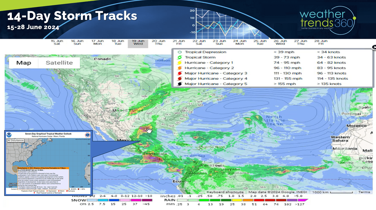
There is a tropical threat this week for the Western Gulf of Mexico impacting Northern Mexico and Texas with potentially flooding rain. The National Hurricane Center shows a 50% chance we will get our first Tropical Storm of the season midweek. The name would be Alberto if it forms.

This week (16-22 June) trends +4.9F warmer than last year, warmest in 36 years and 2nd warmest in 39 years. The first heat wave of the season is headed for the Northeast with 5-6 days in a row of low to middle 90F temperatures with a chance for some bigger cities to approach 100F. Cooling trend toward the weekend. Rainfall down -2% vs last year but still 19th wettest of the past 39 years. Flooding risk for the Western Gulf of Mexico from Texas to Louisiana.
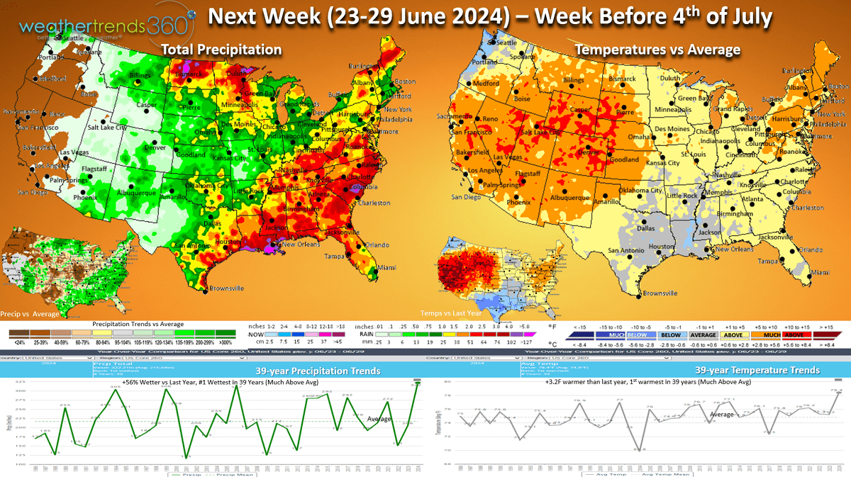
Next week (23-29 June) before July 4th shows the extreme heat shifting to the West with a bit cooler conditions in the East. Overall, the week trends +3.2F warmer than a year ago and #1 warmest of the past 39 years. Rainfall also #1 wettest in 39 years with national rainfall up +56% vs a year ago. The rain will dampen sales for some seasonal categories across the South.
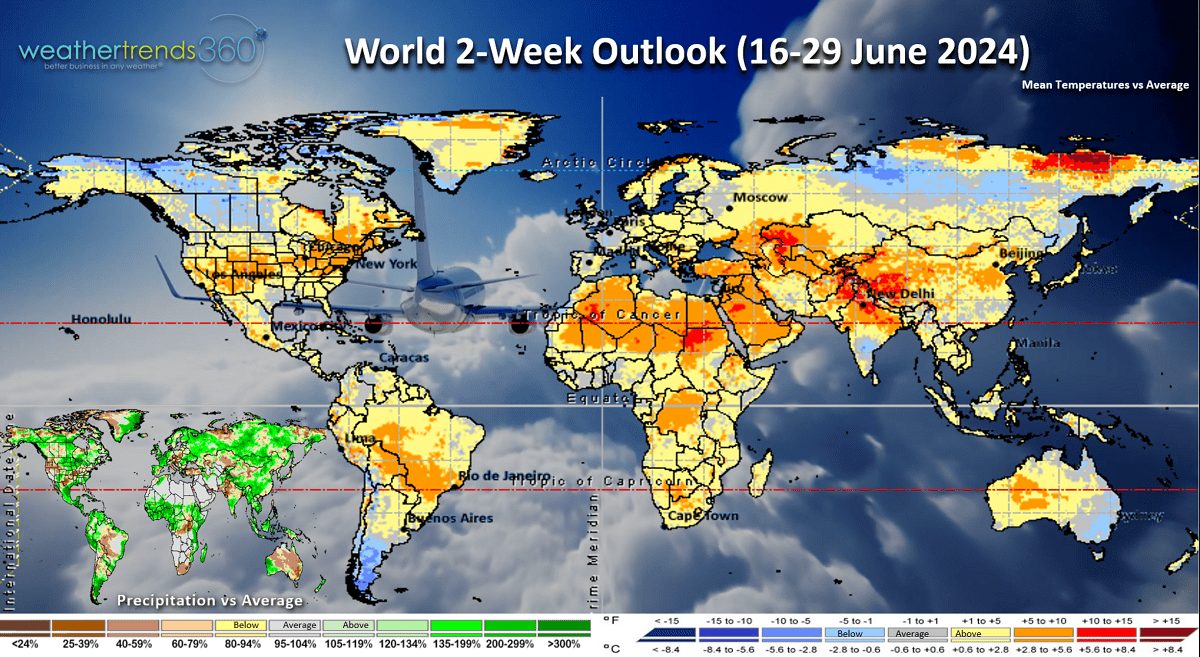
The World 2-week outlook (16-29 June) shows hot weather across the U.S. and a warming trend in Europe.
Rainfall remains heavy across the Southern U.S. and the Plains and Upper Midwest. Continued wet across Western Europe.
We hope you have a great Father's Day weekend and week ahead. Don't forget to follow us on social media for frequent updates: Facebook, Twitter, YouTube, Pinterest and Linkedin.
- Captain Kirk out.