Captain's Log 13 July Hot & Dry
Captain's Log
Happy Monday! :)
Hard to believe meteorological Summer is almost half over and according to the sun only 71 days until Fall...don't get too excited about cooler Fall weather as we have it pretty hot and dry into November! CLICK ON IMAGES FOR A LARGER VIEW.
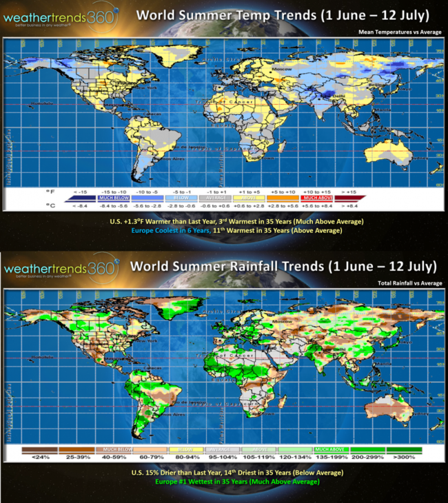
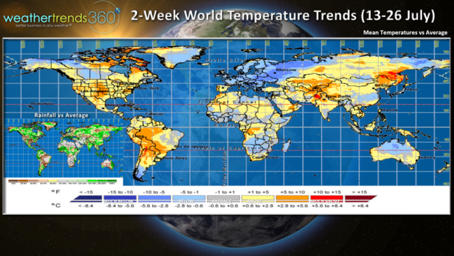
World weather trends for the front half of Summer show the U.S. trending 1.3F warmer than last year making it the 3rd warmest in 35 years with much above average national temperatures. This in part is due to reduced pollution levels due to COVID shutdowns allowing more solar radiation to reach the surface. More pollution, more sunlight is blocked keeping the surface a bit cooler. Europe overall is trending coolest in 6 years but still a bit above average. World rainfall trends show the U.S. trending 15% drier than last year and 14th driest of the past 35 years. 49% of the U.S. is now in dry to drought-like phases compared to only 10% this time last year when the nation was extremely wet. Europe is the wet spot trending #1 wettest overall in 35+ years.
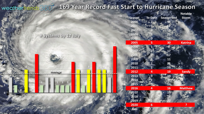
The other thing that is way up is the fastest start to 6 named storms in the Atlantic Basin in 169 years. With Tropical Storm Fay moving up the Middle Atlantic into Eastern PA Friday, we're on pace for well over 20 storms as WTI projected a year ago. Still very concerned about a major hurricane in the August - October time-frame for NYC Long Island areas, SE Florida and the North Central Gulf.
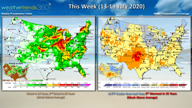
This week (13-19 July) is -0.5F cooler than last year but still 6th warmest of the past 35 years nationally. The cool spot is the Midwest with some spotty areas getting much needed rain. For the U.S. overall the week looks to trend driest in 14 years and 2nd driest in 35 years nationally. The tropics likely to take a break with an MJO tropical cycle phase becoming a bit less favorable for development.
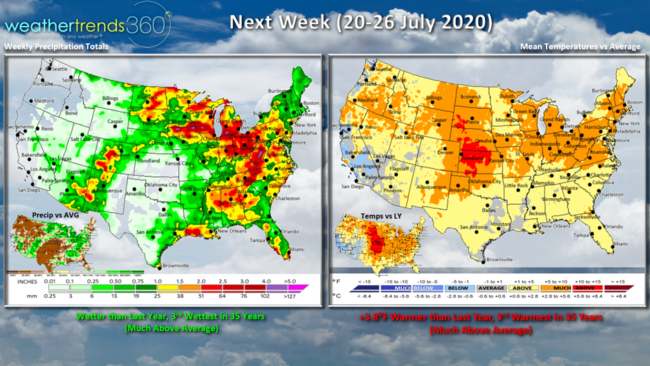
Next week (20-26 July) looks to trend +3.8F warmer than last year and 3rd warmest of the past 35 years with almost the entire country trending above average. The one cooler spot relative to normal is Southern California. Rainfall wetter than last year and 3rd wettest in 35 years nationally. Hopefully more beneficial rainfall for the parched Upper Plains and Midwest.
The 2-week World trends show the very warm trends across the U.S. but cooler across Central Canada and much of Europe and West Russia. A bit drier across Europe.
Have a great week and don't forget to follow us on social media for frequent updates. Facebook, Twitter, YouTube, Pinterest and Linkedin