Captain's Log 13 Aug '24 Tropics Becoming Active
Captain's Log
13 August 2024: August was off to a soggy start along the East Coast as Hurricane Debby made landfall in Florida's Big Bend area early last week and then meandered over the Southeast for several days dumping feet of rain in some locations. River and flash flooding was reported up and down the East Coast last week. Debby finally exited the U.S. over the weekend leaving flooding and wind damage in her wake. We're still early in the Atlantic Hurricane season and WT360 expects many more storms to develop this season.
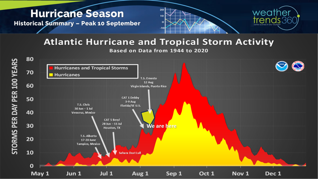
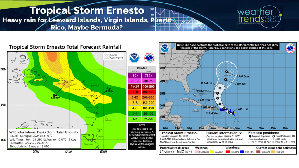
Speaking of, we're already tracking the next tropical storm in the Atlantic, Ernesto. Ernesto is projected to affect the Leeward and U.S. Virgin Islands and Puerto Rico. The storm curves northward well before reaching the U.S. mainland and likely strengthens into a hurricane, but this track may put Bermuda in the crosshairs. It's still too far out to say for sure, but the Canadian Maritimes will need to keep an eye on Ernesto as the storm could bring heavy rain and strong winds early next week.
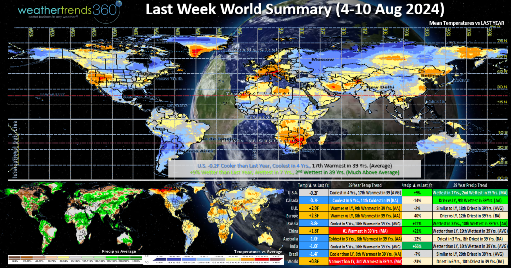
Last Week (4-10 Aug) Debby certainly helped make the first full week of August 2024 one of the wettest in 40 years with much wetter than normal trends all along the East Coast. The Desert Southwest and portions of the Rockies also saw above normal precipitation as the monsoon remained active. The big dry spot was from South and East Texas and across a large portion of the Mississippi River Valley.
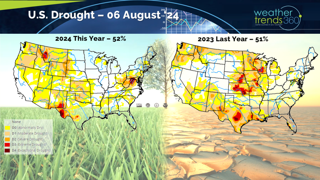
Debby did help to ease drought conditions in Florida, Georgia, and South Carolina but at a price. It's likely we'll see further improvement in the drought map this week as the map below only covers data through Tuesday, August 6th and heavy rain last week lasted well into Friday. The Mid-Atlantic should see some improvements after several inches of rain fell towards the end of last week.
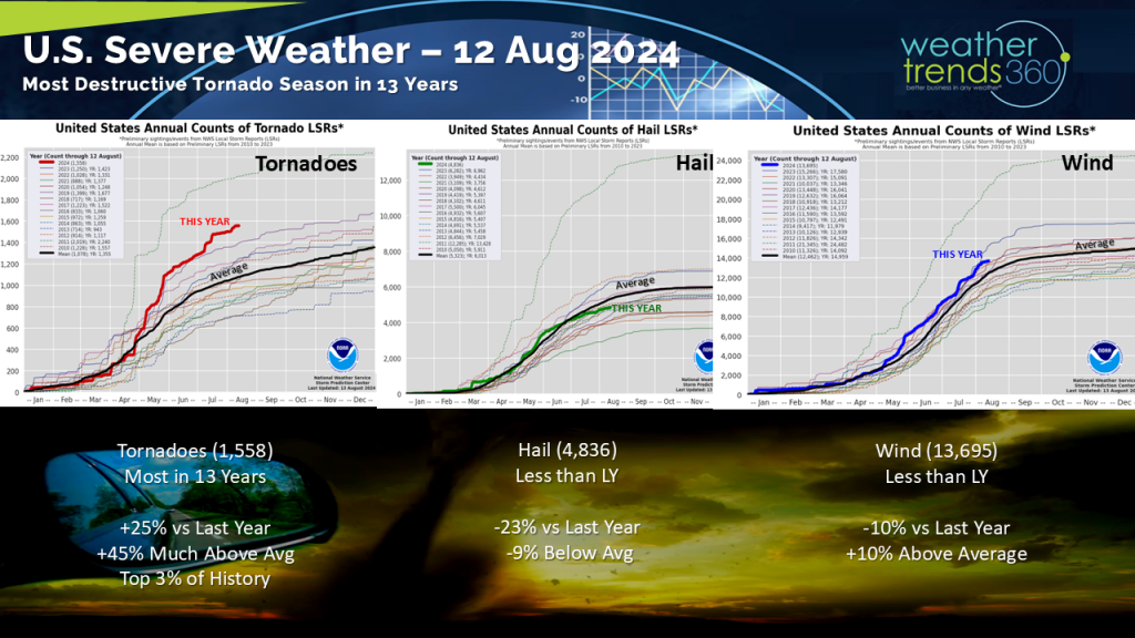
Debby also helped to add to the tornado count for the year. Year-to-date the tornado count is the most in 13 years and much above average.
A cooling trend arrived in the North Central states following a hot start to last week. Cooler trends at this time of year benefit Back-to-School shopping and get consumers thinking ahead to autumn. Autumn was nowhere in sight for the West as hot weather persisted. The heat continued to support demand for summer consumables such as cold beverages and sun lotion.
Around the globe, Canada cooled down from late July when it was hot. Remnants of Debby brought heavy downpours to the major cities in the East, including Montreal which saw its wettest day on record Friday with over 6'' of rain! Europe remained warmer, including some hotter weather in Paris for the Olympics. China saw the hottest first full week of August in 40 years, while Australia and Brazil trended cooler compared to last year.
This week (11-17 Aug) a much-welcomed cooler and drier pattern starts the week across the Mid-Atlantic and Northeast. Unsettled weather arrives just in time for the weekend in the Northeast, but this could be good news for retailers as this would force more consumers indoors which tends to favor Back-to-School shopping at this time of year.
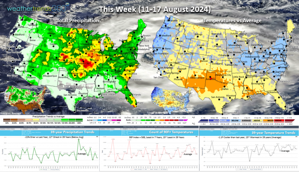
Lingering moisture in the Carolinas and additional chances of showers and storms will keep the flood risk alive there. The Southwest Monsoon is expected to remain active so additional showers and storms will fire up across the Desert Southwest and southern/central Rockies. The Northwest will see much cooler temperature trends compared to both the week and year prior. Heat will build across the South with drier than normal conditions which should keep sales strong for summer consumable categories, like bottled water, beer, and ice cream.
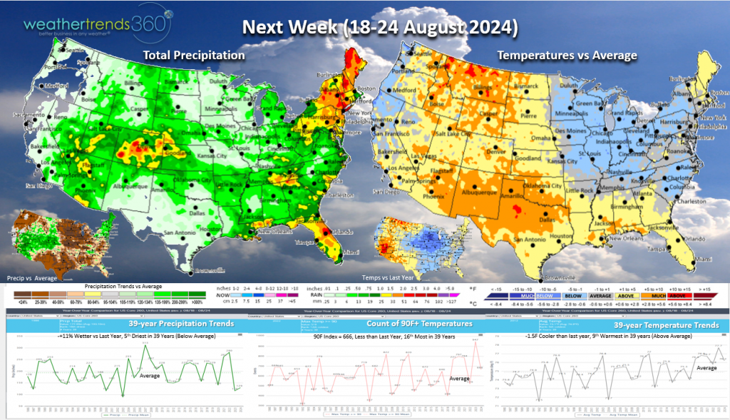
Next Week (18-24 Aug) we'll be comparing to one of the hottest third weeks of August in nearly 40 years for the nation. Trending much cooler than a hot comparable week last year across the Midwest with temperatures closer to or below normal. Hotter weather will be favored for the Intermountain West and Rocky Mountains where it will be MUCH drier than last year. Recall that last year, Tropical Storm Hilary made a rare southern California landfall resulting in flash flooding and heavy rain that spread all the way to the Northwest and Northern Rockies. This year, precipitation arrives mainly in the form of monsoon showers and storms for the Desert Southwest and Southern Rockies. The unsettled conditions from the upcoming weekend may bleed over into next week for the Northeast bringing several days of showers and storm chances to the region.
The World 2-week outlook (11-24 Aug) shows continued warmer trends in Europe, including one of the hottest days of the year in England early this week. Cooler temperatures are expected to return to the U.K. by late this week with hotter weather reserved to southern Europe.
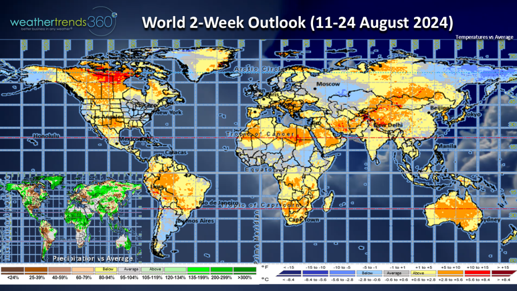
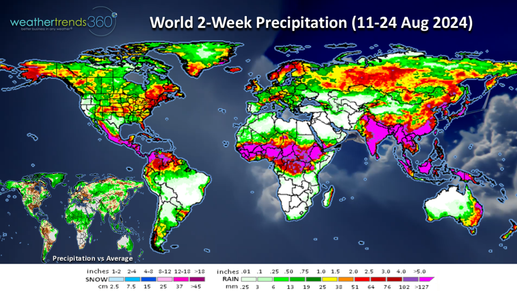
World 2-week rainfall (11-24 Aug) shows the possibility of heavier rain in the Canadian Maritimes possibly due to Ernesto's arrival early next week.
We hope you have a great week ahead, and don't forget to follow us on social media for frequent updates: Facebook, Twitter, YouTube, Pinterest and Linkedin.
Speaking of, we're already tracking the next tropical storm in the Atlantic, Ernesto. Ernesto is projected to affect the Leeward and U.S. Virgin Islands and Puerto Rico. The storm curves northward well before reaching the U.S. mainland and likely strengthens into a hurricane, but this track may put Bermuda in the crosshairs. It's still too far out to say for sure, but the Canadian Maritimes will need to keep an eye on Ernesto as the storm could bring heavy rain and strong winds early next week.
Last Week (4-10 Aug) Debby certainly helped make the first full week of August 2024 one of the wettest in 40 years with much wetter than normal trends all along the East Coast. The Desert Southwest and portions of the Rockies also saw above normal precipitation as the monsoon remained active. The big dry spot was from South and East Texas and across a large portion of the Mississippi River Valley.
Debby did help to ease drought conditions in Florida, Georgia, and South Carolina but at a price. It's likely we'll see further improvement in the drought map this week as the map below only covers data through Tuesday, August 6th and heavy rain last week lasted well into Friday. The Mid-Atlantic should see some improvements after several inches of rain fell towards the end of last week.
Debby also helped to add to the tornado count for the year. Year-to-date the tornado count is the most in 13 years and much above average.
A cooling trend arrived in the North Central states following a hot start to last week. Cooler trends at this time of year benefit Back-to-School shopping and get consumers thinking ahead to autumn. Autumn was nowhere in sight for the West as hot weather persisted. The heat continued to support demand for summer consumables such as cold beverages and sun lotion.
Around the globe, Canada cooled down from late July when it was hot. Remnants of Debby brought heavy downpours to the major cities in the East, including Montreal which saw its wettest day on record Friday with over 6'' of rain! Europe remained warmer, including some hotter weather in Paris for the Olympics. China saw the hottest first full week of August in 40 years, while Australia and Brazil trended cooler compared to last year.
This week (11-17 Aug) a much-welcomed cooler and drier pattern starts the week across the Mid-Atlantic and Northeast. Unsettled weather arrives just in time for the weekend in the Northeast, but this could be good news for retailers as this would force more consumers indoors which tends to favor Back-to-School shopping at this time of year.
Lingering moisture in the Carolinas and additional chances of showers and storms will keep the flood risk alive there. The Southwest Monsoon is expected to remain active so additional showers and storms will fire up across the Desert Southwest and southern/central Rockies. The Northwest will see much cooler temperature trends compared to both the week and year prior. Heat will build across the South with drier than normal conditions which should keep sales strong for summer consumable categories, like bottled water, beer, and ice cream.
Next Week (18-24 Aug) we'll be comparing to one of the hottest third weeks of August in nearly 40 years for the nation. Trending much cooler than a hot comparable week last year across the Midwest with temperatures closer to or below normal. Hotter weather will be favored for the Intermountain West and Rocky Mountains where it will be MUCH drier than last year. Recall that last year, Tropical Storm Hilary made a rare southern California landfall resulting in flash flooding and heavy rain that spread all the way to the Northwest and Northern Rockies. This year, precipitation arrives mainly in the form of monsoon showers and storms for the Desert Southwest and Southern Rockies. The unsettled conditions from the upcoming weekend may bleed over into next week for the Northeast bringing several days of showers and storm chances to the region.
The World 2-week outlook (11-24 Aug) shows continued warmer trends in Europe, including one of the hottest days of the year in England early this week. Cooler temperatures are expected to return to the U.K. by late this week with hotter weather reserved to southern Europe.
World 2-week rainfall (11-24 Aug) shows the possibility of heavier rain in the Canadian Maritimes possibly due to Ernesto's arrival early next week.
We hope you have a great week ahead, and don't forget to follow us on social media for frequent updates: Facebook, Twitter, YouTube, Pinterest and Linkedin.