Captain's Log 12 Jul '24 Cool in the Middle, Warm on the Ends
Captain's Log
12 July 2024: Happy Friday! :) Yes, we're a day early!
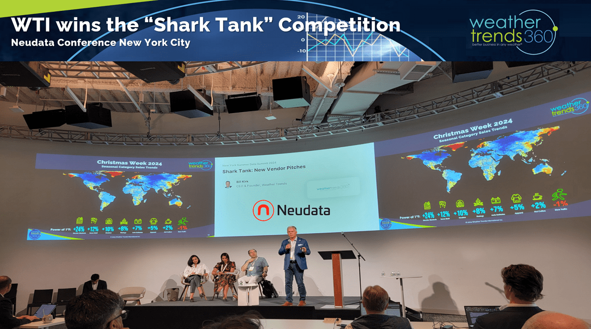
We spoke at the Neudata Financial Services Conference in New York City and won the "Shark Tank" competition...everyone loves YEAR-AHEAD weather! CLICK ON IMAGES FOR A LARGER VIEW.

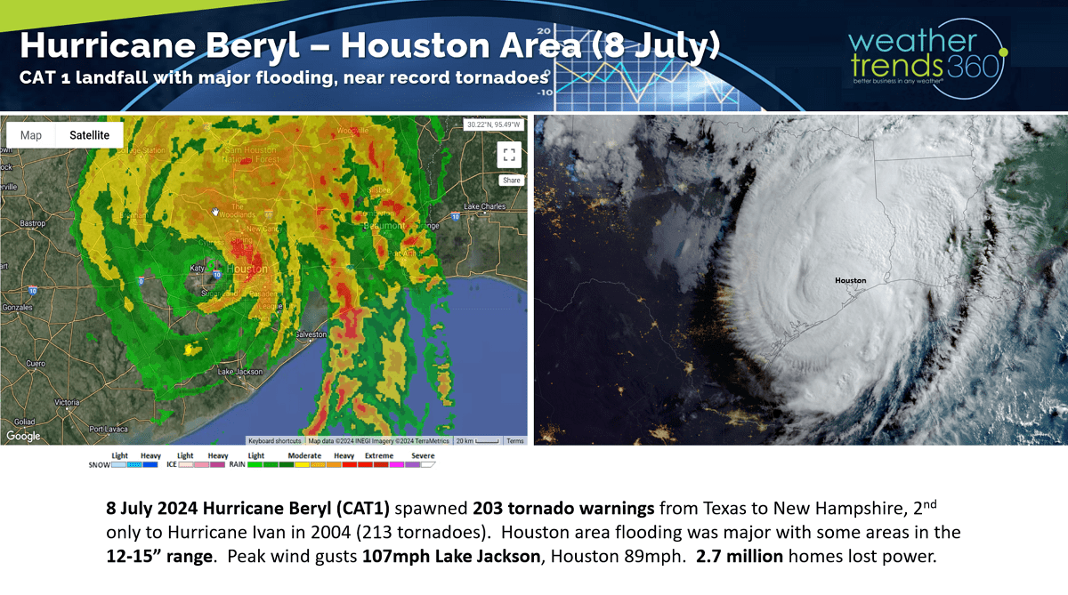
The big news this week has been CAT 1 Hurricane Beryl landfall just to the Southwest of the Houston metro area. For a CAT 1 it was an impressive hurricane with 203 tornado warnings, the most since Hurricane Ivan back in 2004 which had 213. Wind gusts to 107 mph at Lake Jackson and 89mph in Houston with 12-15" of flooding rains and 2.7 million without power. Sadly, we think this is just the first of a couple more for TX this hurricane season.

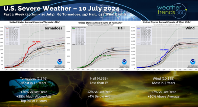
Due in large part to Hurricane Beryl, severe weather continued its fast pace with 69 more confirmed tornadoes, 197 hail events and 947 wind events across the U.S. Tornadoes continue to trend the most in 13 years and the top 9% of history as predicted by WTI a year-ahead.
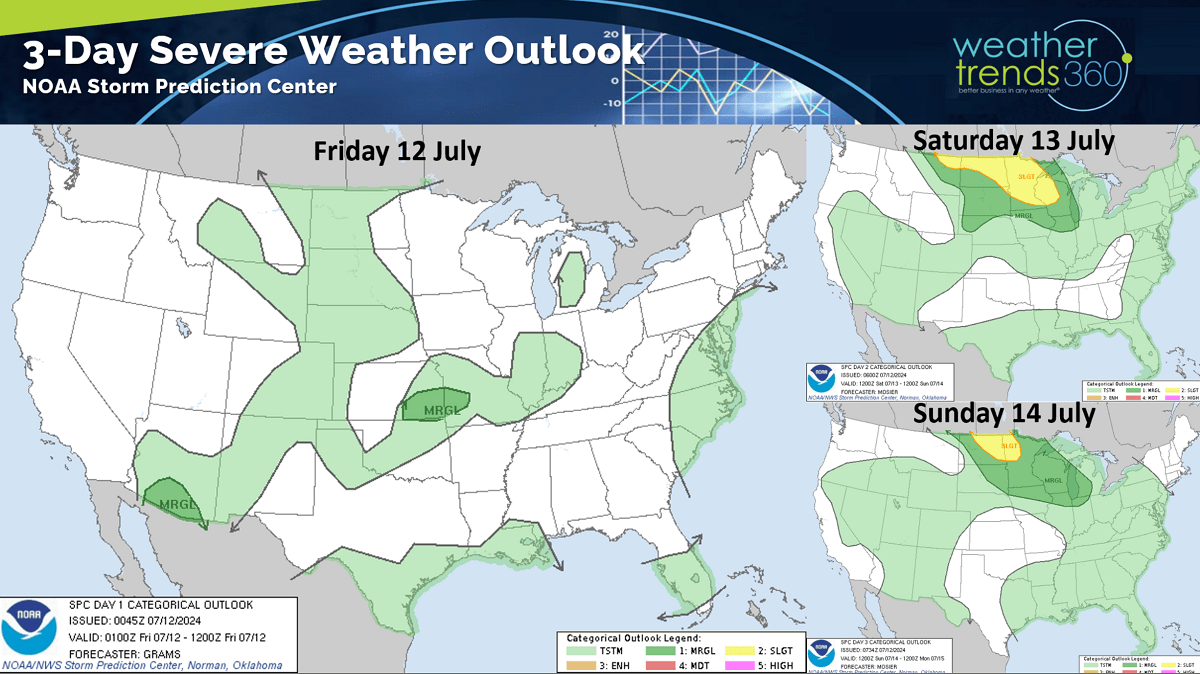
The severe weather threat this weekend will shift back into the Upper Plains.

Last week (7-13 July) shows the U.S. trending +2.8F warmer than last year and #1 warmest of the past 39 years. Rainfall is down -12% vs last year, 19th driest of the past 39 years so near average for the U.S. overall. The "cool" spot was the South-Central U.S. due to all the rains with Beryl while the West Coast baked. These are favorable trends for hot seasonal categories and storm related merchandise.
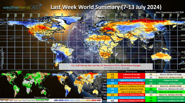
The U.K. was the cold spot with continued very wet conditions on a global scale due in large part to the Tonga Volcano pumping up so much water vapor and the weakening El Niño to La Niña climate cycle.
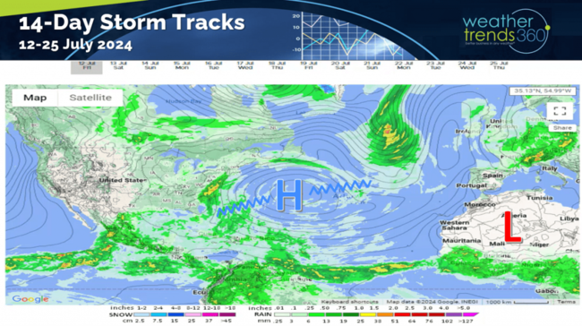 The 14-day storm track shows the Bermuda high shifting a bit which will allow a conveyor belt of tropical moisture to concentrate along the East Coast. Much needed with drought like conditions in the Southeast. This also could allow a tropical system to form quickly near the Southeast Coast, nothing imminent.
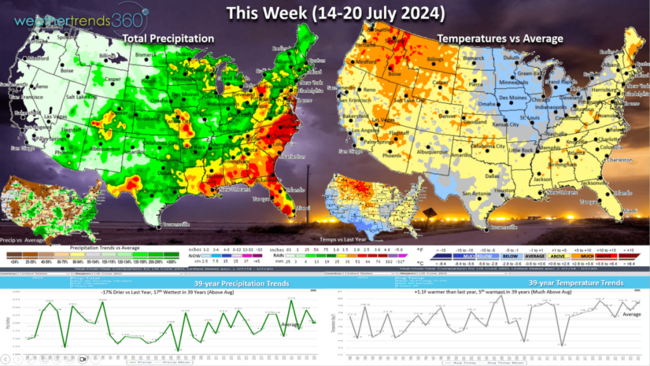
This week (14-20 July) shows the continued cool pattern for the Central U.S. where hot 90F days are actually the least in 5 years. Minneapolis as an example has had zero 90F days vs 14 last year which was the most in 35 years. The heat has been more focused on the West Coast and the East Coast. This week the Northwest is the hot spot while the Southeast is the wettest. The U.S. overall trends +1.1F warmer than last year, 5th warmest in 39 years, while rainfall is down -17% vs last year but still 17th wettest of the past 39 years and above average.
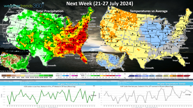
Next week (21-27 July) shows continued stormy wet weather for the Eastern half of the U.S. with a continued surge of warm and humid air around the Bermuda High. Continued cool in the Central U.S. with continued heat in the NW only not as extreme. The U.S. overall trends -0.6F cooler than last year, coolest in 3 years and 12th warmest of the past 39 years, while rainfall is up +52% and most in 4 years nationally.
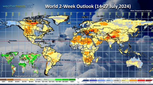
The World 2-week outlook (14-27 July) shows the cooler trends in the Central U.S., hot west, humid Eastern U.S. The UK continues to be cool.
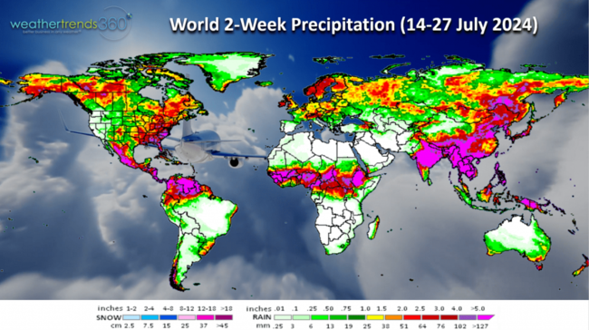
World rainfall shows widespread 4-6" totals for the Southeast - much needed drought relief.
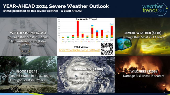
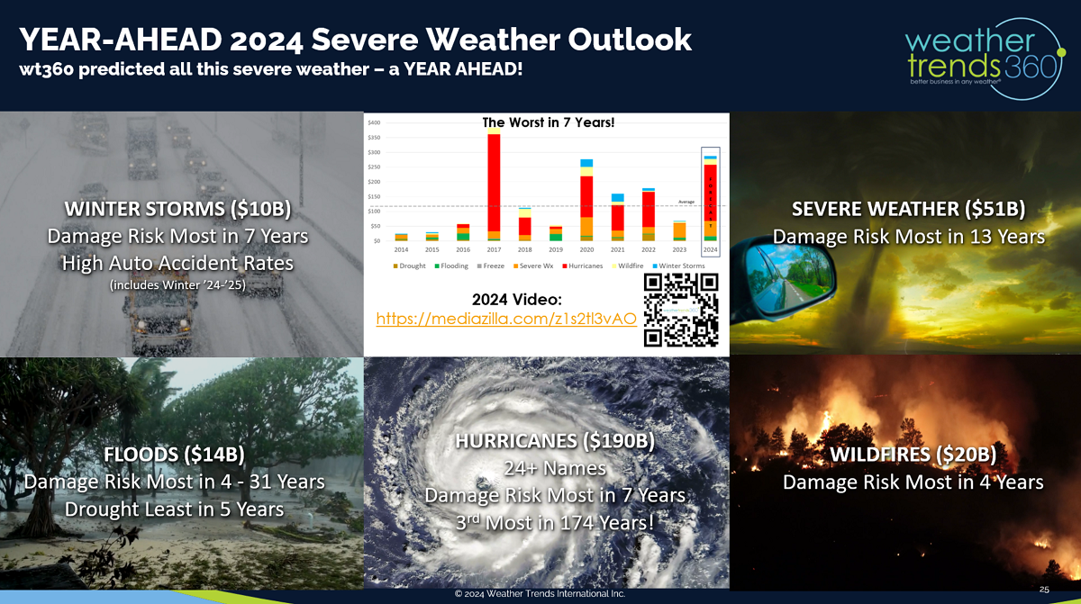
We'll end with our year-ahead 2024 severe weather outlook that has accurately captured all this severe weather in the U.S. Unfortunately it's not over with hurricanes likely to be very damaging as we enter the peak Aug - Oct season.
Have a great weekend and week ahead. Don't forget to follow us on social media for updates: Facebook, Twitter, YouTube, Pinterest and Linkedin.
- Captain Kirk out.
We spoke at the Neudata Financial Services Conference in New York City and won the "Shark Tank" competition...everyone loves YEAR-AHEAD weather! CLICK ON IMAGES FOR A LARGER VIEW.
The big news this week has been CAT 1 Hurricane Beryl landfall just to the Southwest of the Houston metro area. For a CAT 1 it was an impressive hurricane with 203 tornado warnings, the most since Hurricane Ivan back in 2004 which had 213. Wind gusts to 107 mph at Lake Jackson and 89mph in Houston with 12-15" of flooding rains and 2.7 million without power. Sadly, we think this is just the first of a couple more for TX this hurricane season.
Due in large part to Hurricane Beryl, severe weather continued its fast pace with 69 more confirmed tornadoes, 197 hail events and 947 wind events across the U.S. Tornadoes continue to trend the most in 13 years and the top 9% of history as predicted by WTI a year-ahead.

The severe weather threat this weekend will shift back into the Upper Plains.
Last week (7-13 July) shows the U.S. trending +2.8F warmer than last year and #1 warmest of the past 39 years. Rainfall is down -12% vs last year, 19th driest of the past 39 years so near average for the U.S. overall. The "cool" spot was the South-Central U.S. due to all the rains with Beryl while the West Coast baked. These are favorable trends for hot seasonal categories and storm related merchandise.

The U.K. was the cold spot with continued very wet conditions on a global scale due in large part to the Tonga Volcano pumping up so much water vapor and the weakening El Niño to La Niña climate cycle.
 The 14-day storm track shows the Bermuda high shifting a bit which will allow a conveyor belt of tropical moisture to concentrate along the East Coast. Much needed with drought like conditions in the Southeast. This also could allow a tropical system to form quickly near the Southeast Coast, nothing imminent.
This week (14-20 July) shows the continued cool pattern for the Central U.S. where hot 90F days are actually the least in 5 years. Minneapolis as an example has had zero 90F days vs 14 last year which was the most in 35 years. The heat has been more focused on the West Coast and the East Coast. This week the Northwest is the hot spot while the Southeast is the wettest. The U.S. overall trends +1.1F warmer than last year, 5th warmest in 39 years, while rainfall is down -17% vs last year but still 17th wettest of the past 39 years and above average.

Next week (21-27 July) shows continued stormy wet weather for the Eastern half of the U.S. with a continued surge of warm and humid air around the Bermuda High. Continued cool in the Central U.S. with continued heat in the NW only not as extreme. The U.S. overall trends -0.6F cooler than last year, coolest in 3 years and 12th warmest of the past 39 years, while rainfall is up +52% and most in 4 years nationally.
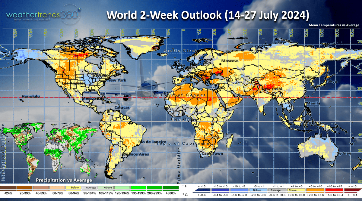
The World 2-week outlook (14-27 July) shows the cooler trends in the Central U.S., hot west, humid Eastern U.S. The UK continues to be cool.

World rainfall shows widespread 4-6" totals for the Southeast - much needed drought relief.
We'll end with our year-ahead 2024 severe weather outlook that has accurately captured all this severe weather in the U.S. Unfortunately it's not over with hurricanes likely to be very damaging as we enter the peak Aug - Oct season.
Have a great weekend and week ahead. Don't forget to follow us on social media for updates: Facebook, Twitter, YouTube, Pinterest and Linkedin.
- Captain Kirk out.