Captain's Log 12 Dec '21 Stormy Pattern Ahead
Captain's Log
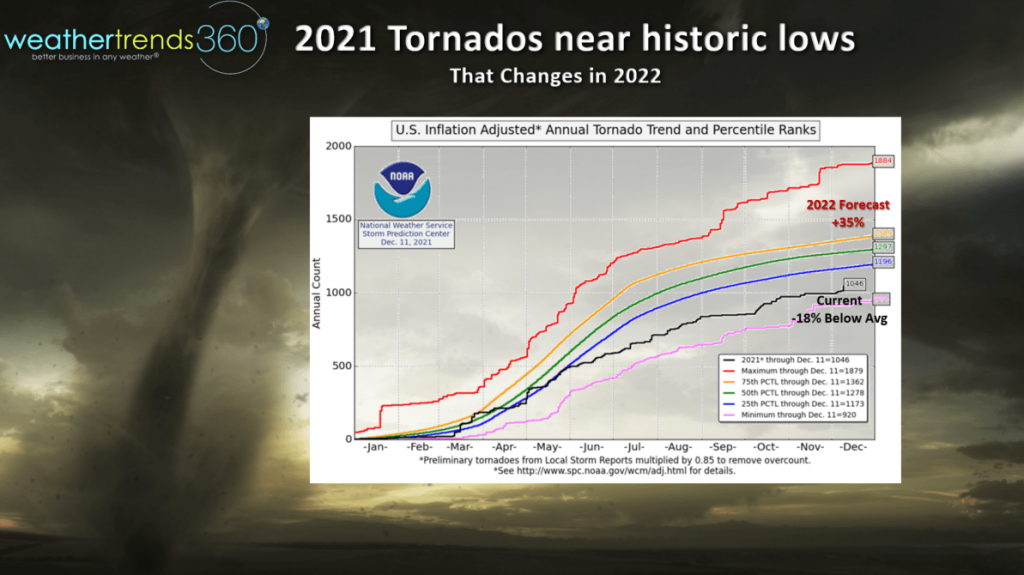
While tornadoes have been well below average this year (18% below average), the number of fatalities has been very high with some direct hits to higher populated cities. Prayers for everyone suffering with this catastrophic event.
CLICK ON IMAGES FOR A LARGER VIEW. Unfortunately this may be just the start of what should be a very active 2022 season for tornadoes, up 35% over this year is our early projection.
 This Super Cell Thunderstorm that tracked for about 250 miles from Arkansas to SE Missouri, Western Tennessee and Western Kentucky MIGHT go down in the history books for the longest duration tornado covering 250 miles. The current record for the longest tornado on the ground was back in March of 1925 from Missouri to Indiana.
Last week we sent our farmer customers the 2022 Agriculture video update for the year ahead; some hurdles remain for farmers in South America and here in the states, but the La Niña drought cycle is likely to end as we go through the 2022 season.
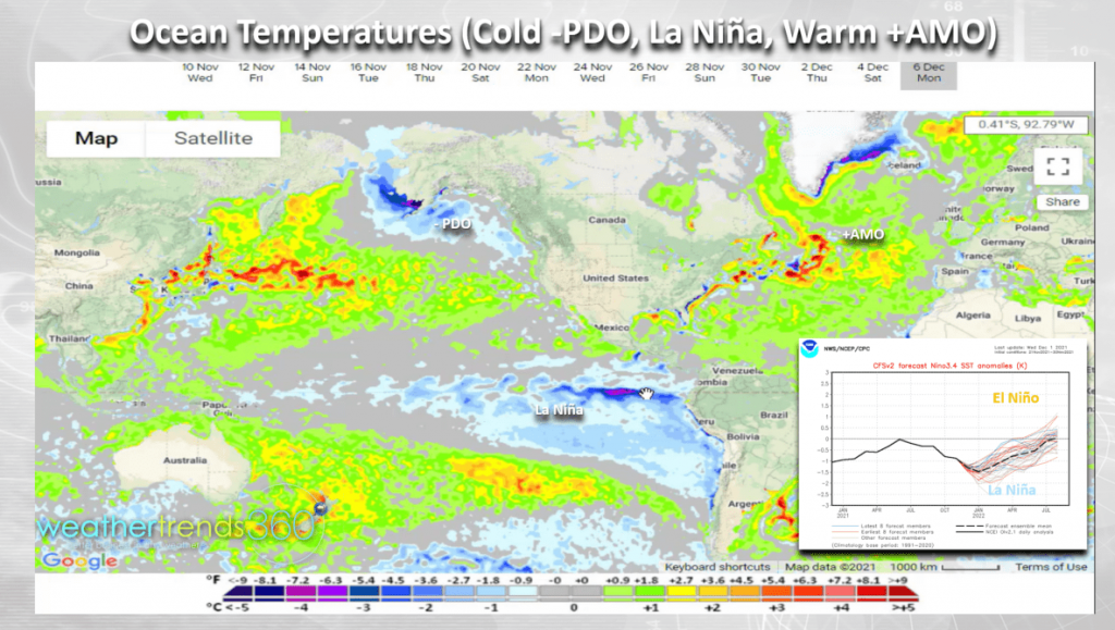 Some of the unusual cycles that have teemed up is the moderate La Nina event, coldest equatorial Pacific in 14 years while the North Pacific PDO cycle is the 2nd coldest in 165 years. In the Atlantic, the #1 warmest AMO cycle, so a lot of unusual cycles here that will play a major role in 2022.
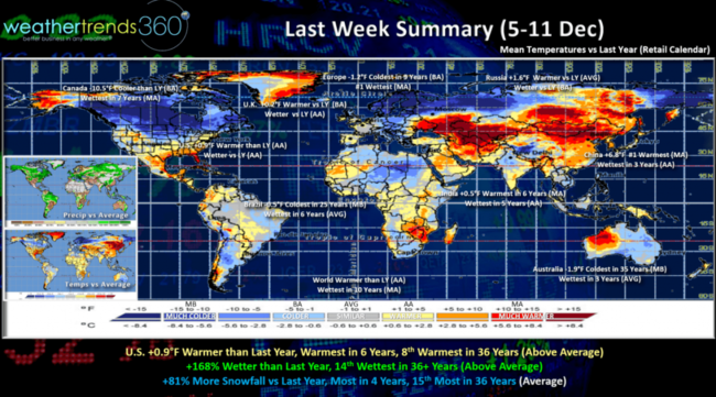
Last week (5-11 Dec) across the World shows the U.S. trending +0.9F warmer than last year, warmest in 6 years and 8th warmest of the past 36 years. Rainfall was finally up 168% over last year and 14th wettest of the past 36 years. Canada has turned remarkably colder as some of the Siberian air finally invaded causing temperatures to plunge 10.5F colder than a year ago, a huge benefit to seasonal category sales. The U.K. and Europe continue to trend cold as well with the EU the coldest in 9 years and #1 wettest with some snow. Still very cold in Australia's Spring with the coldest conditions in 35 years.
With the U.S. Midwest snow storm, national snowfall was finally way up +81% over last year, most in 4 years and 15th most in 36 years.
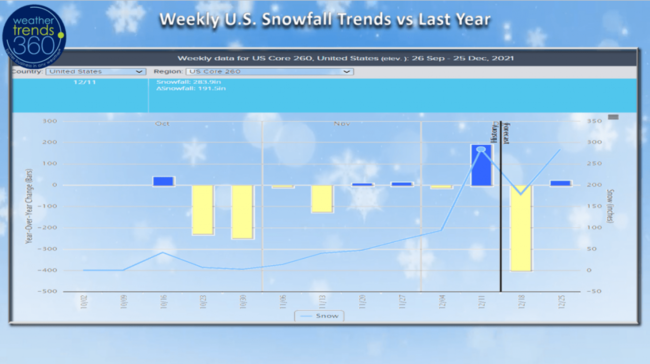
The October to December snowfall trends in the U.S. compared to last year show the big snowier week last week benefiting snow accessories.
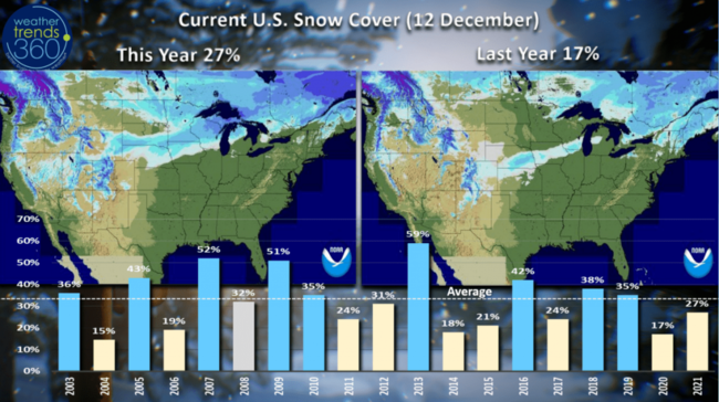
The Northern tier of the U.S. was the most favorable spots for early Winter seasonal merchandise after the system that moved out of the Rockies into the Upper Midwest. U.S. snow cover was 27% on Sunday, up from only 17% last year. Very hot in the Southern U.S. continues to benefit outdoor construction categories.
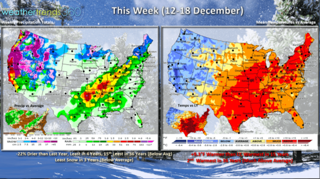
This Week (12-18 Dec) shows temperatures trending a whopping +9.3F warmer than last year, warmest in 15 years and 2nd warmest of the past 36 years. But, a bigger change appears to be setting up as a very strong, unusual, storm brings colder and much snowier weather to the West. Some of this will eventually spill East as the storm traverses the U.S. This could set the stage for another severe weather event (minor) late this week into the weekend. National rainfall down 22% vs a year ago, least in 4 years and 15th least of the past 36. But, very heavy rain in the parched West, even well into southern California where flash flooding and mudslides are likely.
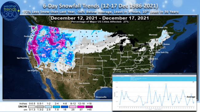
The 6-day snowfall outlook (12-18 Dec) shows the Sierra's of California likely to end up with 3-9 feet of snow in the highest elevations.
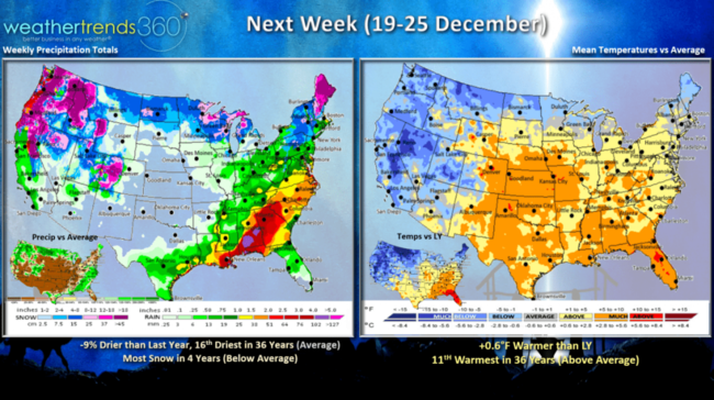
Next Week (19-25 Dec) trends +0.6F warmer than last year and 11th warmest of the past 36 years. There will be a few colder days right before Christmas in the Northeast with a snow threat as some of this moisture in the West traverses the country. National rainfall overall down about 9% with snowfall the least in 4 years.
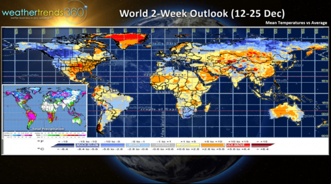
The 2-week World outlook (12-25 Dec) shows the colder Siberian air is building and some of that is moving into the Western half of North America. Eventually this will spread across Eastern North America for late December into January.
Have a great week, a don't forget to follow us on social media for frequent updates: Facebook, Twitter, YouTube, Pinterest and Linkedin
- Captain Kirk out.