Captain's Log 11 Nov '23 Very Warm then Very Snowy
Captain's Log
11 Nov '23: Happy Veteran's Day Saturday. :)
Happy Veteran's Day 2023, we have a nice blue-sky day here at wt360 HQ in Bethlehem PA. CLICK ON IMAGES FOR A LARGER VIEW.

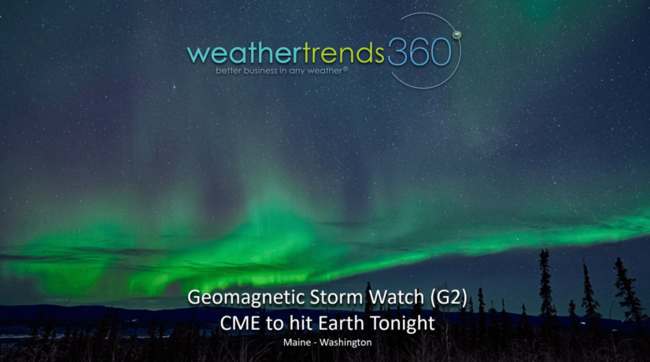
Another CME is headed our way with a G2 level solar storm tonight. This could lead to some auroras from Maine to Washington across the Northern tier of the U.S. November has been active on this front with auroras seen deep into the U.S. TBD if this one will be as strong as the earlier week event. Midnight local time is usually the best viewing across the northern horizon.
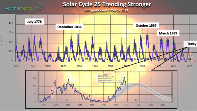
Solar Cycles are important as they due influence the oceans and ultimately the weather cycles. Solar Cycle #25 is weaker by historical standards but trending stronger than forecast. This, will likely make for an active aurora season this Winter. Peak likely in 2024.
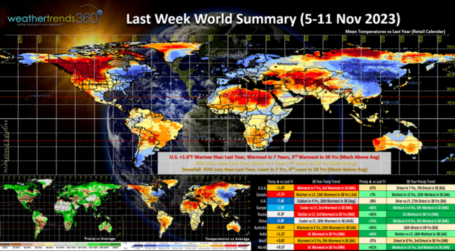
Last week (5-11 Nov) across the World shows the U.S. trending +1.6F warmer than last year, warmest in 7 years and 3rd warmest of the past 38 years. Rainfall -67% drier than last year, also driest in 7 years and 7th driest of the past 38. Snowfall -93% less than a year ago, least in 7 years and 4th least in 38 years. These are very unfavorable trends for Fall seasonal merchandise sales. The U.K. showed the greatest change toward much colder weather, coldest in 4 years while India was the warmest in over 38 years. While Europe was cooler than last year, still 2nd warmest in 38 years. All adds up to soft seasonal merchandise sales.
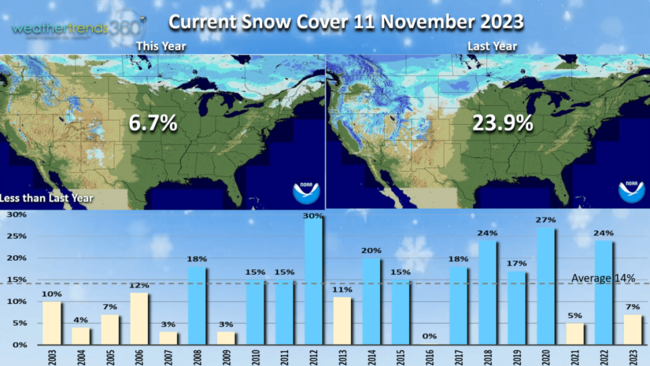
Snow Cover this morning across the U.S. was 6.7% vs 23.9% coverage last year. 14% is typical for this time of year.
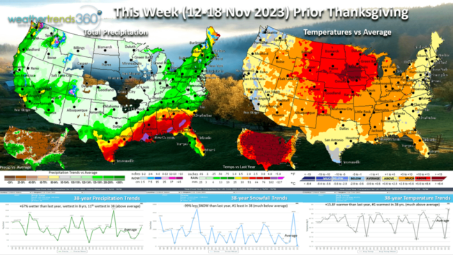
This week (12-18 Nov) prior to Thanksgiving is very unfavorable for retail seasonal sales with national temperatures trending +15.8F warmer than last year going from 2nd coldest last year to #1 warmest this year. Rainfall up +67% vs last year, wettest in 8 years and 11th wettest in 38 years. Southern California may get 1"+ rainfall. Snowfall down -99% vs last year which was exceptionally snowy. So very cold/snowy last year to warm and no snow this year will bring strong double-digit DECLINES in seasonal sales.
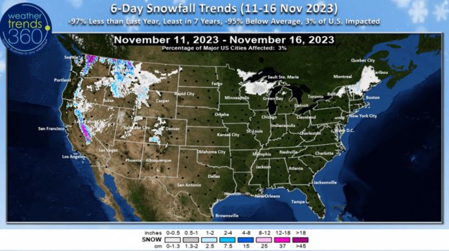
The 6-day snowfall outlook shows the Sierras getting their first big snow, but where people live, snowfall is down -97% vs last year and least in 7 years with only 3% of the U.S. population having snow.
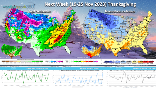
Next week (19-25) Thanksgiving shows signs of a pattern change with a strong cold front invading the U.S. While national temperatures are +2.8F warmer than last year, warmest in 3 years and 9th warmest of the past 38 years, there will be a major cooling trend going into the Thanksgiving weekend. Rainfall up +94% vs last year, wettest in 9 years and 8th wettest of the past 38 years. Snowfall way up, 9.3X more than a year ago and #1 most in over 38 years.
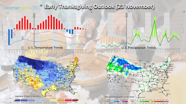
The early Thanksgiving outlook shows the very warm weather leading up to the holiday, and then a cooler few day trend which might spur some Black Friday sales.
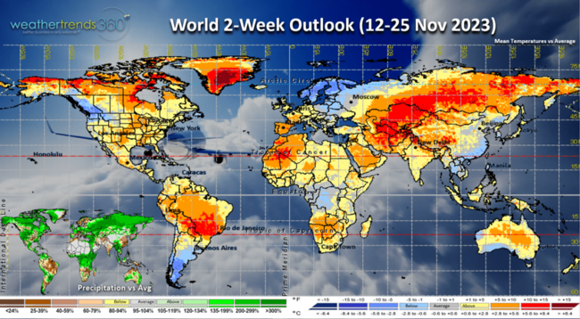
The World 2-week outlook (12-25 Nov) shows a warm and wet theme continuing for the Northern Hemisphere. This will likely transition to a cooler and much snowier pattern, especially the East Coast - Northeast as we get into middle December into middle March. wt360 expects the snowiest U.S. winter in 10 years due in part to the strong El Niño that will weaken through the Winter season.
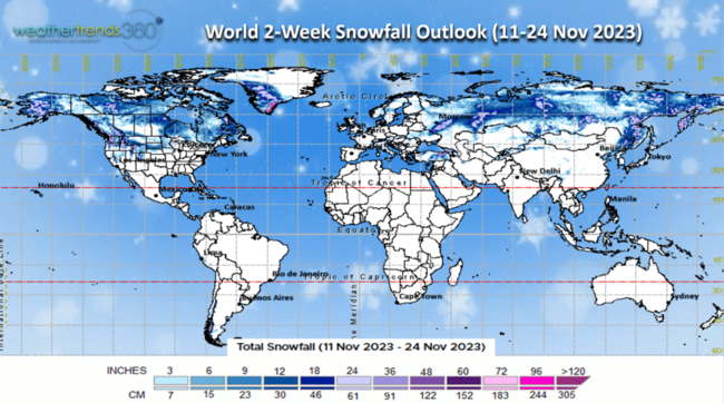
2-week World snowfall outlook (11-24 Nov) shows some 2-3'+ snowfall near Moscow, Siberia, and the Pacific Northwest U.S.
We hope you have a great week ahead, and don't forget to follow us on social media for frequent updates: Facebook, Twitter, YouTube, Pinterest and Linkedin.
- Captain Kirk out
Happy Veteran's Day 2023, we have a nice blue-sky day here at wt360 HQ in Bethlehem PA. CLICK ON IMAGES FOR A LARGER VIEW.

Another CME is headed our way with a G2 level solar storm tonight. This could lead to some auroras from Maine to Washington across the Northern tier of the U.S. November has been active on this front with auroras seen deep into the U.S. TBD if this one will be as strong as the earlier week event. Midnight local time is usually the best viewing across the northern horizon.

Solar Cycles are important as they due influence the oceans and ultimately the weather cycles. Solar Cycle #25 is weaker by historical standards but trending stronger than forecast. This, will likely make for an active aurora season this Winter. Peak likely in 2024.

Last week (5-11 Nov) across the World shows the U.S. trending +1.6F warmer than last year, warmest in 7 years and 3rd warmest of the past 38 years. Rainfall -67% drier than last year, also driest in 7 years and 7th driest of the past 38. Snowfall -93% less than a year ago, least in 7 years and 4th least in 38 years. These are very unfavorable trends for Fall seasonal merchandise sales. The U.K. showed the greatest change toward much colder weather, coldest in 4 years while India was the warmest in over 38 years. While Europe was cooler than last year, still 2nd warmest in 38 years. All adds up to soft seasonal merchandise sales.

Snow Cover this morning across the U.S. was 6.7% vs 23.9% coverage last year. 14% is typical for this time of year.

This week (12-18 Nov) prior to Thanksgiving is very unfavorable for retail seasonal sales with national temperatures trending +15.8F warmer than last year going from 2nd coldest last year to #1 warmest this year. Rainfall up +67% vs last year, wettest in 8 years and 11th wettest in 38 years. Southern California may get 1"+ rainfall. Snowfall down -99% vs last year which was exceptionally snowy. So very cold/snowy last year to warm and no snow this year will bring strong double-digit DECLINES in seasonal sales.

The 6-day snowfall outlook shows the Sierras getting their first big snow, but where people live, snowfall is down -97% vs last year and least in 7 years with only 3% of the U.S. population having snow.

Next week (19-25) Thanksgiving shows signs of a pattern change with a strong cold front invading the U.S. While national temperatures are +2.8F warmer than last year, warmest in 3 years and 9th warmest of the past 38 years, there will be a major cooling trend going into the Thanksgiving weekend. Rainfall up +94% vs last year, wettest in 9 years and 8th wettest of the past 38 years. Snowfall way up, 9.3X more than a year ago and #1 most in over 38 years.

The early Thanksgiving outlook shows the very warm weather leading up to the holiday, and then a cooler few day trend which might spur some Black Friday sales.

The World 2-week outlook (12-25 Nov) shows a warm and wet theme continuing for the Northern Hemisphere. This will likely transition to a cooler and much snowier pattern, especially the East Coast - Northeast as we get into middle December into middle March. wt360 expects the snowiest U.S. winter in 10 years due in part to the strong El Niño that will weaken through the Winter season.

2-week World snowfall outlook (11-24 Nov) shows some 2-3'+ snowfall near Moscow, Siberia, and the Pacific Northwest U.S.

We hope you have a great week ahead, and don't forget to follow us on social media for frequent updates: Facebook, Twitter, YouTube, Pinterest and Linkedin.
- Captain Kirk out