Captain's Log 11 Feb '23 Warm Feb...Colder Snowier March!
Captain's Log
11 February 2023: Happy Saturday. :)
We've been reviewing the Q4 weather trends and the year-ahead with our financial services clients and the news is OK to not so good for 2023. We always start with an assessment on the accuracy of our year-ahead information and it's tracking well. CLICK ON IMAGES FOR A LARGER VIEW.
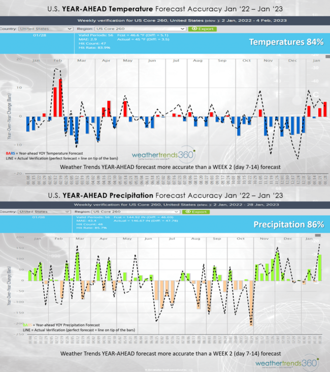
U.S. year-ahead weekly temperatures tracking at 84% capturing the colder start to Q4 but very warm finish. Rainfall tracking at 86% over the past 13 months. Get the year-ahead weather right at a very granular level and you can predict A LOT of business outcomes on seasonal category sales, store traffic and the pulse of the overall economy.
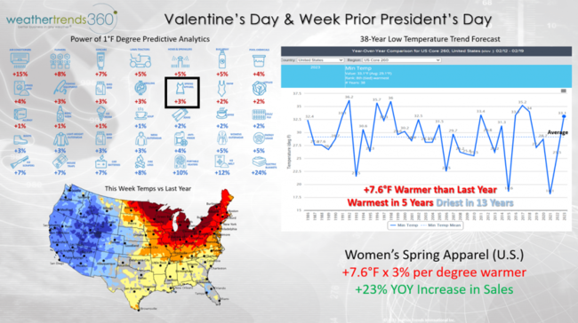
Get the weather right then you need to model sales and business outcomes to help retailers and suppliers predict every phase of their business from inventory to allocation to marketing, adverting, energy costs and more. We call it the Power of 1 Degree on how small changes in weather have a significant influence on seasonal category sales. This week is a good example of how the weather can help lift very early Spring merchandise sales and help with Winter clearance. The middle February period is the busiest of the month with the two holidays Valentine's Day and President's Day. The weather trends show the U.S. trending +7.6F warmer than a year ago and that's a boost to Women's Spring Apparel. Every 1F warmer this time of year can bring a 3% increase in sales so the simple math suggests a +23% increase in sales over last year with the milder weather. The West is better for Winter clearance sales with the colder weather.
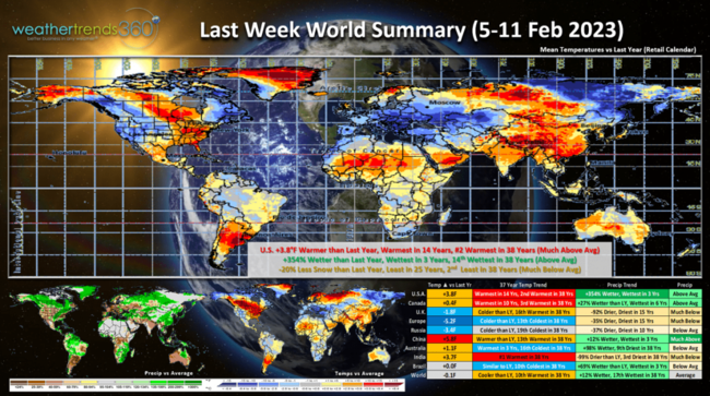
A recap of last week (5-11 Feb) around the World shows the U.S. trending +3.8F warmer than last year, warmest in 14 years and 2nd warmest of the past 38 years with much above average national temperatures, especially East. Rainfall was up +354% over last year, most in 3 years and 14th wettest of the past 38 years. Snowfall was again down -20%, least in 25 years and 2nd least in 38 years. These are good weather trends for store traffic and outdoor activities that benefit that benefit the overall economy. Canada was the 3rd warmest while Europe was quite cold.
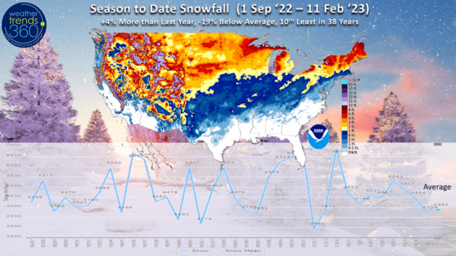
With the not so snowy February, season to date national snowfall is now only up +4% above last year, -19% below average and 10th least of the 38 years. The snow winners are the high elevations of the West and the Upper Plains. Record low totals for the coastal Northeast.
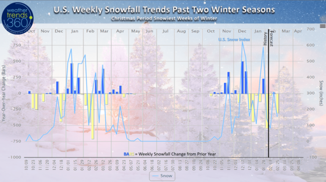
The weekly YOY snow trends across the U.S. for the past two seasons shows the very slow start last year with the snowier Jan and March compared to this year that got off to a much snowier start in Nov and December and now not much for the back half of the season. The middle December period into Christmas remains the snowiest period of the season so far, unusual for sure!
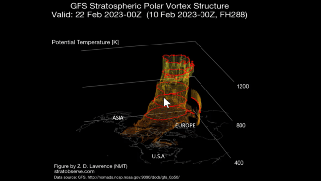
The two major culprits are the 3rd year La Nina event (not conducive to excessive snow) and the strong Polar Vortex (keeps colder air bottled up at the Arctic). If you like cold and snow there is some hope as the Polar Vortex looks to weaken once again and that will likely allow colder and snowier weather to return as we transition into March!
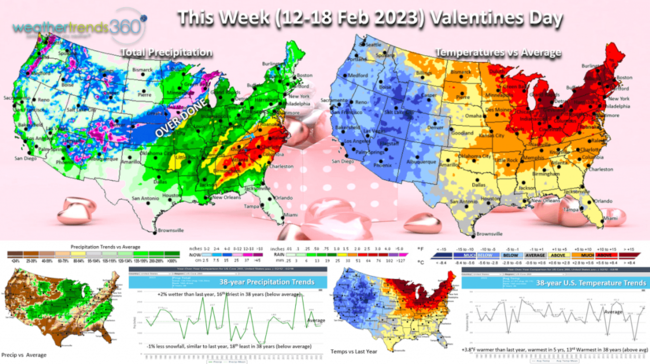
This week (12-18 Feb) has the Valentine's Day week trending +3.8F warmer than last year, warmest in 5 years and 13th warmest of the past 38 years. The same general trend of very mild East and colder West. Rainfall up +2% but still 16th driest of the past 38 years despite some heavier rain in the Southeast and a swath of heavier snow from Colorado to Wisconsin later this week.
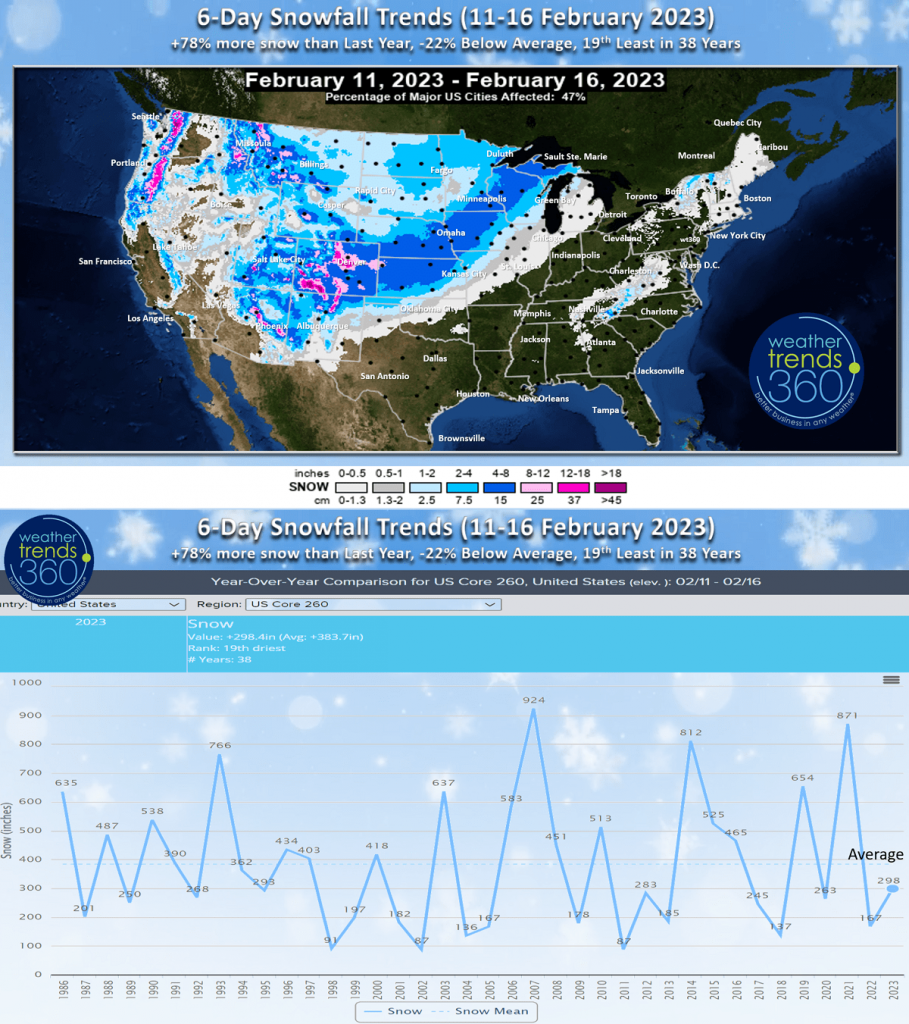 The 6-day snowfall forecast shows the moderate band of snow bringing 4-8"+ for much of the drought plagued Central Plains - good news! National snowfall for this period is +78% more than last year but still -22% below average and 19th least of the past 38 years.
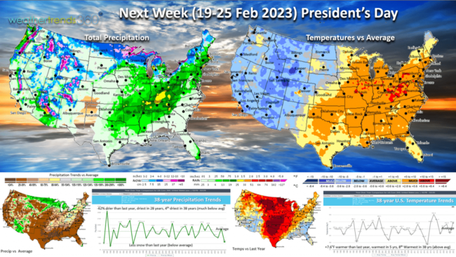
Next week (19-25 Feb) President's Day shows the same general pattern but signs of a change with a potential incursion of the Polar Vortex very late in this period into late month-early March. The week still trends +7.6F warmer than last year, warmest in 5 years and 8th warmest of the past 38 years. Rainfall down -62% and driest in 28 years, 4th driest in 38 years. Short range models have been under estimating storm systems in the week 2 period so this is probably under done as the La Niña cycle begins to collapse.
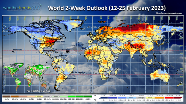
The 2-week (12-25 Feb) World Outlook shows the same general theme in the U.S. but cooling dramatically in Canada and warming in Europe.

Happy Valentine's Day to you and don't forget to follow us on social media for frequent updates: Facebook, Twitter, YouTube, Pinterest and Linkedin.
- Captain Kirk out.