Captain's Log 1 June '24 Warmer/Wetter Start to Summer
Captain's Log
1 June '24: Happy 1st Saturday of Summer! :)
https://www.youtube.com/watch?v=HQirV8sLm7A
It's the start of meteorological Summer and the 2024 hurricane season. The front half of June last year was the cool and driest in 12 years, this year the warmest in 3 years but wettest in 11 years. CLICK ON IMAGES FOR A LARGER VIEW.
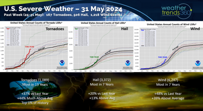
Severe weather continues to be on a near record pace adding 167 tornadoes, 506 hail events and 1,218 wind events in the past week. All categories are well above average with tornadoes the most in 13 years and in the top 1% just behind the record 2011 season.
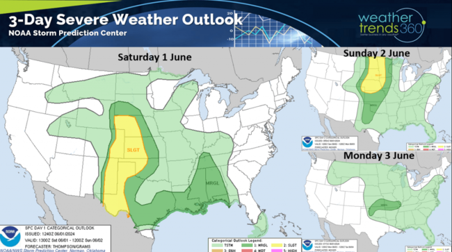
The 3-day severe weather outlook shows severe weather shifting from the Western Plains into the Northern Plains Sunday. Severe weather threats continue into the week ahead in the Heartland.
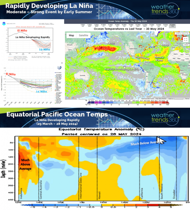
La Niña continues to rapidly develop and likely to continue through 2024 into early 2025 before transitioning to a Neutral phase in Spring 2025. Record warm water continues in the Tropical Atlantic which doesn't bode well for the 2024 hurricane season that will be very active with high threats for South Florida, Texas and much of the Caribbean.
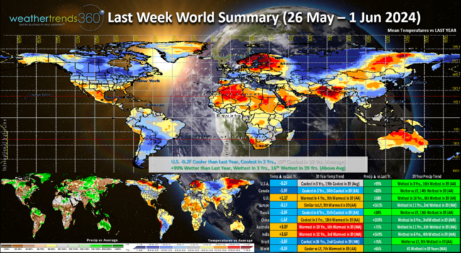
Last week (26 May - 1 Jun) across the World shows the U.S. trending -0.2F cooler than last year, coolest in 3 years and 19th coolest of the past 39 years. Rainfall was again up +99% vs last year, most in 3 years and 16th wettest of the past 39 years. Even cooler across Canada while the U.K. was warmer. Australia and India were the hot spots, but most of the World continues to be in a very wet cycle.
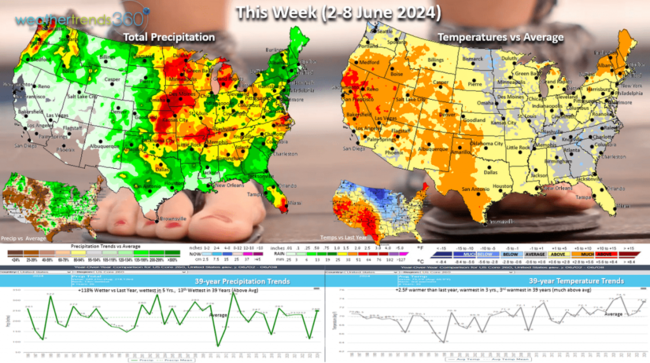
This week (2-8 June) is the start of meteorological Summer and it's getting off to a warmer but wetter start than last year's cool/dry start. The U.S. overall trends +2.5F warmer than last year, warmest in 3 years and 3rd warmest of the past 39 years. The hottest trends are in the West and Southwest and New England. Rainfall up +118% over last year, most in 5 years and 13th wettest of the past 39 years. Severe weather risk highest in the Central U.S. The warmer trends are a plus for seasonal items, but the rain continues to put a damper on demand and store traffic.
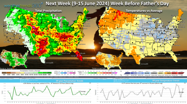
Next week (9-15 June) before Father's Day shows more of the same with the U.S. trending +3.7F warmer than last year and 6th warmest of the past 39 years. Rainfall +23% wetter than last year, wettest in 9 years and 6th wettest of the past 39 years. The most improved region for Summer seasonal sales is the West where it's both warmer and drier vs a year ago.
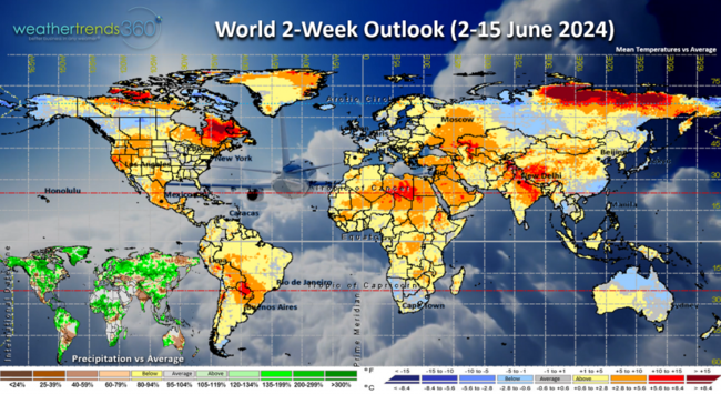
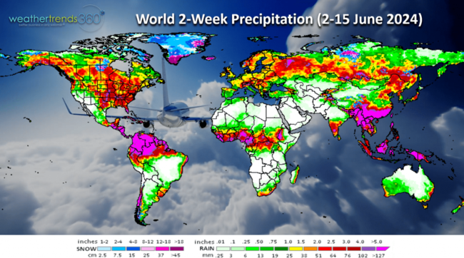
The World 2-week outlook (2-15 June) shows a general warming trend across North America, cooler in Central Europe. North America and Europe remain on the wet side.
We hope you have a great week and don't forget to follow us on social media for frequent updates: Twitter, YouTube, Pinterest and Linkedin.
Captain Kirk out.
https://www.youtube.com/watch?v=HQirV8sLm7A
It's the start of meteorological Summer and the 2024 hurricane season. The front half of June last year was the cool and driest in 12 years, this year the warmest in 3 years but wettest in 11 years. CLICK ON IMAGES FOR A LARGER VIEW.

Severe weather continues to be on a near record pace adding 167 tornadoes, 506 hail events and 1,218 wind events in the past week. All categories are well above average with tornadoes the most in 13 years and in the top 1% just behind the record 2011 season.

The 3-day severe weather outlook shows severe weather shifting from the Western Plains into the Northern Plains Sunday. Severe weather threats continue into the week ahead in the Heartland.

La Niña continues to rapidly develop and likely to continue through 2024 into early 2025 before transitioning to a Neutral phase in Spring 2025. Record warm water continues in the Tropical Atlantic which doesn't bode well for the 2024 hurricane season that will be very active with high threats for South Florida, Texas and much of the Caribbean.

Last week (26 May - 1 Jun) across the World shows the U.S. trending -0.2F cooler than last year, coolest in 3 years and 19th coolest of the past 39 years. Rainfall was again up +99% vs last year, most in 3 years and 16th wettest of the past 39 years. Even cooler across Canada while the U.K. was warmer. Australia and India were the hot spots, but most of the World continues to be in a very wet cycle.

This week (2-8 June) is the start of meteorological Summer and it's getting off to a warmer but wetter start than last year's cool/dry start. The U.S. overall trends +2.5F warmer than last year, warmest in 3 years and 3rd warmest of the past 39 years. The hottest trends are in the West and Southwest and New England. Rainfall up +118% over last year, most in 5 years and 13th wettest of the past 39 years. Severe weather risk highest in the Central U.S. The warmer trends are a plus for seasonal items, but the rain continues to put a damper on demand and store traffic.

Next week (9-15 June) before Father's Day shows more of the same with the U.S. trending +3.7F warmer than last year and 6th warmest of the past 39 years. Rainfall +23% wetter than last year, wettest in 9 years and 6th wettest of the past 39 years. The most improved region for Summer seasonal sales is the West where it's both warmer and drier vs a year ago.

The World 2-week outlook (2-15 June) shows a general warming trend across North America, cooler in Central Europe. North America and Europe remain on the wet side.

We hope you have a great week and don't forget to follow us on social media for frequent updates: Twitter, YouTube, Pinterest and Linkedin.
Captain Kirk out.