Captain's Log 1 Apr '23 Bad March - Better April
Captain's Log
1 April 2023: Happy Saturday! :)
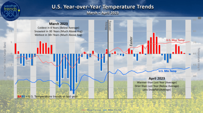
It's no joke, March 2023 (5-week retail March - 27 Feb to 1 Apr) was a very tough month for retail and seasonal sales. The month overall trended the coldest in 4 years, snowiest in 30 years and wettest in over 38 years with frequent tornadoes. CLICK ON IMAGES FOR A LARGER VIEW.
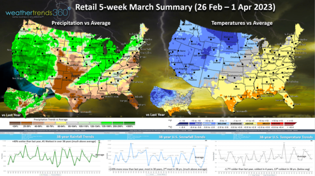
It seems like a bad joke, but snow cover across the U.S. still stands at 30% which is the most in 15 years and 2nd most in 20 years (most coverage since 2008) for this late in the season. Average is 15%.
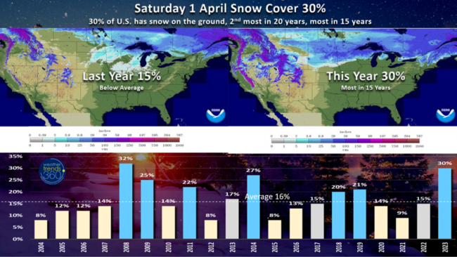
With the very snowy March, U.S. Season-to-date (1 Sep - 1 Apr) now stands as the most snow in 4 years, +22% more than last year, -4% below average and 18th least in 38 years.
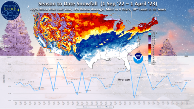
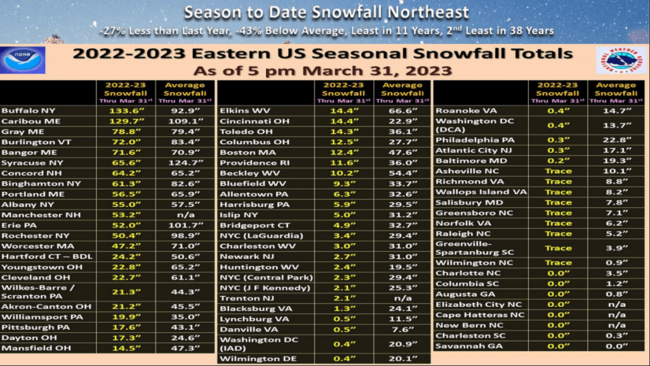
The Northeast U.S. has had the least snowfall in 11 years, 2nd least in 38 years with -27% less snow than last year and a whopping -43% below average. The top two snowy spots have been Buffal0 133.6" (most of this came in one storm early in the season) while Caribou Maine is getting very close to the top spot with 129.7".
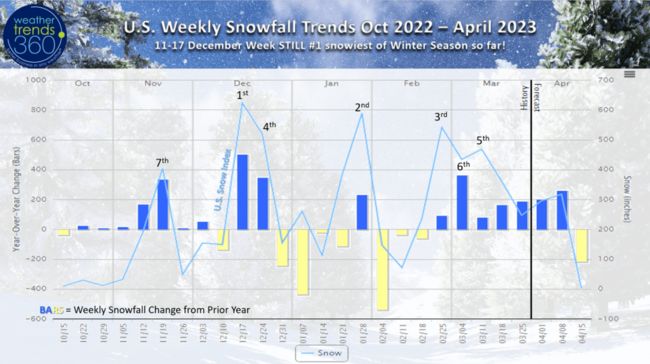
It's definitely been a snowy end to late Winter - early Spring with 7 straight weeks of snowier conditions than last year. A net negative for retail sales and store traffic.
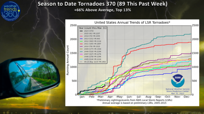
Tornadoes are also way up as expected with 370 to date which is +66% above average in the top 13% of history. Sadly many have resulted in fatalities hitting larger population centers. This severe trend likely to continue this week and the Spring season overall.
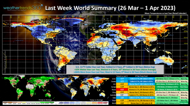
Last week (26 March - 1 April) across the World was another generally unfavorable week for seasonal sales in the U.S. which trended -0.7F colder than last year, coldest in 5 years and 8th coldest of the past 38 years. Rainfall was +32% over last year, wettest in 6 years, 10th wettest in 38 years. Snowfall was again way up +284% over last year, most in 12 years and 3rd most in 38 years. Canada was the coldest in 5 years, India the coolest in 12 years, while Russia showed the greatest change toward warmer weather.
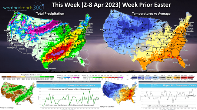
This Week (2-8 April) shows another severe weather threat in the South Central U.S. while heavier snow is still likely from the Rockies into the Upper Plains. For the U.S. overall, the week trends +1.2F warmer than last year, 19th coolest of the past 38 with near average national temperatures despite the huge difference of very cold West and warm East. Rainfall -11% drier than last year but still 15th wettest in 38 years. Snowfall up a whopping +636% and most in 26 years for the start of April. These remain generally unfavorable trends for the week prior to Easter.
April overall is likely to be better than last year and better than March. April overall looks to trend warmer, drier and less snowy than last year with near average conditions in all three metrics. A better trend for seasonal merchandise sales to close out the retail Q1 (Feb - Apr).
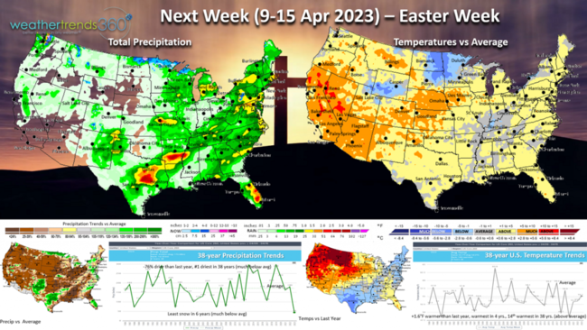
Next week (9-15 Apr) Easter Week trends +1.6F warmer than last year, warmest in 4 years and 14th warmest of the past 38 years. The big warm up in the West should bring a good surge in Spring seasonal merchandise sales after weeks of colder weather. Rainfall down -76% (this is probably over done) and #1 driest of the past 38 years. With less contrast between cold in the West and warm in the Southeast, the battle ground for severe weather should be diminished for a bit. Snowfall likely the least in 6 years - just about to stop saying that 4-letter word.
The 2-week World outlook (2-15 Apr) shows cooler trends for Europe with some moderation toward milder weather in the U.S.

We hope you have a great week ahead, and don't forget to follow us on social media for frequent updates: Facebook, Twitter, YouTube, Pinterest and Linkedin.
- Captain Kirk out.
It's no joke, March 2023 (5-week retail March - 27 Feb to 1 Apr) was a very tough month for retail and seasonal sales. The month overall trended the coldest in 4 years, snowiest in 30 years and wettest in over 38 years with frequent tornadoes. CLICK ON IMAGES FOR A LARGER VIEW.

It seems like a bad joke, but snow cover across the U.S. still stands at 30% which is the most in 15 years and 2nd most in 20 years (most coverage since 2008) for this late in the season. Average is 15%.

With the very snowy March, U.S. Season-to-date (1 Sep - 1 Apr) now stands as the most snow in 4 years, +22% more than last year, -4% below average and 18th least in 38 years.

The Northeast U.S. has had the least snowfall in 11 years, 2nd least in 38 years with -27% less snow than last year and a whopping -43% below average. The top two snowy spots have been Buffal0 133.6" (most of this came in one storm early in the season) while Caribou Maine is getting very close to the top spot with 129.7".

It's definitely been a snowy end to late Winter - early Spring with 7 straight weeks of snowier conditions than last year. A net negative for retail sales and store traffic.

Tornadoes are also way up as expected with 370 to date which is +66% above average in the top 13% of history. Sadly many have resulted in fatalities hitting larger population centers. This severe trend likely to continue this week and the Spring season overall.

Last week (26 March - 1 April) across the World was another generally unfavorable week for seasonal sales in the U.S. which trended -0.7F colder than last year, coldest in 5 years and 8th coldest of the past 38 years. Rainfall was +32% over last year, wettest in 6 years, 10th wettest in 38 years. Snowfall was again way up +284% over last year, most in 12 years and 3rd most in 38 years. Canada was the coldest in 5 years, India the coolest in 12 years, while Russia showed the greatest change toward warmer weather.

This Week (2-8 April) shows another severe weather threat in the South Central U.S. while heavier snow is still likely from the Rockies into the Upper Plains. For the U.S. overall, the week trends +1.2F warmer than last year, 19th coolest of the past 38 with near average national temperatures despite the huge difference of very cold West and warm East. Rainfall -11% drier than last year but still 15th wettest in 38 years. Snowfall up a whopping +636% and most in 26 years for the start of April. These remain generally unfavorable trends for the week prior to Easter.

April overall is likely to be better than last year and better than March. April overall looks to trend warmer, drier and less snowy than last year with near average conditions in all three metrics. A better trend for seasonal merchandise sales to close out the retail Q1 (Feb - Apr).

Next week (9-15 Apr) Easter Week trends +1.6F warmer than last year, warmest in 4 years and 14th warmest of the past 38 years. The big warm up in the West should bring a good surge in Spring seasonal merchandise sales after weeks of colder weather. Rainfall down -76% (this is probably over done) and #1 driest of the past 38 years. With less contrast between cold in the West and warm in the Southeast, the battle ground for severe weather should be diminished for a bit. Snowfall likely the least in 6 years - just about to stop saying that 4-letter word.

The 2-week World outlook (2-15 Apr) shows cooler trends for Europe with some moderation toward milder weather in the U.S.

We hope you have a great week ahead, and don't forget to follow us on social media for frequent updates: Facebook, Twitter, YouTube, Pinterest and Linkedin.
- Captain Kirk out.