Captain's Log 03 Jul '23 Happy Independence Day!
Captain's Log
03 July '23: Happy Independence Day Week! Hope you are having a safe and enjoyable holiday.
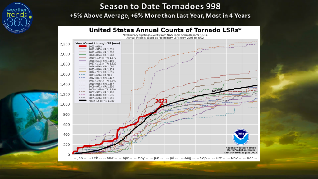
The tornado count increased a few ticks last week with a couple of tornadoes reported in the Midwest, High Plains, and even a couple not too far from WeatherTrends360's headquarters. This brings the season-to-date tally to +5% above average and +6% above last year with 998 year-to-date. We're likely to surpass the 1,000 mark this week as more severe weather is possible in the Mid-Atlantic and across portions of the North Central U.S. as an active weather pattern continues.
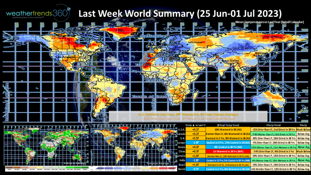
Last Week (25 June-01 July) across the World shows a warm week here in the U.S. trending similar to last year but the 10th warmest in 38 years. Rainfall was down 31% from last year. The South Central U.S. continued to see some very hot weather which crept into neighboring southern states and eventually the Southwest by the latter part of the week. Canada was the 6th warmest in 38 years with very poor air quality striking the major cities in Ontario and Ottawa once again due to wildfires farther north. Some of that wildfire smoke made it into portions of the U.S. Midwest, Great Lakes, Ohio Valley, and Mid-Atlantic.
No new tropical systems in the Atlantic Basin to speak of early this week, but the Eastern Pacific ocean is likely to see a system develop this week several hundred miles off the coast of southern Mexico.
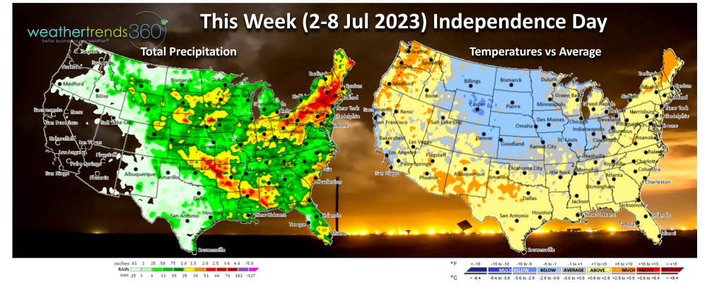
This Week (02-08 Jul) shows the U.S. trending cooler than last year but the 11th warmest in 38 years. Cooler temperatures should move into the North Central U.S. and even parts of the South could see temperatures relax from the previous week's extreme heat, but it remains fairly hot. Warmer up and down the West Coast and drier. In the Northeast we'll continue to deal with near-daily shower and thunderstorm chances, some of which could be severe. Thankfully, some much needed rain has arrived in the Corn Belt, although a bit excessive in parts of the Midwest on Sunday with anywhere from 2 to 9'' of rain falling in and around the Chicago metro area causing flash flooding. There will be more chances of rain in the Corn Belt through the upcoming week.
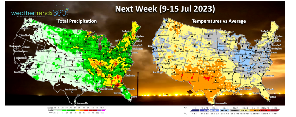
Next Week (09-15 July) shows the U.S. trending -0.3F cooler than last year but the 13th warmest in 38 years and precipitation down -26% from last year. The best chance for rain will be across the eastern half of the nation. The West turns generally drier, although the monsoon could start to kick up some showers and thunderstorms in the Desert Southwest.
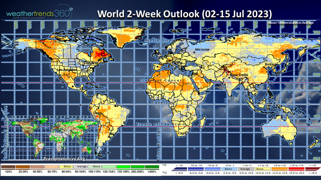
The World 2-week outlook (02-15 July) shows warmer trends across the western and portions of the southern U.S. but some cooler spots around the North Central U.S., Great Lakes, and Ohio Valley. Europe should be above average as well as China.

The tornado count increased a few ticks last week with a couple of tornadoes reported in the Midwest, High Plains, and even a couple not too far from WeatherTrends360's headquarters. This brings the season-to-date tally to +5% above average and +6% above last year with 998 year-to-date. We're likely to surpass the 1,000 mark this week as more severe weather is possible in the Mid-Atlantic and across portions of the North Central U.S. as an active weather pattern continues.

Last Week (25 June-01 July) across the World shows a warm week here in the U.S. trending similar to last year but the 10th warmest in 38 years. Rainfall was down 31% from last year. The South Central U.S. continued to see some very hot weather which crept into neighboring southern states and eventually the Southwest by the latter part of the week. Canada was the 6th warmest in 38 years with very poor air quality striking the major cities in Ontario and Ottawa once again due to wildfires farther north. Some of that wildfire smoke made it into portions of the U.S. Midwest, Great Lakes, Ohio Valley, and Mid-Atlantic.

No new tropical systems in the Atlantic Basin to speak of early this week, but the Eastern Pacific ocean is likely to see a system develop this week several hundred miles off the coast of southern Mexico.
This Week (02-08 Jul) shows the U.S. trending cooler than last year but the 11th warmest in 38 years. Cooler temperatures should move into the North Central U.S. and even parts of the South could see temperatures relax from the previous week's extreme heat, but it remains fairly hot. Warmer up and down the West Coast and drier. In the Northeast we'll continue to deal with near-daily shower and thunderstorm chances, some of which could be severe. Thankfully, some much needed rain has arrived in the Corn Belt, although a bit excessive in parts of the Midwest on Sunday with anywhere from 2 to 9'' of rain falling in and around the Chicago metro area causing flash flooding. There will be more chances of rain in the Corn Belt through the upcoming week.

Next Week (09-15 July) shows the U.S. trending -0.3F cooler than last year but the 13th warmest in 38 years and precipitation down -26% from last year. The best chance for rain will be across the eastern half of the nation. The West turns generally drier, although the monsoon could start to kick up some showers and thunderstorms in the Desert Southwest.

The World 2-week outlook (02-15 July) shows warmer trends across the western and portions of the southern U.S. but some cooler spots around the North Central U.S., Great Lakes, and Ohio Valley. Europe should be above average as well as China.
