Captain's Blog 8 Feb '25 Coldest & Snowiest February in 4 Years
Captain's Log
8 Feb '25: Happy Saturday! :)
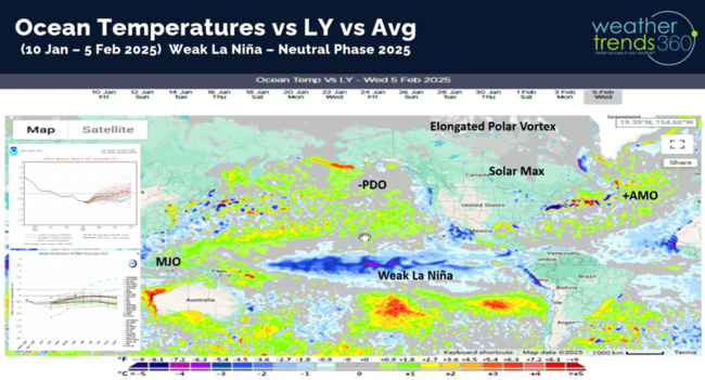
La Niña is likely peaking and then a gradual weakening for a neutral slightly negative ENSO phase for the rest of 2025. CLICK ON IMAGES FOR A LARGER VIEW.
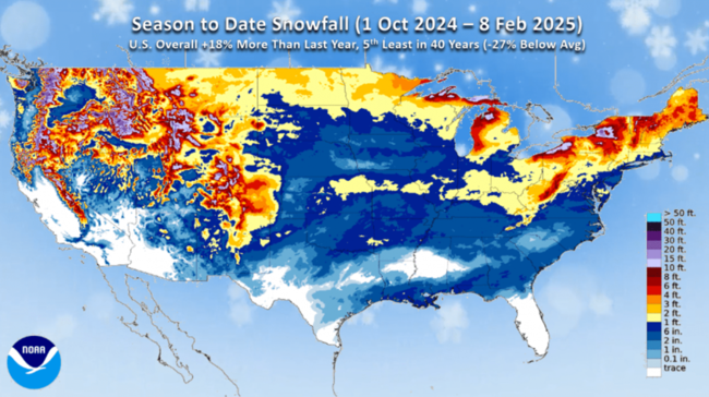
Season-to-date snowfall across the U.S. is up +18% over last year, but still 5th least in 40 years nationally. This will increase dramatically with a snowy February.
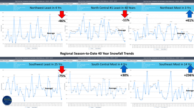
Regional snowfall trends show the North Central U.S. with the least snow in over 40 years, least in 25 years in the Southwest, least in 4 years Northwest, but the most in 4 years in the South Central, most in 3 years Northeast (this will increase), and the most in 14 years for the Southeast.
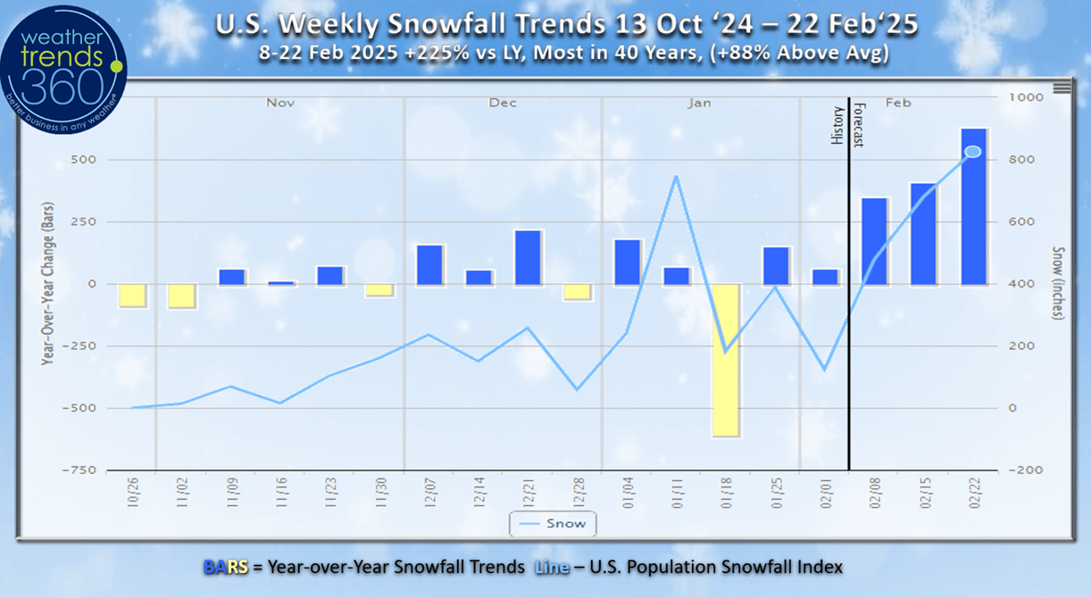
The season-to-date weekly U.S. snowfall trends show the peak snowy week so far this Winter was the 5th-11th January, but it appears the snowiest week of Winter will now happen in middle February. The next 2-weeks show the most snow in over 4 years for the U.S. trending +225% more than last year.

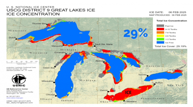
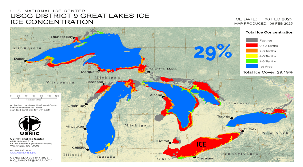
Ice cover on the Great Lakes expanded and now up to 29% of the lakes covered in ice. Lake Erie (shallow lake) is now nearly completely covered in ice which helps to shut down the Lake Effect snow machine downwind.
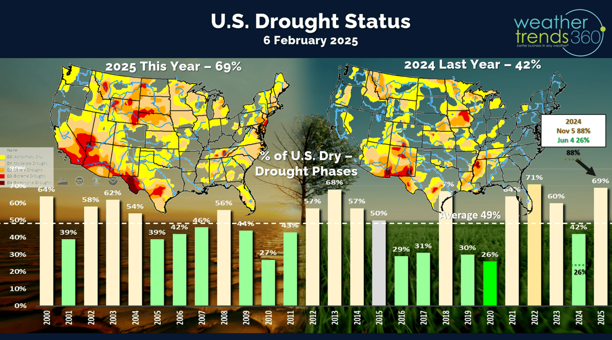
Drought continues to expand with 69% of the U.S. in dry to drought phases as of 6 February. Last year only 42% of the U.S. was dry. Drought will expand West, North and Northeast in 2025.

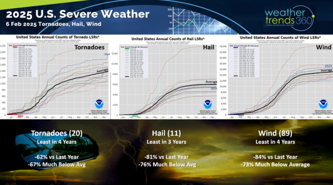
The Severe Weather season is off to a much slower start than last year with tornadoes down -62%, hail down -81% and wind down -84%. This will be a much less active severe weather season in 2025 vs last year, but hail likely to be up with a much colder Spring.
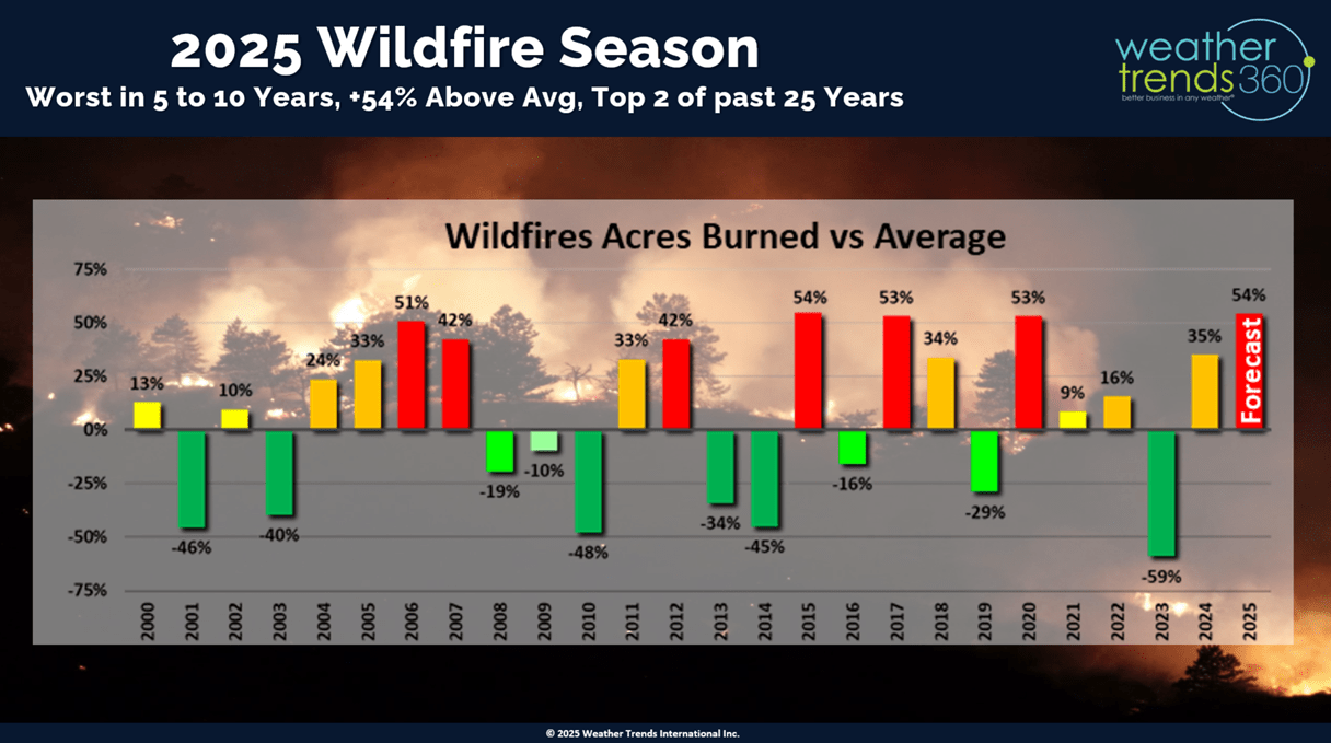
The big theme in 2025 will be one of the worst wildfire season in 10 years with acres burned likely to be 54% above average compared to 35% above average last year and -59% below average (least in 30 years) back in 2023.

Last week (2-8 Feb) across the World shows the U.S. trending -2.3F colder than last year but still 6th warmest of the past 40 years. Rainfall was -25% drier than last year and 10th driest of the past 40 years, while snowfall was up +267%, most in 3 years and 18th most of the past 40 years. This time of year, warmer and drier weather is better for store traffic and the overall economy. This will be a very out-of-sync weather pattern for the front half of 2025 leading to weaker than expected retail and seasonal sales.
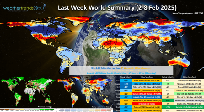
It was much colder across Canada with a very significant -17.9F colder YOY trend. China coldest in 7 years, while India was the #1 warmest in 40 years. Beneficial rains across Brazil, still dry in Eastern Brazil resulting in a huge surge in coffee prices.
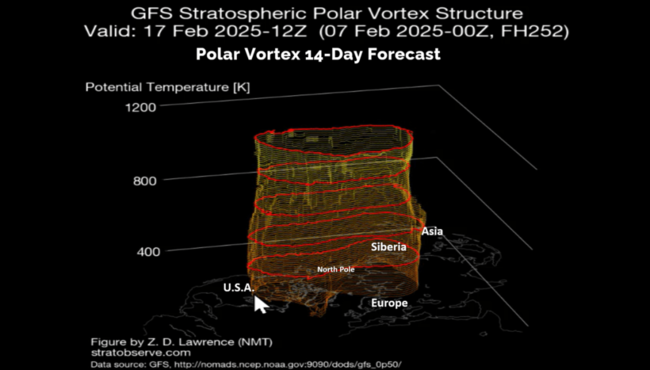
The Polar Vortex is once again elongated which allows cold air to spill from Siberia across the North Pole into North America with a cross polar vortex flow pattern. A dramatically different pattern than February the past few years which were warm in the U.S.
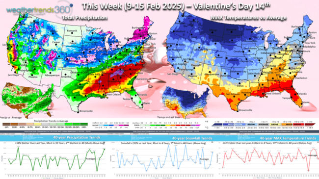
This week (9-15 Feb) Valentine's Day starts to show the Polar Vortex invading the Northern tier of the U.S. which trends -8.2F colder than last year, coldest in 4 years and 13th coldest of the past 40 years. Snowfall +150% more than last year, most in 4 years and 7th most of the past 40 years with a very active storm pattern. Rainfall up +34% vs LY, most in 35 years and 2nd most in 40 years. These are favorable trends for the consumable categories like hot beverages, hot cereals, snow melt, auto batteries, but a negative for overall store traffic.

The 6-day snowfall outlook (8-13Feb) shows the first couple storms impacting the U.S., but there are several behind these well into late February. U.S. snowfall +329% more than last year, most in 11 years, 4th most in 40 years with 68% of the U.S. getting some snow.
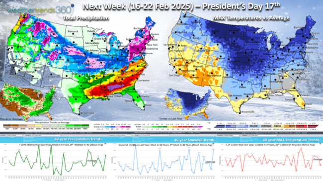
Next week (16-22 Feb) President's Day shows the cold expanding East with the U.S. trending -7.2F colder than last year, coldest in 4 years and 10th coldest of the past 40 years. Snowfall again way up +321% over LY, most in 10 years and 4th most in 40 years, while rainfall is also up +139%, most in 6 years and 8th wettest of the past 40 years. These are very negative trends for store traffic and retail sales. Seasonal items on clearance will continue to do well. The West turns warmer and much drier.
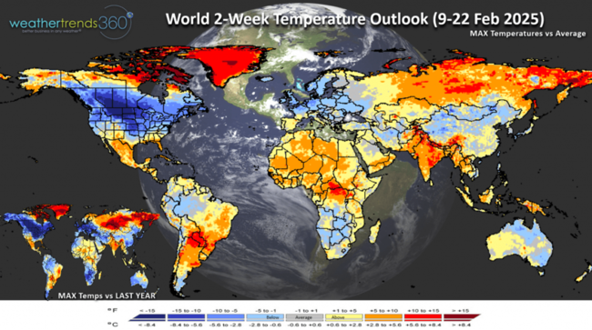
The World 2-week (9-22 Feb) temperature outlook shows the heart of the cold in Canada and the U.S. and some in Europe as well.

The World 2-week precipitation outlook shows a very stormy U.S. pattern. Dry continues across Eastern Brazil with the biggest impact to Coffee crops.
Have a great week ahead and don't forget to follow us on social media for frequent updates: Facebook, Twitter, YouTube, Pinterest and Linkedin.
- Captain Kirk out
La Niña is likely peaking and then a gradual weakening for a neutral slightly negative ENSO phase for the rest of 2025. CLICK ON IMAGES FOR A LARGER VIEW.

Season-to-date snowfall across the U.S. is up +18% over last year, but still 5th least in 40 years nationally. This will increase dramatically with a snowy February.

Regional snowfall trends show the North Central U.S. with the least snow in over 40 years, least in 25 years in the Southwest, least in 4 years Northwest, but the most in 4 years in the South Central, most in 3 years Northeast (this will increase), and the most in 14 years for the Southeast.

The season-to-date weekly U.S. snowfall trends show the peak snowy week so far this Winter was the 5th-11th January, but it appears the snowiest week of Winter will now happen in middle February. The next 2-weeks show the most snow in over 4 years for the U.S. trending +225% more than last year.
Ice cover on the Great Lakes expanded and now up to 29% of the lakes covered in ice. Lake Erie (shallow lake) is now nearly completely covered in ice which helps to shut down the Lake Effect snow machine downwind.
Drought continues to expand with 69% of the U.S. in dry to drought phases as of 6 February. Last year only 42% of the U.S. was dry. Drought will expand West, North and Northeast in 2025.
The Severe Weather season is off to a much slower start than last year with tornadoes down -62%, hail down -81% and wind down -84%. This will be a much less active severe weather season in 2025 vs last year, but hail likely to be up with a much colder Spring.

The big theme in 2025 will be one of the worst wildfire season in 10 years with acres burned likely to be 54% above average compared to 35% above average last year and -59% below average (least in 30 years) back in 2023.
Last week (2-8 Feb) across the World shows the U.S. trending -2.3F colder than last year but still 6th warmest of the past 40 years. Rainfall was -25% drier than last year and 10th driest of the past 40 years, while snowfall was up +267%, most in 3 years and 18th most of the past 40 years. This time of year, warmer and drier weather is better for store traffic and the overall economy. This will be a very out-of-sync weather pattern for the front half of 2025 leading to weaker than expected retail and seasonal sales.
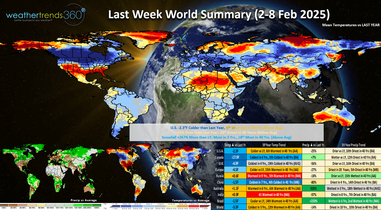
It was much colder across Canada with a very significant -17.9F colder YOY trend. China coldest in 7 years, while India was the #1 warmest in 40 years. Beneficial rains across Brazil, still dry in Eastern Brazil resulting in a huge surge in coffee prices.

The Polar Vortex is once again elongated which allows cold air to spill from Siberia across the North Pole into North America with a cross polar vortex flow pattern. A dramatically different pattern than February the past few years which were warm in the U.S.
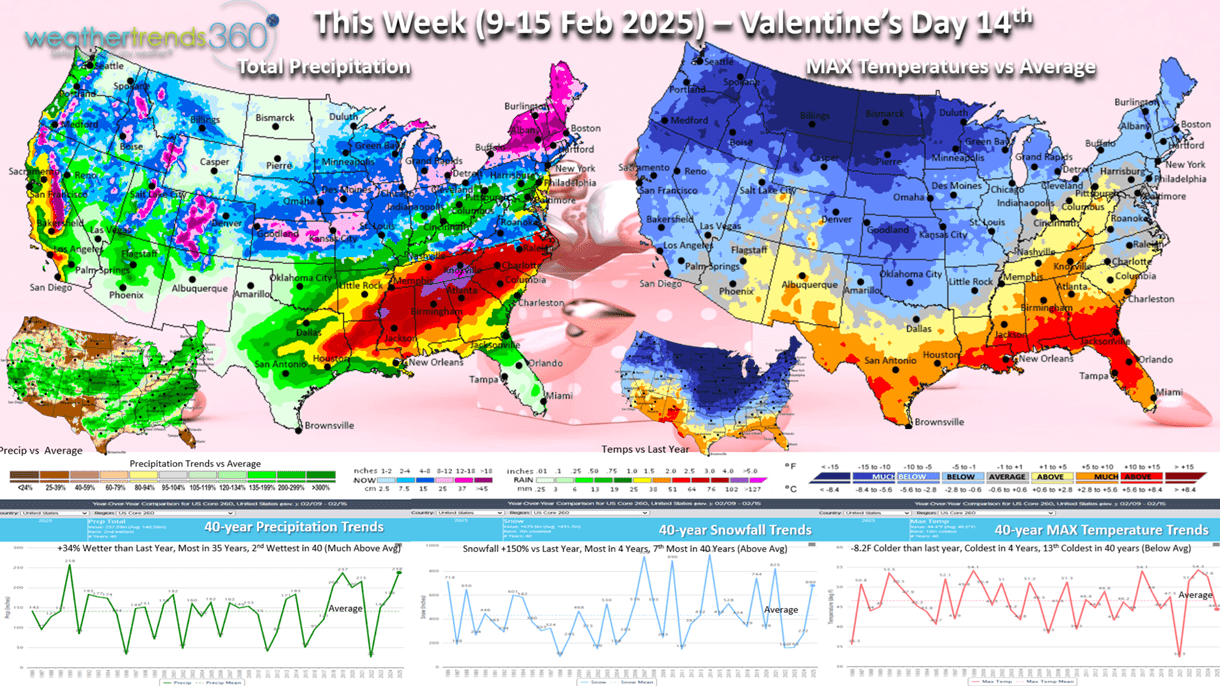
This week (9-15 Feb) Valentine's Day starts to show the Polar Vortex invading the Northern tier of the U.S. which trends -8.2F colder than last year, coldest in 4 years and 13th coldest of the past 40 years. Snowfall +150% more than last year, most in 4 years and 7th most of the past 40 years with a very active storm pattern. Rainfall up +34% vs LY, most in 35 years and 2nd most in 40 years. These are favorable trends for the consumable categories like hot beverages, hot cereals, snow melt, auto batteries, but a negative for overall store traffic.
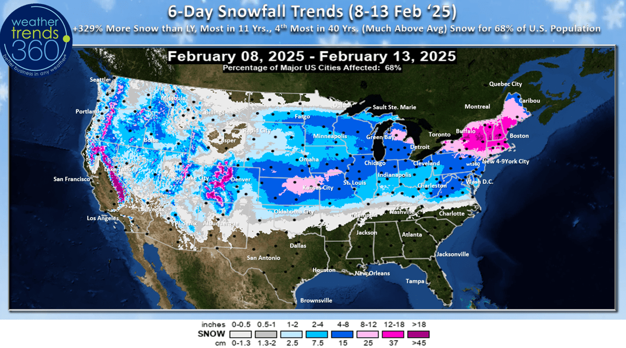
The 6-day snowfall outlook (8-13Feb) shows the first couple storms impacting the U.S., but there are several behind these well into late February. U.S. snowfall +329% more than last year, most in 11 years, 4th most in 40 years with 68% of the U.S. getting some snow.

Next week (16-22 Feb) President's Day shows the cold expanding East with the U.S. trending -7.2F colder than last year, coldest in 4 years and 10th coldest of the past 40 years. Snowfall again way up +321% over LY, most in 10 years and 4th most in 40 years, while rainfall is also up +139%, most in 6 years and 8th wettest of the past 40 years. These are very negative trends for store traffic and retail sales. Seasonal items on clearance will continue to do well. The West turns warmer and much drier.

The World 2-week (9-22 Feb) temperature outlook shows the heart of the cold in Canada and the U.S. and some in Europe as well.
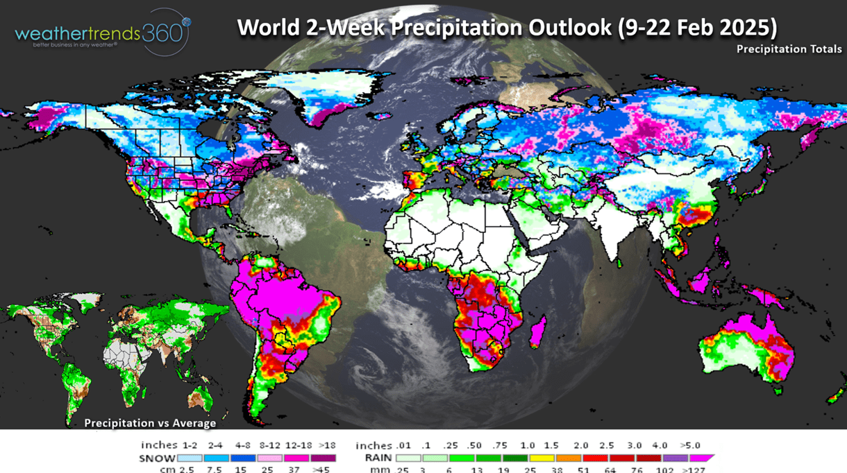
The World 2-week precipitation outlook shows a very stormy U.S. pattern. Dry continues across Eastern Brazil with the biggest impact to Coffee crops.
Have a great week ahead and don't forget to follow us on social media for frequent updates: Facebook, Twitter, YouTube, Pinterest and Linkedin.
- Captain Kirk out