Captain's Blog 7 Sep '24 Cold/Wet to Warm/Dry - Tropics Coming to Life
Captain's Log
7 Sep '24: Happy Saturday! :)
https://www.youtube.com/watch?v=kjxO-58ubSQ
We hope you're enjoying these last two weeks of Summer, Fall arrives 22 September Sunday 8:44am EDT. CLICK ON IMAGES FOR A LARGER VIEW

We did a fun FOX26 Houston TV segment live this past week talking about the Hurricane season coming to life, wildfires worst in 10 years next year and some of our 2025 outlook. VIDEO

We are nearing the peak of the hurricane season, but that still means we have 84 days left in what will become a very active back half of the core season. 5 named storms to date, 2 more likely in the week ahead as the unfavorable MJO cycle turns much more favorable for tropical development.
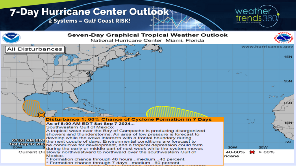 The National Hurricane Center is monitoring two areas that are likely to become named storms with yet another threat for Texas. More flooding is possible for Houston.

The 14-day storm track shows the highest risk areas in the near term are Texas and the USVI-Puerto Rico.
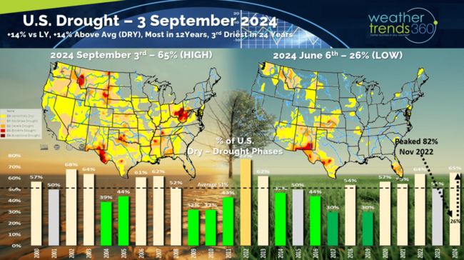
Even though La Niña hasn't been officially declared yet, the weather pattern is clearly responding to this oceanic cycle change as drought begins to expand in the U.S. Drought had plummeted to just 26% of the U.S. in early June and already back to 65% of the country in dry to drought phases, most in 12 years. This will be a theme for 2025.

The Ocean temperatures vs last year show huge changes all over the world with La Niña very evident in the Equatorial Pacific.
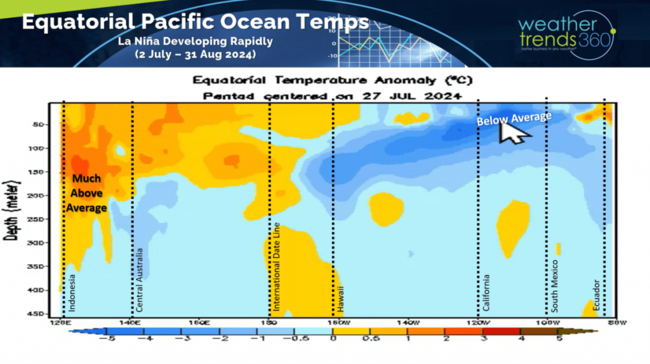
But the sub-surface ocean temperatures already show warmer than average water temperatures below this surface La Nina, so it's likely to be a short-lived event. WT360 expects a Neutral phase by late Spring 2025 but lingering drought conditions and a severe wildfire season well into 2025.

Models continue to show a weak to moderate La Nina transitioning quickly to a Neutral phase by Spring.

This Oceanic Cycle is just one of many that we track and forecast when making our year-ahead forecasts.

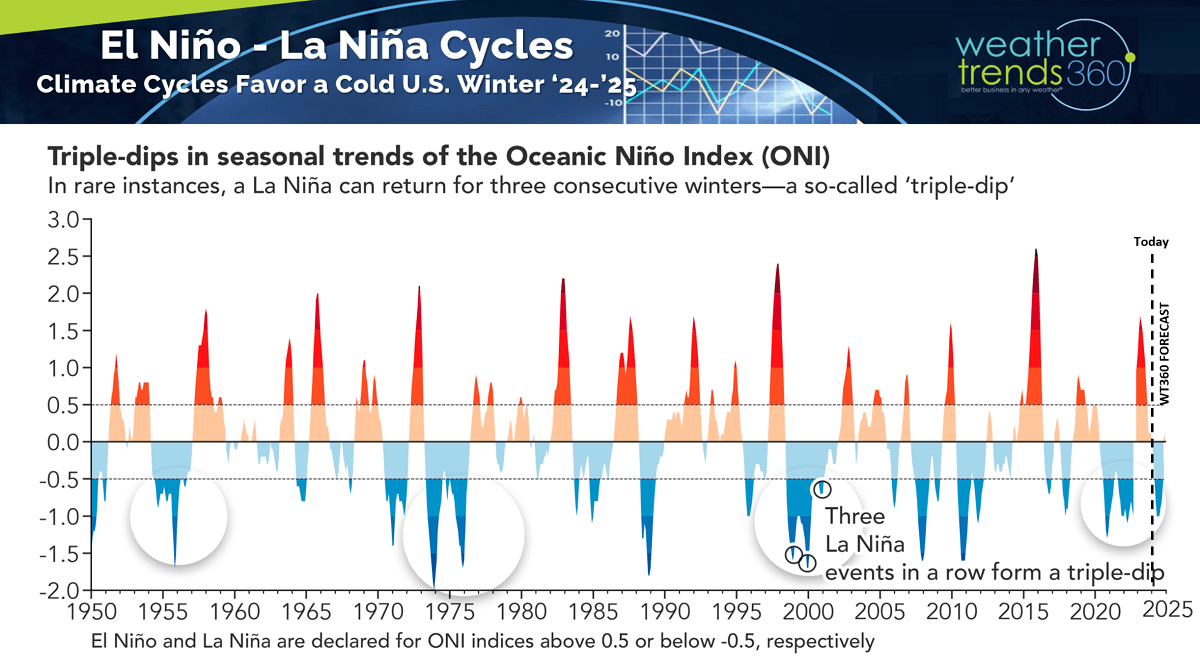
It's important to note that EVERY La Nina is different, so this is just one of dozens of factors that influence the weather patterns. But all signs suggest a much colder Winter ahead in the U.S., especially from the Midwest to the Northeast.
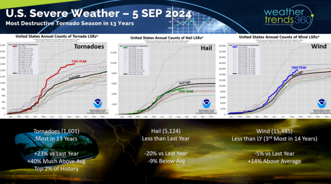
While the Severe Weather season is winding down, it was a very active year for tornadoes with the most in 13 years, top 2% of history, +23% more than last year, +40% above average with 1,601 events. Ironically hail was down -20% vs last year and -6% below average, both trends were predicted a year-ahead by WT360.
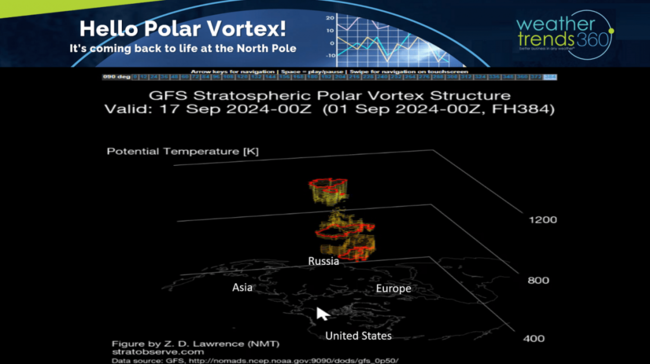
Look what's coming back to life...THE NH POLAR VORTEX! The Polar Vortex mostly disappears during the Summer but reemerges each Fall. Short range models show it starting to redevelop in middle September. WT360 expects a weaker Polar Vortex this year which allows for more frequent cold snaps across North America during Winter.

Last Week (1-7 Sep) across the World shows the U.S. trending -4F colder than last year, coldest in 7 years and 17th coldest of the past 39 with below average national temperatures. It was also +96% wetter than a year ago, 19th wettest of the past 39. These are very favorable trends for Back2School and early Fall categories where colder/wetter weather brings stronger seasonal sales. The U.S. was one of the most favorable regions for seasonal sales anywhere in the World.
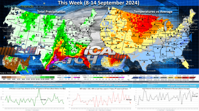
This week (8-14 Sep) shows the heatwave in the Northwest moving into the Central Plains with the cooler weather pushing to the South Central and Southeast U.S. Very likely we will get a tropical named storm or even a hurricane threatening the Gulf Coast region this week. Southeast TX can't handle any more rain, so flooding will again be the biggest threat. Overall national temperatures trend +0.2F warmer than a year ago but hot 90F days are still down -45% and least in 7 years. Rainfall down -37% nationally, but not so for the Gulf Coast region.
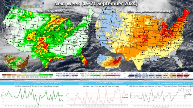
Next week (15-21 Sep) shows a major cool down for the Pacific Northwest with heat building into the Northeast. U.S. overall trends +0.4F warmer than last year, warmest in 6 years and 2nd warmest in 39 years. Rainfall is down -15% vs last year and well below average, so these are very unfavorable trends for retail seasonal merchandise sales. Tropics need to be watched as the cycles become much more favorable for rapid development. The USVI and Puerto Rico areas appear the highest risk during this middle September period.

The World 2-week outlook (8-21 Sep) shows the warming trend in the U.S. and Eastern Europe. Unfavorable for Fall merchandise, but a benefit to cold beverage categories.

World rainfall continues to show the very wet conditions across Africa, a sign that there will be plenty of tropical systems heading out into the Atlantic in the months ahead.
Have a great week ahead, and don't forget to follow us on social media for frequent updates: Facebook, Twitter, YouTube, Pinterest and Linkedin.
- Captain Kirk out.
https://www.youtube.com/watch?v=kjxO-58ubSQ
We hope you're enjoying these last two weeks of Summer, Fall arrives 22 September Sunday 8:44am EDT. CLICK ON IMAGES FOR A LARGER VIEW

We did a fun FOX26 Houston TV segment live this past week talking about the Hurricane season coming to life, wildfires worst in 10 years next year and some of our 2025 outlook. VIDEO
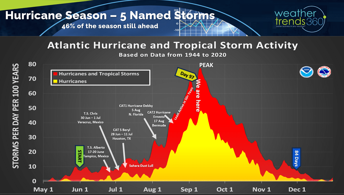
We are nearing the peak of the hurricane season, but that still means we have 84 days left in what will become a very active back half of the core season. 5 named storms to date, 2 more likely in the week ahead as the unfavorable MJO cycle turns much more favorable for tropical development.
The National Hurricane Center is monitoring two areas that are likely to become named storms with yet another threat for Texas. More flooding is possible for Houston.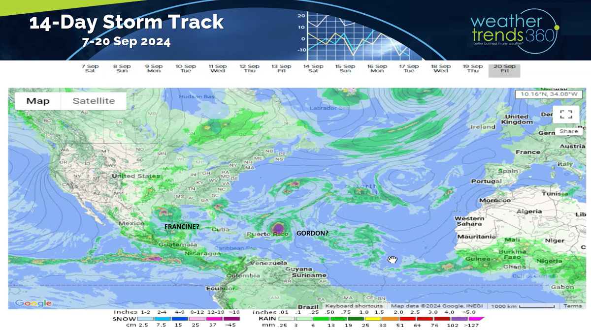
The 14-day storm track shows the highest risk areas in the near term are Texas and the USVI-Puerto Rico.

Even though La Niña hasn't been officially declared yet, the weather pattern is clearly responding to this oceanic cycle change as drought begins to expand in the U.S. Drought had plummeted to just 26% of the U.S. in early June and already back to 65% of the country in dry to drought phases, most in 12 years. This will be a theme for 2025.
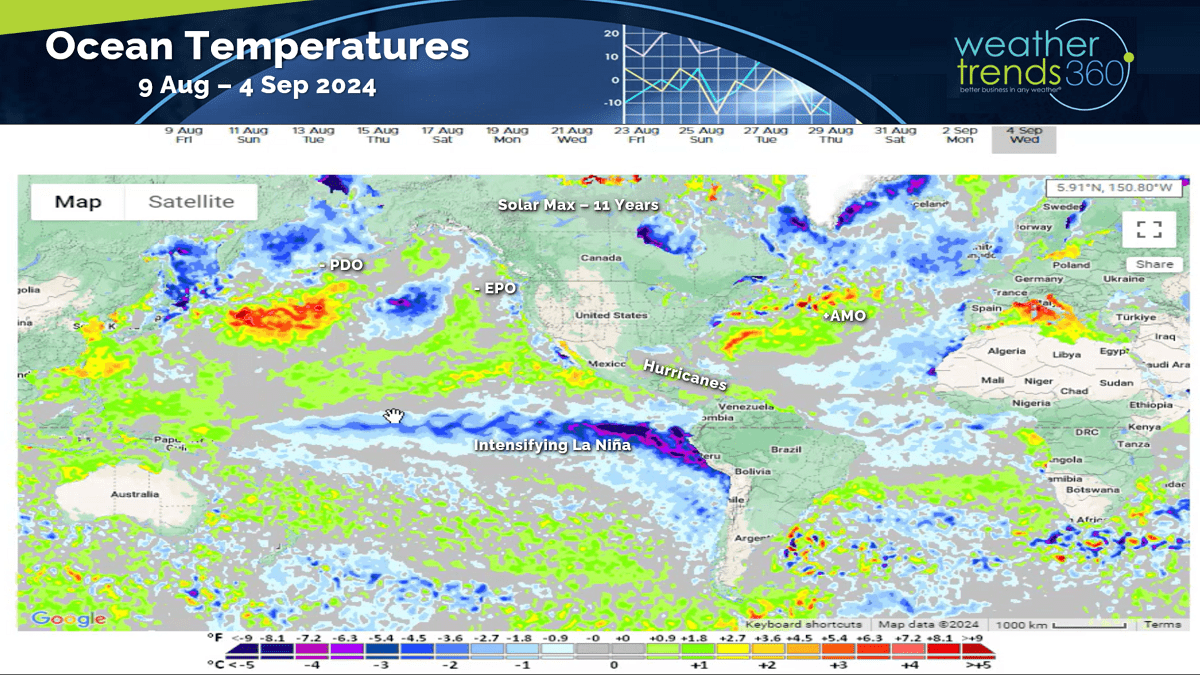
The Ocean temperatures vs last year show huge changes all over the world with La Niña very evident in the Equatorial Pacific.

But the sub-surface ocean temperatures already show warmer than average water temperatures below this surface La Nina, so it's likely to be a short-lived event. WT360 expects a Neutral phase by late Spring 2025 but lingering drought conditions and a severe wildfire season well into 2025.
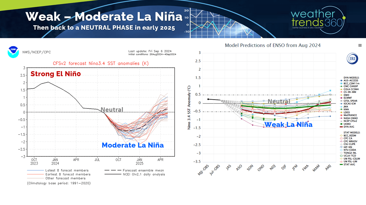
Models continue to show a weak to moderate La Nina transitioning quickly to a Neutral phase by Spring.
This Oceanic Cycle is just one of many that we track and forecast when making our year-ahead forecasts.
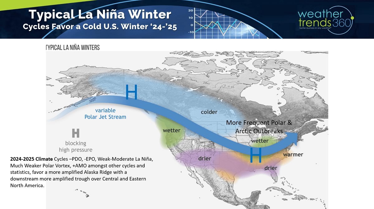
It's important to note that EVERY La Nina is different, so this is just one of dozens of factors that influence the weather patterns. But all signs suggest a much colder Winter ahead in the U.S., especially from the Midwest to the Northeast.

While the Severe Weather season is winding down, it was a very active year for tornadoes with the most in 13 years, top 2% of history, +23% more than last year, +40% above average with 1,601 events. Ironically hail was down -20% vs last year and -6% below average, both trends were predicted a year-ahead by WT360.
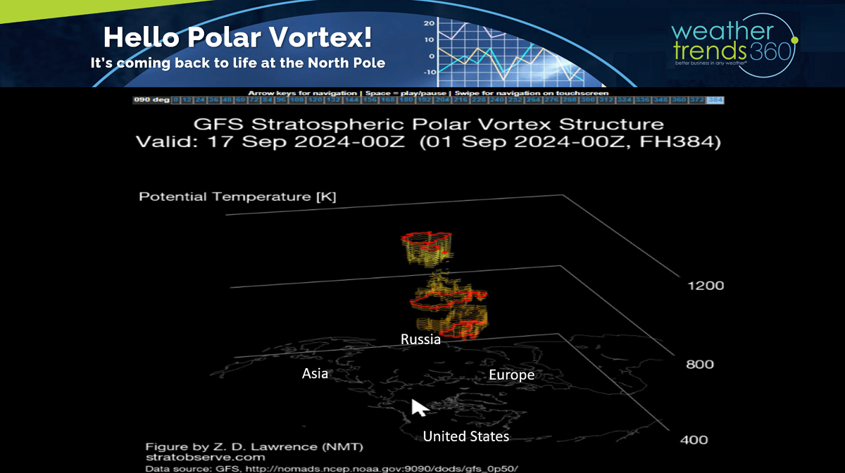
Look what's coming back to life...THE NH POLAR VORTEX! The Polar Vortex mostly disappears during the Summer but reemerges each Fall. Short range models show it starting to redevelop in middle September. WT360 expects a weaker Polar Vortex this year which allows for more frequent cold snaps across North America during Winter.
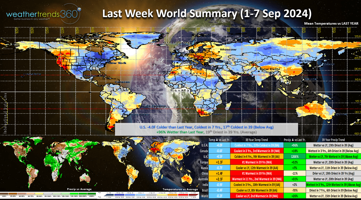
Last Week (1-7 Sep) across the World shows the U.S. trending -4F colder than last year, coldest in 7 years and 17th coldest of the past 39 with below average national temperatures. It was also +96% wetter than a year ago, 19th wettest of the past 39. These are very favorable trends for Back2School and early Fall categories where colder/wetter weather brings stronger seasonal sales. The U.S. was one of the most favorable regions for seasonal sales anywhere in the World.

This week (8-14 Sep) shows the heatwave in the Northwest moving into the Central Plains with the cooler weather pushing to the South Central and Southeast U.S. Very likely we will get a tropical named storm or even a hurricane threatening the Gulf Coast region this week. Southeast TX can't handle any more rain, so flooding will again be the biggest threat. Overall national temperatures trend +0.2F warmer than a year ago but hot 90F days are still down -45% and least in 7 years. Rainfall down -37% nationally, but not so for the Gulf Coast region.

Next week (15-21 Sep) shows a major cool down for the Pacific Northwest with heat building into the Northeast. U.S. overall trends +0.4F warmer than last year, warmest in 6 years and 2nd warmest in 39 years. Rainfall is down -15% vs last year and well below average, so these are very unfavorable trends for retail seasonal merchandise sales. Tropics need to be watched as the cycles become much more favorable for rapid development. The USVI and Puerto Rico areas appear the highest risk during this middle September period.
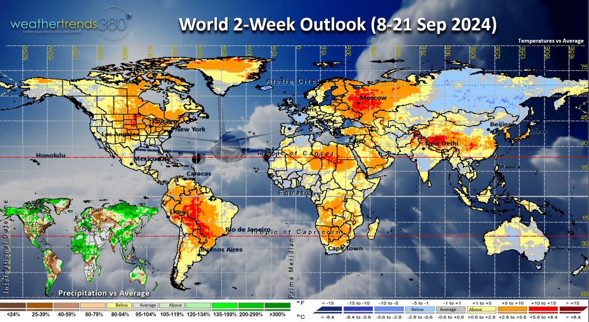
The World 2-week outlook (8-21 Sep) shows the warming trend in the U.S. and Eastern Europe. Unfavorable for Fall merchandise, but a benefit to cold beverage categories.
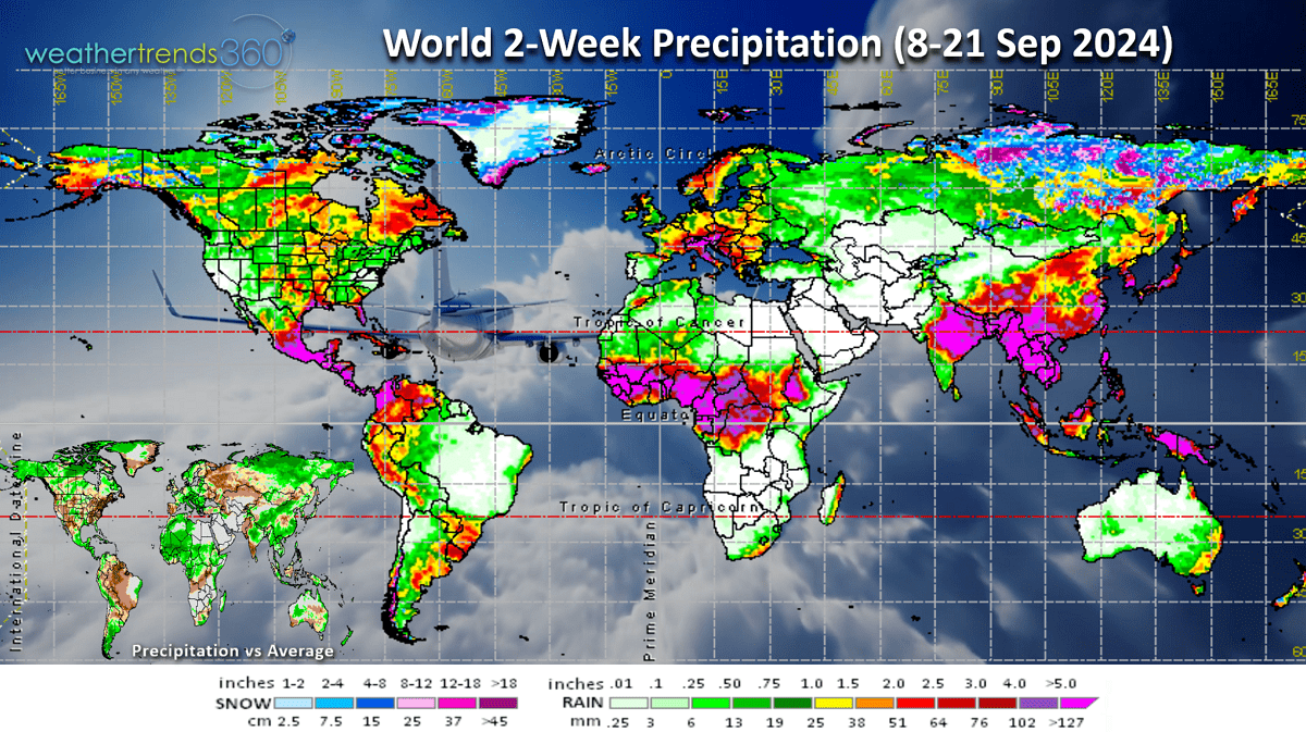
World rainfall continues to show the very wet conditions across Africa, a sign that there will be plenty of tropical systems heading out into the Atlantic in the months ahead.
Have a great week ahead, and don't forget to follow us on social media for frequent updates: Facebook, Twitter, YouTube, Pinterest and Linkedin.
- Captain Kirk out.