Captain's Blog 7 Dec '24 Cold then Moderating Trend
Captain's Log
7 Dec 2024: Happy Saturday! :)
Only 17 shopping days until Christmas! CLICK ON IMAGES FOR A LARGER VIEW.
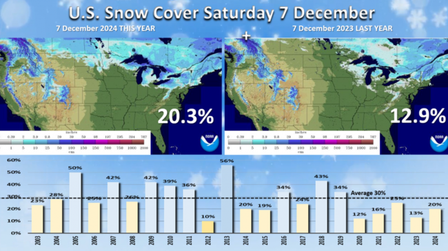
U.S. Snow Cover this morning (7 Dec) shows 20% of the U.S. has snow on the ground vs 13% last year. Much more snow across Southern Canada and the Northeast.
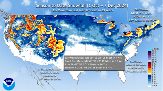
Season-to-date Snowfall shows the big winners for more snow are the Northeast, Southeast and Central Rockies. The Northeast is trending the snowiest in 5 years, +104% more than last year while the Southeast (TN-NC) has the most snow in 10 years. The Central Rockies are also trending up with the most snow in 5 years to date. Erie, PA is one of the big winners with 43" so far this season vs 5" last year. Denver 23" vs 10" last year. Mount Washington NH 90" vs 28" last year.
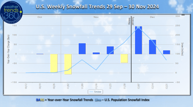
U.S. Weekly snowfall trends show the snowier pattern vs the anemic start last year.
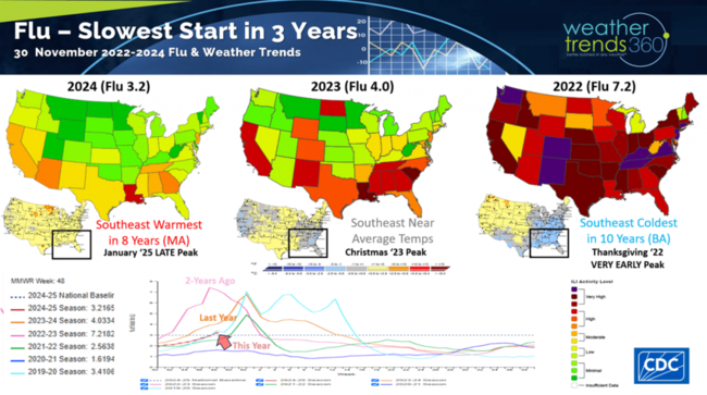
Flu finally crossed baseline, but still the slowest start in 3 years and nothing like the severe 2022 season that peaked at Thanksgiving. This year's peak is more likely in January (late).
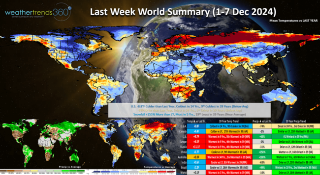
Last week (1-7 Dec) across the World shows the U.S. trending -8.8F colder than last year, coldest in 14 years and 9th coldest of the past 39. Rainfall -74% vs last year, driest in 24 years and 3rd driest in 39 years while snowfall is up +155% vs last year, most in 5 years and 19th least of the past 39 years. These were exceptional trends for seasonal merchandise sales with many volatile categories experiencing triple-digit sales gains. Wet across Brazil with the wettest conditions in 19 years benefiting their crops.
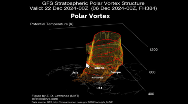
The Polar Vortex has become a bit more symmetrical, which tends to pull the Arctic air back to the pole. But, toward the end of this forecast signs of yet another weakening and wobbling that will likely impact the U.S. late December into early January.
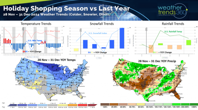
The year-over-year weather trends from Thanksgiving to New Years Eve show a much more favorable holiday shopping season with colder, snowier and drier conditions. This favors stronger seasonal category sales and store traffic for gift sales.
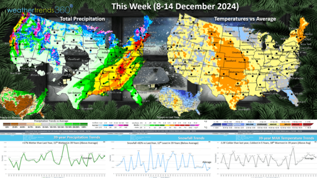
This week (8-14 Dec) The cold air is beginning to sweep off the East Coast with a moderating trend across the U.S. The week still trends -1.9F colder than last year, coldest in 5 years and 18th warmest of the past 39 years. Snowfall up +82% vs last year with continued heavy Lake Effect snow. Rainfall up +17% vs a year ago. The Upper Midwest is the most improved region for stronger seasonal category sales. It does turn much colder along the East Coast, briefly the 12th-14th behind the cold front.
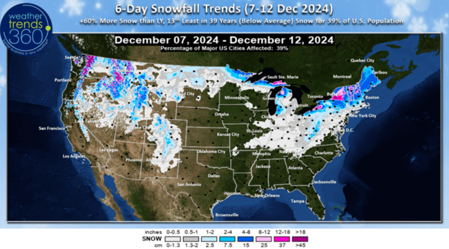
The 6-day (7-12 Dec) snowfall forecast shows +60% more snow than LY but 13th least of the past 39 years with 39% of the U.S. getting some snow. Downwind of the Great Lakes continue to be the favored areas.
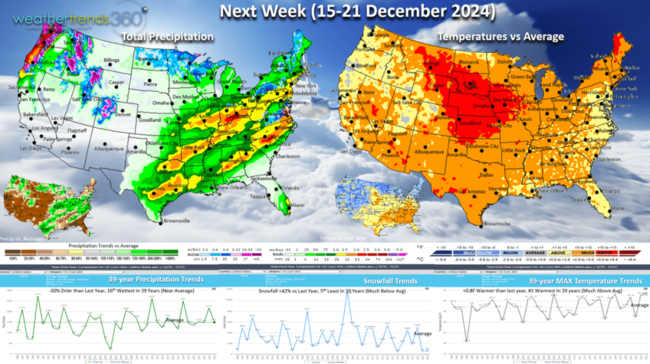
Next week (15-21 Dec) a December thaw with the U.S. trending +0.8F warmer than last year and #1 warmest in 39 years. Snowfall up +42% but still well below average, while rainfall is -30% vs last year and near average for the U.S. overall. Some travel delays likely in the NW, TX to the NE.
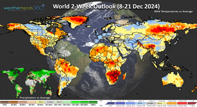
The World 2-week outlook (8-21 Dec) shows the warmup in the U.S. while Europe cools down.
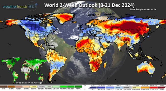
Compared to last year, the U.S., Canada and Europe are much colder favoring stronger seasonal category sales.
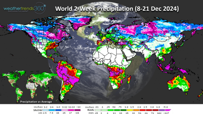
World precipitation (8-21 Dec) shows wet conditions for the Southeast U.S., Snowy New England and Eastern Canada. Another surge in the Pacific Northwest as well.
Have a great week, and don't forget to follow us on social media for frequent updates: Facebook, Twitter, YouTube, Pinterest and Linkedin.
- Captain Kirk out
Only 17 shopping days until Christmas! CLICK ON IMAGES FOR A LARGER VIEW.

U.S. Snow Cover this morning (7 Dec) shows 20% of the U.S. has snow on the ground vs 13% last year. Much more snow across Southern Canada and the Northeast.

Season-to-date Snowfall shows the big winners for more snow are the Northeast, Southeast and Central Rockies. The Northeast is trending the snowiest in 5 years, +104% more than last year while the Southeast (TN-NC) has the most snow in 10 years. The Central Rockies are also trending up with the most snow in 5 years to date. Erie, PA is one of the big winners with 43" so far this season vs 5" last year. Denver 23" vs 10" last year. Mount Washington NH 90" vs 28" last year.

U.S. Weekly snowfall trends show the snowier pattern vs the anemic start last year.

Flu finally crossed baseline, but still the slowest start in 3 years and nothing like the severe 2022 season that peaked at Thanksgiving. This year's peak is more likely in January (late).

Last week (1-7 Dec) across the World shows the U.S. trending -8.8F colder than last year, coldest in 14 years and 9th coldest of the past 39. Rainfall -74% vs last year, driest in 24 years and 3rd driest in 39 years while snowfall is up +155% vs last year, most in 5 years and 19th least of the past 39 years. These were exceptional trends for seasonal merchandise sales with many volatile categories experiencing triple-digit sales gains. Wet across Brazil with the wettest conditions in 19 years benefiting their crops.

The Polar Vortex has become a bit more symmetrical, which tends to pull the Arctic air back to the pole. But, toward the end of this forecast signs of yet another weakening and wobbling that will likely impact the U.S. late December into early January.

The year-over-year weather trends from Thanksgiving to New Years Eve show a much more favorable holiday shopping season with colder, snowier and drier conditions. This favors stronger seasonal category sales and store traffic for gift sales.

This week (8-14 Dec) The cold air is beginning to sweep off the East Coast with a moderating trend across the U.S. The week still trends -1.9F colder than last year, coldest in 5 years and 18th warmest of the past 39 years. Snowfall up +82% vs last year with continued heavy Lake Effect snow. Rainfall up +17% vs a year ago. The Upper Midwest is the most improved region for stronger seasonal category sales. It does turn much colder along the East Coast, briefly the 12th-14th behind the cold front.

The 6-day (7-12 Dec) snowfall forecast shows +60% more snow than LY but 13th least of the past 39 years with 39% of the U.S. getting some snow. Downwind of the Great Lakes continue to be the favored areas.

Next week (15-21 Dec) a December thaw with the U.S. trending +0.8F warmer than last year and #1 warmest in 39 years. Snowfall up +42% but still well below average, while rainfall is -30% vs last year and near average for the U.S. overall. Some travel delays likely in the NW, TX to the NE.

The World 2-week outlook (8-21 Dec) shows the warmup in the U.S. while Europe cools down.

Compared to last year, the U.S., Canada and Europe are much colder favoring stronger seasonal category sales.

World precipitation (8-21 Dec) shows wet conditions for the Southeast U.S., Snowy New England and Eastern Canada. Another surge in the Pacific Northwest as well.
Have a great week, and don't forget to follow us on social media for frequent updates: Facebook, Twitter, YouTube, Pinterest and Linkedin.
- Captain Kirk out